Riparian forest to improve riverbank stabilization [เคนยา]
- ผู้สร้างสรรค์:
- การอัพเดท:
- ผู้รวบรวม: Manuel Fischer
- ผู้เรียบเรียง: –
- ผู้ตรวจสอบ: David Streiff, Alexandra Gavilano
technologies_1567 - เคนยา
ดูส่วนย่อย
ขยายทั้งหมด ย่อทั้งหมด1. ข้อมูลทั่วไป
1.2 รายละเอียดที่ติดต่อได้ของผู้รวบรวมและองค์กรที่เกี่ยวข้องในการประเมินและการจัดเตรียมทำเอกสารของเทคโนโลยี
ผู้ใช้ที่ดิน:
Njiru Fredrick
เคนยา
ชื่อขององค์กรซึ่งอำนวยความสะดวกในการทำเอกสารหรือการประเมินเทคโนโลยี (ถ้าเกี่ยวข้อง)
CDE Centre for Development and Environment (CDE Centre for Development and Environment) - สวิตเซอร์แลนด์1.3 เงื่อนไขการใช้ข้อมูลที่ได้บันทึกผ่านทาง WOCAT
ผู้รวบรวมและวิทยากรหลักยอมรับเงื่อนไขเกี่ยวกับการใช้ข้อมูลที่ถูกบันทึกผ่านทาง WOCAT:
ใช่
2. การอธิบายลักษณะของเทคโนโลยี SLM
2.1 การอธิบายแบบสั้น ๆ ของเทคโนโลยี
คำจำกัดความของเทคโนโลยี:
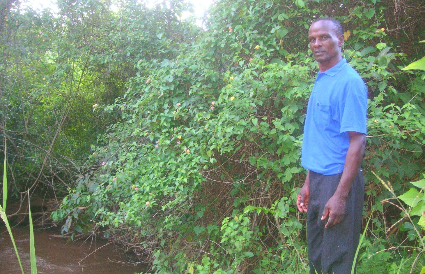
Protection of the riparian zone at Kapingazi River by leaving it undisturbed of human interference
2.2 การอธิบายแบบละเอียดของเทคโนโลยี
คำอธิบาย:
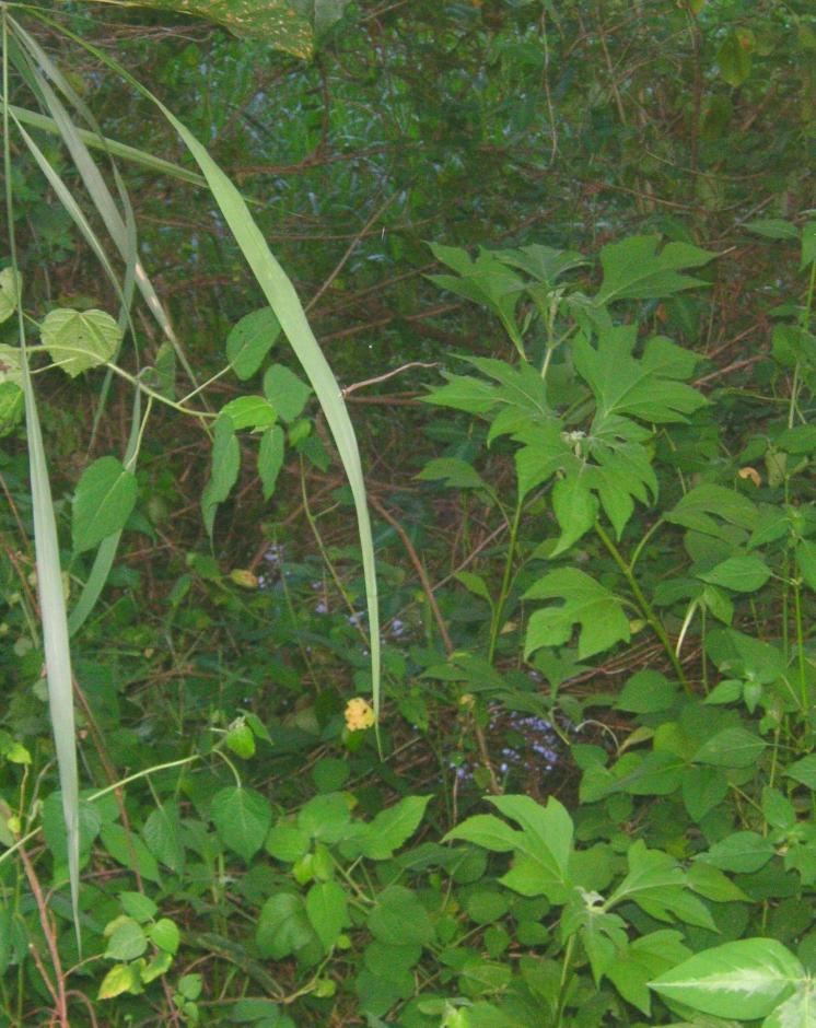
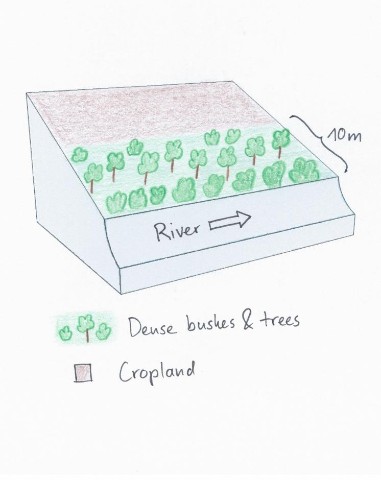
The farmers’ land plot is situated right alongside the river. Heavy floods have eroded a major part of the riverbank and have led to crop failures on the arable land. The farmer reacted to the degradation by stopping agriculture activities on a certain riparian area in order to enable natural vegetation to reclaim the area. The idea is that during the next years, further floods will deposit sediments, which will increase the elevation and fertility of the plot. As soon as enough soil has accumulated and the elevation has increased enough, the farmer wants to plant French beans in the area. Trees were planted in the riparian zone to stabilize the riverbank and to ensure water quality in the river by retaining sediments from nearby fields. Agricultural chemicals are trapped in the riparian buffer as well.
Purpose of the Technology: The purpose is to deal with the regular floods of Kapingazi River and to gain advantages for the farmer and the environmental conditions. Floods are a natural event and happen regularly, therefore strategies are necessary to diminish their negative effects. Furthermore, the human impact on a riparian ecosystem should be kept as small as possible by trapping chemicals and sediments that reduce water quality for down streamers.
Establishment / maintenance activities and inputs: The area where sediments are trapped is not touched by any human interference, the vegetation grows in its natural way. The stabilizing trees of the riparian are planted at the beginning of the rainy season in March or October. Dead seedlings have to be replaced regularly.
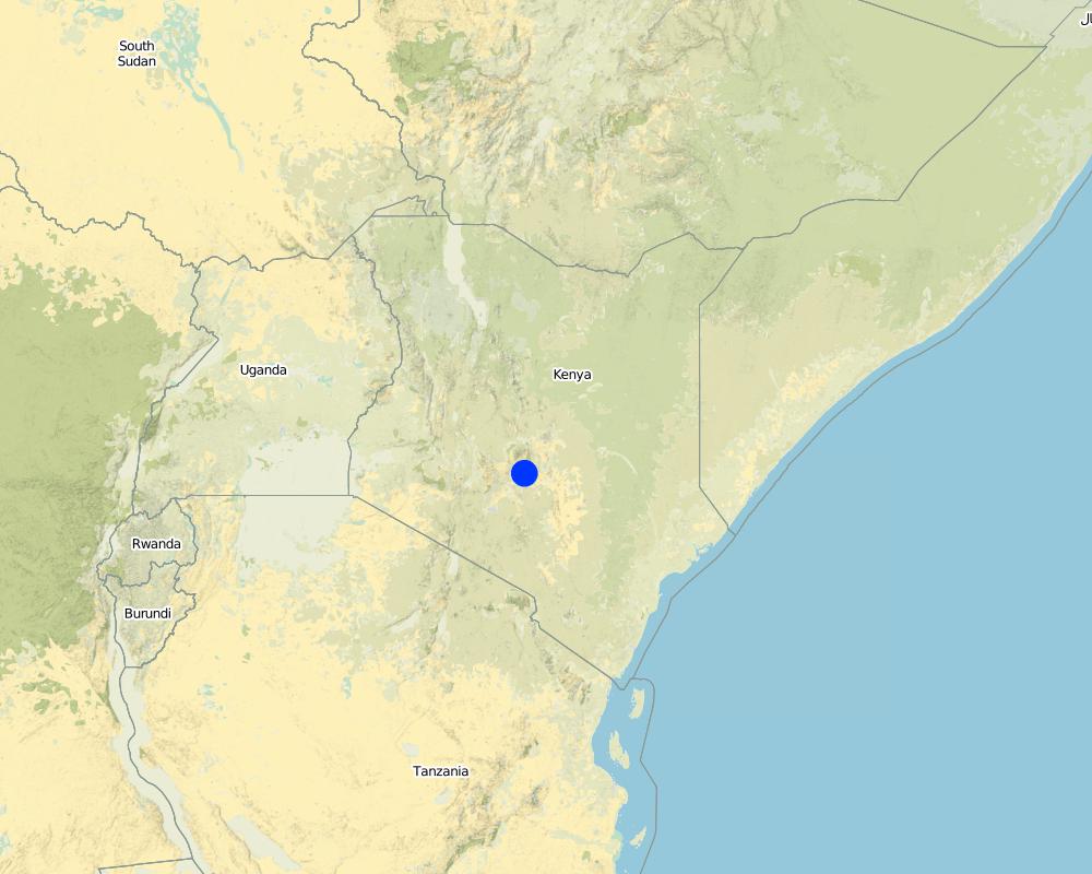
Natural / human environment: Kapingazi River is situated at the south eastern face of Mt. Kenya.It is an agriculturally favourable place due to abundant and reliable rainfall and fertile soils. The studied plot is located at an elevation of 1295 m.a.s.l where mainly maize and vegetables are cultivated. The precipitation amounts to 1150mm a year. Due to the good conditions, this area experiences a steady increase in both population growth and population density.
2.3 รูปภาพของเทคโนโลยี
อัลบั้มสื่อบันทึก
2.5 ประเทศภูมิภาค หรือสถานที่ตั้งที่เทคโนโลยีได้นำไปใช้และได้รับการครอบคลุมโดยการประเมินนี้
ประเทศ:
เคนยา
ภูมิภาค/รัฐ/จังหวัด:
Kenya/Eastern Province
ข้อมูลจำเพาะเพิ่มเติมของสถานที่ตั้ง :
Embu West
ระบุการกระจายตัวของเทคโนโลยี:
- กระจายไปอย่างสม่ำเสมอในพื้นที่
If precise area is not known, indicate approximate area covered:
- < 0.1 ตร.กม.(10 เฮกตาร์)
แสดงความคิดเห็น:
The area where the land use is applied locally is 10 acres. The farmer applies it on 2.5 acres on his 20 acres farm.
Map
×2.6 วันที่การดำเนินการ
ถ้าไม่รู้ปีที่แน่นอน ให้ระบุวันที่โดยประมาณ:
- น้อยกว่า 10 ปี (ไม่นานนี้)
2.7 คำแนะนำของเทคโนโลยี
ให้ระบุว่าเทคโนโลยีถูกแนะนำเข้ามาอย่างไร:
- ด้วยการริเริ่มของผู้ใช้ที่ดินเอง
ความคิดเห็น (ประเภทของโครงการ เป็นต้น) :
2 other people have introduced the same technology. Knowledge about riparian protection was also received through the water resource users association.
3. การจัดประเภทของเทคโนโลยี SLM
3.1 วัตถุประสงค์หลักของเทคโนโลยี
- ลด ป้องกัน ฟื้นฟู การเสื่อมโทรมของที่ดิน
- ลดความเสี่ยงของภัยพิบัติ
3.2 ประเภทของการใช้ที่ดินในปัจจุบันที่ได้นำเทคโนโลยีไปใช้

พื้นที่ปลูกพืช
- การปลูกพืชล้มลุกอายุปีเดียว
- การปลูกไม้ยืนต้น ไม้พุ่ม
Annual cropping - Specify crops:
- cereals - maize
- legumes and pulses - beans
- Mulinga (cordia africana), Moko (cordia monoica), Mokoego, Moo(Markhamia lutea), Muku (Aphananthe aspera), Mukuelgo, Muu
จำนวนของฤดูเพาะปลูกต่อปี:
- 2
ระบุ:
Longest growing period in days: 60 Longest growing period from month to month: march to may Second longest growing period in days: 60 Second longest growing period from month to month: october to november

ป่า/พื้นที่ทำไม้
- ป่ากึ่งธรรมชาติ / พื้นที่ทำไม้
- pruning
ผลิตภัณฑ์และบริการ:
- ไม้ซุง
- ไม้ที่นำมาทำเป็นเชื้อเพลิง
- การป้องกันภัยธรรมชาติ
แสดงความคิดเห็น:
Trees/ shrubs species: Mulinga (cordia africana), Moko (cordia monoica), Mokoego, Moo(Markhamia lutea), Muku (Aphananthe aspera), Mukuelgo, Muu
Major land use problems (compiler’s opinion): Riverbank degradation and small riparian area.
Major land use problems (land users’ perception): Riverbank degradation and destroyed yield due to floods.
Other type of forest: pruning
Forest products and services: timber, fuelwood, protection against natural hazards
Future (final) land use (after implementation of SLM Technology): Forests / woodlands: Fn: Natural
3.3 Has land use changed due to the implementation of the Technology?
Has land use changed due to the implementation of the Technology?
- Yes (Please fill out the questions below with regard to the land use before implementation of the Technology)
พื้นที่ปลูกพืช
- การปลูกพืชล้มลุกอายุปีเดียว
3.4 การใช้น้ำ
การใช้น้ำของที่ดินที่มีการใช้เทคโนโลยีอยู่:
- จากน้ำฝน
3.5 กลุ่ม SLM ที่ตรงกับเทคโนโลยีนี้
- การปิดล้อมพื้นที่ (หยุดการใช้ประโยชน์ สนับสนุนการฟื้นฟู)
- การจัดการน้ำผิวดิน (น้ำพุ แม่น้ำทะเลสาบ ทะเล)
3.6 มาตรการ SLM ที่ประกอบกันเป็นเทคโนโลยี

มาตรการอนุรักษ์ด้วยวิธีพืช
- V1: ต้นไม้และพุ่มไม้คลุมดิน

มาตรการอนุรักษ์ด้วยการจัดการ
- M1: การเปลี่ยนรูปแบบของการใช้ประโยชน์ที่ดิน
แสดงความคิดเห็น:
Main measures: vegetative measures, management measures
Type of vegetative measures: aligned: -along boundary
3.7 รูปแบบหลักของการเสื่อมโทรมของที่ดินที่ได้รับการแก้ไขโดยเทคโนโลยี

การกัดกร่อนของดินโดยน้ำ
- Wr (Riverbank erosion): การกัดกร่อนริมฝั่งแม่น้ำ

การเสื่อมโทรมของดินทางด้านชีวภาพ
- Bc (Reduction of vegetation cover): การลดลงของจำนวนพืชที่ปกคลุมดิน

การเสื่อมโทรมของน้ำ
- Hp (Decline of surface water quality): การลดลงของคุณภาพน้ำที่ผิวดิน
แสดงความคิดเห็น:
Main type of degradation addressed: Wr: riverbank erosion, Hp: decline of surface water quality
Secondary types of degradation addressed: Bc: reduction of vegetation cover
Main causes of degradation: deforestation / removal of natural vegetation (incl. forest fires), over-exploitation of vegetation for domestic use, Heavy / extreme rainfall (intensity/amounts) (due to climate change?), floods, education, access to knowledge and support services (lack of education)
3.8 การป้องกัน การลดลง หรือการฟื้นฟูความเสื่อมโทรมของที่ดิน
ระบุเป้าหมายของเทคโนโลยีกับความเสื่อมโทรมของที่ดิน:
- ป้องกันความเสื่อมโทรมของที่ดิน
- ฟื้นฟูบำบัดที่ดินที่เสื่อมโทรมลงอย่างมาก
4. ข้อมูลจำเพาะด้านเทคนิค กิจกรรมการนำไปปฏิบัติใช้ ปัจจัยนำเข้า และค่าใช้จ่าย
4.1 แบบแปลนทางเทคนิคของเทคโนโลยี
ข้อมูลจำเพาะด้านเทคนิค (แบบแปลนทางเทคนิคของเทคโนโลยี):
The riparian area was regularly affected by floods and riverbank erosion. The land user decided to stop cultivation which allows the development of riparian vegetation to stabilize the riverbank and to raise the elevation.
Location: Embu. Embu West / Eastern Province
Date: 28.12.2013
Technical knowledge required for field staff / advisors: moderate
Technical knowledge required for land users: moderate
Main technical functions: stabilisation of soil (eg by tree roots against land slides)
Secondary technical functions: improvement of ground cover, sediment retention / trapping, sediment harvesting, promotion of vegetation species and varieties (quality, eg palatable fodder)
Aligned: -along boundary
Number of plants per (ha): 33 on 450m
Vertical interval within rows / strips / blocks (m): 3-15
Trees/ shrubs species: Mulinga (cordia africana), Moko (cordia monoica), Mokoego, Moo(Markhamia lutea), Muku, Mukuelgo, Muu
Change of land use type: A plot of cropland was converted to a forest that consists mostly of dense bushes and trees.
ผู้เขียน:
Manuel Fischer
4.2 ข้อมูลทั่วไปเกี่ยวกับการคำนวณปัจจัยนำเข้าและค่าใช้จ่าย
ให้ระบุว่าค่าใช้จ่ายและปัจจัยนำเข้าได้รับการคำนวณอย่างไร:
- ต่อหน่วยเทคโนโลยี
โปรดระบุหน่วย:
Riparian area
Specify dimensions of unit (if relevant):
450 m
ระบุสกุลเงินที่ใช้คำนวณค่าใช้จ่าย:
- USD
ระบุค่าเฉลี่ยของค่าจ้างในการจ้างแรงงานต่อวัน:
2.70
4.3 กิจกรรมเพื่อการจัดตั้ง
| กิจกรรม | Timing (season) | |
|---|---|---|
| 1. | Planting tree seedlings | During rainy season |
| 2. | Replant dead tree seedlings | During rainy season |
| 3. | change of land use |
4.4 ค่าใช้จ่ายของปัจจัยนำเข้าที่จำเป็นสำหรับการจัดตั้ง
| ปัจจัยนำเข้า | หน่วย | ปริมาณ | ค่าใช้จ่ายต่อหน่วย | ค่าใช้จ่ายทั้งหมดต่อปัจจัยนำเข้า | %ของค่าใช้จ่ายที่ก่อให้เกิดขึ้นโดยผู้ใช้ที่ดิน | |
|---|---|---|---|---|---|---|
| แรงงาน | Planting tree seedlings | Persons/day | 2.0 | 3.5 | 7.0 | 100.0 |
| แรงงาน | Replant dead tree seedlings | Persons/day | 2.0 | 3.5 | 7.0 | 100.0 |
| วัสดุด้านพืช | Seedlings | pieces | 33.0 | 0.111 | 3.66 | 100.0 |
| วัสดุด้านพืช | Seedlings for replanting | pieces | 12.0 | 0.111 | 1.33 | 100.0 |
| ค่าใช้จ่ายทั้งหมดของการจัดตั้งเทคโนโลยี | 18.99 | |||||
| Total costs for establishment of the Technology in USD | 18.99 | |||||
แสดงความคิดเห็น:
Duration of establishment phase: 0.2 month(s)
4.6 ค่าใช้จ่ายของปัจจัยนำเข้าและกิจกรรมที่เกิดขึ้นเป็นประจำที่ต้องการการบำรุงรักษา (ต่อปี)
แสดงความคิดเห็น:
Machinery/ tools: Jembe
The costs were calculated for a riparian area with a length of 100m and a width of 10m, since hectares are difficult to apply on a riparian context. The determinant factor for the costs is labour. In this case, the costs are very low because the trees were only planted every 10 metres along the riparian. The seedlings must be bought in a nursery. Most of the bushes regrow naturally and do not need any care.
Some of the seedlings had to be replanted, because they dried up. The required equipment like a spade is available on nearly every farm or can be borrowed from neighbours and is thus not added to the costs.
5. สิ่งแวดล้อมทางธรรมชาติและของมนุษย์
5.1 ภูมิอากาศ
ฝนประจำปี
- < 250 ม.ม.
- 251-500 ม.ม.
- 501-750 ม.ม.
- 751-1,000 ม.ม.
- 1,001-1,500 ม.ม.
- 1,501-2,000 ม.ม.
- 2,001-3,000 ม.ม.
- 3,001-4,000 ม.ม.
- > 4,000 ม.ม.
เขตภูมิอากาศเกษตร
- กึ่งชุ่มชื้น
Thermal climate class: tropics
5.2 สภาพภูมิประเทศ
ค่าเฉลี่ยความลาดชัน:
- ราบเรียบ (0-2%)
- ลาดที่ไม่ชัน (3-5%)
- ปานกลาง (6-10%)
- เป็นลูกคลื่น (11-15%)
- เป็นเนิน (16-30%)
- ชัน (31-60%)
- ชันมาก (>60%)
ธรณีสัณฐาน:
- ที่ราบสูง/ที่ราบ
- สันเขา
- ไหล่เขา
- ไหล่เนินเขา
- ตีนเนิน
- หุบเขา
ระดับความสูง:
- 0-100 เมตร
- 101-500 เมตร
- 501-1,000 เมตร
- 1,001-1,500 เมตร
- 1,501-2,000 เมตร
- 2,001-2,500 เมตร
- 2,501-3,000 เมตร
- 3,001-4,000 เมตร
- > 4,000 เมตร
ความคิดเห็นและข้อมูลจำเพาะเพิ่มเติมเรื่องสภาพภูมิประเทศ:
Altitudinal zone: 1298 m a.s.l.
5.3 ดิน
ค่าเฉลี่ยความลึกของดิน:
- ตื้นมาก (0-20 ซ.ม.)
- ตื้น (21-50 ซ.ม.)
- ลึกปานกลาง (51-80 ซ.ม.)
- ลึก (81-120 ซ.ม.)
- ลึกมาก (>120 ซ.ม.)
เนื้อดิน (ดินชั้นบน):
- ละเอียด/หนัก (ดินเหนียว)
อินทรียวัตถุในดิน:
- ปานกลาง (1-3%)
(ถ้ามี) ให้แนบคำอธิบายเรื่องดินแบบเต็มหรือระบุข้อมูลที่มีอยู่ เช่น ชนิดของดิน ค่า pH ของดินหรือความเป็นกรดของดิน ความสามารถในการแลกเปลี่ยนประจุบวก ไนโตรเจน ความเค็ม เป็นต้น:
Soil fertility is high
Soil drainage / infiltration is medium
Soil water storage capacity is very high
5.4 ความเป็นประโยชน์และคุณภาพของน้ำ
ระดับน้ำใต้ดิน:
<5 เมตร
น้ำไหลบ่าที่ผิวดิน:
ดี
คุณภาพน้ำ (ที่ยังไม่ได้บำบัด):
เป็นน้ำใช้เพื่อการเกษตรเท่านั้น (การชลประทาน)
ความคิดเห็นและข้อมูลจำเพาะเพิ่มเติมเรื่องคุณภาพและปริมาณน้ำ:
Availability of surface water: Sometimes floods, during rains
5.5 ความหลากหลายทางชีวภาพ
ความหลากหลายทางชนิดพันธุ์:
- ปานกลาง
5.6 ลักษณะของผู้ใช้ที่ดินที่นำเทคโนโลยีไปปฏิบัติใช้
แนวทางการตลาดของระบบการผลิต:
- mixed (subsistence/ commercial)
รายได้ที่มาจากนอกฟาร์ม:
- < 10% ของรายได้ทั้งหมด
ระดับของความมั่งคั่งโดยเปรียบเทียบ:
- รวย
เป็นรายบุคคล/ครัวเรือน:
- กลุ่ม/ชุมชน
ระดับของการใช้เครื่องจักรกล:
- งานที่ใช้แรงกาย
เพศ:
- หญิง
- ชาย
ระบุลักษณะอื่นๆที่เกี่ยวข้องของผู้ใช้ที่ดิน:
Land users applying the Technology are mainly Leaders / privileged
Population density: > 500 persons/km2
5.7 Average area of land used by land users applying the Technology
- < 0.5 เฮกตาร์
- 0.5-1 เฮกตาร์
- 1-2 เฮกตาร์
- 2-5 เฮกตาร์
- 5-15 เฮกตาร์
- 15-50 เฮกตาร์
- 50-100 เฮกตาร์
- 100-500 เฮกตาร์
- 500-1,000 เฮกตาร์
- 1,000-10,000 เฮกตาร์
- >10,000 เฮกตาร์
พิจารณาว่าเป็นขนาดเล็ก กลาง หรือขนาดใหญ่ (ซึ่งอ้างอิงถึงบริบทระดับท้องถิ่น):
- ขนาดเล็ก
แสดงความคิดเห็น:
Average area of land owned or leased by land users applying the Technology: Also 5-15 ha for cropland and 0.5 - 1 ha for woodland
5.8 กรรมสิทธิ์ในที่ดิน สิทธิในการใช้ที่ดินและสิทธิในการใช้น้ำ
กรรมสิทธิ์ในที่ดิน:
- รายบุคคล ไม่ได้รับสิทธิครอบครอง
สิทธิในการใช้ที่ดิน:
- รายบุคคล
สิทธิในการใช้น้ำ:
- เกี่ยวกับชุมชน (ถูกจัดระเบียบ)
5.9 การเข้าถึงบริการและโครงสร้างพื้นฐาน
สุขภาพ:
- จน
- ปานกลาง
- ดี
การศึกษา:
- จน
- ปานกลาง
- ดี
ความช่วยเหลือทางด้านเทคนิค:
- จน
- ปานกลาง
- ดี
การจ้างงาน (เช่น ภายนอกฟาร์ม):
- จน
- ปานกลาง
- ดี
ตลาด:
- จน
- ปานกลาง
- ดี
พลังงาน:
- จน
- ปานกลาง
- ดี
ถนนและการขนส่ง:
- จน
- ปานกลาง
- ดี
น้ำดื่มและการสุขาภิบาล:
- จน
- ปานกลาง
- ดี
บริการด้านการเงิน:
- จน
- ปานกลาง
- ดี
6. ผลกระทบและสรุปคำบอกกล่าว
6.1 ผลกระทบในพื้นที่ดำเนินการ (On-site) จากการใช้เทคโนโลยี
ผลกระทบทางด้านเศรษฐกิจและสังคม
การผลิต
การผลิตพืชผล
การผลิตพืชที่ใช้เลี้ยงปศุสัตว์
การผลิตไม้
แสดงความคิดเห็น/ระบุ:
Through prunning
ผลกระทบด้านสังคมวัฒนธรรมอื่น ๆ
SLM หรือความรู้เรื่องความเสื่อมโทรมของที่ดิน
ผลกระทบด้านนิเวศวิทยา
วัฐจักรน้ำหรือน้ำบ่า
ปริมาณน้ำ
แสดงความคิดเห็น/ระบุ:
in river
คุณภาพน้ำ
น้ำไหลบ่าที่ผิวดิน
ดิน
สิ่งปกคลุมดิน
การสูญเสียดิน
ความหลากหลายทางชีวภาพของพืชและสัตว์
ความหลากหลายทางชีวภาพของพืช
ความหลากหลายทางชีวภาพของสัตว์
ชนิดพันธุ์ที่ให้ประโยชน์
ความหลากหลายของสัตว์
ลดความเสี่ยงของภัยพิบัติ
ผลกระทบจากน้ำท่วม
ผลกระทบด้านนิเวศวิทยาอื่น ๆ
Riverbank erosion
6.2 ผลกระทบนอกพื้นที่ดำเนินการ (Off-site) จากการใช้เทคโนโลยี
น้ำที่ใช้ประโยชน์ได้
การไหลของน้ำคงที่และสม่ำเสมอในช่วงฤดูแล้ง
การเกิดมลพิษในน้ำบาดาลหรือแม่น้ำ
ความสามารถต้านทานการเปลี่ยนแปลง / ความสามารถในการคัดกรอง
6.3 การเผชิญและความตอบสนองของเทคโนโลยีต่อการเปลี่ยนแปลงสภาพภูมิอากาศที่ค่อยเป็นค่อยไป และสภาพรุนแรงของภูมิอากาศ / ภัยพิบัติ (ที่รับรู้ได้โดยผู้ใช้ที่ดิน)
การเปลี่ยนแปลงสภาพภูมิอากาศที่ค่อยเป็นค่อยไป
การเปลี่ยนแปลงสภาพภูมิอากาศที่ค่อยเป็นค่อยไป
| ฤดู | increase or decrease | เทคโนโลยีมีวิธีการรับมืออย่างไร | |
|---|---|---|---|
| อุณหภูมิประจำปี | เพิ่มขึ้น | ดี |
สภาพรุนแรงของภูมิอากาศ (ภัยพิบัติ)
ภัยพิบัติทางอุตุนิยมวิทยา
| เทคโนโลยีมีวิธีการรับมืออย่างไร | |
|---|---|
| พายุฝนประจำท้องถิ่น | ดี |
| พายุลมประจำท้องถิ่น | ดี |
ภัยพิบัติจากสภาพภูมิอากาศ
| เทคโนโลยีมีวิธีการรับมืออย่างไร | |
|---|---|
| ภัยจากฝนแล้ง | ดี |
ภัยพิบัติจากน้ำ
| เทคโนโลยีมีวิธีการรับมืออย่างไร | |
|---|---|
| น้ำท่วมตามปกติ (แม่น้ำ) | ดี |
ผลลัพธ์ตามมาที่เกี่ยวข้องกับภูมิอากาศอื่น ๆ
ผลลัพธ์ตามมาที่เกี่ยวข้องกับภูมิอากาศอื่น ๆ
| เทคโนโลยีมีวิธีการรับมืออย่างไร | |
|---|---|
| ช่วงการปลูกพืชที่ลดลงมา | ดี |
6.4 การวิเคราะห์ค่าใช้จ่ายและผลประโยชน์ที่ได้รับ
ผลประโยชน์ที่ได้รับเปรียบเทียบกับค่าใช้จ่ายในการจัดตั้งเป็นอย่างไร (จากมุมมองของผู้ใช้ที่ดิน)
ผลตอบแทนระยะสั้น:
ด้านลบเล็กน้อย
ผลตอบแทนระยะยาว:
ด้านบวกเล็กน้อย
ผลประโยชน์ที่ได้รับเปรียบเทียบกับค่าใช้จ่ายในการบำรุงรักษาหรือต้นทุนที่เกิดขึ้นซ้ำอีก เป็นอย่างไร (จากมุมมองของผู้ใช้ที่ดิน)
ผลตอบแทนระยะสั้น:
เป็นกลางหรือสมดุล
ผลตอบแทนระยะยาว:
ด้านบวกเล็กน้อย
6.5 การปรับตัวของเทคโนโลยี
- ครั้งเดียวหรือเป็นการทดลอง
ถ้ามีข้อมูลให้บอกปริมาณด้วย (จำนวนของครัวเรือนหรือครอบคลุมพื้นที่):
1 household
Of all those who have adopted the Technology, how many did so spontaneously, i.e. without receiving any material incentives/ payments?
- 91-100%
แสดงความคิดเห็น:
There is a moderate trend towards spontaneous adoption of the Technology
Comments on adoption trend: The other farmers noticed the positive impacts and adopt the technology.
6.7 จุดแข็ง / ข้อได้เปรียบ / โอกาสของเทคโนโลยี
| จุดแข็ง / ข้อได้เปรียบ / โอกาสในทัศนคติของผู้ใช้ที่ดิน |
|---|
|
There are no more crop failures and the riverbank is stabilized How can they be sustained / enhanced? In the other areas that are not much more elevated than the river, flood resistant plants like Napier grass should be planted. |
|
The trees and the riparian bushes provide timber and fuelwood. How can they be sustained / enhanced? Careful use of the resources ensures sustainability. |
| จุดแข็ง / ข้อได้เปรียบ / โอกาสในทัศนคติของผู้รวบรวมหรือวิทยากรหลัก |
|---|
|
The established forest is a great success for the local fauna and flora in terms of biodiversity How can they be sustained / enhanced? More areas like this could be established |
6.8 จุดอ่อน / ข้อเสียเปรียบ / ความเสี่ยงของเทคโนโลยีและวิธีการแก้ไข
| จุดอ่อน / ข้อเสียเปรียบ / ความเสี่ยงในทัศนคติของผู้ใช้ที่ดิน | มีวิธีการแก้ไขได้อย่างไร |
|---|---|
| The shrub-covered area is no longer available for cultivation and leads to a decrease in income. | If the farmer depends on the productivity of the riparian, he could plant Napier grass and prune the trees. |
| จุดอ่อน / ข้อเสียเปรียบ / ความเสี่ยงในทัศนคติของผู้รวบรวมหรือวิทยากรหลัก | มีวิธีการแก้ไขได้อย่างไร |
|---|---|
| As soon as the riparian forest is silted up and floods become more rare, the farmer plans a deforestation and cultivation of beans in the riparian area with riparian vegetation strips of 5m. | The riparian forest should be kept there to improve ecological benefits and to sustain reduced erosion. |
7. การอ้างอิงและการเชื่อมต่อ
7.1 วิธีการและแหล่งข้อมูล
ลิงก์และโมดูล
ขยายทั้งหมด ย่อทั้งหมดลิงก์
ไม่มีลิงก์
โมดูล
ไม่มีโมดูล