Environmentally-Friendly Community Practices [Moldova, Republic of]
- Creation:
- Update:
- Compiler: Valentin Ciubotaru
- Editors: Valentin Ciubotaru, UNCCD PRAIS
- Reviewers: Farrukh Nazarmavloev, William Critchley, Rima Mekdaschi Studer
Practicile comunitare prietenoase mediului
technologies_1816 - Moldova, Republic of
View sections
Expand all Collapse all1. General information
1.2 Contact details of resource persons and institutions involved in the assessment and documentation of the Technology
Key resource person(s)
SLM specialist:
Ciubotaru Valentin
+37322 545733 / +37322 69134294
ngobios@yahoo.com / valentin.ciubotaru@yahoo.com
NGO BIOS
72/3 Columna str., office nr. 3. Chisinau- MD-2012
Moldova, Republic of
Name of the institution(s) which facilitated the documentation/ evaluation of the Technology (if relevant)
NGO BIOS (.) - Moldova, Republic of1.3 Conditions regarding the use of data documented through WOCAT
When were the data compiled (in the field)?
02/06/2014
The compiler and key resource person(s) accept the conditions regarding the use of data documented through WOCAT:
Yes
1.4 Declaration on sustainability of the described Technology
Is the Technology described here problematic with regard to land degradation, so that it cannot be declared a sustainable land management technology?
No
2. Description of the SLM Technology
2.1 Short description of the Technology
Definition of the Technology:
Community area development plans were developed taking into consideration the main problems, opportunities, necessities and wishes of the local population. All communities included afforestation of severely eroded land, re-establishing degraded forest belts and planting new forest lines, creating protection shields for aquatic areas, and an ecological education community program.
2.2 Detailed description of the Technology
Description:
Community area development plans were developed for six communities for the period of 2008-2028, taking into consideration the main problems, opportunities, requirements and wishes of the local population. Special attention was paid to environmental impact assessment to harmonize economic and social development with environmental protection. All communities included afforestation of severely eroded land, re-establishing degraded forest belts and planting new forest lines, creating protection shields for aquatic areas, and elaborating and implementing a ecological education community program.
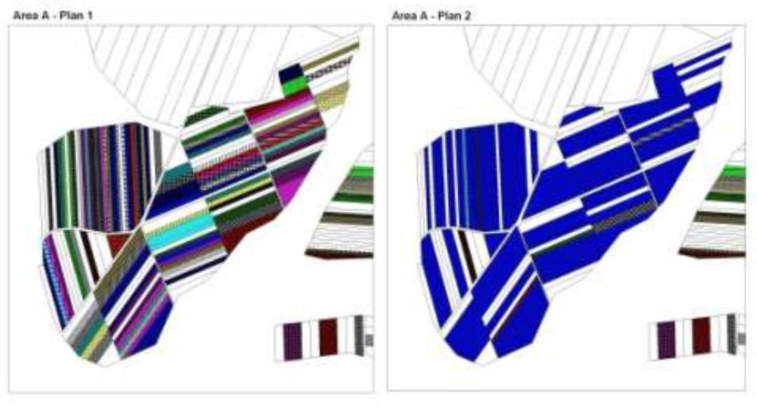
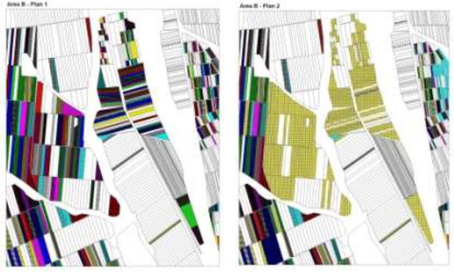
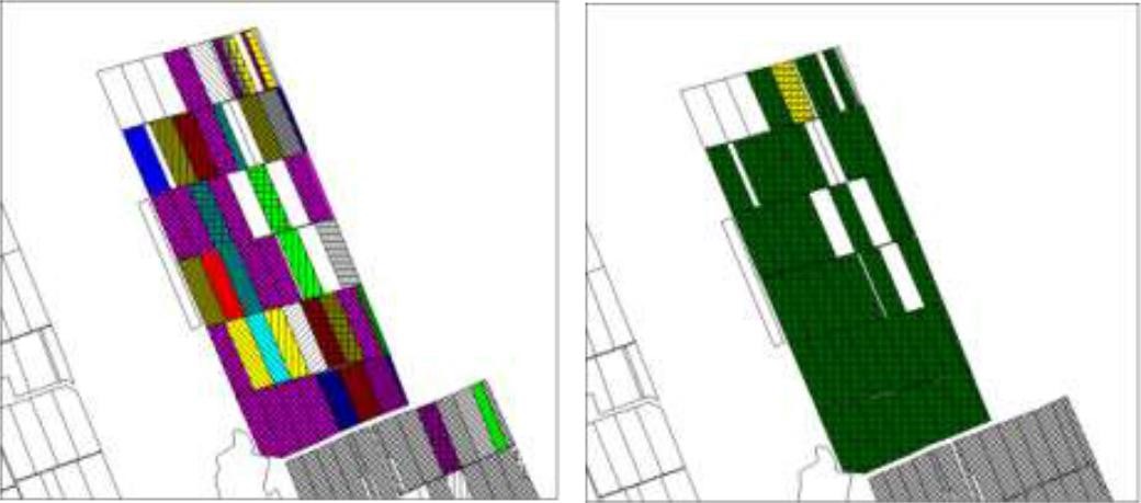
The first action implemented was agricultural land re-parcelling, based on FAO guidelines. Training programs were conducted for project staff and beneficiaries. Following land planning, discussions and individual negotiations with each land owner, the project promoted the application of the following land parcels operations: sale, exchange and long term lease. The costs incurred during land transactions were fully covered by the project. The Land Use Scheme implies changes in some categories of use and especially expanding the area of vineyards and orchards as well as using agricultural land for community development according to the needs and wishes of the population. Land re-parcelling offers farmers the possibility of rearranging agricultural land according to ecological principles and potential.
The overall goal of land re-parcelling component was to respond to the concerns of the Government and others about the fragmentation of agricultural land: it focussed on small peasant farms as its primary target group. The specific objectives of the pilot action were:
- to test the demand for and feasibility of land re-parcelling with small landowners as the primary target group;
- to facilitate development of 6 community area development plans, taking into account environmental impact assessment.
- to use the pilot experience as the basis for designing a potential national-level approach, including techniques, resource requirements and legislative framework;
- to assess the impact of re-parcelling at the local level, including on land markets, agricultural production, and equity.
The re-parcelling activities were extended to 40 villages on the proviso that the concept and the experience of the implemented re-parcelling pilots would be precisely followed. Based on this experience, the Ministry of Agriculture is in active partnership with National Agency for Rural Development and NGO BIOS, supported by the FAO-developed National Strategy for Land Consolidation.
2.3 Photos of the Technology
Media Gallery
2.5 Country/ region/ locations where the Technology has been applied and which are covered by this assessment
Country:
Moldova, Republic of
Further specification of location:
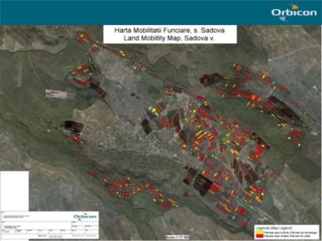
The six communes which form the pilot area, namely Basauca village Rezina district, Sadova village Calarasi district, Calmatui village Hincesti district, Bolduresti community of Cantemir district, Baimaclia community Cantemir district, Opaci village Causeni district, Republic of Moldova. The experience was replicated in 40 villages.
Comments:
The six communes which form the pilot area, namely Basauca village Rezina district, Sadova village Calarasi district, Calmatui village Hincesti district, Bolduresti community of Cantemir district, Baimaclia community Cantemir district, Opaci village Causeni district, Republic of Moldova.
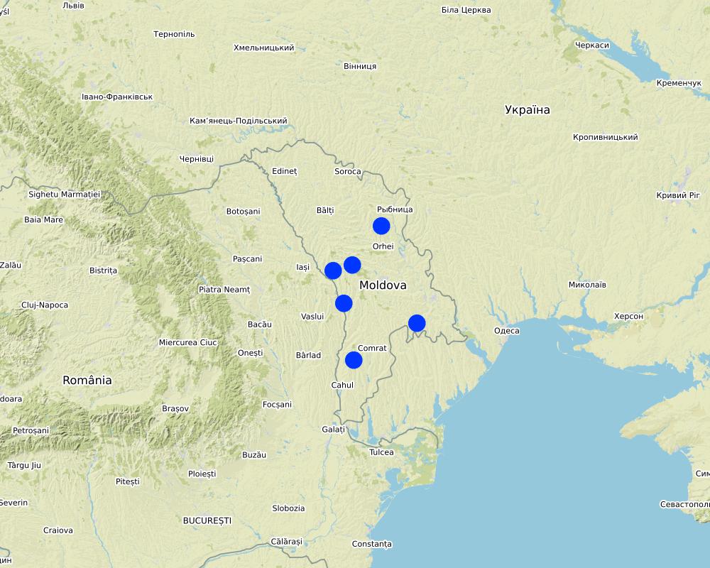
Map
×2.6 Date of implementation
If precise year is not known, indicate approximate date:
- less than 10 years ago (recently)
2.7 Introduction of the Technology
Specify how the Technology was introduced:
- during experiments/ research
- through projects/ external interventions
3. Classification of the SLM Technology
3.1 Main purpose(s) of the Technology
- improve production
- reduce, prevent, restore land degradation
- conserve ecosystem
- protect a watershed/ downstream areas – in combination with other Technologies
- create beneficial economic impact
3.2 Current land use type(s) where the Technology is applied

Cropland
- Annual cropping
- Perennial (non-woody) cropping

Other
Specify:
- Land fragmentation; - Environmentally unsustainable land management practices; - Illegal cutting of forests, leading to the destruction of forest belts and buffer strips; - Point and non-point sources of pollution, - Over-grazing..
3.3 Further information about land use
Water supply for the land on which the Technology is applied:
- mixed rainfed-irrigated
Number of growing seasons per year:
- 1
3.4 SLM group to which the Technology belongs
- rotational systems (crop rotation, fallows, shifting cultivation)
- integrated crop-livestock management
- cross-slope measure
3.5 Spread of the Technology
Specify the spread of the Technology:
- evenly spread over an area
If the Technology is evenly spread over an area, indicate approximate area covered:
- > 10,000 km2
Comments:
The Technology was replicated to 40 villages in South, Center and North regions of Moldova
3.6 SLM measures comprising the Technology

agronomic measures
- A1: Vegetation/ soil cover
- A2: Organic matter/ soil fertility

vegetative measures
- V1: Tree and shrub cover
- V2: Grasses and perennial herbaceous plants

structural measures
- S5: Dams, pans, ponds
- S6: Walls, barriers, palisades, fences
- S9: Shelters for plants and animals

management measures
- M1: Change of land use type
- M2: Change of management/ intensity level
Comments:
- Implementing activities of protection, maintenance and improving of degraded soil fertility;
- Agroforestry consisted of planting of tree rows on cultivated lands, primarily of windbreaks and anti-erosion protective belts.
- Improving the quality of pastures and implementing controlled pasturing.|
- Regeneration of degraded commune forest as well as existing forest protective belts.
- Planting of tree rows on cultivated lands, primarily of windbreaks and anti-erosion protective belts. |
Facilitate the development of farms by reducing the fragmentation and expanding the area of agricultural lands. The project provides assistance to land owners and farmers to undertake voluntarily land transactions based on market economy principles, elaborating the land ownership maps (GIS MapInfo|
The elaboration of the Community Area Development Plans was effected together with the local public administration, professors, legal persons, non-governmental organizations, and the population of communities with active involvement of Zonal Ecologic Agencies, Preventive Medicine Centers, |Agriculture and Economy Departments of district Executive Committees.
3.7 Main types of land degradation addressed by the Technology

soil erosion by water
- Wt: loss of topsoil/ surface erosion
- Wr: riverbank erosion
- Wo: offsite degradation effects

soil erosion by wind
- Et: loss of topsoil
- Ed: deflation and deposition

physical soil deterioration
- Pc: compaction
- Pu: loss of bio-productive function due to other activities

biological degradation
- Bc: reduction of vegetation cover
- Bh: loss of habitats
- Bq: quantity/ biomass decline
- Bs: quality and species composition/ diversity decline
- Bl: loss of soil life
3.8 Prevention, reduction, or restoration of land degradation
Specify the goal of the Technology with regard to land degradation:
- prevent land degradation
- reduce land degradation
4. Technical specifications, implementation activities, inputs, and costs
4.4 Establishment activities
| Activity | Type of measure | Timing | |
|---|---|---|---|
| 1. | Implementing activities of protection, maintenance and improving of degraded soil fertility | ||
| 2. | Agroforestry consisting of planting of tree rows on cultivated lands, primarily of windbreaks and anti-erosion protective belts. | ||
| 3. | Improving the quality of pastures and implementing controlled pasturing| | ||
| 4. | Regeneration of degraded commune forest as well as existing forest protective belts | ||
| 5. | Planting of tree rows on cultivated lands, primarily of windbreaks and anti-erosion protective belts |
4.5 Costs and inputs needed for establishment
If land user bore less than 100% of costs, indicate who covered the remaining costs:
The Project
5. Natural and human environment
5.1 Climate
Annual rainfall
- < 250 mm
- 251-500 mm
- 501-750 mm
- 751-1,000 mm
- 1,001-1,500 mm
- 1,501-2,000 mm
- 2,001-3,000 mm
- 3,001-4,000 mm
- > 4,000 mm
Indicate the name of the reference meteorological station considered:
Chisinau, Nisporeni, Calarasi, Cahul, Leova, Hincesti, Rezina
Agro-climatic zone
- semi-arid
Moldova's climate is moderately continental: the summers are warm and long, with temperatures averaging 20 °C, and the winters are relatively mild and dry, with January temperatures averaging −4 °C. Annual rainfall, which ranges from around 600 millimeters in the north to 400 millimeters in the south, can vary greatly. The heaviest rainfall occurs in summer; heavy showers and thunderstorms are common. Because of the irregular terrain, heavy summer rains often cause erosion and river silting.|
5.2 Topography
Slopes on average:
- flat (0-2%)
- gentle (3-5%)
- moderate (6-10%)
- rolling (11-15%)
- hilly (16-30%)
- steep (31-60%)
- very steep (>60%)
Landforms:
- plateau/plains
- ridges
- mountain slopes
- hill slopes
- footslopes
- valley floors
Altitudinal zone:
- 0-100 m a.s.l.
- 101-500 m a.s.l.
- 501-1,000 m a.s.l.
- 1,001-1,500 m a.s.l.
- 1,501-2,000 m a.s.l.
- 2,001-2,500 m a.s.l.
- 2,501-3,000 m a.s.l.
- 3,001-4,000 m a.s.l.
- > 4,000 m a.s.l.
Indicate if the Technology is specifically applied in:
- not relevant
Comments and further specifications on topography:
Most of Moldova's territory is a moderate hilly plateau cut deeply by many streams and rivers. Geologically, Moldova lies primarily on deep sedimentary rock that gives way to harder crystalline outcroppings only in the north. Moldova's hills are part of the Moldavian Plateau, which geologically originate from the Carpathian Mountains. |
5.3 Soils
Soil depth on average:
- very shallow (0-20 cm)
- shallow (21-50 cm)
- moderately deep (51-80 cm)
- deep (81-120 cm)
- very deep (> 120 cm)
Soil texture (topsoil):
- medium (loamy, silty)
Soil texture (> 20 cm below surface):
- medium (loamy, silty)
Topsoil organic matter:
- high (>3%)
- medium (1-3%)
If available, attach full soil description or specify the available information, e.g. soil type, soil PH/ acidity, Cation Exchange Capacity, nitrogen, salinity etc.
About 75% of Moldova is covered by black earth or chernozem. In the northern hills, more clay textured soils are found; in the south, red-earth soil is predominant. The soil becomes less fertile toward the south but can still support grape and sunflower production. The hills have forest soils, while a small portion in southern Moldova is in the steppe zone, although most steppe areas today are cultivated. The lower reaches of the Prut and Dniester rivers and the southern river valleys are saline
5.4 Water availability and quality
Ground water table:
5-50 m
Availability of surface water:
medium
Water quality (untreated):
poor drinking water (treatment required)
Is water salinity a problem?
Yes
Specify:
high water mineralisation
Is flooding of the area occurring?
Yes
Regularity:
episodically
5.5 Biodiversity
Species diversity:
- medium
Habitat diversity:
- low
5.6 Characteristics of land users applying the Technology
Sedentary or nomadic:
- Sedentary
Market orientation of production system:
- mixed (subsistence/ commercial
Off-farm income:
- 10-50% of all income
Relative level of wealth:
- poor
Individuals or groups:
- individual/ household
- groups/ community
Level of mechanization:
- mechanized/ motorized
Gender:
- women
- men
Age of land users:
- middle-aged
- elderly
5.7 Average area of land owned or leased by land users applying the Technology
- < 0.5 ha
- 0.5-1 ha
- 1-2 ha
- 2-5 ha
- 5-15 ha
- 15-50 ha
- 50-100 ha
- 100-500 ha
- 500-1,000 ha
- 1,000-10,000 ha
- > 10,000 ha
Is this considered small-, medium- or large-scale (referring to local context)?
- small-scale
Comments:
After independence (1991), land was privatized. The average family was entitled to plots of between 1.5 and 2.5 ha. Four categories of farms emerged: (i) small individual farmers; (ii) individual commercial farmers; (iii) farmers in associations with close relatives; and (iv) farmers in groups (from less than 10 farmers to large, joint-stock companies). The small size of many farms precludes the use of agricultural machinery and advanced technology. |
5.8 Land ownership, land use rights, and water use rights
Land ownership:
- communal/ village
- individual, titled
Land use rights:
- leased
- individual
Water use rights:
- open access (unorganized)
- individual
Comments:
The principal activity of local farmers is crop farming; main arable crops are maize and wheat. The cultivation of grapes and fruits is another traditional element of agriculture in this area. Vineyards and orchards take a significant share of cropped land. Income is derived from sale of agricultural produce, including milk and eggs, from forest products, but also from seasonal work at the small workshops in their own and surrounding communities.|
Income depends much on weather conditions and agricultural policies. Estimated average income per person is 50 US dollars per month for the last three years (no including this year).
5.9 Access to services and infrastructure
health:
- poor
- moderate
- good
education:
- poor
- moderate
- good
technical assistance:
- poor
- moderate
- good
employment (e.g. off-farm):
- poor
- moderate
- good
markets:
- poor
- moderate
- good
energy:
- poor
- moderate
- good
roads and transport:
- poor
- moderate
- good
drinking water and sanitation:
- poor
- moderate
- good
financial services:
- poor
- moderate
- good
6. Impacts and concluding statements
6.1 On-site impacts the Technology has shown
Socio-economic impacts
Production
crop production
animal production
forest/ woodland quality
product diversity
production area
land management
Water availability and quality
drinking water availability
drinking water quality
water availability for livestock
Income and costs
farm income
diversity of income sources
Ecological impacts
Water cycle/ runoff
harvesting/ collection of water
surface runoff
Soil
soil moisture
soil cover
soil loss
soil crusting/ sealing
soil compaction
soil organic matter/ below ground C
Biodiversity: vegetation, animals
Vegetation cover
biomass/ above ground C
plant diversity
animal diversity
habitat diversity
6.2 Off-site impacts the Technology has shown
downstream flooding
downstream siltation
groundwater/ river pollution
buffering/ filtering capacity
damage on neighbours' fields
6.3 Exposure and sensitivity of the Technology to gradual climate change and climate-related extremes/ disasters (as perceived by land users)
Comments:
Expected changes include utilization of local resources, change in existing land use management, change in landscape, changes in erosion rates, etc. These in their turn are expected to lead to social and economic impacts on people.
• The main environmental indicators are largely the same. • The expected environmental impact of re-parcelling and initiated actions are significant, especially in the long run. |
People learn to live with the new approach, new land structure, alternative solutions of solving their own problems, etc. |
Implementation of the land re-parcelling project contributes to improving the structure of the agricultural land, efficient use of technology, increase the possibility of arranging the community territory with a consolidated network of roads; |
The economic levels stayed practically unchanged, while social cohesion and culture has somewhat improved from exposure to new things, common work. The expected social impact of re-parcelling and initiated actions are significant, especially in the long run.|
Expected changes include increased jobs for people, there will be favourable conditions for the young population to stay in the rural area and those who left abroad could return back and start various businesses in their village.|
Improving the community infrastructure by water and natural gas supply, etc. It offers farmers a possibility to start processing enterprises so that they can sell the final product at a higher price than the raw products.
6.4 Cost-benefit analysis
How do the benefits compare with the establishment costs (from land users’ perspective)?
Short-term returns:
slightly positive
Long-term returns:
positive
How do the benefits compare with the maintenance/ recurrent costs (from land users' perspective)?
Short-term returns:
slightly positive
Long-term returns:
positive
6.5 Adoption of the Technology
- 10-50%
Of all those who have adopted the Technology, how many have did so spontaneously, i.e. without receiving any material incentives/ payments?
- 10-50%
6.6 Adaptation
Has the Technology been modified recently to adapt to changing conditions?
No
6.7 Strengths/ advantages/ opportunities of the Technology
| Strengths/ advantages/ opportunities in the compiler’s or other key resource person’s view |
|---|
|
Business opportunities related to community development, etc. | Highly motivated local governments Highly motivated farmers |
7. References and links
7.1 Methods/ sources of information
- interviews with land users
6000
7.3 Links to relevant information which is available online
Title/ description:
Assessment Study on Land Re-parceling Pilot Project in 6 Villages in Moldova
URL:
http://www.capmu.md/wp-content/uploads/images/docs/Impact_Assessment/Final%20report%20IA%20land%20rep.pdf
Title/ description:
Experiences with land reform and land consolidation in Moldova
URL:
file:///C:/Users/USER/Downloads/59-357-1-PB.pdf
Links and modules
Expand all Collapse allLinks
No links
Modules
No modules