Environmentally-Friendly Community Practices [សាធារណរដ្ឋម៉ុលដាវី]
- ការបង្កើត៖
- បច្ចុប្បន្នភាព
- អ្នកចងក្រង៖ Valentin Ciubotaru
- អ្នកកែសម្រួល៖ Valentin Ciubotaru, UNCCD PRAIS
- អ្នកត្រួតពិនិត្យច្រើនទៀត៖ Farrukh Nazarmavloev, William Critchley, Rima Mekdaschi Studer
Practicile comunitare prietenoase mediului
technologies_1816 - សាធារណរដ្ឋម៉ុលដាវី
ពិនិត្យមើលគ្រប់ផ្នែក
ពង្រីកមើលទាំងអស់ បង្រួមទាំងអស់1. ព័ត៌មានទូទៅ
1.2 ព័ត៌មានលម្អិតពីបុគ្គលសំខាន់ៗ និងស្ថាប័នដែលចូលរួមក្នុងការវាយតម្លៃ និងចងក្រងឯកសារនៃបច្ចេកទេស
បុគ្គលសំខាន់ម្នាក់ (ច្រើននាក់)
អ្នកជំនាញឯកទេស SLM:
Ciubotaru Valentin
+37322 545733 / +37322 69134294
ngobios@yahoo.com / valentin.ciubotaru@yahoo.com
NGO BIOS
72/3 Columna str., office nr. 3. Chisinau- MD-2012
សាធារណរដ្ឋម៉ុលដាវី
ឈ្មោះអង្គភាពមួយ (ច្រើន) ដែលបានចងក្រងឯកសារ/ វាយតម្លៃបច្ចេកទេស (បើទាក់ទង)
NGO BIOS (.) - សាធារណរដ្ឋម៉ុលដាវី1.3 លក្ខខណ្ឌទាក់ទងទៅនឹងការប្រើប្រាស់ទិន្នន័យដែលបានចងក្រងតាមរយៈ វ៉ូខេត
តើពេលណាដែលទិន្នន័យបានចងក្រង (នៅទីវាល)?
02/06/2014
អ្នកចងក្រង និង(បុគ្គលសំខាន់ៗ)យល់ព្រមទទួលយកនូវលក្ខខណ្ឌនានាទាក់ទងទៅនឹងការប្រើប្រាស់ទិន្នន័យដែលបានចងក្រងតាមរយៈវ៉ូខេត:
បាទ/ចា៎
1.4 សេចក្តីប្រកាសស្តីពីចីរភាពនៃការពណ៌នាពីបច្ចេកទេស
តើបច្ចេកទេសដែលបានពណ៌នានេះមានបញ្ហាដែលផ្តោតលើការធ្លាក់ចុះគុណភាពដី, បើដូច្នេះវាមិនអាចត្រូវបានប្រកាសថាជាបច្ចេកទេសនៃការគ្រប់គ្រងប្រកបដោយចីរភាពទេ?
ទេ
2. ការពណ៌នាពីបច្ចេកទេស SLM
2.1 ការពណ៌នាដោយសង្ខេបពីបច្ចេកទេស
និយមន័យបច្ចេកទេស:
Community area development plans were developed taking into consideration the main problems, opportunities, necessities and wishes of the local population. All communities included afforestation of severely eroded land, re-establishing degraded forest belts and planting new forest lines, creating protection shields for aquatic areas, and an ecological education community program.
2.2 ការពណ៌នាលម្អិតពីបច្ចេកទេស
ការពណ៌នា:
Community area development plans were developed for six communities for the period of 2008-2028, taking into consideration the main problems, opportunities, requirements and wishes of the local population. Special attention was paid to environmental impact assessment to harmonize economic and social development with environmental protection. All communities included afforestation of severely eroded land, re-establishing degraded forest belts and planting new forest lines, creating protection shields for aquatic areas, and elaborating and implementing a ecological education community program.
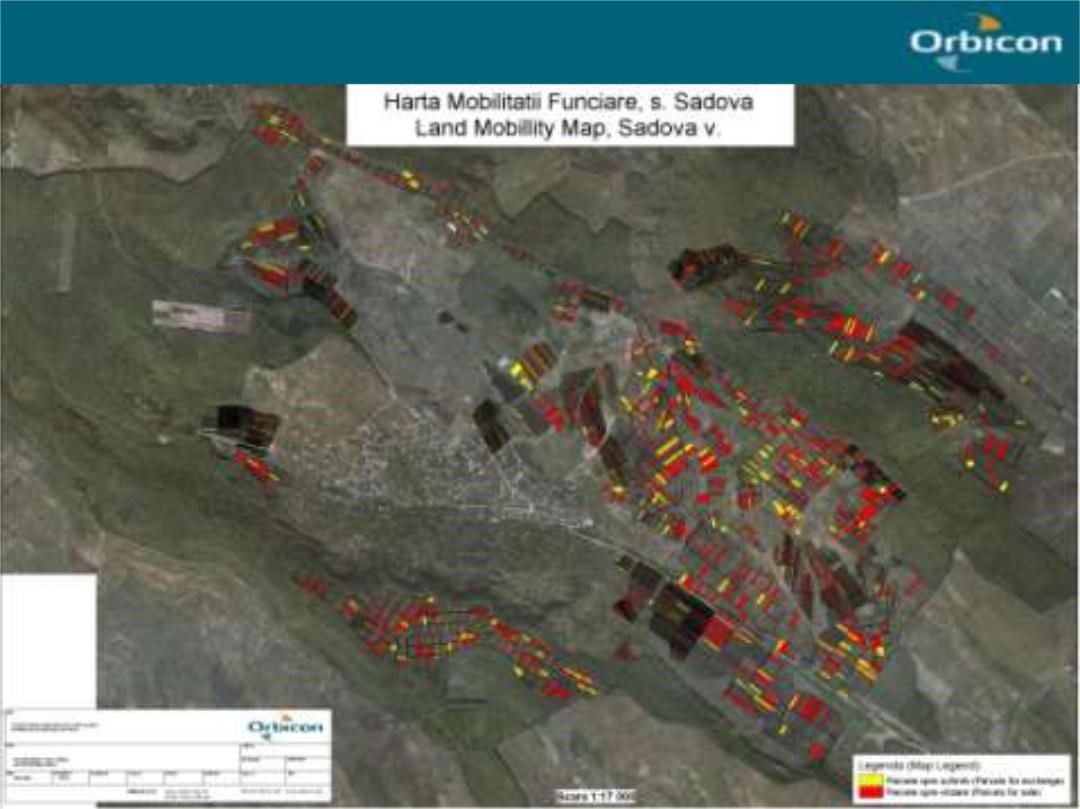
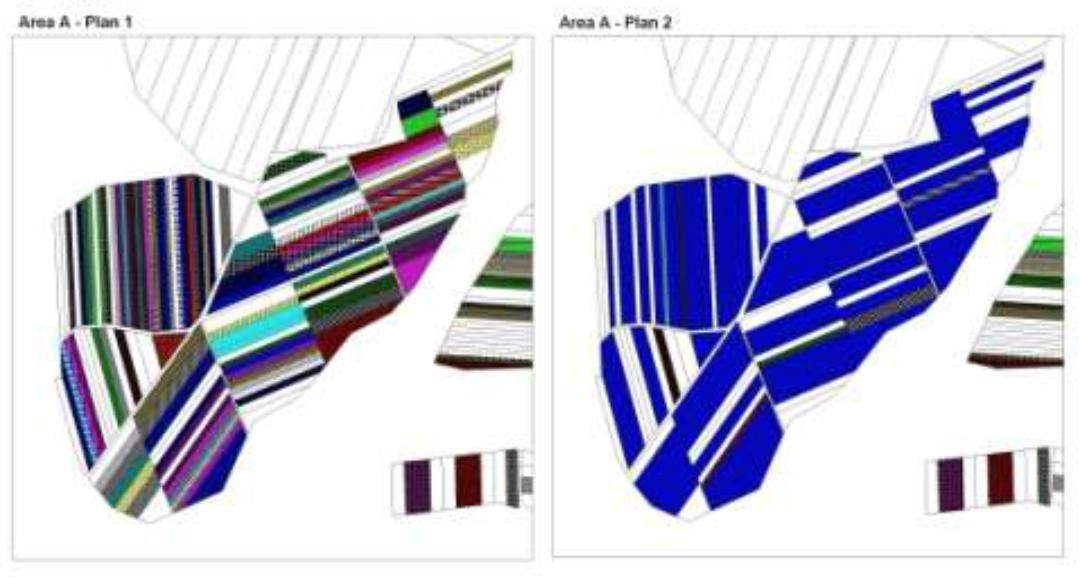
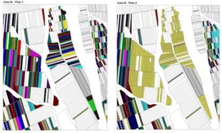
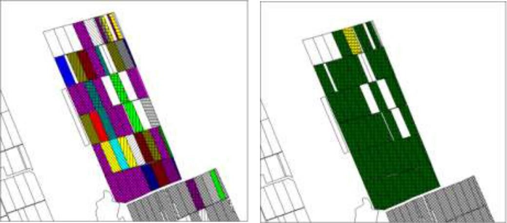
The first action implemented was agricultural land re-parcelling, based on FAO guidelines. Training programs were conducted for project staff and beneficiaries. Following land planning, discussions and individual negotiations with each land owner, the project promoted the application of the following land parcels operations: sale, exchange and long term lease. The costs incurred during land transactions were fully covered by the project. The Land Use Scheme implies changes in some categories of use and especially expanding the area of vineyards and orchards as well as using agricultural land for community development according to the needs and wishes of the population. Land re-parcelling offers farmers the possibility of rearranging agricultural land according to ecological principles and potential.
The overall goal of land re-parcelling component was to respond to the concerns of the Government and others about the fragmentation of agricultural land: it focussed on small peasant farms as its primary target group. The specific objectives of the pilot action were:
- to test the demand for and feasibility of land re-parcelling with small landowners as the primary target group;
- to facilitate development of 6 community area development plans, taking into account environmental impact assessment.
- to use the pilot experience as the basis for designing a potential national-level approach, including techniques, resource requirements and legislative framework;
- to assess the impact of re-parcelling at the local level, including on land markets, agricultural production, and equity.
The re-parcelling activities were extended to 40 villages on the proviso that the concept and the experience of the implemented re-parcelling pilots would be precisely followed. Based on this experience, the Ministry of Agriculture is in active partnership with National Agency for Rural Development and NGO BIOS, supported by the FAO-developed National Strategy for Land Consolidation.
2.3 រូបភាពនៃបច្ចេកទេស
វិចិត្រសាលប្រព័ន្ធផ្សព្វផ្សាយ
2.5 ប្រទេស/តំបន់/ទីតាំងកន្លែង ដែលបច្ចេកទេសត្រូវបានអនុវត្ត និងបានគ្រប់ដណ្តប់ដោយការវាយតម្លៃនេះ
ប្រទេស:
សាធារណរដ្ឋម៉ុលដាវី
បញ្ជាក់បន្ថែមពីលក្ខណៈនៃទីតាំង:
The six communes which form the pilot area, namely Basauca village Rezina district, Sadova village Calarasi district, Calmatui village Hincesti district, Bolduresti community of Cantemir district, Baimaclia community Cantemir district, Opaci village Causeni district, Republic of Moldova. The experience was replicated in 40 villages.
មតិយោបល់:
The six communes which form the pilot area, namely Basauca village Rezina district, Sadova village Calarasi district, Calmatui village Hincesti district, Bolduresti community of Cantemir district, Baimaclia community Cantemir district, Opaci village Causeni district, Republic of Moldova.
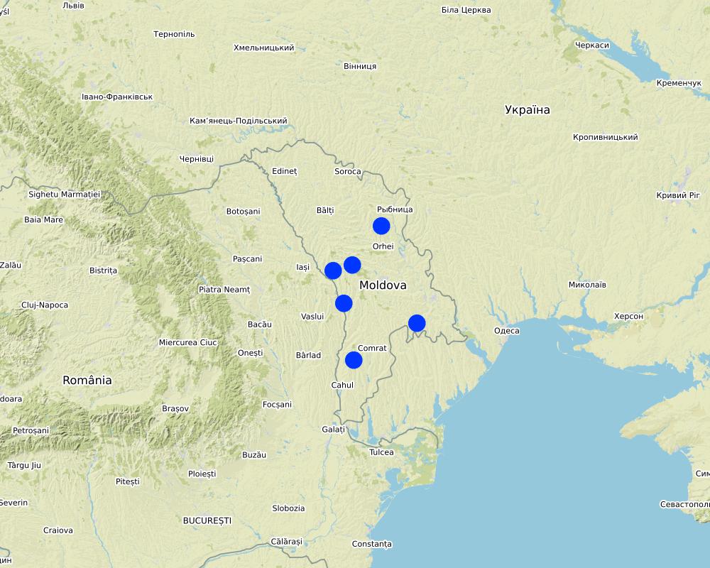
Map
×2.6 កាលបរិច្ឆេទនៃការអនុវត្ត
ប្រសិនបើមិនច្បាស់ឆ្នាំ សូមបញ្ជាក់កាលបរិច្ឆេទដែលប្រហាក់ប្រហែល:
- តិចជាង 10ឆ្នាំមុន (ថ្មី)
2.7 ការណែនាំពីបច្ចេកទេស
សូមបញ្ជាក់តើបច្ចេកទេសត្រូវបានណែនាំឱ្យអនុវត្តដោយរបៀបណា:
- ពេលកំពុងពិសោធន៍
- តាមរយៈគម្រោង / អន្តរាគមន៍ពីខាងក្រៅ
3. ចំណាត់ថ្នាក់នៃបច្ចេកទេស SLM
3.1 គោលបំណងចម្បង (១ ឬច្រើន) នៃបច្ចេកទេសនេះ
- ធ្វើឱ្យប្រសើរឡើងនូវផលិតកម្ម
- កាត់បន្ថយ, បង្ការ, ស្តារឡើងវិញនូវការធ្លាក់ចុះគុណភាពដី
- អភិរក្សប្រព័ន្ធអេកូឡូស៊ី
- ការពារតំបន់ទីជម្រាល/តំបន់ខ្សែទឹកខាងក្រោមបញ្ចូលជាមួយបច្ចេកទេសផ្សេងទៀត
- បង្កើតផលប្រយោជន៍សេដ្ឋកិច្ច
3.2 ប្រភេទដីប្រើប្រាស់មួយប្រភេទ (ច្រើនប្រភេទ) ដែលបានអនុវត្តបច្ចេកទេស

ដីដាំដំណាំ
- ដំណាំប្រចាំឆ្នាំ
- ដំណាំរយៈពេលវែង (មិនមែនឈើ)

ផ្សេងៗ
សូមបញ្ជាក់:
- Land fragmentation; - Environmentally unsustainable land management practices; - Illegal cutting of forests, leading to the destruction of forest belts and buffer strips; - Point and non-point sources of pollution, - Over-grazing..
3.3 ព័ត៌មានបន្ថែមអំពីអ្នកប្រើប្រាស់ដី
ការផ្គត់ផ្គង់ទឹកនៅកន្លែងអនុវត្តបច្ចេកទេស:
- ទឹកភ្លៀង និងប្រព័ន្ធស្រោចស្រព
ចំនួនសារដែលដាំដំណាំក្នុងមួយឆ្នាំ:
- 1
3.4 ក្រុម SLM ដែលបច្ចេកទេសស្ថិតនៅក្នុង
- ប្រព័ន្ធដំណាំបង្វិល (ការដាំដំណាំវិលជុំ ការទុកដីចោលដើម្បីបង្កើនជីជាតិ កសិកម្មពនេចរ)
- ការគ្រប់គ្រងដោយរួមបញ្ចូលការដាំដំណាំ និងការចិញ្ចឹមសត្វ
- វិធានការអនុវត្តកាត់ទទឹងទីជម្រាល
3.5 ការសាយភាយនៃបច្ចេកទេស
បញ្ជាក់ពីការសាយភាយនៃបច្ចេកទេស:
- ត្រូវបានផ្សព្វផ្សាយត្រឹមតំបន់មួយ
ប្រសិនបើបច្ចេកទេសត្រូវបានសាយភាយពាសពេញតំបន់ណាមួយ សូមកំណត់ទំហំផ្ទៃដីអនុវត្តន៍:
- > 10,000 គម2
មតិយោបល់:
The Technology was replicated to 40 villages in South, Center and North regions of Moldova
3.6 វិធានការ SLM ដែលបញ្ចូលនូវបច្ចេកទេស

វិធានការក្សេត្រសាស្ត្រ
- A1: ដំណាំ/គម្របដី
- A2: សារធាតុសរីរាង្គ/ជីជាតិដី

វិធានការរុក្ខជាតិ
- V1: ឈើធំៗ និងដើមឈើតូចៗ
- V2: ស្មៅនិងរុក្ខជាតិៗដែលដុះមានអាយុមិនលើសពី 2ឆ្នាំ

វិធានការរចនាស័ម្ពន្ធ
- S5: ទំនប់ ថ្លុក ស្រះ
- S6: ជញ្ជាំង, របាំង, របងឈើខ្ពស់ៗ
- S9: រោងដំណាំ និងរោងចិញ្ចឹមសត្វ

វិធានការគ្រប់គ្រង
- M1: ការផ្លាស់ប្តូរប្រភេទដីប្រើប្រាស់
- M2: ការផ្លាស់ប្តូរការគ្រប់គ្រង/ កម្រិតអាំងតង់ស៊ីតេ
មតិយោបល់:
- Implementing activities of protection, maintenance and improving of degraded soil fertility;
- Agroforestry consisted of planting of tree rows on cultivated lands, primarily of windbreaks and anti-erosion protective belts.
- Improving the quality of pastures and implementing controlled pasturing.|
- Regeneration of degraded commune forest as well as existing forest protective belts.
- Planting of tree rows on cultivated lands, primarily of windbreaks and anti-erosion protective belts. |
Facilitate the development of farms by reducing the fragmentation and expanding the area of agricultural lands. The project provides assistance to land owners and farmers to undertake voluntarily land transactions based on market economy principles, elaborating the land ownership maps (GIS MapInfo|
The elaboration of the Community Area Development Plans was effected together with the local public administration, professors, legal persons, non-governmental organizations, and the population of communities with active involvement of Zonal Ecologic Agencies, Preventive Medicine Centers, |Agriculture and Economy Departments of district Executive Committees.
3.7 កំណត់ប្រភេទនៃការធ្លាក់ចុះគុណភាពដីសំខាន់ៗដែលបច្ចេកទេសនេះបានដោះស្រាយ

ការហូរច្រោះដីដោយសារទឹក
- Wt: ការបាត់ដីស្រទាប់លើដោយការហូរច្រោះ
- Wr: សំណឹកដីច្រាំងទន្លេ
- Wo: ផលប៉ះពាល់នៃការធ្លាក់ចុះគុណភាពកន្លែងឆ្ងាយ

ការបាត់ដីដោយសារខ្យល់
- Et: ការបាត់បង់ដីស្រទាប់លើ
- Ed: អតិផរណា និង ការទម្លាក់

ការបាត់បង់រូបសាស្ត្រនៃដី
- Pc: ការហាប់ណែន
- Pu: បាត់បង់នូវផលិតភាពជីវៈដោយសារសកម្មភាពផ្សេងៗ

ការធ្លាក់ចុះជីវសាស្ត្រនៃដី
- Bc: ការថយចុះនូវគម្របរុក្ខជាតិ
- Bh: ការបាត់បង់ទីជំរក
- Bq: ការថយចុះនូវជីវម៉ាស/ បរិមាណ
- Bs: សមាសភាពដែលមានគុណភាពនិងប្រភេទសត្វ/ការថយចុះនូវជីវចម្រុះ
- Bl: ការបាត់បង់មីក្រូ និងម៉ាក្រូសរីរាង្គរបស់ដី
3.8 ការពារ កាត់បន្ថយ ឬស្តារឡើងវិញនៃការធ្លាក់ចុះគុណភាពដី
បញ្ជាក់ពីគោលដៅរបស់បច្ចេកទេស ដែលផ្តោតទៅការធ្លាក់ចុះគុណភាពដី:
- ការការពារការធ្លាក់ចុះគុណភាពដី
- ការកាត់បន្ថយការធ្លាក់ចុះគុណភាពដី
4. បច្ចេកទេសជាក់លាក់ សកម្មភាពអនុវត្ត ធាតុចូល និងថ្លៃដើម
4.4 សកម្មភាពបង្កើត
| សកម្មភាព | ប្រភេទវិធានការ | ពេលវេលា | |
|---|---|---|---|
| 1. | Implementing activities of protection, maintenance and improving of degraded soil fertility | ||
| 2. | Agroforestry consisting of planting of tree rows on cultivated lands, primarily of windbreaks and anti-erosion protective belts. | ||
| 3. | Improving the quality of pastures and implementing controlled pasturing| | ||
| 4. | Regeneration of degraded commune forest as well as existing forest protective belts | ||
| 5. | Planting of tree rows on cultivated lands, primarily of windbreaks and anti-erosion protective belts |
4.5 ថ្លៃដើម និងធាតុចូលដែលត្រូវការសម្រាប់ការបង្កើតបច្ចេកទេស
ប្រសិនបើអ្នកប្រើប្រាស់ដីមិនមានថ្លៃដើម 100% សូមបញ្ជាក់ថានរណាដែលចំណាយថ្លៃដើមដែលនៅសល់:
The Project
5. លក្ខណៈបរិស្ថានធម្មជាតិ និងមនុស្ស
5.1 អាកាសធាតុ
បរិមាណទឹកភ្លៀងប្រចាំឆ្នាំ
- < 250 មម
- 251-500 មម
- 501-750 មម
- 751-1,000 មម
- 1,001-1,500 មម
- 1,501-2,000 មម
- 2,001-3,000 មម
- 3,001-4,000 មម
- > 4,000 មម
បញ្ជាក់ឈ្មោះឯកសារយោងនៃស្ថានីយឧតុនិយម:
Chisinau, Nisporeni, Calarasi, Cahul, Leova, Hincesti, Rezina
តំបន់កសិអាកាសធាតុ
- មានភ្លៀងតិចតួច
Moldova's climate is moderately continental: the summers are warm and long, with temperatures averaging 20 °C, and the winters are relatively mild and dry, with January temperatures averaging −4 °C. Annual rainfall, which ranges from around 600 millimeters in the north to 400 millimeters in the south, can vary greatly. The heaviest rainfall occurs in summer; heavy showers and thunderstorms are common. Because of the irregular terrain, heavy summer rains often cause erosion and river silting.|
5.2 សណ្ឋានដី
ជម្រាលជាមធ្យម:
- រាបស្មើ (0-2%)
- ជម្រាលតិចតួច (3-5%)
- មធ្យម (6-10%)
- ជម្រាលខ្ពស់បន្តិច (11-15%)
- ទីទួល (16-30%)
- ទីទួលចោត (31-60%)
- ទីទួលចោតខ្លាំង (>60%)
ទម្រង់ដី:
- ខ្ពង់រាប
- កំពូលភ្នំ
- ជម្រាលភ្នំ
- ជម្រាលទួល
- ជម្រាលជើងភ្នំ
- បាតជ្រលងភ្នំ
តំបន់តាមរយៈកម្ពស់ :
- 0-100 ម
- 101-500 ម
- 501-1,000 ម
- 1,001-1,500 ម
- 1,501-2,000 ម
- 2,001-2,500 ម
- 2,501-3,000 ម
- 3,001-4,000 ម
- > 4,000 ម
បញ្ជាក់ថាតើបច្ចេកទេសនេះត្រូវបានអនុវត្តន៍នៅក្នុង:
- មិនពាក់ព័ន្ធទាំងអស់
មតិយោបល់ និងបញ្ចាក់បន្ថែមអំពីសណ្ឋានដី :
Most of Moldova's territory is a moderate hilly plateau cut deeply by many streams and rivers. Geologically, Moldova lies primarily on deep sedimentary rock that gives way to harder crystalline outcroppings only in the north. Moldova's hills are part of the Moldavian Plateau, which geologically originate from the Carpathian Mountains. |
5.3 ដី
ជម្រៅដីជាមធ្យម:
- រាក់ខ្លាំង (0-20 សម)
- រាក់ (21-50 សម)
- មធ្យម (51-80 សម)
- ជ្រៅ (81-120 សម)
- ជ្រៅខ្លាំង (> 120 សម)
វាយនភាពដី (ស្រទាប់លើ):
- មធ្យម (ល្បាយ, ល្បាប់)
វាយនភាពដី (> 20 សម ស្រទាប់ក្នុង):
- មធ្យម (ល្បាយ, ល្បាប់)
សារធាតុសរីរាង្គនៅស្រទាប់ដីខាងលើ:
- ខ្ពស់ (>3%)
- មធ្យម (1-3%)
បើអាចសូមភ្ជាប់ការពណ៌នាពីដីឱ្យបានច្បាស់ ឬព័ត៌មានដែលអាចទទួលបាន ឧ. ប្រភេទដី, pH ដី/ ជាតិអាស៊ីត, សមត្ថភាពផ្លាស់ប្តូរកាចុង, វត្តមាននីត្រូសែន, ភាពប្រៃ ។ល។:
About 75% of Moldova is covered by black earth or chernozem. In the northern hills, more clay textured soils are found; in the south, red-earth soil is predominant. The soil becomes less fertile toward the south but can still support grape and sunflower production. The hills have forest soils, while a small portion in southern Moldova is in the steppe zone, although most steppe areas today are cultivated. The lower reaches of the Prut and Dniester rivers and the southern river valleys are saline
5.4 ទឹកដែលអាចទាញមកប្រើប្រាស់បាន និងគុណភាពទឹក
នីវ៉ូទឹកក្រោមដី:
5-50 ម
ទឹកលើដីដែលអាចទាញយកប្រើប្រាស់បាន:
កម្រិតមធ្យម
គុណភាពទឹក (មិនបានធ្វើប្រត្តិកម្ម):
ទឹកពិសារដែលគ្មានគុណភាព (តម្រូវឱ្យមានការសំអាត)
តើមានបញ្ហាភាពទឹកប្រៃហូរចូលមកដែរឬទេ?
បាទ/ចា៎
សូមបញ្ជាក់:
high water mineralisation
តើទឹកជំនន់កំពុងកើតមាននៅតំបន់នេះដែររឺទេ?
បាទ/ចា៎
ភាពទៀងទាត់:
ម្តងម្កាល
5.5 ជីវៈចម្រុះ
ភាពសម្បូរបែបនៃប្រភេទ:
- កម្រិតមធ្យម
ភាពសម្បូរបែបនៃទីជម្រក:
- ទាប
5.6 លក្ខណៈនៃអ្នកប្រើប្រាស់ដីដែលអនុវត្តបច្ចេកទេស
នៅមួយកន្លែង ឬពនេចរ :
- នៅមួយកន្លែង
ទីផ្សារនៃប្រព័ន្ធផលិតកម្ម:
- ពាក់កណ្តាលពាណិជ្ជកម្ម (ផ្គត់ផ្គង់ខ្លួនឯង/ ពាណិជ្ជកម្ម
ចំណូលក្រៅកសិកម្ម:
- 10-50% នៃចំណូល
កម្រិតជីវភាព:
- មិនល្អ
ឯកជន ឬក្រុម:
- ធ្វើខ្លួនឯង/ គ្រួសារ
- ជាក្រុម/ សហគមន៍
កម្រិតប្រើប្រាស់គ្រឿងយន្ត:
- គ្រឿងយន្ត/ ម៉ាស៊ីន
យេនឌ័រ:
- ស្ត្រី
- បុរស
អាយុរបស់អ្នកប្រើប្រាស់ដី:
- វ័យកណ្តាល
- មនុស្សចាស់
5.7 ទំហំផ្ទៃដីជាមធ្យមនៃដីផ្ទាល់ខ្លួន ឬជួលគេដែលបានអនុវត្តបច្ចេកទេស
- < 0.5 ហិកតា
- 0.5-1 ហិកតា
- 1-2 ហិកតា
- 2-5 ហិកតា
- 5-15 ហិកតា
- 15-50 ហិកតា
- 50-100 ហិកតា
- 100-500 ហិកតា
- 500-1,000 ហិកតា
- 1,000-10,000 ហិកតា
- > 10,000 ហិកតា
តើផ្ទៃដីនេះចាត់ទុកជាទំហំកម្រិតណាដែរ ខ្នាតតូច មធ្យម ឬខ្នាតធំ (ធៀបនឹងបរិបទតំបន់)?
- ខ្នាតតូច
មតិយោបល់:
After independence (1991), land was privatized. The average family was entitled to plots of between 1.5 and 2.5 ha. Four categories of farms emerged: (i) small individual farmers; (ii) individual commercial farmers; (iii) farmers in associations with close relatives; and (iv) farmers in groups (from less than 10 farmers to large, joint-stock companies). The small size of many farms precludes the use of agricultural machinery and advanced technology. |
5.8 ភាពជាម្ចាស់ដី កម្មសិទ្ធប្រើប្រាស់ដី និងកម្មសិទ្ធប្រើប្រាស់ទឹក
ភាពជាម្ចាស់ដី:
- ភូមិ
- ឯកជន មានកម្មសិទ្ធ
កម្មសិទ្ធិប្រើប្រាស់ដី:
- កិច្ចសន្យាជួល
- ឯកជន
កម្មសិទ្ធប្រើប្រាស់ទឹក:
- អាស្រ័យផលសេរី (មិនមានការកំណត់)
- ឯកជន
មតិយោបល់:
The principal activity of local farmers is crop farming; main arable crops are maize and wheat. The cultivation of grapes and fruits is another traditional element of agriculture in this area. Vineyards and orchards take a significant share of cropped land. Income is derived from sale of agricultural produce, including milk and eggs, from forest products, but also from seasonal work at the small workshops in their own and surrounding communities.|
Income depends much on weather conditions and agricultural policies. Estimated average income per person is 50 US dollars per month for the last three years (no including this year).
5.9 ការប្រើប្រាស់សេវាកម្ម និងហេដ្ឋារចនាសម្ព័ន្ធ
សុខភាព:
- មិនល្អ
- មធ្យម
- ល្អ
ការអប់រំ:
- មិនល្អ
- មធ្យម
- ល្អ
ជំនួយបច្ចេកទេស:
- មិនល្អ
- មធ្យម
- ល្អ
ការងារ (ឧ. ការងារក្រៅកសិដ្ឋាន):
- មិនល្អ
- មធ្យម
- ល្អ
ទីផ្សារ:
- មិនល្អ
- មធ្យម
- ល្អ
ថាមពល:
- មិនល្អ
- មធ្យម
- ល្អ
ផ្លូវ និងការដឹកជញ្ជូន:
- មិនល្អ
- មធ្យម
- ល្អ
ទឹកផឹក និងអនាម័យ:
- មិនល្អ
- មធ្យម
- ល្អ
សេវាកម្មហិរញ្ញវត្ថុ:
- មិនល្អ
- មធ្យម
- ល្អ
6. ផលប៉ះពាល់ និងការសន្និដ្ឋាន
6.1 ផលប៉ះពាល់ក្នុងបរិវេណអនុវត្តបច្ចេកទេសដែលកើតមាន
ផលប៉ះពាល់លើសេដ្ឋកិច្ចសង្គម
ផលិតផល
ផលិតកម្មដំណាំ
ផលិតកម្មសត្វ
គុណភាពព្រៃឈើ/ដីព្រៃ
ភាពសម្បូរបែបនៃផលិតផល
ផ្ទៃដីផលិតកម្ម
ការគ្រប់គ្រងដី
ទឹកដែលអាចទាញមកប្រើប្រាស់បាន និងគុណភាពទឹក
ទឹកបរិភោគដែលអាចទាញយកមកប្រើប្រាស់បាន
គុណភាពទឹកបរិភោគ
ទឹកដែលអាចប្រើប្រាស់បានសម្រាប់ការចិញ្ចឹមសត្វ
ចំណូល និងថ្លៃដើម
ចំណូលក្នុងកសិដ្ឋាន
ភាពសម្បូរបែបប្រភពប្រាក់ចំណូល
ផលប៉ះពាល់ទៅលើអេកូឡូស៊ី
វដ្តទឹក/លំហូរ
ការប្រមូលស្តុកទុកទឹក
លំហូរទឹកលើផ្ទៃដី
ដី
សំណើមដី
គម្របដី
ការបាត់បង់ដី
ដីប្រេះ
ដីហាប់
សារធាតុសរីរាង្គដី/ការបូនក្រោមដី
ជីវចម្រុះ៖ ដំណាំ, សត្វ
ដំណាំគម្រប
ជីវម៉ាស/ កាបូនលើដី
ភាពសម្បូរបែបនៃរុក្ខជាតិ
ភាពសម្បូរបែបនៃសត្វ
ភាពសម្បូរបែបនៃទីជំរក
6.2 ផលប៉ះពាល់ក្រៅបរិវេណអនុវត្តបច្ចេកទេសដែលកើតមាន
ទឹកជំនន់ខ្សែទឹកខាងក្រោម
កំណកល្បាប់ខ្សែទឹកខាងក្រោម
ទឹកក្រោមដី/ ការបំពុលទឹកទន្លេ
Buffering/សមត្ថភាពចម្រោះ
ខូចខាតដល់ស្រែអ្នកជិតខាង
6.3 ភាពប្រឈម និងភាពរួសនៃបច្ចេកទេសទៅនឹងការប្រែប្រួលអាកាសធាតុ និងគ្រោះអាកាសធាតុ/ គ្រោះមហន្តរាយ (ដែលដឹងដោយអ្នកប្រើប្រាស់ដី)
មតិយោបល់:
Expected changes include utilization of local resources, change in existing land use management, change in landscape, changes in erosion rates, etc. These in their turn are expected to lead to social and economic impacts on people.
• The main environmental indicators are largely the same. • The expected environmental impact of re-parcelling and initiated actions are significant, especially in the long run. |
People learn to live with the new approach, new land structure, alternative solutions of solving their own problems, etc. |
Implementation of the land re-parcelling project contributes to improving the structure of the agricultural land, efficient use of technology, increase the possibility of arranging the community territory with a consolidated network of roads; |
The economic levels stayed practically unchanged, while social cohesion and culture has somewhat improved from exposure to new things, common work. The expected social impact of re-parcelling and initiated actions are significant, especially in the long run.|
Expected changes include increased jobs for people, there will be favourable conditions for the young population to stay in the rural area and those who left abroad could return back and start various businesses in their village.|
Improving the community infrastructure by water and natural gas supply, etc. It offers farmers a possibility to start processing enterprises so that they can sell the final product at a higher price than the raw products.
6.4 ការវិភាគថ្លៃដើម និងអត្ថប្រយោជន៍
តើផលចំណេញ និងថ្លៃដើមត្រូវបានប្រៀបធៀបគ្នាយ៉ាងដូចម្តេច (ទស្សនៈរបស់អ្នកប្រើប្រាស់ដី)?
រយៈពេលខ្លី:
វិជ្ជមានតិចតួច
រយៈពេលវែង:
វិជ្ជមាន
តើផលចំណេញ និងការថែទាំ/ ជួសជុលត្រូវបានប្រៀបធៀបគ្នាយ៉ាងដូចម្តេច (ទស្សនៈរបស់អ្នកប្រើប្រាស់ដី)?
រយៈពេលខ្លី:
វិជ្ជមានតិចតួច
រយៈពេលវែង:
វិជ្ជមាន
6.5 ការទទួលយកបច្ចេកទេស
- 10-50%
ក្នុងចំណោមគ្រួសារទាំងអស់ដែលអនុវត្តបច្ចេកទេស តើមានប៉ុន្មានគ្រួសារដែលចង់ធ្វើដោយខ្លួនឯង ដោយមិនទទួលបានសម្ភារៈលើកទឹកចិត្ត/ប្រាក់ឧបត្ថម្ភ?:
- 10-50%
6.6 ការបន្សុំា
តើថ្មីៗនេះ បច្ចេកទេសនេះត្រូវបានកែតម្រូវដើម្បីបន្ស៊ាំទៅនឹងស្ថានភាពប្រែប្រួលដែរឬទេ?
ទេ
6.7 ភាពខ្លាំង/ គុណសម្បត្តិ/ ឱកាសនៃបច្ចេកទេស
| ភាពខ្លាំង/ គុណសម្បត្តិ/ ឱកាស ទស្សនៈរបស់បុគ្គលសំខាន់ៗ |
|---|
|
Business opportunities related to community development, etc. | Highly motivated local governments Highly motivated farmers |
7. ឯកសារយោង និងវេបសាយ
7.1 វិធីសាស្ត្រ/ ប្រភពនៃព័ត៌មាន
- ការសម្ភាសន៍ជាមួយអ្នកប្រើប្រាស់ដី
6000
7.3 ចូលទៅទាញយកឯកសារដែលពាក់ព័ន្ធតាមបណ្តាញអ៊ិនធឺណែត
ចំណងជើង/ ពណ៌នា:
Assessment Study on Land Re-parceling Pilot Project in 6 Villages in Moldova
វេបសាយ:
http://www.capmu.md/wp-content/uploads/images/docs/Impact_Assessment/Final%20report%20IA%20land%20rep.pdf
ចំណងជើង/ ពណ៌នា:
Experiences with land reform and land consolidation in Moldova
វេបសាយ:
file:///C:/Users/USER/Downloads/59-357-1-PB.pdf
ការតភ្ជាប់ និងម៉ូឌុល
ពង្រីកមើលទាំងអស់ បង្រួមទាំងអស់ការតភ្ជាប់
គ្មានការតភ្ជាប់
ម៉ូឌុល
គ្មានម៉ូឌុល