Dawa-Cheffa Traditional Checkdam [Etiopía]
- Creación:
- Actualización:
- Compilador: Unknown User
- Editor: –
- Revisores: Fabian Ottiger, Alexandra Gavilano
Kiter
technologies_1058 - Etiopía
Visualizar secciones
Expandir todo Colapsar todos1. Información general
1.2 Detalles de contacto de las personas de referencia e instituciones involucradas en la evaluación y la documentación de la Tecnología
Persona(s) de referencia clave
Especialista MST:
Umer Kemal
Dewa Chefe Woreda Agriculture and Rural Development Office (DWARAO)
Etiopía
Nombre de la(s) institución(es) que facilitaron la documentación/ evaluación de la Tecnología (si fuera relevante)
Ministry of Agriculture and Rural Development of Ethiopia (Ministry of Agriculture and Rural Development) - Etiopía1.3 Condiciones referidas al uso de datos documentados mediante WOCAT
El compilador y la/s persona(s) de referencia claves aceptan las condiciones acerca del uso de los datos documentados mediante WOCAT:
Sí
2. Descripción de la Tecnología MST
2.1 Breve descripción de la Tecnología
Definición de la Tecnología:
A structural measure constructed by stone/soil/wood acrross the gully to control erosion and create favourble condition for crop cultivation.
2.2 Descripción detallada de la Tecnología
Descripción:
The technology is known by the farmers for more than a century. Since the area is highly affected by gully erosion, this practice is widely used by farmers in the area and also widely practiced. Its construction starts from the bottom of the gully and proceeds upslope with different dimensions. The height depends on the depth of the gully and it is increased from year to year. On the average the width is 1m and hieght is 1.80m. The technology is used to develop big gullies and treatment of small gully like depressions, attain slope change to enhance land suitability to crop production and to conserve soil and water. The construction of the stone checkdam starts with small heights and some height is added every year until the intended height is reached. The increase in height could be done during maintenance also. The major objective being to stop gully growth, trap sediment and retain water running down the gully. In the course of increasing the height, the area for sediment deposition gets wider. The technology is suitable to areas with low rainfalls of rugged topography having a network of gullies.
2.5 País/ región/ lugares donde la Tecnología fue aplicada y que se hallan comprendidos por esta evaluación
País:
Etiopía
Región/ Estado/ Provincia:
Amhara Regional State
Especifique más el lugar :
Koshem Watershed
Especifique la difusión de la Tecnología:
- distribuida parejamente sobre un área
Si se desconoce el área precisa, indique el área aproximada cubierta:
- 10-100 km2
Comentarios:
Total area covered by the SLM Technology is 810 km2.
The technology is mostly practiced in the eastern escarpment of the the woreda experiencing low and erratic rains. Area is estimated
Map
×2.6 Fecha de la implementación
Si no se conoce el año preciso, indique la fecha aproximada:
- hace más de 50 años atrás (tradicional)
2.7 Introducción de la Tecnología
Especifique cómo se introdujo la Tecnología:
- como parte de un sistema tradicional (> 50 años)
Comentarios (tipo de proyecto, etc.):
Is developed by land users themselves
3. Clasificación de la Tecnología MST
3.1 Propósito(s) principal(es) de la Tecnología MST
- mejorar la producción
- reducir, prevenir, restaurar la degradación de la tierra
3.2 Tipo(s) actuales de uso de la tierra donde se aplica la Tecnología

Tierras cultivadas
- Cosecha anual
- Cultivos perennes (no leñosos)
- Cosecha de árboles y arbustos
Cosechas anuales - Especifique cultivos:
- cereales - maíz
- cereales - sorgo
- leguminosas y legumbres - frijoles
- leguminosas y legumbres - otros
- cultivos de semillas oleaginosas - girasol, colza, otros
- haricot bean, teff
- sugar cane, elephant grass, local grass
Cultivos de matorrales y arbustos - Especifique cultivos:
- cítricos
- café, cultivado al aire libre
- frutas, otros
- mango, mangostán, guayaba
- papaya
- acacia, eucalyptus, khata edulis, ageava sisal, banana, lemon
Número de temporadas de cultivo por año:
- 2
Especifique:
Longest growing period in days: 210 Longest growing period from month to month: May - Nov Second longest growing period in days: 180 Second longest growing period from month to month: Jan - Apr
¿Se practica el intercultivo?
Sí
Si respondió que sí, especifique qué cultivos son intercultivados:
sorghum/maize +haricot beans

Tierra de pastoreo

Bosques
- Bosques/ zonas boscosas (semi) naturales
Bosques/ zonas boscosas (semi-) naturales: Especifique tipo de manejo:
- Tala clara
Productos y servicios:
- Madera
- Leña
- Pastoreo/ ramoneo
Comentarios:
Major land use problems (compiler’s opinion): Increase in human and animal population, overggrazing and expansion of cultivated lands to areas which are not suitable to cultivation is a problem. Meanwhile, owing to gully expansion and in the absence of preventive and control measures, there is considerable loss of soil from grazing and cultivated lands.
Major land use problems (land users’ perception): More area is getting out of production.
Other grazingland: extensive: pastoralism: in the eastern side of the SWC technology area
Other grazingland: extensive: semi-pastoralism: on the ridgea nd hilly slopes where land users are engaged in crop and livestock production
Grazingland comments: Livestock production is decreasing primarily because of decreasing grazing lands. The number of livestock being the most important factor for herd owners than the quailty. More extension work will be needed to promot the awarness of livestock owners in a way they give emphases to quality of livestock production than numbers.
Clear felling of (semi-)natural forests: to open land for cultivation, chrcoal making
Problems / comments regarding forest use: The natural forest/wood lands are decreasing mainly to expansion of cultivation and also due to high demand for use. However, because of plantations on gullies, hillside closures and woodlots there is a positive trend of increase of planted trees.
Type of cropping system and major crops comments: Fruit trees, sugar cane, pulses
Type of grazing system comments: Livestock production is decreasing primarily because of decreasing grazing lands. The number of livestock being the most important factor for herd owners than the quailty. More extension work will be needed to promot the awarness of livestock owners in a way they give emphases to quality of livestock production than numbers.
3.4 Provisión de agua
Provisión de agua para la tierra donde se aplica la Tecnología:
- de secano
Comentarios:
Water supply: Also mixed rainfed - irrigated
Water supply: post-flooding
3.5 Grupo MST al que pertenece la Tecnología
- manejo de agua superficial (manantial, río, lagos, mar):
3.6 Medidas MST que componen la Tecnología

medidas agronómicas
- A1: vegetación/ cubierta del suelo
- A2: materia orgánica/ fertilidad del suelo
- A3: Tratamiento de superficie del suelo
- A6: Manejo de residuos
- A7: Otros

medidas vegetativas

medidas estructurales
- S6: Muros, barreras, vallas, cercas
Comentarios:
Main measures: structural measures
Secondary measures: agronomic measures, vegetative measures
Type of agronomic measures: mixed cropping / intercropping, contour planting / strip cropping, legume inter-planting, manure / compost / residues, contour tillage
Type of vegetative measures: aligned: -contour
3.7 Principales tipos de degradación de la tierra encarados con la Tecnología

erosión de suelos por agua
- Wt: pérdida de capa arable/ erosión de la superficie
- Wg: erosión en cárcavas

deterioro químico del suelo
- Cn: reducción de la fertilidad y contenido reducido de la materia orgánica del suelo (no ocasionados por la erosión)
Comentarios:
Main type of degradation addressed: Wg: gully erosion / gullying
Secondary types of degradation addressed: Wt: loss of topsoil / surface erosion, Cn: fertility decline and reduced organic matter content
Main causes of degradation: deforestation / removal of natural vegetation (incl. forest fires), overgrazing, other human induced causes (specify) (agricultural causes), labour availability (lack of labour), land subdivision
Secondary causes of degradation: over-exploitation of vegetation for domestic use, other natural causes (avalanches, volcanic eruptions, mud flows, highly susceptible natural resources, extreme topography, etc.) specify, poverty / wealth (lack of captial), education, access to knowledge and support services (lack of knowledge), lack of enforcement of legislat./authority
3.8 Prevención, reducción o restauración de la degradación de la tierra
Especifique la meta de la Tecnología con relación a la degradación de la tierra:
- restaurar/ rehabilitar tierra severamente degradada
Comentarios:
Secondary goals: prevention of land degradation, mitigation / reduction of land degradation
4. Especificaciones técnicas, actividades de implementación, insumos y costos
4.1 Dibujo técnico de la Tecnología
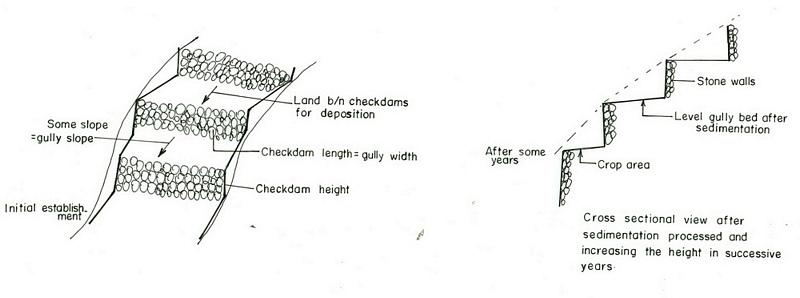
Especificaciones técnicas (relacionadas al dibujo técnico):
Amhara
Technical knowledge required for field staff / advisors: high
Technical knowledge required for land users: moderate
Main technical functions: increase / maintain water stored in soil, sediment retention / trapping, sediment harvesting
Secondary technical functions: reduction of slope angle, reduction of slope length, increase of infiltration
Mixed cropping / intercropping
Material/ species: sorghum/maize +haricot beans
Quantity/ density: 70,000 sor
Remarks: broadcast
Agronomic measure: mixed cropping / intercropping
Material/ species: teff + sunflower
Quantity/ density: -
Remarks: broadcast
Manure / compost / residues
Material/ species: Animal dung, fuelwood ash, leaves, soil
Quantity/ density: 0.6 ton/ha
Contour tillage
Remarks: along contour
Agronomic measure: Sediment trapped by checkdam
Remarks: along the contour
Agronomic measure: Seedbed preparation by hoe
Aligned: -contour
Vegetative material: T : trees / shrubs
Number of plants per (ha): 1500
Vertical interval between rows / strips / blocks (m): 1-1.8m
Spacing between rows / strips / blocks (m): 8-10m
Vertical interval within rows / strips / blocks (m): 1-2m
Width within rows / strips / blocks (m): 1x1
Vegetative measure: aligned: contour
Vegetative material: G : grass
Number of plants per (ha): -
Vertical interval between rows / strips / blocks (m): 1-1.8m
Spacing between rows / strips / blocks (m): 8-10m
Vertical interval within rows / strips / blocks (m): -
Width within rows / strips / blocks (m): -
Vegetative measure: aligned: contour
Vegetative material: G : grass
Number of plants per (ha): 2000
Vertical interval between rows / strips / blocks (m): 1-1.8m
Spacing between rows / strips / blocks (m): 8-10m
Vertical interval within rows / strips / blocks (m): -
Width within rows / strips / blocks (m): -
Vegetative measure: Vegetative material: G : grass
Vegetative measure: Vegetative material: G : grass
Trees/ shrubs species: acacia, eucalyptus, khata edulis, ageava sisal
Fruit trees / shrubs species: coffee, papaya, guava, banana, lemon, manago, orange
Grass species: elephant grass, local grass
Slope (which determines the spacing indicated above): 12.00%
If the original slope has changed as a result of the Technology, the slope today is (see figure below): 3.00%
Gradient along the rows / strips: 0.00%
Structural measure: Checkdam
Vertical interval between structures (m): 1
Spacing between structures (m): 8m
Depth of ditches/pits/dams (m): 0.3m
Width of ditches/pits/dams (m): 1m
Length of ditches/pits/dams (m): 5m
Height of bunds/banks/others (m): 0.5-1m
Width of bunds/banks/others (m): 1m
Length of bunds/banks/others (m): 5.m
Construction material (earth): Soil is embnked upslope of the stone wall as reinforcement
Construction material (stone): Stone is used to construct the embankment/wall/and is supported by soil in the upslope side to reinf
Construction material (wood): Wood used as support at the downslope side
Slope (which determines the spacing indicated above): 12%
If the original slope has changed as a result of the Technology, the slope today is: 3%
Lateral gradient along the structure: 0%
For water harvesting: the ratio between the area where the harvested water is applied and the total area from which water is collected is: 1:3
Vegetation is used for stabilisation of structures.
Change of land use type: gully converted to cropland
Other type of management: fencing and guarding - protect animals from interering to plantations
4.2 Información general sobre el cálculo de insumos y costos
otra / moneda nacional (especifique):
Birr
Si fuera relevante, indique la tasa de cambio de dólares americanos a la moneda local (ej. 1 U$ = 79.9 Reales Brasileros): 1 U$ =:
8,6
Indique el costo promedio del salario de trabajo contratado por día:
0.70
4.3 Actividades de establecimiento
| Actividad | Momento (estación) | |
|---|---|---|
| 1. | Seedling production | March to June |
| 2. | Planting | June to July |
| 3. | Excavation | dry season |
| 4. | Stone collection | dry season |
| 5. | Construction | dry season |
| 6. | Fencing | after plantation |
4.4 Costos e insumos necesarios para el establecimiento
| Especifique insumo | Unidad | Cantidad | Costos por unidad | Costos totales por insumo | % de los costos cubiertos por los usuarios de las tierras | |
|---|---|---|---|---|---|---|
| Mano de obra | Labour | ha | 1,0 | 4625,0 | 4625,0 | 90,0 |
| Equipo | Tools | ha | 1,0 | 120,0 | 120,0 | 95,0 |
| Material de construcción | Stone | ha | 1,0 | 100,0 | ||
| Costos totales para establecer la Tecnología | 4745,0 | |||||
| Costos totales para establecer la Tecnología en USD | 551,74 | |||||
Comentarios:
Duration of establishment phase: 180 month(s)
4.5 Actividades de establecimiento/ recurrentes
| Actividad | Momento/ frequencia | |
|---|---|---|
| 1. | clean crop residue | Early January / |
| 2. | primary digging | Feb-March / |
| 3. | harrowing | March / |
| 4. | manure application | March / |
| 5. | planting | April / |
| 6. | weeding and cultivation | Late June-August / |
| 7. | harvest | November-December / |
| 8. | replanting | during rains /once a year |
| 9. | pruning and thining | dry season /once a year |
| 10. | Stone collection | dry season/once a year |
| 11. | Placing the stones where maintenance is required | dry season/once a year |
| 12. | repairing breaks in fences | before replanting / annual |
4.6 Costos e insumos necesarios para actividades de mantenimiento/ recurrentes (por año)
| Especifique insumo | Unidad | Cantidad | Costos por unidad | Costos totales por insumo | % de los costos cubiertos por los usuarios de las tierras | |
|---|---|---|---|---|---|---|
| Mano de obra | Labour | ha | 1,0 | 624,0 | 624,0 | 100,0 |
| Equipo | Tools | ha | 1,0 | 30,0 | 30,0 | 100,0 |
| Material de construcción | Stone | ha | 1,0 | 100,0 | ||
| Indique los costos totales para mantenecer la Tecnología | 654,0 | |||||
| Costos totales para mantener la Tecnología en USD | 76,05 | |||||
Comentarios:
Machinery/ tools: Shovel, hoe
Length per hectar of land
4.7 Factores más determinantes que afectan los costos:
Describa los factores más determinantes que afectan los costos:
labour, slope and depth of the gully, width of the gully, availability of construction material, soil depth. The establishment cost considerts the cost incurred over 15 years.
5. Entorno natural y humano
5.1 Clima
Lluvia anual
- < 250 mm
- 251-500 mm
- 501-750 mm
- 751-1,000 mm
- 1,001-1,500 mm
- 1,501-2,000 mm
- 2,001-3,000 mm
- 3,001-4,000 mm
- > 4,000 mm
Especificaciones/ comentarios sobre la cantidad de lluvia:
Specification 500-750 mm (600mm)
Specification 750-1000 mm (900mm)
Zona agroclimática
- Sub-húmeda
- semi-árida
Semi-arid: In the SWC area the semiarid part is about 70%
Sub-humid: Comprises about 30%
5.2 Topografía
Pendientes en promedio:
- plana (0-2 %)
- ligera (3-5%)
- moderada (6-10%)
- ondulada (11-15%)
- accidentada (16-30%)
- empinada (31-60%)
- muy empinada (>60%)
Formaciones telúricas:
- meseta/ planicies
- cordilleras
- laderas montañosas
- laderas de cerro
- pies de monte
- fondo del valle
Zona altitudinal:
- 0-100 m s.n.m.
- 101-500 m s.n.m.
- 501-1,000 m s.n.m
- 1,001-1,500 m s.n.m
- 1,501-2,000 m s.n.m
- 2,001-2,500 m s.n.m
- 2,501-3,000 m s.n.m
- 3,001-4,000 m s.n.m
- > 4,000 m s.n.m
Comentarios y especificaciones adicionales sobre topografía :
Landforms: Hill slopes (ranked 1, relatively drier and the technology is most suitable to this area) and ridges (ranked 2, the ridge separates the east and west parts the SWC area)
Slopes on average: Hilly (ranked 1, mostly terraced of stone bunds), rolling (ranked 2, more number of gullies and more area under the technology) and steep (ranked 3, bush lands suitable for grazing)
5.3 Suelos
Profundidad promedio del suelo:
- muy superficial (0-20 cm)
- superficial (21-50 cm)
- moderadamente profunda (51-80 cm)
- profunda (81-120 cm)
- muy profunda (>120 cm)
Textura del suelo (capa arable):
- áspera/ ligera (arenosa)
- mediana (limosa)
Materia orgánica de capa arable:
- baja (<1%)
Si se halla disponible, adjunte una descripción completa de los suelos o especifique la información disponible, por ej., tipo de suelo, pH/ acidez de suelo, capacidad de intercambio catiónico, nitrógeno, salinidad, etc. :
Soil depth on average: Shallow (ranked1, more on hill slopes), moderately deep (ranked 2, on rolling terrain) and very shallow (ranked 3, on hilly and steep slopes)
Soil texture: Medium (dominant on hilly slopes) and coarse/light (on rolling terrains)
Soil fertility is low (on hilly sloping areas) and medium (on rolling lands)
Topsoil organic matter: Low (in all land forms)
Soil drainage/infiltration is good (on hilly and rolling lands) and medium (ridge)
Soil water storage capacity is low (on hilly and rolling lands) and medium (ridge)
5.6 Las características de los usuarios de la tierra que aplican la Tecnología
Orientación del mercado del sistema de producción:
- subsistencia (autoprovisionamiento)
- mixta (subsistencia/ comercial)
Ingresos no agrarios:
- menos del 10% de todos los ingresos
Nivel relativo de riqueza:
- pobre
- promedio
Nivel de mecanización:
- trabajo manual
- tracción animal
Indique otras características relevantes de los usuarios de las tierras:
Population density: 50-100 persons/km2
Annual population growth: 2% - 3%
20% of the land users are rich and own 30% of the land.
35% of the land users are average wealthy and own 30% of the land.
45% of the land users are poor and own 40% of the land.
Market orientation of garzing land production system: Subsistence (self-supply, production ids for self consumption and even it does not satistfy household needs)
Market orientation of crop land production system: Subsistence (self-supply) and mixed (subsistence and commercial)
Market orientation of crop land production system: Subsistence (self-supply, fuel wood collection for home consumption , construction wood, sell fuel woo and , make charcoal )
5.7 Área promedio de la tierra usada por usuarios de tierra que aplican la Tecnología
- < 0.5 ha
- 0.5-1 ha
- 1-2 ha
- 2-5 ha
- 5-15 ha
- 15-50 ha
- 50-100 ha
- 100-500 ha
- 500-1,000 ha
- 1,000-10,000 ha
- > 10,000 ha
5.8 Tenencia de tierra, uso de tierra y derechos de uso de agua
Tenencia de tierra:
- estado
Derechos de uso de tierra:
- individual
6. Impactos y comentarios para concluir
6.1 Impactos in situ demostrados por la Tecnología
Impactos socioeconómicos
Producción
producción de cultivo
Comentarios/ especifique:
The cost benefit anlysis for sorghum shows negative profit but for other crops such as combination of coffe, papaya, chat the profit is high
producción de forraje
calidad de forraje
Ingreso y costos
ingreso agrario
Comentarios/ especifique:
for cropping patterns which consider field crops + cash crops is high
Impactos socioculturales
MST/ conocimiento de la degradación de la tierra
Impactos ecológicos
Ciclo de agua/ escurrimiento de sedimento
escurrimiento superficial
Cantidad antes de MST:
70
Cantidad luego de MST:
5
Suelo
humedad del suelo
Comentarios/ especifique:
soil depth increased by depostion infiltration enhanced
cubierta del suelo
Comentarios/ especifique:
plantations
pérdida de suelo
Cantidad antes de MST:
10
Cantidad luego de MST:
0
Comentarios/ especifique:
checdams decrease gully slope
Otros impactos ecológicos
Soil fertility
Comentarios/ especifique:
Fertile top soil erdoed upslope is trapped in the gully
Biodiversity
Comentarios/ especifique:
combined application of useful plants and crop
6.2 Impactos fuera del sitio demostrados por la Tecnología
corriente confiable y estable fluye en estación seca
Comentarios/ especifique:
high percolation rate of rain water
inundaciones río abajo
Comentarios/ especifique:
runoff is trapped by supportive technologies undertaken in the upper catchment and runoof velocity retarded by checkdams
colmatación río abajo
Comentarios/ especifique:
sediment trapped in the gullies
6.4 Análisis costo-beneficio
¿Cómo se comparan los beneficios con los costos de establecimiento (desde la perspectiva de los usuarios de tierra)?
Ingresos a corto plazo:
negativo
Ingresos a largo plazo:
positivo
¿Cómo se comparan los beneficios con los costos de mantenimiento/ recurrentes (desde la perspectiva de los usuarios de tierra)?
Ingresos a corto plazo:
ligeramente negativo
Ingresos a largo plazo:
positivo
6.5 Adopción de la Tecnología
Si tiene la información disponible, cuantifique (número de hogares y/o área cubierta):
25000
De todos quienes adoptaron la Tecnología, ¿cuántos lo hicieron espontáneamente, por ej. sin recibir nada de incentivos/ materiales:
- 91-100%
Comentarios:
25000 land user families have adopted the Technology with external material support
Comments on acceptance with external material support: estimates
100% of land user families have adopted the Technology without any external material support
25000 land user families have adopted the Technology without any external material support
Comments on spontaneous adoption: estimates
There is a little trend towards spontaneous adoption of the Technology
Comments on adoption trend: Reclaiming gullies for agricultural land (crop and livestock production) is labourous.
6.7 Fuerzas/ ventajas/ oportunidades de la Tecnología
| Fuerzas/ ventajas/ oportunidades desde la perspectiva del usuario de la tierra |
|---|
|
Land reclaimed How can they be sustained / enhanced? fertility of soils increased by accumulated top soil from other area. |
|
retain moisture How can they be sustained / enhanced? water stored in the soil. |
| Fuerzas/ ventajas/ oportunidades desde la perspectiva del compilador o de otra persona de referencia clave |
|---|
|
Reduce runoff speed How can they be sustained / enhanced? exercise frequent maintenance and stablize the structure with vegetative measures |
|
Reduce soil loss How can they be sustained / enhanced? soil is trapped by the checkdam |
|
Moisture retention How can they be sustained / enhanced? the soil trapped provides more space for water to be stored. |
|
reduce slope length How can they be sustained / enhanced? by raising the gully bed. |
7. Referencias y vínculos
7.1 Métodos/ fuentes de información
7.2 Vínculos a las publicaciones disponibles
Título, autor, año, ISBN:
Monthly, quarterly and annual achievement reports of the DWARDO
Título, autor, año, ISBN:
Work norm of MERET
Título, autor, año, ISBN:
Ethiopian Highlands Reclamation stdy
Título, autor, año, ISBN:
Soil and water conservation , Morgan 1986
Vínculos y módulos
Expandir todo Colapsar todosVínculos
No hay vínculos
Módulos
No se hallaron módulos