Dawa-Cheffa Traditional Checkdam [Этиоп]
- Шинийг нээх:
- Шинэчлэх:
- Эмхэтгэгч: Unknown User
- Хянан тохиолдуулагч: –
- Хянагчид: Fabian Ottiger, Alexandra Gavilano
Kiter
technologies_1058 - Этиоп
Бүлгүүдийг үзэх
Бүгдийг дэлгэх Бүгдийг хаах1. Ерөнхий мэдээлэл
1.2 Технологийг үнэлэх, баримтжуулах ажилд хамаарах мэдээлэл өгсөн хүмүүс, байгууллагуудын холбоо барих мэдээлэл
Мэдээлэл өгсөн хүн (с)
ГТМ мэргэжилтэн:
Umer Kemal
Dewa Chefe Woreda Agriculture and Rural Development Office (DWARAO)
Этиоп
Технологи баримтжуулах/үнэлэх ажилд дэмжлэг үзүүлсэн байгууллага(ууд)-ын нэр (шаардлагатай бол)
Ministry of Agriculture and Rural Development of Ethiopia (Ministry of Agriculture and Rural Development) - Этиоп1.3 ВОКАТ-аар баримтжуулсан өгөгдлийг ашиглахтай холбоотой нөхцөл
Эмхэтгэгч болон гол мэдээлэгч хүн(хүмүүс) WOCAT аргачлалаар баримтжуулсан мэдээллийг ашиглахтай холбоотой нөхцлийг хүлээн зөвшөөрсөн:
Тийм
2. ГТМ Технологийн тодорхойлолт
2.1 Технологийн товч тодорхойлолт
Технологийн тодорхойлолт:
A structural measure constructed by stone/soil/wood acrross the gully to control erosion and create favourble condition for crop cultivation.
2.2 Технологийн дэлгэрэнгүй тодорхойлолт
Тодорхойлолт:
The technology is known by the farmers for more than a century. Since the area is highly affected by gully erosion, this practice is widely used by farmers in the area and also widely practiced. Its construction starts from the bottom of the gully and proceeds upslope with different dimensions. The height depends on the depth of the gully and it is increased from year to year. On the average the width is 1m and hieght is 1.80m. The technology is used to develop big gullies and treatment of small gully like depressions, attain slope change to enhance land suitability to crop production and to conserve soil and water. The construction of the stone checkdam starts with small heights and some height is added every year until the intended height is reached. The increase in height could be done during maintenance also. The major objective being to stop gully growth, trap sediment and retain water running down the gully. In the course of increasing the height, the area for sediment deposition gets wider. The technology is suitable to areas with low rainfalls of rugged topography having a network of gullies.
2.5 Энэ үнэлгээнд хамрагдсан технологийг хэрэгжүүлсэн улс орон/ бүс нутаг/ байршил
Улс:
Этиоп
Улс/аймаг/сум:
Amhara Regional State
Байршлын дэлгэрэнгүй тодорхойлолт:
Koshem Watershed
Технологи өргөн дэлгэрсэн эсхийг тодорхойл:
- газар дээр жигд тархсан
Хэрэв талбайн хэмжээ тодорхойгүй бол талбайн хэмжээг ойролцоогоор тодорхойлно уу:
- 10-100 км2
Тайлбар:
Total area covered by the SLM Technology is 810 km2.
The technology is mostly practiced in the eastern escarpment of the the woreda experiencing low and erratic rains. Area is estimated
Map
×2.6 Хэрэгжсэн хугацаа
Байгуулсан тодорхой оныг мэдэхгүй бол баримжаа хугацааг тодорхойл:
- >50 жилийн өмнө (уламжлалт)
2.7 Технологийн танилцуулга
Технологийг хэрхэн нэвтрүүлснийг тодорхойл:
- Уламжлалт системийн хэсэг (> 50 жил)
Тайлбар (төслийн төрөл г.м.):
Is developed by land users themselves
3. ГТМ технологийн ангилал
3.1 Технологийн үндсэн зорилго (ууд)
- үйлдвэрлэлийг сайжруулах
- газрын доройтлыг бууруулах, сэргийлэх, нөхөн сэргээх
3.2 Технологи нэвтрүүлсэн газрын одоогийн газар ашиглалтын хэлбэр(үүд)

Тариалангийн талбай
- Нэг наст үр тариа
- Олон наст (модлог биш) үр тариа
- Мод, сөөг тарих
Нэг наст үр тариа - Таримлыг тодорхойлно уу:
- үр тариа - эрдэнэ шиш
- үр тариа - жирийн сорго
- буурцагт ургамал - шош
- буурцагт ургамал - бусад
- тосны ургамал - наран цэцэг, рапс ба бусад
- haricot bean, teff
- sugar cane, elephant grass, local grass
Мод, бут тариалах - Таримлыг тодорхойлно уу:
- цитрус
- кофе, ил талбайд
- бусад төрлийн жимс
- манго, давжаа манго, гуав
- папайяа
- acacia, eucalyptus, khata edulis, ageava sisal, banana, lemon
Жилд ургамал ургах улирлын тоо:
- 2
Тодорхойлно уу:
Longest growing period in days: 210 Longest growing period from month to month: May - Nov Second longest growing period in days: 180 Second longest growing period from month to month: Jan - Apr
Сөөлжлөн тариалалт хийгддэг үү?
Тийм
Хэрэв тийм бол ямар таримлыг сөөлжлөн тариалдаг вэ?
sorghum/maize +haricot beans

Бэлчээрийн газар

Байгалийн ой / модтой газар
- (Таримал) байгалийн ой/мод бүхий газар
(Сэргээсэн)байгалийн ой/тармаг ойд: Менежментийн төрлийг тодорхойлно уу:
- Нэлэнхүй огтлол
Бүтээгдэхүүн ба үйлчилгээ:
- Мод бэлтгэл
- Түлшний мод
- Бэлчээрийн талбай/Хариулгатай бэлчээрлэлт
Тайлбар:
Major land use problems (compiler’s opinion): Increase in human and animal population, overggrazing and expansion of cultivated lands to areas which are not suitable to cultivation is a problem. Meanwhile, owing to gully expansion and in the absence of preventive and control measures, there is considerable loss of soil from grazing and cultivated lands.
Major land use problems (land users’ perception): More area is getting out of production.
Other grazingland: extensive: pastoralism: in the eastern side of the SWC technology area
Other grazingland: extensive: semi-pastoralism: on the ridgea nd hilly slopes where land users are engaged in crop and livestock production
Grazingland comments: Livestock production is decreasing primarily because of decreasing grazing lands. The number of livestock being the most important factor for herd owners than the quailty. More extension work will be needed to promot the awarness of livestock owners in a way they give emphases to quality of livestock production than numbers.
Clear felling of (semi-)natural forests: to open land for cultivation, chrcoal making
Problems / comments regarding forest use: The natural forest/wood lands are decreasing mainly to expansion of cultivation and also due to high demand for use. However, because of plantations on gullies, hillside closures and woodlots there is a positive trend of increase of planted trees.
Type of cropping system and major crops comments: Fruit trees, sugar cane, pulses
Type of grazing system comments: Livestock production is decreasing primarily because of decreasing grazing lands. The number of livestock being the most important factor for herd owners than the quailty. More extension work will be needed to promot the awarness of livestock owners in a way they give emphases to quality of livestock production than numbers.
3.4 Усан хангамж
Технологи хэрэгжүүлсэн газрын усан хангамж:
- Байгалийн усалгаатай
Тайлбар:
Water supply: Also mixed rainfed - irrigated
Water supply: post-flooding
3.5 Технологи ГТМ-ийн аль бүлэгт хамаарах вэ
- гадаргын усны менежмент (булаг, гол, нуур, тэнгис гэх мэт)
3.6 Технологийг бүрдүүлэх ГТМ арга хэмжээ

Агрономийн арга хэмжээ
- А1: Ургамал/ хөрсөн бүрхэвч
- А2: Органик нэгдэл/ хөрсний үржил шим
- А3: Хөрсний гадаргыг сайжруулах
- А6: Хагд өвсний менежмент
- А7: Бусад

Ургамлын арга хэмжээ

Барилга байгууламжийн арга хэмжээ
- S6: Хашаа, саад, явган хашлага, хашаа
Тайлбар:
Main measures: structural measures
Secondary measures: agronomic measures, vegetative measures
Type of agronomic measures: mixed cropping / intercropping, contour planting / strip cropping, legume inter-planting, manure / compost / residues, contour tillage
Type of vegetative measures: aligned: -contour
3.7 Технологид харгалзах газрын доройтлын төрөл

хөрс усаар эвдрэх
- Wt: Хөрсний гадаргын угаагдал
- Wg: Гуу жалгын элэгдэл

хөрсний химийн доройтол
- Cn: Үржил шим ба ялзмаг буурах (элэгдлийн шалтгаангүй)
Тайлбар:
Main type of degradation addressed: Wg: gully erosion / gullying
Secondary types of degradation addressed: Wt: loss of topsoil / surface erosion, Cn: fertility decline and reduced organic matter content
Main causes of degradation: deforestation / removal of natural vegetation (incl. forest fires), overgrazing, other human induced causes (specify) (agricultural causes), labour availability (lack of labour), land subdivision
Secondary causes of degradation: over-exploitation of vegetation for domestic use, other natural causes (avalanches, volcanic eruptions, mud flows, highly susceptible natural resources, extreme topography, etc.) specify, poverty / wealth (lack of captial), education, access to knowledge and support services (lack of knowledge), lack of enforcement of legislat./authority
3.8 Газрын доройтлоос урьдчилан сэргийлэх, сааруулах ба нөхөн сэргээх
Газрын доройтолтой холбоотойгоор Технологи ямар зорилго тавьсан болохыг тодорхойл:
- Хүчтэй доройтсон газрыг нөхөн сэргээх/ сайжруулах
Тайлбар:
Secondary goals: prevention of land degradation, mitigation / reduction of land degradation
4. Техникийн нөхцөл, хэрэгжүүлсэн үйл ажиллагаа, материал ба зардал
4.1 Технологийн техник зураг
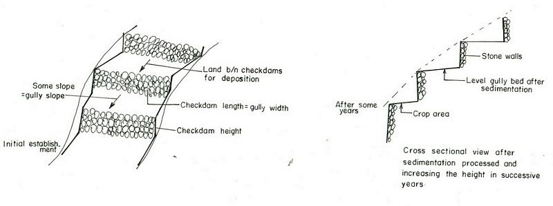
Техник тодорхойлолт (техник зургийн тайлбар):
Amhara
Technical knowledge required for field staff / advisors: high
Technical knowledge required for land users: moderate
Main technical functions: increase / maintain water stored in soil, sediment retention / trapping, sediment harvesting
Secondary technical functions: reduction of slope angle, reduction of slope length, increase of infiltration
Mixed cropping / intercropping
Material/ species: sorghum/maize +haricot beans
Quantity/ density: 70,000 sor
Remarks: broadcast
Agronomic measure: mixed cropping / intercropping
Material/ species: teff + sunflower
Quantity/ density: -
Remarks: broadcast
Manure / compost / residues
Material/ species: Animal dung, fuelwood ash, leaves, soil
Quantity/ density: 0.6 ton/ha
Contour tillage
Remarks: along contour
Agronomic measure: Sediment trapped by checkdam
Remarks: along the contour
Agronomic measure: Seedbed preparation by hoe
Aligned: -contour
Vegetative material: T : trees / shrubs
Number of plants per (ha): 1500
Vertical interval between rows / strips / blocks (m): 1-1.8m
Spacing between rows / strips / blocks (m): 8-10m
Vertical interval within rows / strips / blocks (m): 1-2m
Width within rows / strips / blocks (m): 1x1
Vegetative measure: aligned: contour
Vegetative material: G : grass
Number of plants per (ha): -
Vertical interval between rows / strips / blocks (m): 1-1.8m
Spacing between rows / strips / blocks (m): 8-10m
Vertical interval within rows / strips / blocks (m): -
Width within rows / strips / blocks (m): -
Vegetative measure: aligned: contour
Vegetative material: G : grass
Number of plants per (ha): 2000
Vertical interval between rows / strips / blocks (m): 1-1.8m
Spacing between rows / strips / blocks (m): 8-10m
Vertical interval within rows / strips / blocks (m): -
Width within rows / strips / blocks (m): -
Vegetative measure: Vegetative material: G : grass
Vegetative measure: Vegetative material: G : grass
Trees/ shrubs species: acacia, eucalyptus, khata edulis, ageava sisal
Fruit trees / shrubs species: coffee, papaya, guava, banana, lemon, manago, orange
Grass species: elephant grass, local grass
Slope (which determines the spacing indicated above): 12.00%
If the original slope has changed as a result of the Technology, the slope today is (see figure below): 3.00%
Gradient along the rows / strips: 0.00%
Structural measure: Checkdam
Vertical interval between structures (m): 1
Spacing between structures (m): 8m
Depth of ditches/pits/dams (m): 0.3m
Width of ditches/pits/dams (m): 1m
Length of ditches/pits/dams (m): 5m
Height of bunds/banks/others (m): 0.5-1m
Width of bunds/banks/others (m): 1m
Length of bunds/banks/others (m): 5.m
Construction material (earth): Soil is embnked upslope of the stone wall as reinforcement
Construction material (stone): Stone is used to construct the embankment/wall/and is supported by soil in the upslope side to reinf
Construction material (wood): Wood used as support at the downslope side
Slope (which determines the spacing indicated above): 12%
If the original slope has changed as a result of the Technology, the slope today is: 3%
Lateral gradient along the structure: 0%
For water harvesting: the ratio between the area where the harvested water is applied and the total area from which water is collected is: 1:3
Vegetation is used for stabilisation of structures.
Change of land use type: gully converted to cropland
Other type of management: fencing and guarding - protect animals from interering to plantations
4.2 Материал болон зардалд хамаарах ерөнхий мэдээлэл
бусад/үндэсний мөнгөн нэгж (тодорхойл):
Birr
Хэрэв боломжтой бол үндэсний валютын Америк доллартай харьцах харьцааг бичнэ үү (тухайлбал, 1 ам.дол. = 79,9 Бразил реал): 1 ам.дол. =:
8.6
Хөлсний ажилчны нэг өдрийн цалингийн хэмжээг тодорхойлно уу:
0.70
4.3 Бий болгох үйл ажиллагаа
| Үйл ажиллагаа | Хугацаа (улирал) | |
|---|---|---|
| 1. | Seedling production | March to June |
| 2. | Planting | June to July |
| 3. | Excavation | dry season |
| 4. | Stone collection | dry season |
| 5. | Construction | dry season |
| 6. | Fencing | after plantation |
4.4 Бий болгоход шаардагдсан зардал, хөрөнгийн өртөг
| Зардлын нэр, төрөл | Хэмжих нэгж | Тоо хэмжээ | Нэгжийн үнэ | Зардал бүрийн нийт өртөг | Нийт дүнгээс газар ашиглагчийн төлсөн % | |
|---|---|---|---|---|---|---|
| Хөдөлмөр эрхлэлт | Labour | ha | 1.0 | 4625.0 | 4625.0 | 90.0 |
| Тоног төхөөрөмж | Tools | ha | 1.0 | 120.0 | 120.0 | 95.0 |
| Барилгын материал | Stone | ha | 1.0 | 100.0 | ||
| Технологи бий болгох нийт үнэ өртөг | 4745.0 | |||||
| Технологи бий болгох нийт үнэ өртөг, ам.доллар | 551.74 | |||||
Тайлбар:
Duration of establishment phase: 180 month(s)
4.5 Арчилгаа/ урсгал үйл ажиллагаа
| Үйл ажиллагаа | Хугацаа/ давтамж | |
|---|---|---|
| 1. | clean crop residue | Early January / |
| 2. | primary digging | Feb-March / |
| 3. | harrowing | March / |
| 4. | manure application | March / |
| 5. | planting | April / |
| 6. | weeding and cultivation | Late June-August / |
| 7. | harvest | November-December / |
| 8. | replanting | during rains /once a year |
| 9. | pruning and thining | dry season /once a year |
| 10. | Stone collection | dry season/once a year |
| 11. | Placing the stones where maintenance is required | dry season/once a year |
| 12. | repairing breaks in fences | before replanting / annual |
4.6 Арчилгаа/урсгал ажилд шаардагдсан зардал, хөрөнгийн өртөг (нэг жилд)
| Зардлын нэр, төрөл | Хэмжих нэгж | Тоо хэмжээ | Нэгжийн үнэ | Зардал бүрийн нийт өртөг | Нийт дүнгээс газар ашиглагчийн төлсөн % | |
|---|---|---|---|---|---|---|
| Хөдөлмөр эрхлэлт | Labour | ha | 1.0 | 624.0 | 624.0 | 100.0 |
| Тоног төхөөрөмж | Tools | ha | 1.0 | 30.0 | 30.0 | 100.0 |
| Барилгын материал | Stone | ha | 1.0 | 100.0 | ||
| Технологийн арчилгаа/урсгал үйл ажиллагаанд шаардагдах нийт үнэ өртөг | 654.0 | |||||
| Технологи арчилах ба урсгал ажлын нийт үнэ өртөг, ам.доллар | 76.05 | |||||
Тайлбар:
Machinery/ tools: Shovel, hoe
Length per hectar of land
4.7 Зардалд нөлөөлж байгаа хамгийн чухал хүчин зүйл
Өртөг, зардалд нөлөөлөх гол хүчин зүйл:
labour, slope and depth of the gully, width of the gully, availability of construction material, soil depth. The establishment cost considerts the cost incurred over 15 years.
5. Байгаль ба нийгмийн нөхцөл
5.1 Уур амьсгал
Жилийн нийлбэр хур тундас
- < 250 мм
- 251-500 мм
- 501-750 мм
- 751-1,000 мм
- 1,001-1,500 мм
- 1,501-2,000 мм
- 2,001-3,000 мм
- 3,001-4,000 мм
- > 4,000 мм
Хур тунадасны талаархи тодорхойлолт/ тайлбар:
Specification 500-750 mm (600mm)
Specification 750-1000 mm (900mm)
Агро-уур амьсгалын бүс
- чийглэг
- хагас хуурай
Semi-arid: In the SWC area the semiarid part is about 70%
Sub-humid: Comprises about 30%
5.2 Гадаргын хэлбэр
Дундаж налуу:
- хавтгай (0-2 %)
- бага зэрэг налуу (3-5 %)
- дунд зэрэг налуу (6-10 % )
- хэвгий (11-15 %)
- налуу (16-30 %)
- их налуу (31-60 % )
- эгц налуу (>60 %)
Гадаргын хэлбэр:
- тэгш өндөрлөг / тал
- нуруу
- уулын энгэр
- дов толгод
- бэл
- хөндий
Өндрийн бүслүүр:
- 0-100 д.т.д. м.
- 101-500 д.т.д. м.
- 501-1,000 д.т.д м.
- 1,001-1,500 д.т.д м.
- 1,501-2,000 д.т.д м.
- 2,001-2,500 д.т.д. м.
- 2,501-3,000 д.т.д. м.
- 3,001-4,000 д.т.д м.
- > 4,000 д.т.д. м.
Гадаргын талаархи тодорхойлолт ба бусад тайлбар:
Landforms: Hill slopes (ranked 1, relatively drier and the technology is most suitable to this area) and ridges (ranked 2, the ridge separates the east and west parts the SWC area)
Slopes on average: Hilly (ranked 1, mostly terraced of stone bunds), rolling (ranked 2, more number of gullies and more area under the technology) and steep (ranked 3, bush lands suitable for grazing)
5.3 Хөрс
Хөрсний дундаж зузаан:
- маш нимгэн (0-20 см)
- нимгэн (21-50 см)
- дунд зэрэг зузаан (51-80 см)
- зузаан (81-120 cм)
- маш зузаан (>120 cм)
Хөрсний бүтэц (өнгөн хөрс):
- бүдүүн/ хөнгөн (элсэрхэг)
- дундаж (элсэнцэр, шавранцар)
Өнгөн хөрсөнд агуулагдах ялзмаг:
- бага (<1 % )
Боломжтой бол хөрсний бүрэн тодорхойлолт, боломжит мэдээллийг өгнө үү, жишээ нь хөрсний төрөл, хөрсний урвалын орчин/хүчиллэг байдал, катион солилцох чадавхи, азотын хэмжээ, давсжилт г.м.
Soil depth on average: Shallow (ranked1, more on hill slopes), moderately deep (ranked 2, on rolling terrain) and very shallow (ranked 3, on hilly and steep slopes)
Soil texture: Medium (dominant on hilly slopes) and coarse/light (on rolling terrains)
Soil fertility is low (on hilly sloping areas) and medium (on rolling lands)
Topsoil organic matter: Low (in all land forms)
Soil drainage/infiltration is good (on hilly and rolling lands) and medium (ridge)
Soil water storage capacity is low (on hilly and rolling lands) and medium (ridge)
5.6 Технологи нэвтрүүлсэн газар ашиглагчдын тухай мэдээлэл
Үйлдвэрлэлийн системийн зах зээлийн чиг баримжаа:
- амь зуух арга хэлбэрийн (өөрийгөө хангах)
- холимог (амьжиргаа ба худалдаанд)
Бусад эх үүсвэрээс олох орлого:
- Нийт орлогын 10 %-иас доош
Чинээлэг байдлын түвшин:
- ядуу
- дундаж
Механикжилтын түвшин:
- гар ажил
- ердийн хөсөг
Газар ашиглагчдын бусад шинж чанарыг тодорхойл:
Population density: 50-100 persons/km2
Annual population growth: 2% - 3%
20% of the land users are rich and own 30% of the land.
35% of the land users are average wealthy and own 30% of the land.
45% of the land users are poor and own 40% of the land.
Market orientation of garzing land production system: Subsistence (self-supply, production ids for self consumption and even it does not satistfy household needs)
Market orientation of crop land production system: Subsistence (self-supply) and mixed (subsistence and commercial)
Market orientation of crop land production system: Subsistence (self-supply, fuel wood collection for home consumption , construction wood, sell fuel woo and , make charcoal )
5.7 Газар ашиглагчийн технологи нэвтрүүлсэн газрын дундаж талбайн хэмжээ
- < 0.5 га
- 0.5-1 га
- 1-2 га
- 2-5 га
- 5-15 га
- 15-50 га
- 50-100 га
- 100-500 га
- 500-1,000 га
- 1,000-10,000 га
- > 10,000 га
5.8 Газар эзэмшил, газар ашиглах эрх, ус ашиглах эрх
Газар өмчлөл:
- төрийн
Газар ашиглах эрх:
- хувь хүн
6. Үр нөлөө ба дүгнэлт
6.1 Технологийн талбайд үзүүлсэн нөлөө
Нийгэм-эдийн засгийн үр нөлөө
Үйлдвэрлэл
газар тариалангийн үйлдвэрлэл
Тайлбар/ тодорхой дурьдах:
The cost benefit anlysis for sorghum shows negative profit but for other crops such as combination of coffe, papaya, chat the profit is high
тэжээл үйлдвэрлэл
тэжээлийн чанар
Орлого, зарлага
тухайн аж ахуйн орлого
Тайлбар/ тодорхой дурьдах:
for cropping patterns which consider field crops + cash crops is high
Нийгэм-соёлын үр нөлөө
ГТМ/ газрын доройтлын мэдлэг
Экологийн үр нөлөө
Усны эргэлт/ илүүдэл
гадаргын урсац
ГТМ хэрэгжихээс өмнөх тоо хэмжээ:
70
ГТМ хэрэгжиснээс хойшхи тоо хэмжээ:
5
Хөрс
хөрсний чийг
Тайлбар/ тодорхой дурьдах:
soil depth increased by depostion infiltration enhanced
хөрсөн бүрхэвч
Тайлбар/ тодорхой дурьдах:
plantations
хөрс алдагдах
ГТМ хэрэгжихээс өмнөх тоо хэмжээ:
10
ГТМ хэрэгжиснээс хойшхи тоо хэмжээ:
0
Тайлбар/ тодорхой дурьдах:
checdams decrease gully slope
Экологийн бусад үр нөлөө
Soil fertility
Тайлбар/ тодорхой дурьдах:
Fertile top soil erdoed upslope is trapped in the gully
Biodiversity
Тайлбар/ тодорхой дурьдах:
combined application of useful plants and crop
6.2 Технологийн талбайн гадна үзүүлсэн үр нөлөө
хуурай улиралд ашиглах найдвартай, тогтвортой урсац
Тайлбар/ тодорхой дурьдах:
high percolation rate of rain water
голын адагт үерлэх
Тайлбар/ тодорхой дурьдах:
runoff is trapped by supportive technologies undertaken in the upper catchment and runoof velocity retarded by checkdams
голын адагт лаг шавар хуримтлагдах
Тайлбар/ тодорхой дурьдах:
sediment trapped in the gullies
6.4 Өртөг ба ашгийн шинжилгээ
Бий болгох зардалтай харьцуулахад ямар ашиг өгсөн бэ (газар ашиглагчийн бодлоор)?
Богино хугацаанд эргэн төлөгдөх байдал:
сөрөг
Урт хугацаанд эргэн төлөгдөх байдал:
эерэг
Арчилгаа/урсгал зардалтай харьцуулахад ямар ашиг өгсөн бэ (газар ашиглагчийн бодлоор)?
Богино хугацаанд эргэн төлөгдөх байдал:
бага зэрэг сөрөг
Урт хугацаанд эргэн төлөгдөх байдал:
эерэг
6.5 Технологи нэвтрүүлэлт
Боломжтой бол, тоогоор илэрхийл (өрхийн тоо эсвэл бүрхэх талбай):
25000
Технологи нэвтрүүлсэн хүмүүсээс хэд нь өөрийн хүчээр технологийг хэрэгжүүлсэн бэ, өөрөөр хэлбэл гадны тусламж дэмжлэг авалгүйгээр?
- 91-100%
Тайлбар:
25000 land user families have adopted the Technology with external material support
Comments on acceptance with external material support: estimates
100% of land user families have adopted the Technology without any external material support
25000 land user families have adopted the Technology without any external material support
Comments on spontaneous adoption: estimates
There is a little trend towards spontaneous adoption of the Technology
Comments on adoption trend: Reclaiming gullies for agricultural land (crop and livestock production) is labourous.
6.7 Технологийн давуу тал/боломжууд
| Газар ашиглагчдын тодорхойлсон давуу тал/боломжууд |
|---|
|
Land reclaimed How can they be sustained / enhanced? fertility of soils increased by accumulated top soil from other area. |
|
retain moisture How can they be sustained / enhanced? water stored in the soil. |
| Эмхэтгэгч, бусад мэдээлэл өгсөн хүмүүсийн өнцгөөс тодорхойлсон давуу тал/боломжууд |
|---|
|
Reduce runoff speed How can they be sustained / enhanced? exercise frequent maintenance and stablize the structure with vegetative measures |
|
Reduce soil loss How can they be sustained / enhanced? soil is trapped by the checkdam |
|
Moisture retention How can they be sustained / enhanced? the soil trapped provides more space for water to be stored. |
|
reduce slope length How can they be sustained / enhanced? by raising the gully bed. |
7. Ном зүй ба холбоосууд
7.1 Мэдээлэл цуглуулсан арга/эх үүсвэр
7.2 Ном, хэвлэлийн ишлэл
Гарчиг, зохиогч, он, ISBN:
Monthly, quarterly and annual achievement reports of the DWARDO
Гарчиг, зохиогч, он, ISBN:
Work norm of MERET
Гарчиг, зохиогч, он, ISBN:
Ethiopian Highlands Reclamation stdy
Гарчиг, зохиогч, он, ISBN:
Soil and water conservation , Morgan 1986
Холбоос ба модулууд
Бүгдийг дэлгэх Бүгдийг хаахХолбоосууд
Холбоос байхгүй байна
Модулууд
Модуль байхгүй байна