Dawa-Cheffa Traditional Checkdam [埃塞俄比亚]
- 创建:
- 更新:
- 编制者: Unknown User
- 编辑者: –
- 审查者: Fabian Ottiger, Alexandra Gavilano
Kiter
technologies_1058 - 埃塞俄比亚
查看章节
全部展开 全部收起1. 一般信息
1.2 参与该技术评估和文件编制的资源人员和机构的联系方式
关键资源人
SLM专业人员:
Umer Kemal
Dewa Chefe Woreda Agriculture and Rural Development Office (DWARAO)
埃塞俄比亚
有助于对技术进行记录/评估的机构名称(如相关)
Ministry of Agriculture and Rural Development (Ministry of Agriculture and Rural Development) - 埃塞俄比亚1.3 关于使用通过WOCAT记录的数据的条件
编制者和关键资源人员接受有关使用通过WOCAT记录数据的条件。:
是
2. SLM技术的说明
2.1 技术简介
技术定义:
A structural measure constructed by stone/soil/wood acrross the gully to control erosion and create favourble condition for crop cultivation.
2.2 技术的详细说明
说明:
The technology is known by the farmers for more than a century. Since the area is highly affected by gully erosion, this practice is widely used by farmers in the area and also widely practiced. Its construction starts from the bottom of the gully and proceeds upslope with different dimensions. The height depends on the depth of the gully and it is increased from year to year. On the average the width is 1m and hieght is 1.80m. The technology is used to develop big gullies and treatment of small gully like depressions, attain slope change to enhance land suitability to crop production and to conserve soil and water. The construction of the stone checkdam starts with small heights and some height is added every year until the intended height is reached. The increase in height could be done during maintenance also. The major objective being to stop gully growth, trap sediment and retain water running down the gully. In the course of increasing the height, the area for sediment deposition gets wider. The technology is suitable to areas with low rainfalls of rugged topography having a network of gullies.
2.5 已应用该技术的、本评估所涵盖的国家/地区/地点
国家:
埃塞俄比亚
区域/州/省:
Amhara Regional State
有关地点的进一步说明:
Koshem Watershed
具体说明该技术的分布:
- 均匀地分布在一个区域
如果不知道精确的区域,请注明大致覆盖的区域:
- 10-100 平方千米
注释:
Total area covered by the SLM Technology is 810 km2.
The technology is mostly practiced in the eastern escarpment of the the woreda experiencing low and erratic rains. Area is estimated
Map
×2.6 实施日期
如果不知道确切的年份,请说明大概的日期:
- 50多年前(传统)
2.7 技术介绍
详细说明该技术是如何引入的:
- 作为传统系统的一部分(> 50 年)
注释(项目类型等):
Is developed by land users themselves
3. SLM技术的分类
3.1 该技术的主要目的
- 改良生产
- 减少、预防、恢复土地退化
3.2 应用该技术的当前土地利用类型

农田
- 一年一作
- 多年一作(非木材)
- 乔木与灌木的种植
年作 - 具体指明作物:
- 谷物类 - 玉米
- 谷类 - 高粱
- 豆科牧草和豆类 - 豆子
- 豆科牧草和豆类 - 其他
- 油料作物 - 向日葵、菜籽、其他
- haricot bean, teff
- sugar cane, elephant grass, local grass
乔木和灌木种植 - 指定作物:
- 柑橘属
- 咖啡,露天种植
- 水果、其他
- 芒果、山竹果、番石榴
- 木瓜
- acacia, eucalyptus, khata edulis, ageava sisal, banana, lemon
每年的生长季节数:
- 2
具体说明:
Longest growing period in days: 210 Longest growing period from month to month: May - Nov Second longest growing period in days: 180 Second longest growing period from month to month: Jan - Apr
采用间作制度了吗?:
是
如果是,说明哪些作物是间作的:
sorghum/maize +haricot beans

牧场

森林/林地
- (半天然)天然森林/林地
(半天然)天然森林/林地:具体说明管理类型:
- 皆伐
产品和服务:
- 木材
- 薪材
- 放牧/啃牧
注释:
Major land use problems (compiler’s opinion): Increase in human and animal population, overggrazing and expansion of cultivated lands to areas which are not suitable to cultivation is a problem. Meanwhile, owing to gully expansion and in the absence of preventive and control measures, there is considerable loss of soil from grazing and cultivated lands.
Major land use problems (land users’ perception): More area is getting out of production.
Other grazingland: extensive: pastoralism: in the eastern side of the SWC technology area
Other grazingland: extensive: semi-pastoralism: on the ridgea nd hilly slopes where land users are engaged in crop and livestock production
Grazingland comments: Livestock production is decreasing primarily because of decreasing grazing lands. The number of livestock being the most important factor for herd owners than the quailty. More extension work will be needed to promot the awarness of livestock owners in a way they give emphases to quality of livestock production than numbers.
Clear felling of (semi-)natural forests: to open land for cultivation, chrcoal making
Problems / comments regarding forest use: The natural forest/wood lands are decreasing mainly to expansion of cultivation and also due to high demand for use. However, because of plantations on gullies, hillside closures and woodlots there is a positive trend of increase of planted trees.
Type of cropping system and major crops comments: Fruit trees, sugar cane, pulses
Type of grazing system comments: Livestock production is decreasing primarily because of decreasing grazing lands. The number of livestock being the most important factor for herd owners than the quailty. More extension work will be needed to promot the awarness of livestock owners in a way they give emphases to quality of livestock production than numbers.
3.4 供水
该技术所应用土地的供水:
- 雨养
注释:
Water supply: Also mixed rainfed - irrigated
Water supply: post-flooding
3.5 该技术所属的SLM组
- 地表水管理(泉、河、湖、海)
3.6 包含该技术的可持续土地管理措施

农艺措施
- A1:植被和土壤覆盖层
- A2:有机质/土壤肥力
- A3:土壤表面处理
- A6:残株管理
- A7:其它

植物措施

结构措施
- S6:墙、障碍物、栅栏、围墙
注释:
Main measures: structural measures
Secondary measures: agronomic measures, vegetative measures
Type of agronomic measures: mixed cropping / intercropping, contour planting / strip cropping, legume inter-planting, manure / compost / residues, contour tillage
Type of vegetative measures: aligned: -contour
3.7 该技术强调的主要土地退化类型

土壤水蚀
- Wt:表土流失/地表侵蚀
- Wg:冲沟侵蚀/沟蚀

化学性土壤退化
- Cn:肥力下降和有机质含量下降(非侵蚀所致)
注释:
Main type of degradation addressed: Wg: gully erosion / gullying
Secondary types of degradation addressed: Wt: loss of topsoil / surface erosion, Cn: fertility decline and reduced organic matter content
Main causes of degradation: deforestation / removal of natural vegetation (incl. forest fires), overgrazing, other human induced causes (specify) (agricultural causes), labour availability (lack of labour), land subdivision
Secondary causes of degradation: over-exploitation of vegetation for domestic use, other natural causes (avalanches, volcanic eruptions, mud flows, highly susceptible natural resources, extreme topography, etc.) specify, poverty / wealth (lack of captial), education, access to knowledge and support services (lack of knowledge), lack of enforcement of legislat./authority
3.8 防止、减少或恢复土地退化
具体数量名该技术与土地退化有关的目标:
- 修复/恢复严重退化的土地
注释:
Secondary goals: prevention of land degradation, mitigation / reduction of land degradation
4. 技术规范、实施活动、投入和成本
4.1 该技术的技术图纸
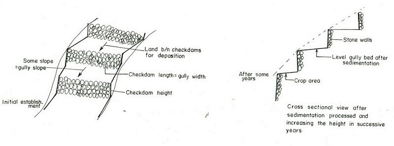
技术规范(与技术图纸相关):
Amhara
Technical knowledge required for field staff / advisors: high
Technical knowledge required for land users: moderate
Main technical functions: increase / maintain water stored in soil, sediment retention / trapping, sediment harvesting
Secondary technical functions: reduction of slope angle, reduction of slope length, increase of infiltration
Mixed cropping / intercropping
Material/ species: sorghum/maize +haricot beans
Quantity/ density: 70,000 sor
Remarks: broadcast
Agronomic measure: mixed cropping / intercropping
Material/ species: teff + sunflower
Quantity/ density: -
Remarks: broadcast
Manure / compost / residues
Material/ species: Animal dung, fuelwood ash, leaves, soil
Quantity/ density: 0.6 ton/ha
Contour tillage
Remarks: along contour
Agronomic measure: Sediment trapped by checkdam
Remarks: along the contour
Agronomic measure: Seedbed preparation by hoe
Aligned: -contour
Vegetative material: T : trees / shrubs
Number of plants per (ha): 1500
Vertical interval between rows / strips / blocks (m): 1-1.8m
Spacing between rows / strips / blocks (m): 8-10m
Vertical interval within rows / strips / blocks (m): 1-2m
Width within rows / strips / blocks (m): 1x1
Vegetative measure: aligned: contour
Vegetative material: G : grass
Number of plants per (ha): -
Vertical interval between rows / strips / blocks (m): 1-1.8m
Spacing between rows / strips / blocks (m): 8-10m
Vertical interval within rows / strips / blocks (m): -
Width within rows / strips / blocks (m): -
Vegetative measure: aligned: contour
Vegetative material: G : grass
Number of plants per (ha): 2000
Vertical interval between rows / strips / blocks (m): 1-1.8m
Spacing between rows / strips / blocks (m): 8-10m
Vertical interval within rows / strips / blocks (m): -
Width within rows / strips / blocks (m): -
Vegetative measure: Vegetative material: G : grass
Vegetative measure: Vegetative material: G : grass
Trees/ shrubs species: acacia, eucalyptus, khata edulis, ageava sisal
Fruit trees / shrubs species: coffee, papaya, guava, banana, lemon, manago, orange
Grass species: elephant grass, local grass
Slope (which determines the spacing indicated above): 12.00%
If the original slope has changed as a result of the Technology, the slope today is (see figure below): 3.00%
Gradient along the rows / strips: 0.00%
Structural measure: Checkdam
Vertical interval between structures (m): 1
Spacing between structures (m): 8m
Depth of ditches/pits/dams (m): 0.3m
Width of ditches/pits/dams (m): 1m
Length of ditches/pits/dams (m): 5m
Height of bunds/banks/others (m): 0.5-1m
Width of bunds/banks/others (m): 1m
Length of bunds/banks/others (m): 5.m
Construction material (earth): Soil is embnked upslope of the stone wall as reinforcement
Construction material (stone): Stone is used to construct the embankment/wall/and is supported by soil in the upslope side to reinf
Construction material (wood): Wood used as support at the downslope side
Slope (which determines the spacing indicated above): 12%
If the original slope has changed as a result of the Technology, the slope today is: 3%
Lateral gradient along the structure: 0%
For water harvesting: the ratio between the area where the harvested water is applied and the total area from which water is collected is: 1:3
Vegetation is used for stabilisation of structures.
Change of land use type: gully converted to cropland
Other type of management: fencing and guarding - protect animals from interering to plantations
4.2 有关投入和成本计算的一般信息
其它/国家货币(具体说明):
Birr
如相关,注明美元与当地货币的汇率(例如1美元=79.9巴西雷亚尔):1美元=:
8.6
注明雇用劳工的每日平均工资成本:
0.70
4.3 技术建立活动
| 活动 | 时间(季度) | |
|---|---|---|
| 1. | Seedling production | March to June |
| 2. | Planting | June to July |
| 3. | Excavation | dry season |
| 4. | Stone collection | dry season |
| 5. | Construction | dry season |
| 6. | Fencing | after plantation |
4.4 技术建立所需要的费用和投入
| 对投入进行具体说明 | 单位 | 数量 | 单位成本 | 每项投入的总成本 | 土地使用者承担的成本% | |
|---|---|---|---|---|---|---|
| 劳动力 | Labour | ha | 1.0 | 4625.0 | 4625.0 | 90.0 |
| 设备 | Tools | ha | 1.0 | 120.0 | 120.0 | 95.0 |
| 施工材料 | Stone | ha | 1.0 | 100.0 | ||
| 技术建立所需总成本 | 4745.0 | |||||
| 技术建立总成本,美元 | 551.74 | |||||
注释:
Duration of establishment phase: 180 month(s)
4.5 维护/经常性活动
| 活动 | 时间/频率 | |
|---|---|---|
| 1. | clean crop residue | Early January / |
| 2. | primary digging | Feb-March / |
| 3. | harrowing | March / |
| 4. | manure application | March / |
| 5. | planting | April / |
| 6. | weeding and cultivation | Late June-August / |
| 7. | harvest | November-December / |
| 8. | replanting | during rains /once a year |
| 9. | pruning and thining | dry season /once a year |
| 10. | Stone collection | dry season/once a year |
| 11. | Placing the stones where maintenance is required | dry season/once a year |
| 12. | repairing breaks in fences | before replanting / annual |
4.6 维护/经常性活动所需要的费用和投入(每年)
| 对投入进行具体说明 | 单位 | 数量 | 单位成本 | 每项投入的总成本 | 土地使用者承担的成本% | |
|---|---|---|---|---|---|---|
| 劳动力 | Labour | ha | 1.0 | 624.0 | 624.0 | 100.0 |
| 设备 | Tools | ha | 1.0 | 30.0 | 30.0 | 100.0 |
| 施工材料 | Stone | ha | 1.0 | 100.0 | ||
| 技术维护所需总成本 | 654.0 | |||||
| 技术维护总成本,美元 | 76.05 | |||||
注释:
Machinery/ tools: Shovel, hoe
Length per hectar of land
4.7 影响成本的最重要因素
描述影响成本的最决定性因素:
labour, slope and depth of the gully, width of the gully, availability of construction material, soil depth. The establishment cost considerts the cost incurred over 15 years.
5. 自然和人文环境
5.1 气候
年降雨量
- < 250毫米
- 251-500毫米
- 501-750毫米
- 751-1,000毫米
- 1,001-1,500毫米
- 1,501-2,000毫米
- 2,001-3,000毫米
- 3,001-4,000毫米
- > 4,000毫米
有关降雨的规范/注释:
Specification 500-750 mm (600mm)
Specification 750-1000 mm (900mm)
农业气候带
- 半湿润
- 半干旱
Semi-arid: In the SWC area the semiarid part is about 70%
Sub-humid: Comprises about 30%
5.2 地形
平均坡度:
- 水平(0-2%)
- 缓降(3-5%)
- 平缓(6-10%)
- 滚坡(11-15%)
- 崎岖(16-30%)
- 陡峭(31-60%)
- 非常陡峭(>60%)
地形:
- 高原/平原
- 山脊
- 山坡
- 山地斜坡
- 麓坡
- 谷底
垂直分布带:
- 0-100 m a.s.l.
- 101-500 m a.s.l.
- 501-1,000 m a.s.l.
- 1,001-1,500 m a.s.l.
- 1,501-2,000 m a.s.l.
- 2,001-2,500 m a.s.l.
- 2,501-3,000 m a.s.l.
- 3,001-4,000 m a.s.l.
- > 4,000 m a.s.l.
关于地形的注释和进一步规范:
Landforms: Hill slopes (ranked 1, relatively drier and the technology is most suitable to this area) and ridges (ranked 2, the ridge separates the east and west parts the SWC area)
Slopes on average: Hilly (ranked 1, mostly terraced of stone bunds), rolling (ranked 2, more number of gullies and more area under the technology) and steep (ranked 3, bush lands suitable for grazing)
5.3 土壤
平均土层深度:
- 非常浅(0-20厘米)
- 浅(21-50厘米)
- 中等深度(51-80厘米)
- 深(81-120厘米)
- 非常深(> 120厘米)
土壤质地(表土):
- 粗粒/轻(砂质)
- 中粒(壤土、粉土)
表土有机质:
- 低(<1%)
如有可能,附上完整的土壤描述或具体说明可用的信息,例如土壤类型、土壤酸碱度、阳离子交换能力、氮、盐度等。:
Soil depth on average: Shallow (ranked1, more on hill slopes), moderately deep (ranked 2, on rolling terrain) and very shallow (ranked 3, on hilly and steep slopes)
Soil texture: Medium (dominant on hilly slopes) and coarse/light (on rolling terrains)
Soil fertility is low (on hilly sloping areas) and medium (on rolling lands)
Topsoil organic matter: Low (in all land forms)
Soil drainage/infiltration is good (on hilly and rolling lands) and medium (ridge)
Soil water storage capacity is low (on hilly and rolling lands) and medium (ridge)
5.6 应用该技术的土地使用者的特征
生产系统的市场定位:
- 生计(自给)
- 混合(生计/商业)
非农收入:
- 低于全部收入的10%
相对财富水平:
- 贫瘠
- 平均水平
机械化水平:
- 手工作业
- 畜力牵引
说明土地使用者的其他有关特征:
Population density: 50-100 persons/km2
Annual population growth: 2% - 3%
20% of the land users are rich and own 30% of the land.
35% of the land users are average wealthy and own 30% of the land.
45% of the land users are poor and own 40% of the land.
Market orientation of garzing land production system: Subsistence (self-supply, production ids for self consumption and even it does not satistfy household needs)
Market orientation of crop land production system: Subsistence (self-supply) and mixed (subsistence and commercial)
Market orientation of crop land production system: Subsistence (self-supply, fuel wood collection for home consumption , construction wood, sell fuel woo and , make charcoal )
5.7 应用该技术的土地使用者使用的平均土地面积
- < 0.5 公顷
- 0.5-1 公顷
- 1-2 公顷
- 2-5公顷
- 5-15公顷
- 15-50公顷
- 50-100公顷
- 100-500公顷
- 500-1,000公顷
- 1,000-10,000公顷
- > 10,000公顷
5.8 土地所有权、土地使用权和水使用权
土地所有权:
- 州
土地使用权:
- 个人
6. 影响和结论性说明
6.1 该技术的现场影响
社会经济效应
生产
作物生产
注释/具体说明:
The cost benefit anlysis for sorghum shows negative profit but for other crops such as combination of coffe, papaya, chat the profit is high
饲料生产
饲料质量
收入和成本
农业收入
注释/具体说明:
for cropping patterns which consider field crops + cash crops is high
社会文化影响
SLM/土地退化知识
生态影响
水循环/径流
地表径流
SLM之前的数量:
70
SLM之后的数量:
5
土壤
土壤水分
注释/具体说明:
soil depth increased by depostion infiltration enhanced
土壤覆盖层
注释/具体说明:
plantations
土壤流失
SLM之前的数量:
10
SLM之后的数量:
0
注释/具体说明:
checdams decrease gully slope
其它生态影响
Soil fertility
注释/具体说明:
Fertile top soil erdoed upslope is trapped in the gully
Biodiversity
注释/具体说明:
combined application of useful plants and crop
6.2 该技术的场外影响已经显现
旱季稳定可靠的水流
注释/具体说明:
high percolation rate of rain water
下游洪水
注释/具体说明:
runoff is trapped by supportive technologies undertaken in the upper catchment and runoof velocity retarded by checkdams
下游淤积
注释/具体说明:
sediment trapped in the gullies
6.4 成本效益分析
技术收益与技术建立成本相比如何(从土地使用者的角度看)?
短期回报:
消极
长期回报:
积极
技术收益与技术维护成本/经常性成本相比如何(从土地使用者的角度看)?
短期回报:
轻度消极
长期回报:
积极
6.5 技术采用
如若可行,进行量化(住户数量和/或覆盖面积):
25000
在所有采用这项技术的人当中,有多少人是自发的,即未获得任何物质奖励/付款?:
- 91-100%
注释:
25000 land user families have adopted the Technology with external material support
Comments on acceptance with external material support: estimates
100% of land user families have adopted the Technology without any external material support
25000 land user families have adopted the Technology without any external material support
Comments on spontaneous adoption: estimates
There is a little trend towards spontaneous adoption of the Technology
Comments on adoption trend: Reclaiming gullies for agricultural land (crop and livestock production) is labourous.
6.7 该技术的优点/长处/机会
| 土地使用者眼中的长处/优势/机会 |
|---|
|
Land reclaimed How can they be sustained / enhanced? fertility of soils increased by accumulated top soil from other area. |
|
retain moisture How can they be sustained / enhanced? water stored in the soil. |
| 编制者或其他关键资源人员认为的长处/优势/机会 |
|---|
|
Reduce runoff speed How can they be sustained / enhanced? exercise frequent maintenance and stablize the structure with vegetative measures |
|
Reduce soil loss How can they be sustained / enhanced? soil is trapped by the checkdam |
|
Moisture retention How can they be sustained / enhanced? the soil trapped provides more space for water to be stored. |
|
reduce slope length How can they be sustained / enhanced? by raising the gully bed. |
7. 参考和链接
7.1 信息的方法/来源
7.2 参考可用出版物
标题、作者、年份、ISBN:
Monthly, quarterly and annual achievement reports of the DWARDO
标题、作者、年份、ISBN:
Work norm of MERET
标题、作者、年份、ISBN:
Ethiopian Highlands Reclamation stdy
标题、作者、年份、ISBN:
Soil and water conservation , Morgan 1986
链接和模块
全部展开 全部收起链接
无链接
模块
无模块