Dawa-Cheffa Traditional Checkdam [ອີທິໂອເປຍ]
- ການສ້າງ:
- ປັບປູງ:
- ຜູ້ສັງລວມຂໍ້ມູນ: Unknown User
- ບັນນາທິການ: –
- ຜູ້ທົບທວນຄືນ: Fabian Ottiger, Alexandra Gavilano
Kiter
technologies_1058 - ອີທິໂອເປຍ
ເບິ່ງພາກສ່ວນ
ຂະຫຍາຍທັງໝົດ ຍຸບທັງໝົດ1. ຂໍ້ມູນທົ່ວໄປ
1.2 ຂໍ້ມູນ ການຕິດຕໍ່ພົວພັນ ຂອງບຸກຄົນທີ່ສໍາຄັນ ແລະ ສະຖາບັນ ທີ່ມີສ່ວນຮ່ວມ ໃນການປະເມີນເອກກະສານ ເຕັກໂນໂລຢີ
ບັນດາຜູ້ຕອບແບບສອບຖາມທີ່ສໍາຄັນ ()
ຜຸ້ຊ່ຽວຊານ ດ້ານການຄຸ້ມຄອງ ທີ່ດິນແບບຍືນຍົງ:
Umer Kemal
Dewa Chefe Woreda Agriculture and Rural Development Office (DWARAO)
ອີທິໂອເປຍ
ຊື່ສະຖາບັນ (ຫຼາຍສະຖາບັນ) ທີ່ອໍານວຍຄວາມສະດວກ ໃນການສ້າງເອກກະສານ / ປະເມີນ ເຕັກໂນໂລຢີ (ຖ້າກ່ຽວຂ້ອງ)
Ministry of Agriculture and Rural Development (Ministry of Agriculture and Rural Development) - ອີທິໂອເປຍ1.3 ເງື່ອນໄຂ ກ່ຽວກັບ ການນໍາໃຊ້ຂໍ້ມູນເອກະສານ ທີ່ສ້າງຂື້ນ ໂດຍຜ່ານ ອົງການພາບລວມຂອງໂລກ ທາງດ້ານແນວທາງ ແລະ ເຕັກໂນໂລຢີ ຂອງການອານຸລັກ ທໍາມະຊາດ (WOCAT)
ຜູ້ປ້ອນຂໍ້ມູນ ແລະ ບຸກຄົນສຳຄັນ ທີ່ໃຫ້ຂໍ້ມູນ (ຫຼາຍ) ຍິນຍອມ ຕາມເງື່ອນໄຂ ໃນການນຳໃຊ້ຂໍ້ມູນ ເພື່ອສ້າງເປັນເອກກະສານຂອງ WOCAT:
ແມ່ນ
2. ການອະທິບາຍ ເຕັກໂນໂລຢີ ຂອງການຄຸ້ມຄອງ ທີ່ດິນແບບຍືນຍົງ
2.1 ຄໍາອະທິບາຍສັ້ນຂອງ ເຕັກໂນໂລຢີ
ການກຳໜົດຄວາມໝາຍ ຂອງເຕັກໂນໂລຢີ:
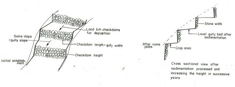
A structural measure constructed by stone/soil/wood acrross the gully to control erosion and create favourble condition for crop cultivation.
2.2 ການອະທິບາຍ ລາຍລະອຽດ ຂອງເຕັກໂນໂລຢີ
ການພັນລະນາ:
The technology is known by the farmers for more than a century. Since the area is highly affected by gully erosion, this practice is widely used by farmers in the area and also widely practiced. Its construction starts from the bottom of the gully and proceeds upslope with different dimensions. The height depends on the depth of the gully and it is increased from year to year. On the average the width is 1m and hieght is 1.80m. The technology is used to develop big gullies and treatment of small gully like depressions, attain slope change to enhance land suitability to crop production and to conserve soil and water. The construction of the stone checkdam starts with small heights and some height is added every year until the intended height is reached. The increase in height could be done during maintenance also. The major objective being to stop gully growth, trap sediment and retain water running down the gully. In the course of increasing the height, the area for sediment deposition gets wider. The technology is suitable to areas with low rainfalls of rugged topography having a network of gullies.
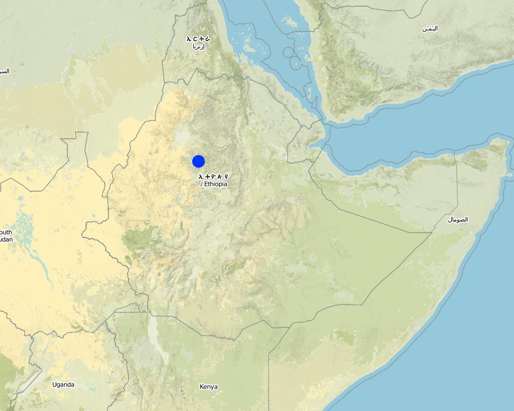
2.5 ປະເທດ / ເຂດ / ສະຖານທີ່ບ່ອນທີ່ ເຕັກໂນໂລຢີ ໄດ້ຮັບການນໍາໃຊ້ ແລະ ທີ່ຖືກປົກຄຸມດ້ວຍການປະເມີນຜົນ
ປະເທດ:
ອີທິໂອເປຍ
ພາກພື້ນ / ລັດ / ແຂວງ:
Amhara Regional State
ຂໍ້ມູນເພີ່ມເຕີມຂອງສະຖານທີ່:
Koshem Watershed
ໃຫ້ລະບຸ ການແຜ່ຂະຫຍາຍ ເຕັກໂນໂລຢີ:
- ແຜ່ຂະຫຍາຍຢ່າງໄວວາໃນພື້ນທີ່
ຖ້າຫາກບໍ່ຮູ້ເນື້ອທີ່ທີ່ແນ່ນອນ, ໃຫ້ລະບຸ ເນື້ອທີ່ໂດຍປະມານ ທີ່ໃກ້ຄຽງ:
- 10-100 ກມ 2
ຄວາມຄິດເຫັນ:
Total area covered by the SLM Technology is 810 km2.
The technology is mostly practiced in the eastern escarpment of the the woreda experiencing low and erratic rains. Area is estimated
Map
×2.6 ວັນທີໃນການຈັດຕັ້ງປະຕິບັດ
ຖ້າຫາກວ່າ ບໍ່ຮູ້ຈັກ ປີທີ່ຊັດເຈນ ແມ່ນໃຫ້ປະມານ ວັນທີເອົາ:
- ຫຼາຍກ່ອນ 50 ປີຜ່ານມາ (ແບບພື້ນບ້ານ)
2.7 ການນໍາສະເໜີ ເຕັກໂນໂລຢີ
ໃຫ້ລະບຸ ເຕັກໂນໂລຢີ ໄດ້ຖືກຈັດຕັ້ງປະຕິບັດຄືແນວໃດ?
- ເປັນສ່ວນໜື່ງຂອງລະບົບພື້ນເມືອງ (>50 ປີ)
ຄວາມຄິດເຫັນ (ປະເພດ ໂຄງການ ແລະ ອື່ນໆ):
Is developed by land users themselves
3. ການໃຈ້ແຍກ ເຕັກໂນໂລຢີ ໃນການຄຸ້ມຄອງ ດິນແບບຍືນຍົງ
3.1 ຈຸດປະສົງຫຼັກ (ຫຼາຍ) ຂອງເຕັກໂນໂລຢີ
- ປັບປຸງ ການຜະລິດ
- ຫຼຸດຜ່ອນ, ປ້ອງກັນ, ຟື້ນຟູ ການເຊື່ອມໂຊມຂອງດິນ
3.2 ປະເພດການນໍາໃຊ້ທີ່ດິນ ໃນປະຈຸບັນ() ທີ່ເຕັກໂນໂລຢີ ໄດ້ຖືກນໍາໃຊ້

ດິນທີ່ປູກພືດ
- ການປູກພືດປະຈໍາປີ
- ພືດຢືນຕົ້ນ (ບໍ່ແມ່ນໄມ້)
- ເປັນໄມ້ຢືນຕົ້ນ ແລະ ໄມ້ພຸ່ມ ຈາກການປູກພືດ
ການປູກພືດປະຈຳປີ - ລະບຸປະເພດພືດ:
- ທັນຍາພືດ-ສາລີ
- ທັນຍາພືດ-ເຂົ້າຟາງ
- ພືດຕະກູນຖົ່ວ ແລະ ຖົ່ວປະເພດອື່ນໆ
- ພືດຕະກູນຖົ່ວ ແລະ ຖົ່ວປະເພດອື່ນໆ
- ພືດປະເພດເມັດໃຫ້ນ້ຳມັນ-ດອກຕາເວັນ, ແກ່ນຜັກກາດ, ອື່ນໆ
- haricot bean, teff
- sugar cane, elephant grass, local grass
ການປູກພືດທີ່ເປັນຕົ້ນໄມ້ ແລະ ໄມ້ພຸ່ມ - ລະບຸປະເພດພືດ:
- ໝາກນາວ
- ກາເຟ, ປູກຢູ່ພື້ນທີ່ເປີດ
- ໝາກໄມ້, ອື່ນໆ
- ໝາກມ່ວງ, ໝາກມັງຄຸດ, ໝາກສີດາ
- ໝາກຮຸ່ງ
- acacia, eucalyptus, khata edulis, ageava sisal, banana, lemon
ຈໍານວນ ລະດູການ ປູກໃນປີໜຶ່ງ:
- 2
ລະບຸ ຊະນິດ:
Longest growing period in days: 210 Longest growing period from month to month: May - Nov Second longest growing period in days: 180 Second longest growing period from month to month: Jan - Apr
ມີການເຝືກປູກພືດແບບສັບຫວ່າງບໍ່?
ແມ່ນ
ຖ້າມີ, ໃຫ້ລະບຸວ່າປູກພືດຊະນິດໃດທີ່ປູກສັບຫວ່າງ:
sorghum/maize +haricot beans

ທົ່ງຫຍ້າລ້ຽງສັດ

ປ່າໄມ້ / ປ່າ
- (ເຄິ່ງ) ປ່າໄມ້ທໍາມະຊາດ / ປ່າປູກໄມ້
(ເຄີ່ງ) ປ່າທໍາມະຊາດ / ປ່າປູກ: ລະບຸປະເພດການຄຸ້ມຄອງ:
- ການຕັດກ້ຽງໝົດທຸກຕົ້ນ
ຜົນຜະລິດ ແລະ ການບໍລິການ:
- ເຄື່ອງປ່າຂອງດົງ
- ໄມ້ຟືນ
- ທົ່ງຫຍ້າ
ຄວາມຄິດເຫັນ:
Major land use problems (compiler’s opinion): Increase in human and animal population, overggrazing and expansion of cultivated lands to areas which are not suitable to cultivation is a problem. Meanwhile, owing to gully expansion and in the absence of preventive and control measures, there is considerable loss of soil from grazing and cultivated lands.
Major land use problems (land users’ perception): More area is getting out of production.
Other grazingland: extensive: pastoralism: in the eastern side of the SWC technology area
Other grazingland: extensive: semi-pastoralism: on the ridgea nd hilly slopes where land users are engaged in crop and livestock production
Grazingland comments: Livestock production is decreasing primarily because of decreasing grazing lands. The number of livestock being the most important factor for herd owners than the quailty. More extension work will be needed to promot the awarness of livestock owners in a way they give emphases to quality of livestock production than numbers.
Clear felling of (semi-)natural forests: to open land for cultivation, chrcoal making
Problems / comments regarding forest use: The natural forest/wood lands are decreasing mainly to expansion of cultivation and also due to high demand for use. However, because of plantations on gullies, hillside closures and woodlots there is a positive trend of increase of planted trees.
Type of cropping system and major crops comments: Fruit trees, sugar cane, pulses
Type of grazing system comments: Livestock production is decreasing primarily because of decreasing grazing lands. The number of livestock being the most important factor for herd owners than the quailty. More extension work will be needed to promot the awarness of livestock owners in a way they give emphases to quality of livestock production than numbers.
3.4 ການສະໜອງນ້ຳ
ການສະໜອງນໍ້າ ໃນພື້ນທີ່ ທີ່ໄດ້ນໍາໃຊ້ ເຕັກໂນໂລຢີ:
- ນໍ້າຝົນ
ຄວາມຄິດເຫັນ:
Water supply: Also mixed rainfed - irrigated
Water supply: post-flooding
3.5 ການນໍາໃຊ້ເຕັກໂນໂລຢີ ທີ່ຢູ່ໃນກຸ່ມການຄຸ້ມຄອງ ທີ່ດິນແບບຍືນຍົງ
- ການຄຸ້ມຄອງນໍ້າໜ້າດິນ (ນ້ຳຈາກພຸ, ແມ່ນໍ້າ, ທະເລສາບ, ທະເລ)
3.6 ມາດຕະການ ການຄຸ້ມຄອງ ທີ່ດິນແບບຍືນຍົງ ປະກອບດ້ວຍ ເຕັກໂນໂລຢີ

ມາດຕະການ ທາງການກະສິກໍາ
- A1: ພືດ / ການປົກຫຸ້ມຂອງດິນ
- A2: ອິນຊີວັດຖຸ ຫຼື ຄວາມອຸດົມສົມບູນໃນດິນ
- A3: ການບໍາລຸງຮັກສາຊັ້ນໜ້າດິນ
- A6: ການຈັດການສິ່ງເສດເຫຼືອ
- A7: ອື່ນໆ

ມາດຕະການ ທາງດ້ານພືດພັນ

ມາດຕະການໂຄງສ້າງ
- S6: ແລວກັນເຈື່ອນ, ຮົ້ວ
ຄວາມຄິດເຫັນ:
Main measures: structural measures
Secondary measures: agronomic measures, vegetative measures
Type of agronomic measures: mixed cropping / intercropping, contour planting / strip cropping, legume inter-planting, manure / compost / residues, contour tillage
Type of vegetative measures: aligned: -contour
3.7 ປະເພດດິນເຊື່ອມໂຊມ ຫຼັກທີ່ໄດ້ນໍາໃຊ້ ເຕັກໂນໂລຢີ

ດິນເຊາະເຈື່ອນ ໂດຍນໍ້າ
- Wt: ການສູນເສຍຊັ້ນໜ້າດິນ / ການເຊາະເຈື່ອນຜິວໜ້າດິນ
- Wg: ການເຊາະເຈື່ອນຮ່ອງນ້ຳ / ຫ້ວຍ

ການເຊື່ອມໂຊມ ຂອງດິນ ທາງເຄມີ
- Cn: ຄວາມອຸດົມສົມບູນ ລົດໜ້ອຍຖອຍລົງ ແລະ ສານອິນຊີວັດຖຸລົດລົງ (ບໍ່ແມ່ນສາເຫດມາຈາກການເຊາະເຈື່ອນ)
ຄວາມຄິດເຫັນ:
Main type of degradation addressed: Wg: gully erosion / gullying
Secondary types of degradation addressed: Wt: loss of topsoil / surface erosion, Cn: fertility decline and reduced organic matter content
Main causes of degradation: deforestation / removal of natural vegetation (incl. forest fires), overgrazing, other human induced causes (specify) (agricultural causes), labour availability (lack of labour), land subdivision
Secondary causes of degradation: over-exploitation of vegetation for domestic use, other natural causes (avalanches, volcanic eruptions, mud flows, highly susceptible natural resources, extreme topography, etc.) specify, poverty / wealth (lack of captial), education, access to knowledge and support services (lack of knowledge), lack of enforcement of legislat./authority
3.8 ການປ້ອງກັນ, ການຫຼຸດຜ່ອນ, ຫຼືການຟື້ນຟູຂອງການເຊື່ອມໂຊມຂອງດິນ
ໃຫ້ລະບຸ ເປົ້າໝາຍ ເຕັກໂນໂລຢີ ທີ່ພົວພັນ ກັບຄວາມເຊື່ອມໂຊມຂອງດິນ:
- ການຟື້ນຟູ / ຟື້ນຟູດິນທີ່ຊຸດໂຊມ
ຄວາມຄິດເຫັນ:
Secondary goals: prevention of land degradation, mitigation / reduction of land degradation
4. ຂໍ້ກໍາໜົດ, ກິດຈະກໍາການປະຕິບັດ, ວັດຖຸດິບ, ແລະຄ່າໃຊ້ຈ່າຍ
4.1 ເຕັກນິກ ໃນການແຕ້ມແຜນວາດ ເຕັກໂນໂລຢີ
ຄຸນລັກສະນະ ຂອງເຕັກນິກ (ທີ່ກ່ຽວຂ້ອງ ກັບການແຕ້ມແຜນວາດ ທາງດ້ານເຕັກນີກ):
Amhara
Technical knowledge required for field staff / advisors: high
Technical knowledge required for land users: moderate
Main technical functions: increase / maintain water stored in soil, sediment retention / trapping, sediment harvesting
Secondary technical functions: reduction of slope angle, reduction of slope length, increase of infiltration
Mixed cropping / intercropping
Material/ species: sorghum/maize +haricot beans
Quantity/ density: 70,000 sor
Remarks: broadcast
Agronomic measure: mixed cropping / intercropping
Material/ species: teff + sunflower
Quantity/ density: -
Remarks: broadcast
Manure / compost / residues
Material/ species: Animal dung, fuelwood ash, leaves, soil
Quantity/ density: 0.6 ton/ha
Contour tillage
Remarks: along contour
Agronomic measure: Sediment trapped by checkdam
Remarks: along the contour
Agronomic measure: Seedbed preparation by hoe
Aligned: -contour
Vegetative material: T : trees / shrubs
Number of plants per (ha): 1500
Vertical interval between rows / strips / blocks (m): 1-1.8m
Spacing between rows / strips / blocks (m): 8-10m
Vertical interval within rows / strips / blocks (m): 1-2m
Width within rows / strips / blocks (m): 1x1
Vegetative measure: aligned: contour
Vegetative material: G : grass
Number of plants per (ha): -
Vertical interval between rows / strips / blocks (m): 1-1.8m
Spacing between rows / strips / blocks (m): 8-10m
Vertical interval within rows / strips / blocks (m): -
Width within rows / strips / blocks (m): -
Vegetative measure: aligned: contour
Vegetative material: G : grass
Number of plants per (ha): 2000
Vertical interval between rows / strips / blocks (m): 1-1.8m
Spacing between rows / strips / blocks (m): 8-10m
Vertical interval within rows / strips / blocks (m): -
Width within rows / strips / blocks (m): -
Vegetative measure: Vegetative material: G : grass
Vegetative measure: Vegetative material: G : grass
Trees/ shrubs species: acacia, eucalyptus, khata edulis, ageava sisal
Fruit trees / shrubs species: coffee, papaya, guava, banana, lemon, manago, orange
Grass species: elephant grass, local grass
Slope (which determines the spacing indicated above): 12.00%
If the original slope has changed as a result of the Technology, the slope today is (see figure below): 3.00%
Gradient along the rows / strips: 0.00%
Structural measure: Checkdam
Vertical interval between structures (m): 1
Spacing between structures (m): 8m
Depth of ditches/pits/dams (m): 0.3m
Width of ditches/pits/dams (m): 1m
Length of ditches/pits/dams (m): 5m
Height of bunds/banks/others (m): 0.5-1m
Width of bunds/banks/others (m): 1m
Length of bunds/banks/others (m): 5.m
Construction material (earth): Soil is embnked upslope of the stone wall as reinforcement
Construction material (stone): Stone is used to construct the embankment/wall/and is supported by soil in the upslope side to reinf
Construction material (wood): Wood used as support at the downslope side
Slope (which determines the spacing indicated above): 12%
If the original slope has changed as a result of the Technology, the slope today is: 3%
Lateral gradient along the structure: 0%
For water harvesting: the ratio between the area where the harvested water is applied and the total area from which water is collected is: 1:3
Vegetation is used for stabilisation of structures.
Change of land use type: gully converted to cropland
Other type of management: fencing and guarding - protect animals from interering to plantations
4.2 ຂໍ້ມູນທົ່ວໄປກ່ຽວກັບການຄິດໄລ່ປັດໃຈຂາເຂົ້າໃນການຜະລິດ ແລະ ມູນຄ່າອື່ນໆ
ສະກຸນເງິນອື່ນໆ / ປະເທດອື່ນໆ (ລະບຸ):
Birr
ຖ້າກ່ຽວຂ້ອງ, ໃຫ້ລະບຸອັດຕາແລກປ່ຽນຈາກ USD ເປັນສະກຸນເງິນທ້ອງຖິ່ນ (ເຊັ່ນ: 1 USD = 79.9 Brazilian Real): 1 USD =:
8.6
ລະບຸ ຄ່າຈ້າງ ຄ່າແຮງງານສະເລ່ຍ ຕໍ່ ວັນ:
0.70
4.3 ການສ້າງຕັ້ງກິດຈະກໍາ
| ກິດຈະກໍາ | Timing (season) | |
|---|---|---|
| 1. | Seedling production | March to June |
| 2. | Planting | June to July |
| 3. | Excavation | dry season |
| 4. | Stone collection | dry season |
| 5. | Construction | dry season |
| 6. | Fencing | after plantation |
4.4 ຕົ້ນທຶນ ແລະ ປັດໄຈຂາເຂົ້າທີ່ຈໍາເປັນໃນຈັດຕັ້ງປະຕິບັດ
| ລະບຸ ປັດໃຈ ນໍາເຂົ້າ ໃນການຜະລີດ | ຫົວໜ່ວຍ | ປະລິມານ | ຕົ້ນທຶນ ຕໍ່ຫົວໜ່ວຍ | ຕົ້ນທຶນທັງໝົດ ຂອງປັດໃຈຂາເຂົ້າ ໃນການຜະລິດ | % ຂອງຕົ້ນທຶນທັງໝົດ ທີ່ຜູ້ນໍາໃຊ້ທີ່ດິນ ໃຊ້ຈ່າຍເອງ | |
|---|---|---|---|---|---|---|
| ແຮງງານ | Labour | ha | 1.0 | 4625.0 | 4625.0 | 90.0 |
| ອຸປະກອນ | Tools | ha | 1.0 | 120.0 | 120.0 | 95.0 |
| ວັດສະດຸກໍ່ສ້າງ | Stone | ha | 1.0 | 100.0 | ||
| ຕົ້ນທຶນທັງໝົດ ໃນການຈັດຕັ້ງປະຕິບັດ ເຕັກໂນໂລຢີ | 4745.0 | |||||
| ຄ່າໃຊ້ຈ່າຍທັງໝົດ ສຳລັບການສ້າງຕັ້ງເຕັກໂນໂລຢີ ເປັນສະກຸນເງີນໂດລາ | 551.74 | |||||
ຄວາມຄິດເຫັນ:
Duration of establishment phase: 180 month(s)
4.5 ບໍາລຸງຮັກສາ / ແຜນຈັດຕັ້ງປະຕິບັດ ກິດຈະກໍາ
| ກິດຈະກໍາ | ໄລຍະເວລາ / ຄວາມຖີ່ | |
|---|---|---|
| 1. | clean crop residue | Early January / |
| 2. | primary digging | Feb-March / |
| 3. | harrowing | March / |
| 4. | manure application | March / |
| 5. | planting | April / |
| 6. | weeding and cultivation | Late June-August / |
| 7. | harvest | November-December / |
| 8. | replanting | during rains /once a year |
| 9. | pruning and thining | dry season /once a year |
| 10. | Stone collection | dry season/once a year |
| 11. | Placing the stones where maintenance is required | dry season/once a year |
| 12. | repairing breaks in fences | before replanting / annual |
4.6 ຄ່າໃຊ້ຈ່າຍ ແລະ ປັດໄຈນໍາເຂົ້າທີ່ຈໍາເປັນສໍາລັບການບໍາລຸງຮັກສາກິດຈະກໍາ / ແຜນປະຕິບັດ (ຕໍ່ປີ)
| ລະບຸ ປັດໃຈ ນໍາເຂົ້າ ໃນການຜະລີດ | ຫົວໜ່ວຍ | ປະລິມານ | ຕົ້ນທຶນ ຕໍ່ຫົວໜ່ວຍ | ຕົ້ນທຶນທັງໝົດ ຂອງປັດໃຈຂາເຂົ້າ ໃນການຜະລິດ | % ຂອງຕົ້ນທຶນທັງໝົດ ທີ່ຜູ້ນໍາໃຊ້ທີ່ດິນ ໃຊ້ຈ່າຍເອງ | |
|---|---|---|---|---|---|---|
| ແຮງງານ | Labour | ha | 1.0 | 624.0 | 624.0 | 100.0 |
| ອຸປະກອນ | Tools | ha | 1.0 | 30.0 | 30.0 | 100.0 |
| ວັດສະດຸກໍ່ສ້າງ | Stone | ha | 1.0 | 100.0 | ||
| ຕົ້ນທຶນທັງໝົດ ທີ່ໃຊ້ໃນການບໍາລຸງຮັກສາ ເຕັກໂນໂລຢີ | 654.0 | |||||
| ຄ່າໃຊ້ຈ່າຍທັງໝົດ ສຳລັບການບົວລະບັດຮກສາເຕັກໂນໂລຢີ ເປັນສະກຸນເງີນໂດລາ | 76.05 | |||||
ຄວາມຄິດເຫັນ:
Machinery/ tools: Shovel, hoe
Length per hectar of land
4.7 ປັດໄຈ ທີ່ສໍາຄັນ ທີ່ສົ່ງຜົນກະທົບ ຕໍ່ຄ່າໃຊ້ຈ່າຍ
ໃຫ້ອະທິບາຍ ປັດໃຈ ທີ່ສົ່ງຜົນກະທົບ ຕໍ່ຕົ້ນທຶນ ໃນການຈັດຕັ້ງປະຕິບັດ:
labour, slope and depth of the gully, width of the gully, availability of construction material, soil depth. The establishment cost considerts the cost incurred over 15 years.
5. ສະພາບແວດລ້ອມທໍາມະຊາດ ແລະ ມະນຸດ
5.1 ອາກາດ
ປະລິມານນໍ້າຝົນປະຈໍາປີ
- < 250 ມີລິແມັດ
- 251-500 ມີລິແມັດ
- 501-750 ມີລິແມັດ
- 751-1,000 ມີລິແມັດ
- 1,001-1,500 ມີລິແມັດ
- 1,501-2,000 ມີລິແມັດ
- 2,001-3,000 ມີລິແມັດ
- 3,001-4,000 ມີລິແມັດ
- > 4,000 ມີລິແມັດ
ຂໍ້ມູນສະເພາະ / ຄວາມເຫັນກ່ຽວກັບ ປະລິມານນໍ້າຝົນ:
Specification 500-750 mm (600mm)
Specification 750-1000 mm (900mm)
ເຂດສະພາບອາກາດກະສິກໍາ
- ເຄີ່ງຄວາມຊຸ່ມ
- ເຄິ່ງແຫ້ງແລ້ງ
Semi-arid: In the SWC area the semiarid part is about 70%
Sub-humid: Comprises about 30%
5.2 ພູມິປະເທດ
ຄ່າສະເລ່ຍ ຄວາມຄ້ອຍຊັນ:
- ພື້ນທີ່ຮາບພຽງ (0-2%)
- ອ່ອນ (3-5 %)
- ປານກາງ (6-10 %)
- ມ້ວນ (11-15 %)
- ເນີນ(16-30%)
- ໍຊັນ (31-60%)
- ຊັນຫຼາຍ (>60%)
ຮູບແບບຂອງດິນ:
- ພູພຽງ / ທົ່ງພຽງ
- ສັນພູ
- ເປີ້ນພູ
- ເນີນພູ
- ຕີນພູ
- ຮ່ອມພູ
ເຂດລະດັບສູງ:
- 0-100 ແມັດ a.s.l.
- 101-500 ແມັດ a.s.l.
- 501-1,000 ແມັດ a.s.l.
- 1,001-1,500 ແມັດ a.s.l.
- 1,501-2,000 ແມັດ a.s.l.
- 2,001-2,500 ແມັດ a.s.l.
- 2,501-3,000 ແມັດ a.s.l.
- 3,001-4,000 ແມັດ a.s.l.
- > 4,000 ແມັດ a.s.l.
ຄຳເຫັນ ແລະ ຂໍ້ມູນສະເພາະ ເພີ່ມເຕີມ ກ່ຽວກັບ ພູມີປະເທດ:
Landforms: Hill slopes (ranked 1, relatively drier and the technology is most suitable to this area) and ridges (ranked 2, the ridge separates the east and west parts the SWC area)
Slopes on average: Hilly (ranked 1, mostly terraced of stone bunds), rolling (ranked 2, more number of gullies and more area under the technology) and steep (ranked 3, bush lands suitable for grazing)
5.3 ດິນ
ຄວາມເລິກ ຂອງດິນສະເລ່ຍ:
- ຕື້ນຫຼາຍ (0-20 ຊັງຕີແມັດ)
- ຕື້ນ (21-50 ຊຕມ)
- ເລີກປານກາງ (51-80 ຊຕມ)
- ເລິກ (81-120 ຊມ)
- ເລິກຫຼາຍ (> 120 cm)
ເນື້ອດິນ (ໜ້າດິນ):
- ຫຍາບ / ເບົາ (ດິນຊາຍ)
- ປານກາງ (ດິນໜຽວ, ດິນໂຄນ)
ຊັ້ນອິນຊີວັດຖຸ ເທິງໜ້າດິນ:
- ຕໍາ່ (<1 %)
ຖ້າເປັນໄປໄດ້ ແມ່ນໃຫ້ຕິດຄັດ ການພັນລະນາດິນ ຫຼື ຂໍ້ມູນສະເພາະຂອງດິນ, ຕົວຢ່າງ, ຄຸນລັກສະນະ ປະເພດຂອງດິນ, ຄ່າຄວາມເປັນກົດ / ເປັນດ່າງຂອງດິນ, ສານອາຫານ, ດິນເຄັມ ແລະ ອື່ນໆ.
Soil depth on average: Shallow (ranked1, more on hill slopes), moderately deep (ranked 2, on rolling terrain) and very shallow (ranked 3, on hilly and steep slopes)
Soil texture: Medium (dominant on hilly slopes) and coarse/light (on rolling terrains)
Soil fertility is low (on hilly sloping areas) and medium (on rolling lands)
Topsoil organic matter: Low (in all land forms)
Soil drainage/infiltration is good (on hilly and rolling lands) and medium (ridge)
Soil water storage capacity is low (on hilly and rolling lands) and medium (ridge)
5.6 ຄຸນລັກສະນະ ຂອງຜູ້ນໍາໃຊ້ທີ່ດິນ ທີ່ໄດ້ນໍາໃຊ້ເຕັກໂນໂລຢີ
ລະບົບ ການຕະຫຼາດ ແລະ ຜົນຜະລິດ:
- ກຸ້ມຕົນເອງ (ພໍພຽງ)
- ປະສົມປົນເປ( ກຸ້ມຕົນເອງ/ເປັນສິນຄ້າ)
ລາຍຮັບ ທີ່ບໍ່ໄດ້ມາຈາກ ການຜະລິດ ກະສິກໍາ:
- ໜ້ອຍກ່ວາ 10 % ຂອງລາຍຮັບທັງໝົດ
ລະດັບຄວາມຮັ່ງມີ:
- ທຸກຍາກ
- ສະເລ່ຍ
ລະດັບ ການຫັນເປັນກົນຈັກ:
- ການໃຊ້ແຮງງານຄົນ
- ສັດລາກແກ່
ໃຫ້ລະບຸ ຄຸນລັກສະນະ ຂອງຜູ້ນໍາໃຊ້ທີ່ດິນ:
Population density: 50-100 persons/km2
Annual population growth: 2% - 3%
20% of the land users are rich and own 30% of the land.
35% of the land users are average wealthy and own 30% of the land.
45% of the land users are poor and own 40% of the land.
Market orientation of garzing land production system: Subsistence (self-supply, production ids for self consumption and even it does not satistfy household needs)
Market orientation of crop land production system: Subsistence (self-supply) and mixed (subsistence and commercial)
Market orientation of crop land production system: Subsistence (self-supply, fuel wood collection for home consumption , construction wood, sell fuel woo and , make charcoal )
5.7 ເນື້ອທີ່ສະເລ່ຍຂອງດິນ ທີ່ຜູ້ນຳໃຊ້ທີ່ດິນ ໃຊ້ເຮັດເຕັກໂນໂລຢີ
- <0.5 ເຮັກຕາ
- 0.5-1 ເຮັກຕາ
- 1-2 ເຮັກຕາ
- 2-5 ເຮັກຕາ
- 5-15 ເຮັກຕາ
- 15-50 ເຮັກຕາ
- 50-100 ເຮັກຕາ
- 100-500 ເຮັກຕາ
- 500-1,000 ເຮັກຕາ
- 1,000-10,000 ເຮັກຕາ
- > 10,000 ເຮັກຕາ
5.8 ເຈົ້າຂອງທີ່ດິນ, ສິດໃຊ້ທີ່ດິນ, ແລະ ສິດທິການນໍາໃຊ້ນໍ້າ
ເຈົ້າຂອງດິນ:
- ລັດ
ສິດທິ ໃນການນໍາໃຊ້ທີ່ດິນ:
- ບຸກຄົນ
6. ຜົນກະທົບ ແລະ ລາຍງານສະຫຼຸບ
6.1 ການສະແດງຜົນກະທົບ ພາຍໃນພື້ນທີ່ ທີ່ໄດ້ຈັດຕັ້ງປະຕິບັດ ເຕັກໂນໂລຢີ
ຜົນກະທົບທາງເສດຖະກິດສັງຄົມ
ການຜະລິດ
ການຜະລິດພືດ
ຄວາມຄິດເຫັນ / ລະບຸແຈ້ງ:
The cost benefit anlysis for sorghum shows negative profit but for other crops such as combination of coffe, papaya, chat the profit is high
ການຜະລິດອາຫານສັດ
ຄຸນນະພາບຂອງອາຫານສັດ
ລາຍໄດ້ ແລະ ຄ່າໃຊ້ຈ່າຍ
ລາຍຮັບ ຈາກການຜະລີດ
ຄວາມຄິດເຫັນ / ລະບຸແຈ້ງ:
for cropping patterns which consider field crops + cash crops is high
ຜົນກະທົບດ້ານວັດທະນາທໍາສັງຄົມ
ຄວາມຮູ້ກ່ຽວກັບ ການຄຸ້ມຄອງ ທີ່ດິນແບບຍືນຍົງ / ການເຊື່ອມໂຊມຂອງດິນ
ຜົນກະທົບຕໍ່ລະບົບນິເວດ
ວົງຈອນນໍ້າ / ນໍ້າ
ການໄຫຼ ຂອງນໍ້າໜ້າດິນ
ປະລິມານ ກ່ອນການຈັດຕັ້ງປະຕິບັດ ການຄຸ້ມຄອງ ທີ່ດິນແບບຍືນຍົງ:
70
ປະລີມານ ຫຼັງການຈັດຕັ້ງປະຕິບັດ ການຄຸ້ມຄອງ ທີ່ດິນແບບຍືນຍົງ:
5
ດິນ
ຄວາມຊຸ່ມຂອງດິນ
ຄວາມຄິດເຫັນ / ລະບຸແຈ້ງ:
soil depth increased by depostion infiltration enhanced
ການປົກຄຸມຂອງດິນ
ຄວາມຄິດເຫັນ / ລະບຸແຈ້ງ:
plantations
ການສູນເສຍດິນ
ປະລິມານ ກ່ອນການຈັດຕັ້ງປະຕິບັດ ການຄຸ້ມຄອງ ທີ່ດິນແບບຍືນຍົງ:
10
ປະລີມານ ຫຼັງການຈັດຕັ້ງປະຕິບັດ ການຄຸ້ມຄອງ ທີ່ດິນແບບຍືນຍົງ:
0
ຄວາມຄິດເຫັນ / ລະບຸແຈ້ງ:
checdams decrease gully slope
ຜົນກະທົບຕໍ່ລະບົບນິເວດອື່ນໆ
Soil fertility
ຄວາມຄິດເຫັນ / ລະບຸແຈ້ງ:
Fertile top soil erdoed upslope is trapped in the gully
Biodiversity
ຄວາມຄິດເຫັນ / ລະບຸແຈ້ງ:
combined application of useful plants and crop
6.2 ຜົນກະທົບທາງອ້ອມ ຈາກການນໍາໃຊ້ເຕັກໂນໂລຢີ
ການໄຫຼຂອງນໍ້າໃນລະດູແລ້ງ
ຄວາມຄິດເຫັນ / ລະບຸແຈ້ງ:
high percolation rate of rain water
ນໍ້າຖ້ວມຢູ່ເຂດລຸ່ມນໍ້າ
ຄວາມຄິດເຫັນ / ລະບຸແຈ້ງ:
runoff is trapped by supportive technologies undertaken in the upper catchment and runoof velocity retarded by checkdams
ການທັບຖົມ ຂອງດິນຕະກອນ ຢູ່ເຂດລຸ່ມນໍ້າ
ຄວາມຄິດເຫັນ / ລະບຸແຈ້ງ:
sediment trapped in the gullies
6.4 ການວິເຄາະຕົ້ນທຶນ ແລະ ຜົນປະໂຫຍດ
ຈະເຮັດປະໂຫຍດເພື່ອປຽບທຽບກັບຄ່າໃຊ້ຈ່າຍກັບສິ່ງກໍ່ສ້າງ (ຈາກທັດສະນະຂອງຜູ້ນຳໃຊ້ທີ່ດິນ) ໄດ້ແນວໃດ?
ຜົນຕອບແທນ ໃນໄລຍະສັ້ນ:
ຜົນກະທົບທາງລົບ
ຜົນຕອບແທນ ໃນໄລຍະຍາວ:
ຜົນກະທົບທາງບວກ
ຈະໄດ້ຮັບຜົນປະໂຫຍດເມື່ອປຽບທຽບກັບ / ຄ່າໃຊ້ຈ່າຍໃນການບຳລຸງຮັກສາທີເ່ກີດຂື້ນອິກ (ຈາກທັດສະນະຄະຕິຂອງຜູ້ນຳໃຊ້ທີ່ດິນ) ໄດ້ແນວໃດ?
ຜົນຕອບແທນ ໃນໄລຍະສັ້ນ:
ຜົນກະທົບທາງລົບເລັກນ້ອຍ
ຜົນຕອບແທນ ໃນໄລຍະຍາວ:
ຜົນກະທົບທາງບວກ
6.5 ການປັບຕົວຮັບເອົາເຕັກໂນໂລຢີ
ຖ້າຫາກວ່າມີ, ປະລິມານ (ຈໍານວນຂອງຄົວເຮືອນ / ເນື້ອທີ່ການຄຸ້ມຄອງ):
25000
ທັງໝົດນັ້ນ ແມ່ນໃຜ ໄດ້ປັບຕົວເຂົ້າ ໃນການນໍາໃຊ້ ເຕັກໂນໂລຢີ, ມີຈັກຄົນ ທີ່ສາມາດເຮັດເອງໄດ້, ຕົວຢ່າງ, ປາດສະຈາກ ການຊ່ວຍເຫຼືອ ທາງດ້ານອຸປະກອນ / ການຈ່າຍເປັນເງິນ?
- 91-100%
ຄວາມຄິດເຫັນ:
25000 land user families have adopted the Technology with external material support
Comments on acceptance with external material support: estimates
100% of land user families have adopted the Technology without any external material support
25000 land user families have adopted the Technology without any external material support
Comments on spontaneous adoption: estimates
There is a little trend towards spontaneous adoption of the Technology
Comments on adoption trend: Reclaiming gullies for agricultural land (crop and livestock production) is labourous.
6.7 ຈຸດແຂງ / ຂໍ້ດີ / ໂອກາດ ໃນການນໍາໃຊ້ ເຕັກໂນໂລຢີ
| ຈຸດແຂງ / ຂໍ້ດີ / ໂອກາດໃນການນໍາໃຊ້ທີ່ດິນ |
|---|
|
Land reclaimed How can they be sustained / enhanced? fertility of soils increased by accumulated top soil from other area. |
|
retain moisture How can they be sustained / enhanced? water stored in the soil. |
| ຈຸດແຂງ / ຈຸດດີ / ໂອກາດ ຈາກທັດສະນະຂອງຜູ້ປ້ອນຂໍ້ມູນ ຫຼື ບຸກຄົນສຳຄັນ |
|---|
|
Reduce runoff speed How can they be sustained / enhanced? exercise frequent maintenance and stablize the structure with vegetative measures |
|
Reduce soil loss How can they be sustained / enhanced? soil is trapped by the checkdam |
|
Moisture retention How can they be sustained / enhanced? the soil trapped provides more space for water to be stored. |
|
reduce slope length How can they be sustained / enhanced? by raising the gully bed. |
7. ເອກະສານອ້າງອີງ ແລະ ການເຊື່ອມຕໍ່
7.1 ວິທີການ / ແຫຼ່ງຂໍ້ມູນ
7.2 ເອກກະສານອ້າງອີງທີ່ເປັນບົດລາຍງານ
ຫົວຂໍ້, ຜູ້ຂຽນ, ປີ, ISBN:
Monthly, quarterly and annual achievement reports of the DWARDO
ຫົວຂໍ້, ຜູ້ຂຽນ, ປີ, ISBN:
Work norm of MERET
ຫົວຂໍ້, ຜູ້ຂຽນ, ປີ, ISBN:
Ethiopian Highlands Reclamation stdy
ຫົວຂໍ້, ຜູ້ຂຽນ, ປີ, ISBN:
Soil and water conservation , Morgan 1986
ຂໍ້ມູນການເຊື່ອມຕໍ່ ແລະ ເນື້ອໃນ
ຂະຫຍາຍທັງໝົດ ຍຸບທັງໝົດການເຊື່ອມຕໍ່
ບໍ່ມີຂໍ້ມູນການເຊື່ອມຕໍ່
ເນື້ອໃນ
ບໍ່ມີເນື້ອໃນ