Marab - Water Harvesting Based Floodplain Agriculture [Jordania]
- Creación:
- Actualización:
- Compilador: Joren Verbist
- Editores: Mira Haddad, Enrico Bonaiuti
- Revisor: Rima Mekdaschi Studer
Marab in Arabic “المرب”
technologies_5770 - Jordania
Visualizar secciones
Expandir todo Colapsar todos1. Información general
1.2 Detalles de contacto de las personas de referencia e instituciones involucradas en la evaluación y la documentación de la Tecnología
Persona(s) de referencia clave
Especialista MST:
Strohmeier Stefan
International Center of Agriculture Research in the Dry Areas (ICARDA)
Jordania
Especialista MST:
Especialista MST:
Natural Resources Economist Social, Economy & Policy Research:
Dhehibi Boubaker
International Center of Agriculture Research in the Dry Areas (ICARDA)
Jordania
Nombre del proyecto que financió la documentación/ evaluación de la Tecnología (si fuera relevante)
ICARDA Institutional Knowledge Management InitiativeNombre de la(s) institución(es) que facilitaron la documentación/ evaluación de la Tecnología (si fuera relevante)
International Center for Agricultural Research in the Dry Areas (ICARDA) - Líbano1.3 Condiciones referidas al uso de datos documentados mediante WOCAT
El compilador y la/s persona(s) de referencia claves aceptan las condiciones acerca del uso de los datos documentados mediante WOCAT:
Sí
1.4 Declaración de la sostenibilidad de la Tecnología descrita
¿La Tecnología aquí descrita resulta problemática en relación a la degradación de la tierra, de tal forma que no puede considerársela una tecnología sostenible para el manejo de la tierra?
No
Comentarios:
This technology conserves soil and water; it reduces surface water and sediment losses from dryland watersheds. The technology is located in downstream/lowland floodplains, and ideally, it is implemented in an integrated watershed approach. In the present case study, the ‘Marab’ is linked with two main upstream measures: Upland micro-water harvesting (Vallerani system) and gully/channel measures (gully plugs)
2. Descripción de la Tecnología MST
2.1 Breve descripción de la Tecnología
Definición de la Tecnología:
The Marab is a local downstream water harvesting measure in an integrated watershed context, where up/midstream users and applied land management practices affect the Marab.
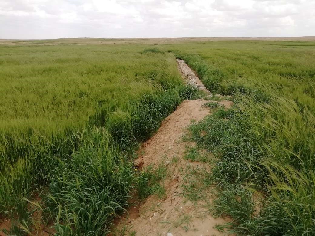
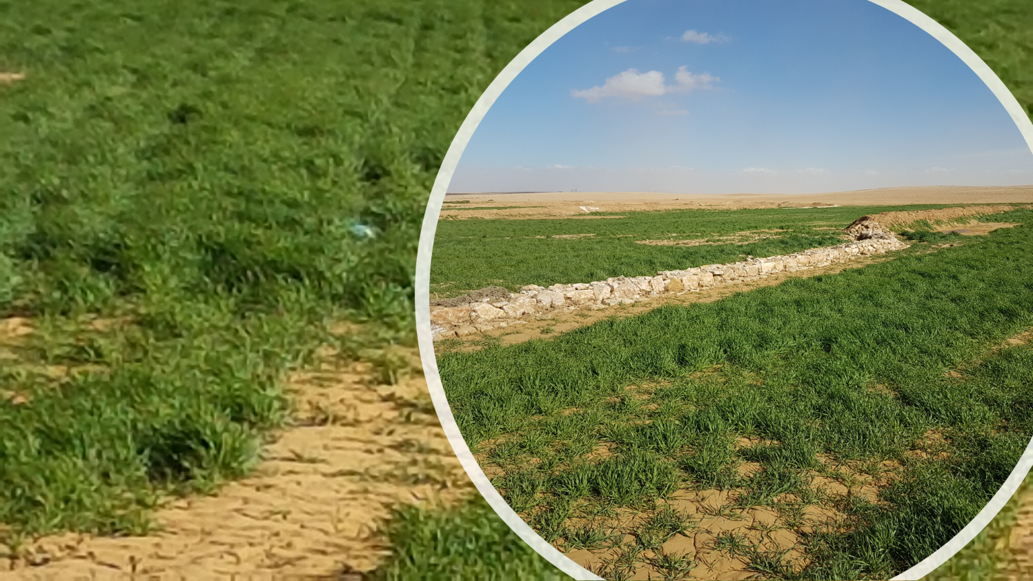
The technology diverts and spreads excess runoff over deep-soil flood plains. The technology comprises local gully-filling, grading/leveling of seed bed, and construction of a bund-and-spillway system creating several compartments for flood-irrigated agriculture.
2.2 Descripción detallada de la Tecnología
Descripción:
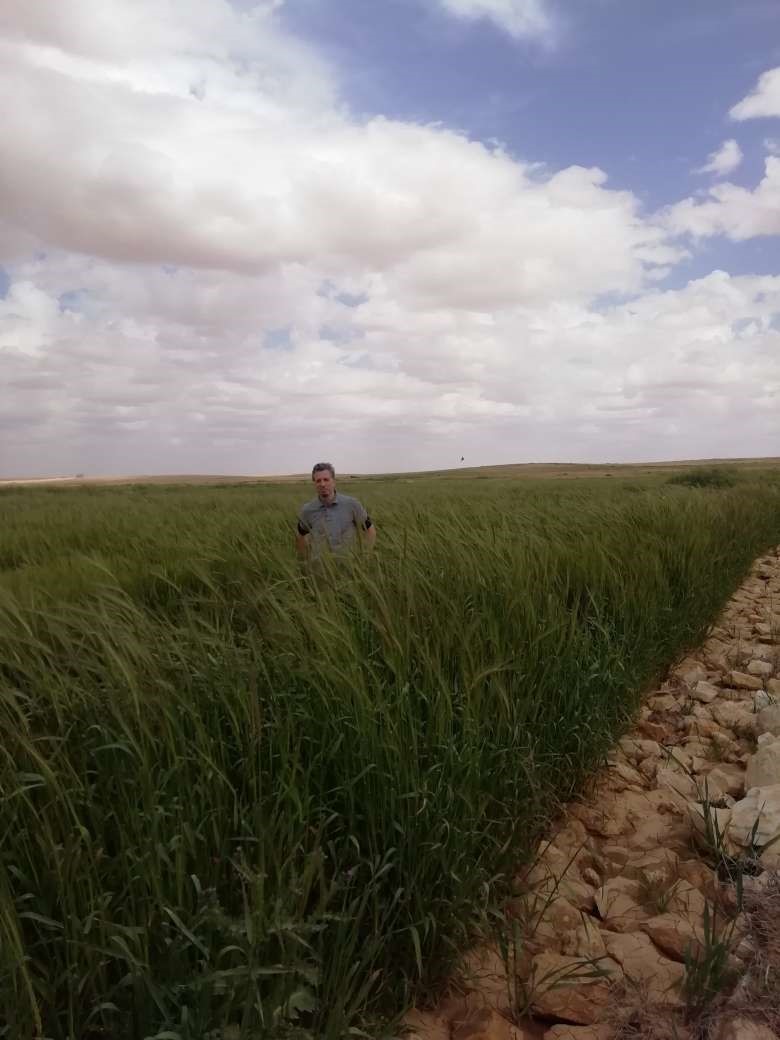
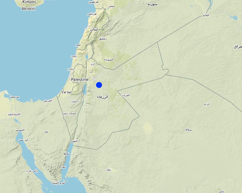
Arid drylands of Jordan receive less than 200mm average annual rainfall. The specific site is located close by Al Majeddyeh village, around 30km south-east of Amman. The average annual rainfall at the site is around 130mm. The average temperature is above 18 degrees Celsius. The human environment is characterized by agro-pastoralists. These are farmers that live in permanent houses but transport their livestock to graze. As consequence of the natural environment and mis-management (e.g. overgrazing) desertification has been an increasingly problem, not only from an environmental perspective (e.g. carbon stocking; lack of water), but also from an socio-economic perspective, because desertification leads to reduced productive lands, consequently resulting in less income for the rural population.
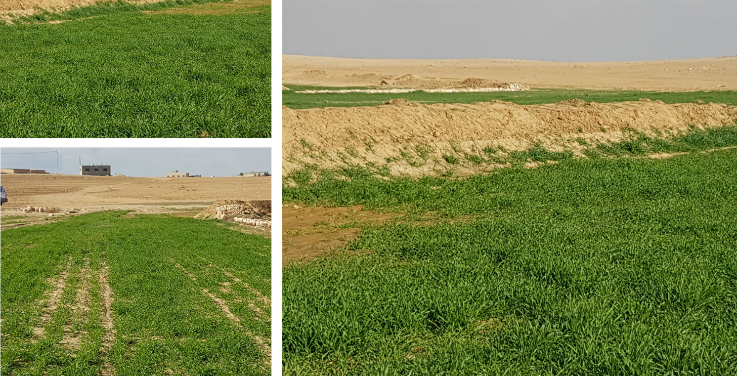
Therefore, the aim of the technology is to achieve high-yield agriculture through flood/macro-catchment water harvesting in arid environments commonly unsuitable for field crop agriculture, creating beneficial impact for local land users. The high yield barley is fed to the livestock (goats and sheeps) of the local agro-pastoralists. Applied in an integrated watershed approach, it meets agricultural demands and motivates sustainable dryland ecosystem management in the uplands. The Marab-technology has a buffering effect on extreme runoff through water retention, for further use in downstream areas, including the trapping of relative fertile sediments from upstream. As the Marab increases yields, it also improves the livelihood of the local population.
The Marab-technology is a macro-catchment water harvesting technology. The Marab is located in the natural depression of the watershed (10 square kilometres), therefore most of the water from the watershed is captured here, instead of being spilled away. Combining this natural depression with the construction of bunds and specific soil leveling, leads to decreased run-off, thus highly increased water infiltration and soil moisture. Thereby, the biomass-production increased as well.
The watershed is characterized by degraded lands upstream (720 ha), where low yield and subsidized barley cultivation is practiced, and by gullies. In a limited part (12 ha) of the upstream area, Vallerani micro-catchments are implemented as a pilot-plot. This might seem contradicting since upstream micro-catchment water harvesting decreases the water in the Marab downstream. However, the Vallerani micro-catchments also have beneficial impacts on the watershed and the Marab, such as flattening peak water flows, reducing erosion and providing fodder. The reduction in water run-off for the Marab as consequence of the Vallerani structures is not significant, due to the small size of the pilot area. But the relations between upstream and downstream should be taken into account.
Upstream watershed measures to buffer and/or avoid extreme runoff events (extreme downstream flooding) in the Marab such as micro-catchment water harvesting structures (Vallerani tractor plow system) and the out-planting of native shrub seedlings, as well as the stabilization of erosive gully systems through gully plugging and revegetation of side banks are advised to be taken before implementing the Marab technology downstream, as they safeguard and protect the Marab. But they are not further into account in this documentation.
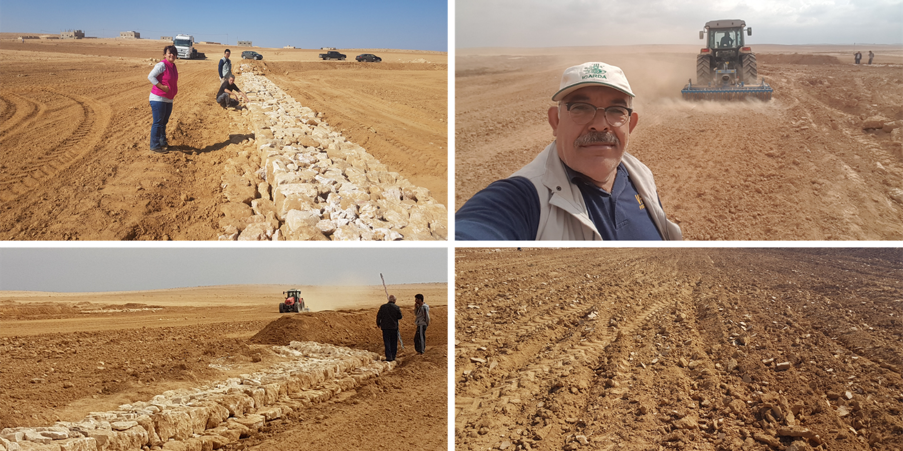
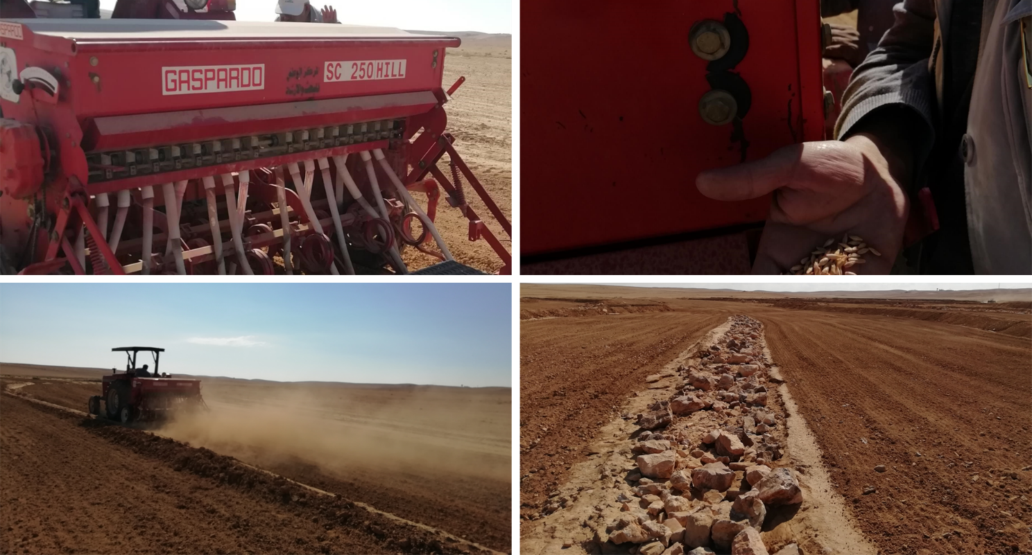
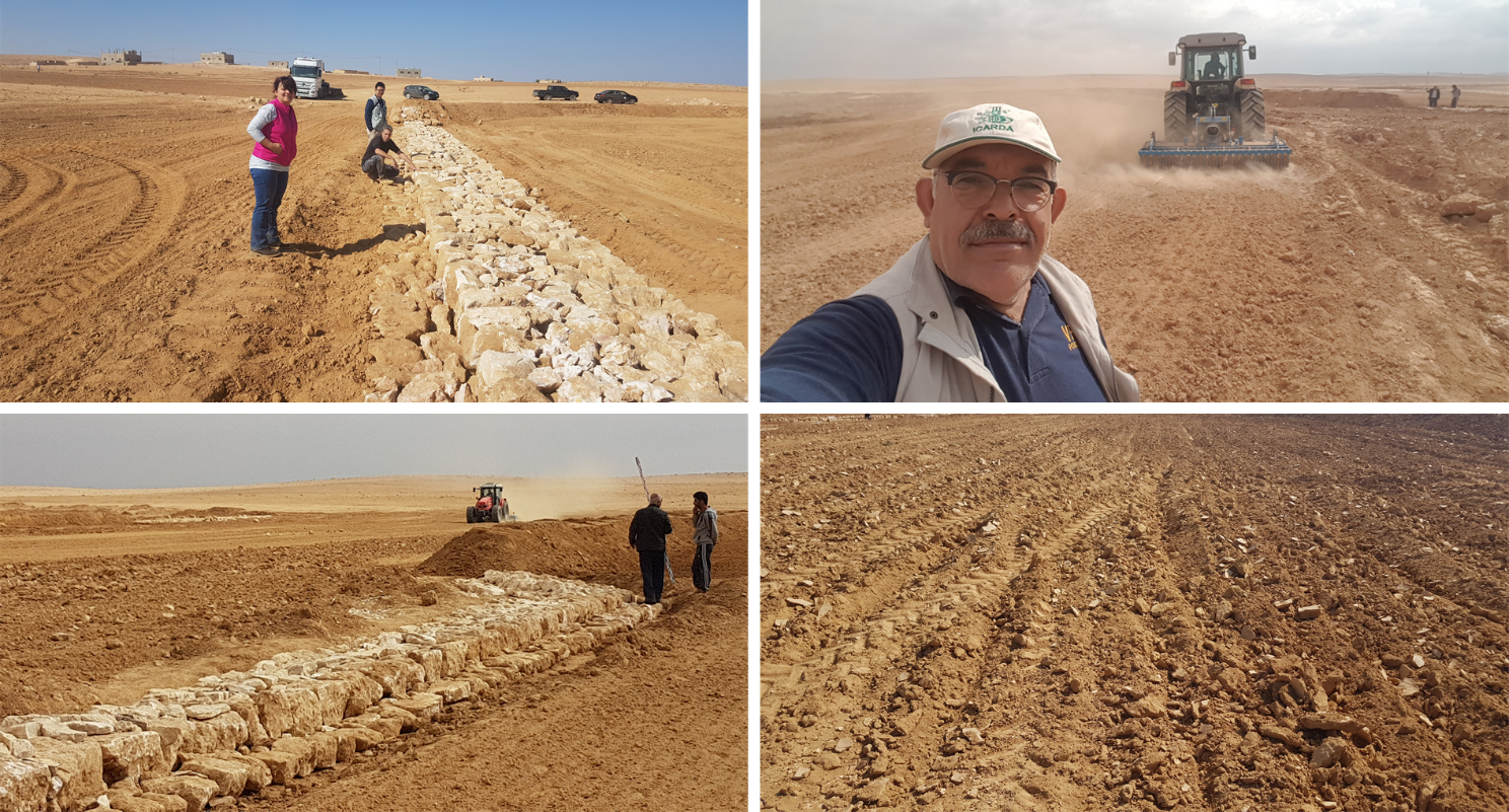
Establishment of the downstream Marab system includes:
•Local filling of downstream gull(system) with deep soil
•Leveling/grading of flood plains
•Construction of earth bunds
•Construction of the spillways (stone made)
• Seedbed preparation for planting annual crop such as barley
Marab agricultural production is high and stable. It can reach around 5-6 t ha-1 of barley, compared with the low and strongly varying yields of around 0.05-0.30 t ha-1 in traditionally, without macro water harvesting, cultivated barley. Marab barley produces grains (for fodder and reseeding purposes) and requires local inputs, such as fertilizer. The Marab mitigates downstream flooding and loss of sediments from the watershed. Local farmers applying the Marab technology are very satisfied, because of the extremely increased yield as consequence of the technology. However, as water is captured in the watershed, tensions may arise between the downstream (Marab) users and the upstream users.
2.3 Fotografías de la Tecnología
Galería de medios

2.5 País/ región/ lugares donde la Tecnología fue aplicada y que se hallan comprendidos por esta evaluación
País:
Jordania
Región/ Estado/ Provincia:
Al Jiza District
Especifique más el lugar :
Al Majeddyeh Village
Especifique la difusión de la Tecnología:
- aplicada en puntos específicos/ concentrada en un área pequeña
¿El/los sitio(s) de la Tecnología se ubica(n) en un área de protección permanente?
No
Map
×2.6 Fecha de la implementación
Indique año de implementación:
2017
2.7 Introducción de la Tecnología
Especifique cómo se introdujo la Tecnología:
- durante experimentos/ investigación
- mediante proyectos/ intervenciones externas
3. Clasificación de la Tecnología MST
3.1 Propósito(s) principal(es) de la Tecnología MST
- mejorar la producción
- reducir, prevenir, restaurar la degradación de la tierra
- reducir el riesgo de desastres naturales
- adaptarse al cambio climático/ extremos climáticos y sus impactos
- crear impacto económico benéfico
3.2 Tipo(s) actuales de uso de la tierra donde se aplica la Tecnología
Mezcla de tipos de uso de tierras dentro de la misma unidad de tierras: :
Sí
Especifique el uso combinado de tierras (cultivos/ pastoreo/ árboles):
- Agropastoralismo (incluyendo cultivo-ganado integrados)

Tierras cultivadas
- Cosecha anual
Cosechas anuales - Especifique cultivos:
- cereales - cebada
Número de temporadas de cultivo por año:
- 1
¿Se practica el intercultivo?
No
¿Se practica la rotación de cultivos?
No

Tierra de pastoreo
Pastoreo extenso:
- Pastoralismo semi-nómada
Pastoreo intensivo/ producción de forraje:
- Cortar y llevar/ cero pastoreo
Tipo de animal:
- cabras
- ovejas
¿Se practica el manejo integrado de cultivos - ganado?
No
3.3 ¿Cambió el uso de tierras debido a la implementación de la Tecnología?
¿Cambió el uso de tierras debido a la implementación de la Tecnología?
- No (Continúe con la pregunta 3.4)
3.4 Provisión de agua
Provisión de agua para la tierra donde se aplica la Tecnología:
- de secano
Comentarios:
The Marab facilitates uniform distribution of excess rainwater obtained from the upland (partly Vallerani micro-catchments) and the water is conveyed through rehabilitated gullies to the Marab. (Some) Micro catchments and rehabilitated gullies are essential to avoid damaging water peaks, harming the Marab-structures. The Marab is rainfed and naturally flood irrigated.
3.5 Grupo MST al que pertenece la Tecnología
- cobertura de suelo/ vegetal mejorada
- cosecha de agua
- diversión y drenaje de agua
3.6 Medidas MST que componen la Tecnología

medidas agronómicas
- A3: Tratamiento de superficie del suelo
- A4: Tratamiento de subsuperficie

medidas estructurales
- S2: Taludes, bancos
- S3: Acequias graduadas, canales, vías fluviales
3.7 Principales tipos de degradación de la tierra encarados con la Tecnología

erosión de suelos por agua
- Wt: pérdida de capa arable/ erosión de la superficie
- Wg: erosión en cárcavas
- Wo: efectos de degradación fuera del sitio

deterioro físico del suelo
- Pk: desmoronamiento y encostramiento

degradación biológica
- Bc: reducción de la cobertura vegetal del suelo
- Bq: reducción de la cantidad/ biomasa

degradación del agua
- Ha: aridificación
3.8 Prevención, reducción o restauración de la degradación de la tierra
Especifique la meta de la Tecnología con relación a la degradación de la tierra:
- reducir la degradación de la tierra
Comentarios:
Retaining surface runoff and locally infiltrating water through bunds increase soil moisture hence agricultural yield increases (e.g. biomass, vegetation cover) , soil crusting decreases (in some selected ponding areas it might increase) - and because of trapping top-soil sediments and residues from the uplands, soil fertility increases likewise.
4. Especificaciones técnicas, actividades de implementación, insumos y costos
4.1 Dibujo técnico de la Tecnología
Especificaciones técnicas (relacionadas al dibujo técnico):
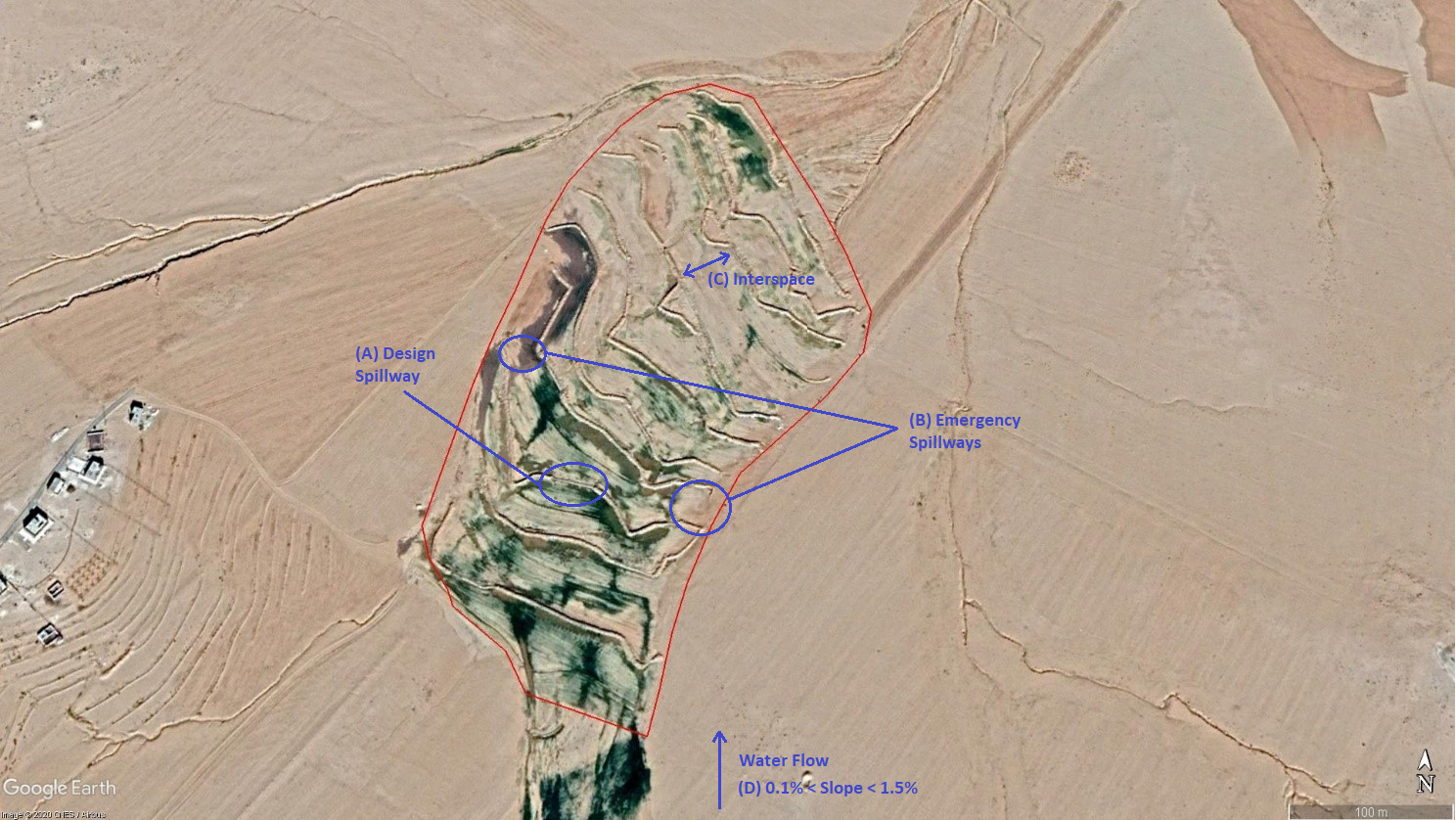
The overall Marab (reshaped flood plain) area is 10 hectares. The natural flood plain was leveled up to the sides; the natural slope in flow direction ranges between 0.1 and 1.5% (D). The later stone bund construction (soil relocation) and siltation/erosion processes over time develop a slight step-terraced bund compartment system, with the single compartments having much smaller slope than the overall Marab. At the sides, the levelled area slightly increases towards the natural terrain (natural terrain at the sides is around 0.1 to 0.3m higher compared with the leveled Marab). This avoids side outflow of water during design storms (*). Bund structures, along the contour, are built with a loader up to around 0.7 to 1.0m height and around 2.0 – 3.0m bottom width. The bunds are built with compaction through the loader. Interspace between the bunds is between 10-50 meters (C), depending on the local slope in the flow direction, having around 0.1 to 0.3m soil surface elevation difference between the bunds. Stone made design-spillways (A) are being constructed around the middle of each bund, with certain position change between the bund in downstream direction. Thus, spillways do not perfectly align with respect to the bund, but create a meandering flow around the center. The stone-protected design-spillways are designed to safely route at least the expected 2-5 year return period flood event. The Marab plain is not perfectly even, especially at the sides, to avoid water flowing around the bunds during design storms. However, the Marab-technology is also designed to cope with more extreme events, a storm of 5-10 return period, without significant damages. Therefore, there are emergency-spillways (**) implemented at the sides of each bund (B). These emergency-spillways allow excess water to flow out sideways rather than flow over the bund which would damage the structures. Note:
Based on above considerations and calculations bund spillway lengths reach 50-60m in the specific watershed.
* A design storm is a rainfall event that results in a flood event as water accumulates throughout the watershed. The Marab is designed to harvest the water optimally by (design) spill ways that keep the water in the Marab. A design storm relates to a certain return period. In general a longer return period (i.e. less frequent) accounts for a more intense event hence a more severe flooding event.
** An emergency spill way is a structure that is designed to discharge excess water coming from storms more extreme than the design storm (i.e. with less frequent storms). In practice this means that the Marab is protected from excess water.
Autor:
Joren Verbist (Extracted from Google Earth Pro on Jan 7th 2019)
Fecha:
19/12/2020
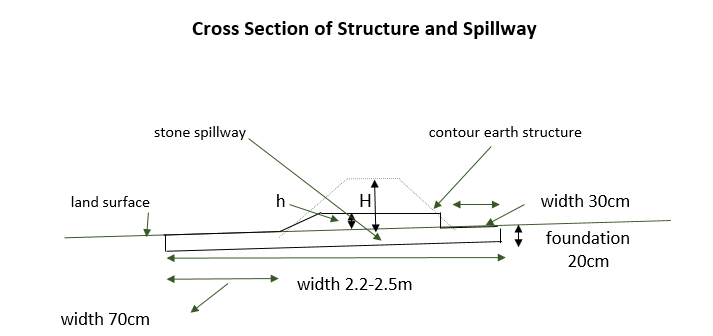
Especificaciones técnicas (relacionadas al dibujo técnico):
The cross-section shows the dimensions. Downstream of a bund the width is 70 centimeter. The foundation is 20 centimeter high. The upstream width is 30 centimeter. The total width of the bund varies between 2.2 meter and 2.5 meter.
Autor:
Stefan Strohmeier
Fecha:
01/07/2020
4.2 Información general sobre el cálculo de insumos y costos
Especifique cómo se calcularon los costos e insumos:
- por área de Tecnología
Indique tamaño y unidad de área:
10 ha
Especifique la moneda usada para calcular costos:
- USD
Indique el costo promedio del salario de trabajo contratado por día:
35
4.3 Actividades de establecimiento
| Actividad | Momento (estación) | |
|---|---|---|
| 1. | Implement upstream watershed rehabilitation measure (e.g. Upstream Vallerani micro water harvesting) | Prior of Marab-Technology construction |
| 2. | Implement gully rehabilitation measure (e.g. Midstream gully rehabilitation) | Prior of Marab-Technology construction |
| 3. | Marab site selection (flood plain): topographic assessment (slope, soil depth, etc.) and consideration of watershed hydrology (e.g. for bund and spillway design) | Before the rainy season |
| 4. | Grading/levelling of natural flood plain incl. gully fill (with soil material) | season (Aug. – Nov.) |
| 5. | Implement bund structures (based on step 4) | season (Aug. – Nov.) |
| 6. | Construct stone made design and emergence spillways (based on step 5) | season (Aug. – Nov.) |
| 7. | Preparation of compartmentalized agricultural fields (bund interspaces) for field crop agriculture | season (Aug. – Nov.) |
Comentarios:
The upstream measures as the Vallerani System and gully rehabilitation are strongly recommended but are not taken into account as costs in this documentation. Because this documentation focuses specifically on the Marab-technology.
4.4 Costos e insumos necesarios para el establecimiento
| Especifique insumo | Unidad | Cantidad | Costos por unidad | Costos totales por insumo | % de los costos cubiertos por los usuarios de las tierras | |
|---|---|---|---|---|---|---|
| Mano de obra | Local Workers | person-days | 50,0 | 35,0 | 1750,0 | |
| Mano de obra | Land Survey | person-days | 6,0 | 35,0 | 210,0 | |
| Mano de obra | Engineer (+assistance) | person-days | 15,0 | 50,0 | 750,0 | |
| Mano de obra | Drivers of heavy machinery | person-days | 12,0 | 35,0 | 420,0 | |
| Equipo | Grader | machine-days | 3,0 | 250,0 | 750,0 | |
| Equipo | Loader | machine-days | 10,0 | 250,0 | 2500,0 | |
| Equipo | Deep Plow | machine-days | 3,0 | 200,0 | 600,0 | |
| Equipo | Tractor (to pull the shallow and deep plow) | machine-days | 5,0 | 200,0 | 1000,0 | |
| Equipo | Shallow Plow | machine-days | 2,0 | 200,0 | 400,0 | |
| Equipo | Water Tank Truck | Tank | 1,0 | 50,0 | 50,0 | |
| Equipo | Small Equipment (Shovel, pickaxe, buckets) | Equipment | 1,0 | 200,0 | 200,0 | |
| Material de construcción | Stones | Kubic Metre | 200,0 | 10,0 | 2000,0 | |
| Otros | Transportation of heavy machinery | 1,0 | 2000,0 | 2000,0 | ||
| Otros | Security | 1,0 | 300,0 | 300,0 | ||
| Costos totales para establecer la Tecnología | 12930,0 | |||||
| Costos totales para establecer la Tecnología en USD | 12930,0 | |||||
Si el usuario de la tierra no cubrió el 100% de los costos, indique quién financió el resto del costo:
ICARDA and National Agricultural Research Centre (NARC)
Comentarios:
These costs are for establishment (so one-time) and are for the total Marab-technology i.e. 10 ha.
4.5 Actividades de establecimiento/ recurrentes
| Actividad | Momento/ frequencia | |
|---|---|---|
| 1. | Maintaining the structures based on observations and possible damages after the rainy season, so no clear maintenance plans | Before the rainy season (Oct. – Nov.)/upon observation |
Comentarios:
Excludes annual farming costs (e.g. seedbed preparation)
4.6 Costos e insumos necesarios para actividades de mantenimiento/ recurrentes (por año)
| Especifique insumo | Unidad | Cantidad | Costos por unidad | Costos totales por insumo | % de los costos cubiertos por los usuarios de las tierras | |
|---|---|---|---|---|---|---|
| Mano de obra | Engineer | person days per year | 2,0 | 50,0 | 100,0 | 100,0 |
| Mano de obra | Worker | person days per year | 6,0 | 35,0 | 210,0 | 100,0 |
| Equipo | Loader | machine days per year | 1,0 | 250,0 | 250,0 | 100,0 |
| Material de construcción | Stones | Kubic Metre | 10,0 | 10,0 | 100,0 | 100,0 |
| Indique los costos totales para mantenecer la Tecnología | 660,0 | |||||
| Costos totales para mantener la Tecnología en USD | 660,0 | |||||
Comentarios:
The costs of practicing agriculture (e.g. cost of seeds and fertilizer) are not taken into account, since these costs were also made before the implementation of this technology.
4.7 Factores más determinantes que afectan los costos:
Describa los factores más determinantes que afectan los costos:
The special and heavy machinery affect the cost significantly, since these were not available in the area. The implementation of the technology is labour intensive, therefore labour costs are significant as well. However, these costs are initially, so these specific costs are almost zero after establishment. In addition, all the maintenance is payed for by the land users. So, only the establishment was payed for by external parties.
5. Entorno natural y humano
5.1 Clima
Lluvia anual
- < 250 mm
- 251-500 mm
- 501-750 mm
- 751-1,000 mm
- 1,001-1,500 mm
- 1,501-2,000 mm
- 2,001-3,000 mm
- 3,001-4,000 mm
- > 4,000 mm
Especifique el promedio anual de lluvia (si lo conoce), en mm:
130,00
Especificaciones/ comentarios sobre la cantidad de lluvia:
In the specific site/dry areas of Jordan rainy season usually ranges from November until April
Queen Alia International Airport long-time avergae annual rainfall is around 150 mm (around 10km west of the site)
At the site a rainfall tipping bucket has been installed in 2016.
Indique el nombre de la estación metereológica de referencia considerada:
Queen Alia International Airport
Zona agroclimática
- árida
The maximum temperature usually occurres in August.
The average daily maximum temperature is 25.01 °C.
The average daily minimum temperature is 8.5 °C
5.2 Topografía
Pendientes en promedio:
- plana (0-2 %)
- ligera (3-5%)
- moderada (6-10%)
- ondulada (11-15%)
- accidentada (16-30%)
- empinada (31-60%)
- muy empinada (>60%)
Formaciones telúricas:
- meseta/ planicies
- cordilleras
- laderas montañosas
- laderas de cerro
- pies de monte
- fondo del valle
Zona altitudinal:
- 0-100 m s.n.m.
- 101-500 m s.n.m.
- 501-1,000 m s.n.m
- 1,001-1,500 m s.n.m
- 1,501-2,000 m s.n.m
- 2,001-2,500 m s.n.m
- 2,501-3,000 m s.n.m
- 3,001-4,000 m s.n.m
- > 4,000 m s.n.m
Indique si la Tecnología se aplica específicamente en:
- situaciones convexas
Comentarios y especificaciones adicionales sobre topografía :
The Marab itself is rather concave (depression shape) / natural depression. However, the bund structures are convex, spreading water over the field.
5.3 Suelos
Profundidad promedio del suelo:
- muy superficial (0-20 cm)
- superficial (21-50 cm)
- moderadamente profunda (51-80 cm)
- profunda (81-120 cm)
- muy profunda (>120 cm)
Textura del suelo (capa arable):
- mediana (limosa)
- fina/ pesada (arcilla)
Textura del suelo (> 20 cm debajo de la superficie):
- mediana (limosa)
Materia orgánica de capa arable:
- baja (<1%)
5.4 Disponibilidad y calidad de agua
Agua subterránea:
> 50 m
Disponibilidad de aguas superficiales:
pobre/ ninguna
Calidad de agua (sin tratar):
inutilizable
La calidad de agua se refiere a:
agua superficial
¿La salinidad del agua es un problema?
No
¿Se está llevando a cabo la inundación del área? :
Sí
Frecuencia:
frecuentemente
5.5 Biodiversidad
Diversidad de especies:
- baja
Diversidad de hábitats:
- baja
5.6 Las características de los usuarios de la tierra que aplican la Tecnología
Sedentario o nómada:
- Semi-nómada
Orientación del mercado del sistema de producción:
- mixta (subsistencia/ comercial)
Ingresos no agrarios:
- menos del 10% de todos los ingresos
Nivel relativo de riqueza:
- pobre
- promedio
Individuos o grupos:
- individual/ doméstico
Nivel de mecanización:
- mecanizado/motorizado
Género:
- hombres
Edad de los usuarios de la tierra:
- jóvenes
- personas de mediana edad
Indique otras características relevantes de los usuarios de las tierras:
The actual land users are often poor Jordanians or Syrian refugees. However, the owners of the livestock are relatively rich. The landowners are responsible for the maintenance of the intervention.
5.7 Área promedio de la tierra usada por usuarios de tierra que aplican la Tecnología
- < 0.5 ha
- 0.5-1 ha
- 1-2 ha
- 2-5 ha
- 5-15 ha
- 15-50 ha
- 50-100 ha
- 100-500 ha
- 500-1,000 ha
- 1,000-10,000 ha
- > 10,000 ha
¿Esto se considera de pequeña, mediana o gran escala (refiriéndose al contexto local)?
- escala mediana
Comentarios:
10ha
5.8 Tenencia de tierra, uso de tierra y derechos de uso de agua
Tenencia de tierra:
- individual, con título
Derechos de uso de tierra:
- arrendamiento
- individual
- NA
¿Los derechos del uso de la tierra se basan en un sistema legal tradicional?
Sí
5.9 Acceso a servicios e infraestructura
salud:
- pobre
- moderado
- bueno
educación:
- pobre
- moderado
- bueno
asistencia técnica:
- pobre
- moderado
- bueno
empleo (ej. fuera de la granja):
- pobre
- moderado
- bueno
mercados:
- pobre
- moderado
- bueno
energía:
- pobre
- moderado
- bueno
caminos y transporte:
- pobre
- moderado
- bueno
agua potable y saneamiento:
- pobre
- moderado
- bueno
servicios financieros:
- pobre
- moderado
- bueno
6. Impactos y comentarios para concluir
6.1 Impactos in situ demostrados por la Tecnología
Impactos socioeconómicos
Producción
producción de cultivo
Comentarios/ especifique:
The crops produced are used as fodder
producción de forraje
Cantidad antes de MST:
0.05ton/ha
Cantidad luego de MST:
5ton/ha
Comentarios/ especifique:
The production of the fodder is increased as the barley yield is mostly used to feed animals and also the stubble is grazed.
calidad de forraje
Comentarios/ especifique:
The barley is fed to the livestock
área de producción
Comentarios/ especifique:
Due to the bunds (but very limited and inevitable)
manejo de tierras
Ingreso y costos
gastos en insumos agrícolas
Comentarios/ especifique:
Expenses are slightly increased due to possible maintenance of the Marab. However, the increased yield justifies this.
ingreso agrario
carga de trabajo
Comentarios/ especifique:
Due to possible maintenance
Impactos socioculturales
seguridad alimentaria/ autosuficiencia
MST/ conocimiento de la degradación de la tierra
Comentarios/ especifique:
During the construction, local community were hired as workers, this has significantly boosted their knowlegde about SLM.
Impactos ecológicos
Ciclo de agua/ escurrimiento de sedimento
cosecha/ recolección de agua
escurrimiento superficial
drenaje de agua en exceso
nivel freático/ acuífero
Suelo
humedad del suelo
cubierta del suelo
pérdida de suelo
acumulación de suelo
encostramiento/ sellado de suelo
materia orgánica debajo del suelo C
Biodiversidad: vegetación, animales
Cubierta vegetal
biomasa/ sobre suelo C
Reducción de riesgos de desastres y riesgos climáticos
impactos de inundaciones
impactos de sequías
6.2 Impactos fuera del sitio demostrados por la Tecnología
inundaciones río abajo
Comentarios/ especifique:
Reduced downstream flooding is desired
colmatación río abajo
Comentarios/ especifique:
Reduced downstream siltation is desired
6.3 Exposición y sensibilidad de la Tecnología al cambio climático gradual y a extremos relacionados al clima/ desastres (desde la percepción de los usuarios de tierras)
Cambio climático gradual
Cambio climático gradual
| Estación | Incremento o reducción | ¿Cómo es que la tecnología soporta esto? | |
|---|---|---|---|
| lluvia anual | disminuyó | bien |
Extremos (desastres) relacionados al clima
Desastres climatológicos:
| ¿Cómo es que la tecnología soporta esto? | |
|---|---|
| tormenta de lluvia local | muy bien |
Desastres hidrológicos
| ¿Cómo es que la tecnología soporta esto? | |
|---|---|
| inundación repentina | muy bien |
6.4 Análisis costo-beneficio
¿Cómo se comparan los beneficios con los costos de establecimiento (desde la perspectiva de los usuarios de tierra)?
Ingresos a corto plazo:
ligeramente negativo
Ingresos a largo plazo:
positivo
¿Cómo se comparan los beneficios con los costos de mantenimiento/ recurrentes (desde la perspectiva de los usuarios de tierra)?
Ingresos a corto plazo:
positivo
Ingresos a largo plazo:
muy positivo
Comentarios:
The initial investment is quite large. Therefore, the short term returns is classified as slightly negative. After some seasons with good (stable) crop yield the return of investment is positive. Long term benefits are classified positively.
6.5 Adopción de la Tecnología
- 1-10%
Si tiene la información disponible, cuantifique (número de hogares y/o área cubierta):
These are some farmers that live near the Marab. They try to copy the Marab in their fields.
De todos quienes adoptaron la Tecnología, ¿cuántos lo hicieron espontáneamente, por ej. sin recibir nada de incentivos/ materiales:
- 91-100%
Comentarios:
The local farmers like the technology and acknowledge its positive impacts. They would like to have a Marab themselves (even if their locally owned lands are not suitable in many cases). Local agro-pastoralists copy and apply parts of the technology (especially the bund
system). However, it strongly recommended that implementing a Marab-technology is done as a community-based project/intervention; the Marab technology should be part of an integrated watershed management plan, located at the most suitable location for the entire community.
6.6 Adaptación
¿La tecnología fue modificada recientemente para adaptarse a las condiciones cambiantes?
Sí
Si fuera así, indique a qué condiciones cambiantes se adaptó:
- cambios climáticos / extremos
Especifique la adaptación de la Tecnología (diseño, material/ especies, etc.):
The spillway design can be adapted to variable surface runoff occurrence (affected by climate change).
6.7 Fuerzas/ ventajas/ oportunidades de la Tecnología
| Fuerzas/ ventajas/ oportunidades desde la perspectiva del usuario de la tierra |
|---|
| The farmers highly appreciate the improved economic situation as consequence of the increased yield. |
| A strength of the Marab technology is that water is harvested and minimally spilled away, preventing top-soil erosion and accumulating soil organic matter consequently preserving soil fertility. |
| The crop produces grains: can be (partially) used for re-seeding in the coming seasons; economic gain + increase resilience. |
| Fuerzas/ ventajas/ oportunidades desde la perspectiva del compilador o de otra persona de referencia clave |
|---|
| Economic improvement through targeted agricultural interventions in the most suitable location(s) of a watershed. This aims at decreasing the pressure on the fragile dry land ecosystem. The locally increased yield raises awareness on non-sufficient field crop agriculture in uplands (commonly achieved) and might increase the willingness for more nature-based sustainable land management measures in the less fertile and runoff generating (more vulnerable uplands) parts of the watershed. Therefore, the Marab technology could be a starting point for a watershed rehabilitation initiative. |
| The Marab technology creates an opportunity for multiple crop introduction (due to natural flood irrigation) – aside from barley monoculture (agro-diversity). |
| Increased water infiltration conserves water and might lead to deep percolation (groundwater recharge). |
6.8 Debilidades/ desventajas/ riesgos de la Tecnología y formas de sobreponerse a ellos
| Debilidades/ desventajas/ riesgos desde la perspectiva del usuario de la tierra | ¿Cómo sobreponerse a ellas? |
|---|---|
| The Marab depends on upstream water users; can lead to increased tensions | Agreement among the community - conducting contacts/contracts among upstream and downstream farmers. Joint watershed management and benefit share could be mediate these tension. And might even lead to watershed rehabilitation. |
| High initial investment and partially high maintenance costs (including machinery) | Once the implementation is linked with larger environmental benefits – communities might receive funds from the government or international donors. |
| Loss of cultivation area where the bunds are placed | Unavoidable. However, the gain of interspaces exceeds these losses several times. |
| Debilidades/ desventajas/ riesgos desde la perspectiva del compilador o de otra persona de referencia clave | ¿Cómo sobreponerse a ellas? |
|---|---|
| Tensions among multiple actors in the watershed (selection of Marab area) | Develop institutions that could avoid these tensions by establishing agreements, contracts, rules, or regulations. |
| Heavy machinery in a vulnerable ecosystems – can induce other requests/use by locals (improper use) | Targeted policies in place & enforcements |
| Increasing wealth inequality between farmers and/or communities. | Creation of institutions, which assure fair distribution. This would benefit the whole watershed. |
7. Referencias y vínculos
7.1 Métodos/ fuentes de información
- visitas de campo, encuestas de campo
- entrevistas con usuarios de tierras
- entrevistas con especialistas/ expertos en MST
- compilación de informes y otra documentación existente
¿Cuándo se compilaron los datos (en el campo)?
15/04/2020
7.2 Vínculos a las publicaciones disponibles
Título, autor, año, ISBN:
Strohmeier, S. (2017). Dimensioning of Marab in Majidyya.
Título, autor, año, ISBN:
Strohmeier, S. (2017). Watershed Restoration in Baia Areas of Jordan Technology Packages for Controlling and Monitoring Gully Erosion.
¿Dónde se halla disponible? ¿Costo?
https://mel.cgiar.org/projects/jordan-watershed-restoration-project
Título, autor, año, ISBN:
Mira Haddad, Stefan Strohmeier. (12/12/2017). Treated upland areas map. Jordan: International Center for Agricultural Research in the Dry Areas (ICARDA).
¿Dónde se halla disponible? ¿Costo?
https://hdl.handle.net/20.500.11766/9108
Título, autor, año, ISBN:
Stefan Strohmeier, Mira Haddad, Ismail Shukri. (8/11/2018). Marab - water harvesting based agriculture.
¿Dónde se halla disponible? ¿Costo?
https://hdl.handle.net/20.500.11766/9069
Título, autor, año, ISBN:
Boubaker Dhehibi, Mira Haddad, Stefan Strohmeier, Masnat El-Hiary. (24/7/2020). Enhancing a Traditional Water Harvesting Technique in Jordan’s Agro-pastoral Farming System. Lebanon: International Center for Agricultural Research in the Dry Areas (ICARDA).
¿Dónde se halla disponible? ¿Costo?
https://hdl.handle.net/20.500.11766/11506
7.3 Vínculos a la información relevante disponible en línea
Título/ descripción:
WATER HARVESTING FOR RESTORING RANGELANDS IN JORDAN
URL:
https://www.icarda.org/media/drywire/water-harvesting-restoring-rangelands-jordan
Vínculos y módulos
Expandir todo Colapsar todosVínculos
No hay vínculos
Módulos
No se hallaron módulos