Marab - Water Harvesting Based Floodplain Agriculture [ຈໍແດນ]
- ການສ້າງ:
- ປັບປູງ:
- ຜູ້ສັງລວມຂໍ້ມູນ: Joren Verbist
- ບັນນາທິການ: Mira Haddad, Enrico Bonaiuti
- ຜູ້ທົບທວນຄືນ: Rima Mekdaschi Studer
Marab in Arabic “المرب”
technologies_5770 - ຈໍແດນ
ເບິ່ງພາກສ່ວນ
ຂະຫຍາຍທັງໝົດ ຍຸບທັງໝົດ1. ຂໍ້ມູນທົ່ວໄປ
1.2 ຂໍ້ມູນ ການຕິດຕໍ່ພົວພັນ ຂອງບຸກຄົນທີ່ສໍາຄັນ ແລະ ສະຖາບັນ ທີ່ມີສ່ວນຮ່ວມ ໃນການປະເມີນເອກກະສານ ເຕັກໂນໂລຢີ
ບັນດາຜູ້ຕອບແບບສອບຖາມທີ່ສໍາຄັນ ()
ຜຸ້ຊ່ຽວຊານ ດ້ານການຄຸ້ມຄອງ ທີ່ດິນແບບຍືນຍົງ:
Strohmeier Stefan
International Center of Agriculture Research in the Dry Areas (ICARDA)
ຈໍແດນ
ຜຸ້ຊ່ຽວຊານ ດ້ານການຄຸ້ມຄອງ ທີ່ດິນແບບຍືນຍົງ:
ຜຸ້ຊ່ຽວຊານ ດ້ານການຄຸ້ມຄອງ ທີ່ດິນແບບຍືນຍົງ:
Natural Resources Economist Social, Economy & Policy Research:
Dhehibi Boubaker
International Center of Agriculture Research in the Dry Areas (ICARDA)
ຈໍແດນ
ຊື່ໂຄງການ ທີ່ອໍານວຍຄວາມສະດວກ ໃນການສ້າງເອກກະສານ/ປະເມີນ ເຕັກໂນໂລຢີ (ຖ້າກ່ຽວຂ້ອງ)
ICARDA Institutional Knowledge Management Initiativeຊື່ສະຖາບັນ (ຫຼາຍສະຖາບັນ) ທີ່ອໍານວຍຄວາມສະດວກ ໃນການສ້າງເອກກະສານ / ປະເມີນ ເຕັກໂນໂລຢີ (ຖ້າກ່ຽວຂ້ອງ)
International Center for Agricultural Research in the Dry Areas (ICARDA) - ລີບານອນ1.3 ເງື່ອນໄຂ ກ່ຽວກັບ ການນໍາໃຊ້ຂໍ້ມູນເອກະສານ ທີ່ສ້າງຂື້ນ ໂດຍຜ່ານ ອົງການພາບລວມຂອງໂລກ ທາງດ້ານແນວທາງ ແລະ ເຕັກໂນໂລຢີ ຂອງການອານຸລັກ ທໍາມະຊາດ (WOCAT)
ຜູ້ປ້ອນຂໍ້ມູນ ແລະ ບຸກຄົນສຳຄັນ ທີ່ໃຫ້ຂໍ້ມູນ (ຫຼາຍ) ຍິນຍອມ ຕາມເງື່ອນໄຂ ໃນການນຳໃຊ້ຂໍ້ມູນ ເພື່ອສ້າງເປັນເອກກະສານຂອງ WOCAT:
ແມ່ນ
1.4 ແຈ້ງການວ່າ ດ້ວຍຄວາມຍືນຍົງຂອງ ເຕັກໂນໂລຢີ
ການນໍາໃຊ້ ເຕັກໂນໂລຢີ ດັ່ງກ່າວໄດ້ອະທິບາຍ ເຖິງບັນຫາ ກ່ຽວກັບ ການເຊື່ອມໂຊມຂອງດິນບໍ? ຖ້າບໍ່ດັ່ງນັ້ນ ມັນບໍ່ສາມາດ ຢັ້ງຢືນໄດ້ວ່າ ເປັນເຕັກໂນໂລຊີ ໃນການຄຸ້ມຄອງ ທີ່ດິນແບບຍືນຍົງ? :
ບໍ່ແມ່ນ
ຄວາມຄິດເຫັນ:
This technology conserves soil and water; it reduces surface water and sediment losses from dryland watersheds. The technology is located in downstream/lowland floodplains, and ideally, it is implemented in an integrated watershed approach. In the present case study, the ‘Marab’ is linked with two main upstream measures: Upland micro-water harvesting (Vallerani system) and gully/channel measures (gully plugs)
2. ການອະທິບາຍ ເຕັກໂນໂລຢີ ຂອງການຄຸ້ມຄອງ ທີ່ດິນແບບຍືນຍົງ
2.1 ຄໍາອະທິບາຍສັ້ນຂອງ ເຕັກໂນໂລຢີ
ການກຳໜົດຄວາມໝາຍ ຂອງເຕັກໂນໂລຢີ:
The Marab is a local downstream water harvesting measure in an integrated watershed context, where up/midstream users and applied land management practices affect the Marab.
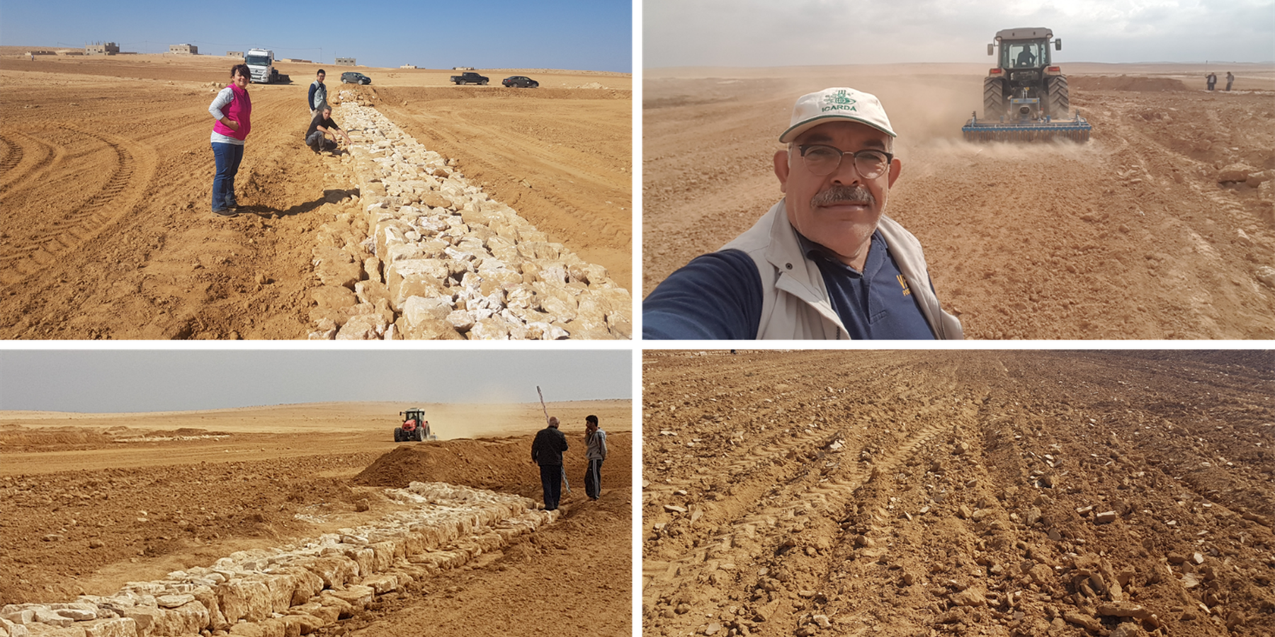
The technology diverts and spreads excess runoff over deep-soil flood plains. The technology comprises local gully-filling, grading/leveling of seed bed, and construction of a bund-and-spillway system creating several compartments for flood-irrigated agriculture.
2.2 ການອະທິບາຍ ລາຍລະອຽດ ຂອງເຕັກໂນໂລຢີ
ການພັນລະນາ:
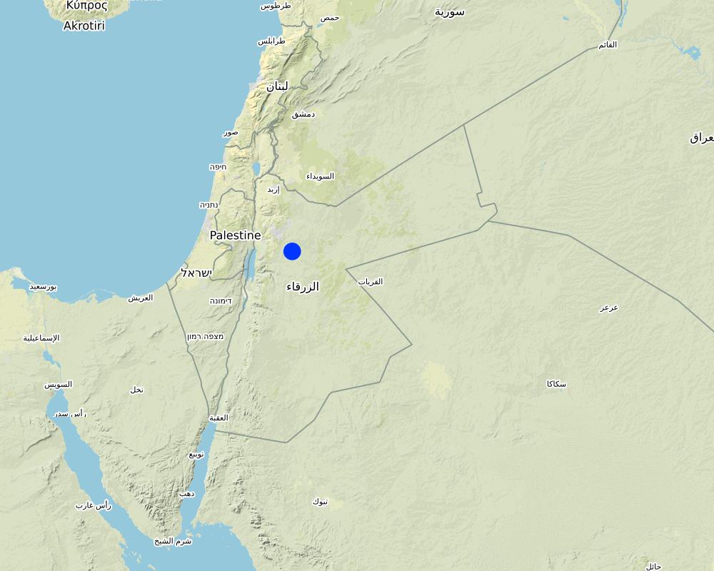
Arid drylands of Jordan receive less than 200mm average annual rainfall. The specific site is located close by Al Majeddyeh village, around 30km south-east of Amman. The average annual rainfall at the site is around 130mm. The average temperature is above 18 degrees Celsius. The human environment is characterized by agro-pastoralists. These are farmers that live in permanent houses but transport their livestock to graze. As consequence of the natural environment and mis-management (e.g. overgrazing) desertification has been an increasingly problem, not only from an environmental perspective (e.g. carbon stocking; lack of water), but also from an socio-economic perspective, because desertification leads to reduced productive lands, consequently resulting in less income for the rural population.
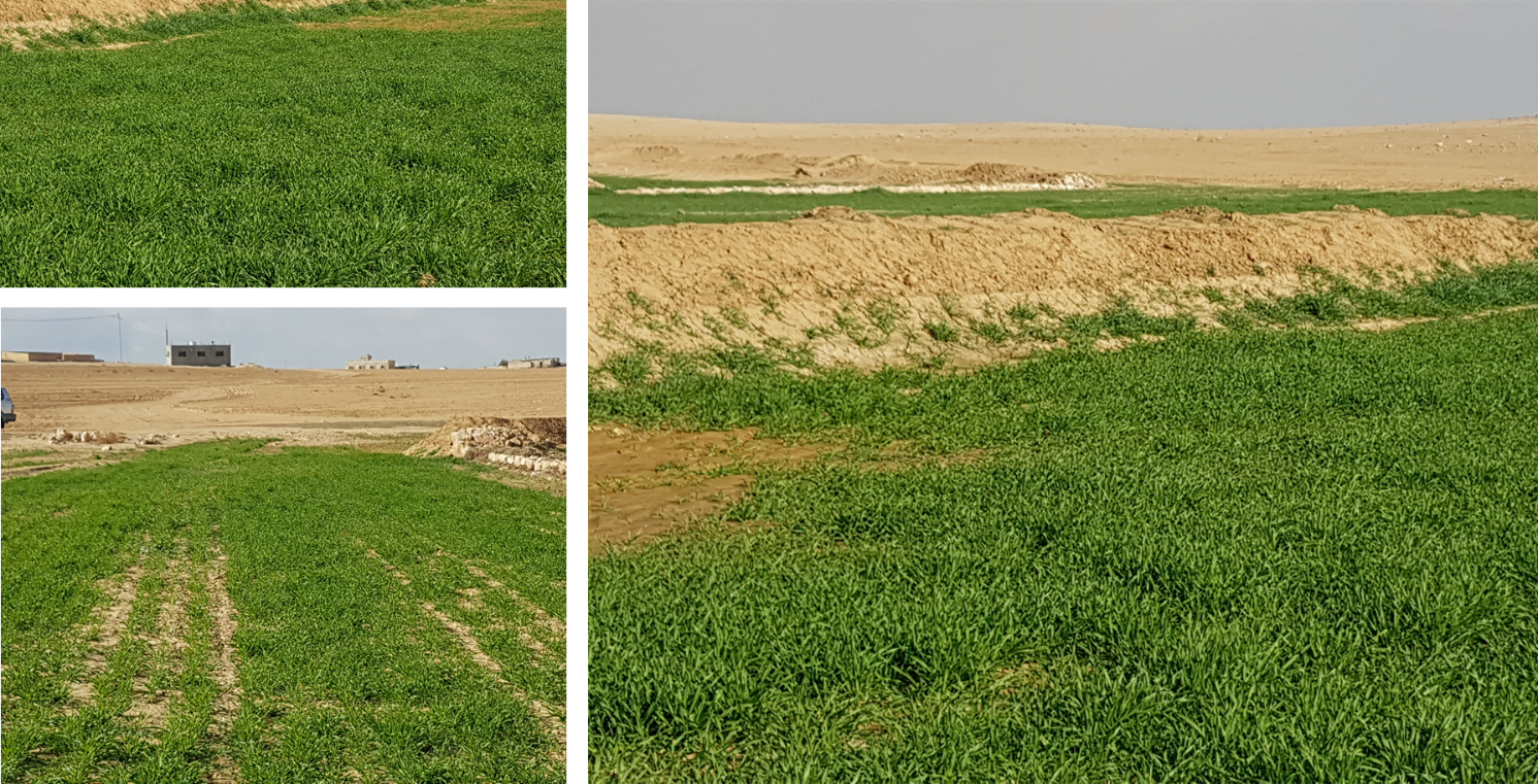
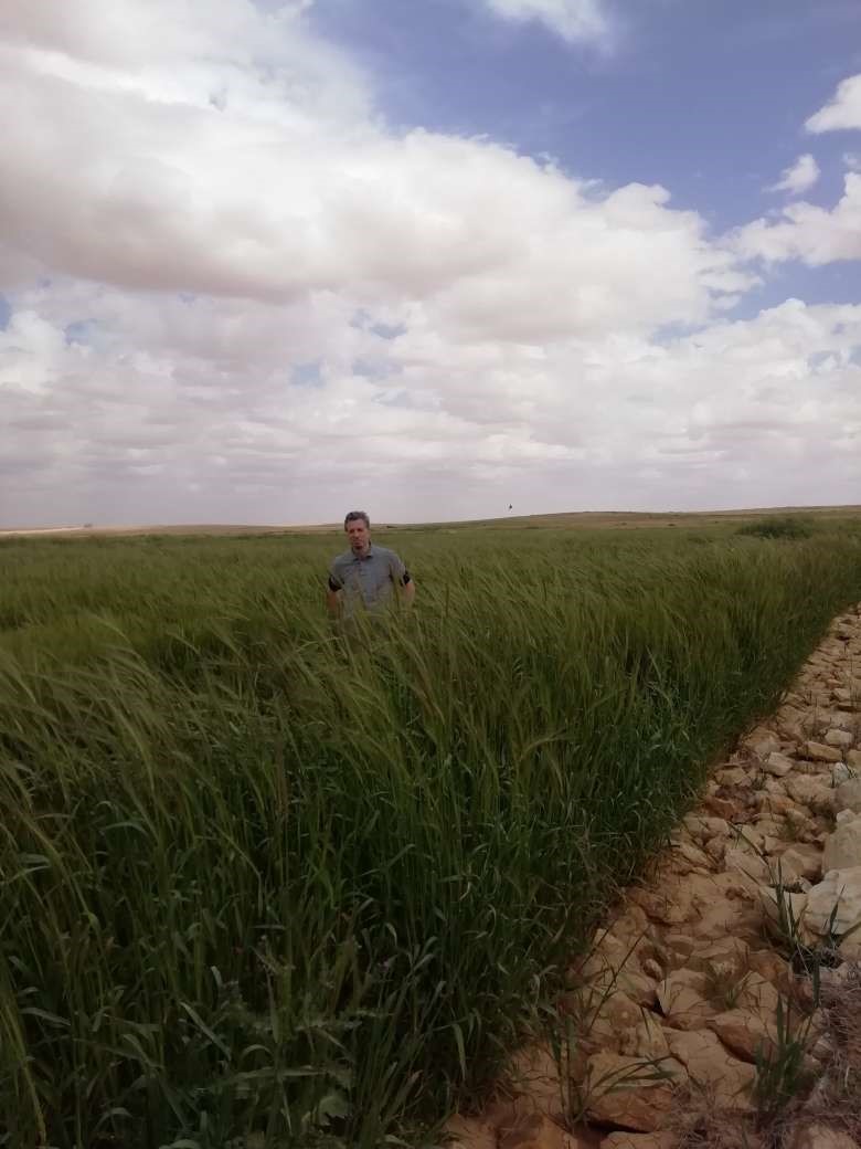
Therefore, the aim of the technology is to achieve high-yield agriculture through flood/macro-catchment water harvesting in arid environments commonly unsuitable for field crop agriculture, creating beneficial impact for local land users. The high yield barley is fed to the livestock (goats and sheeps) of the local agro-pastoralists. Applied in an integrated watershed approach, it meets agricultural demands and motivates sustainable dryland ecosystem management in the uplands. The Marab-technology has a buffering effect on extreme runoff through water retention, for further use in downstream areas, including the trapping of relative fertile sediments from upstream. As the Marab increases yields, it also improves the livelihood of the local population.
The Marab-technology is a macro-catchment water harvesting technology. The Marab is located in the natural depression of the watershed (10 square kilometres), therefore most of the water from the watershed is captured here, instead of being spilled away. Combining this natural depression with the construction of bunds and specific soil leveling, leads to decreased run-off, thus highly increased water infiltration and soil moisture. Thereby, the biomass-production increased as well.
The watershed is characterized by degraded lands upstream (720 ha), where low yield and subsidized barley cultivation is practiced, and by gullies. In a limited part (12 ha) of the upstream area, Vallerani micro-catchments are implemented as a pilot-plot. This might seem contradicting since upstream micro-catchment water harvesting decreases the water in the Marab downstream. However, the Vallerani micro-catchments also have beneficial impacts on the watershed and the Marab, such as flattening peak water flows, reducing erosion and providing fodder. The reduction in water run-off for the Marab as consequence of the Vallerani structures is not significant, due to the small size of the pilot area. But the relations between upstream and downstream should be taken into account.
Upstream watershed measures to buffer and/or avoid extreme runoff events (extreme downstream flooding) in the Marab such as micro-catchment water harvesting structures (Vallerani tractor plow system) and the out-planting of native shrub seedlings, as well as the stabilization of erosive gully systems through gully plugging and revegetation of side banks are advised to be taken before implementing the Marab technology downstream, as they safeguard and protect the Marab. But they are not further into account in this documentation.
Establishment of the downstream Marab system includes:
•Local filling of downstream gull(system) with deep soil
•Leveling/grading of flood plains
•Construction of earth bunds
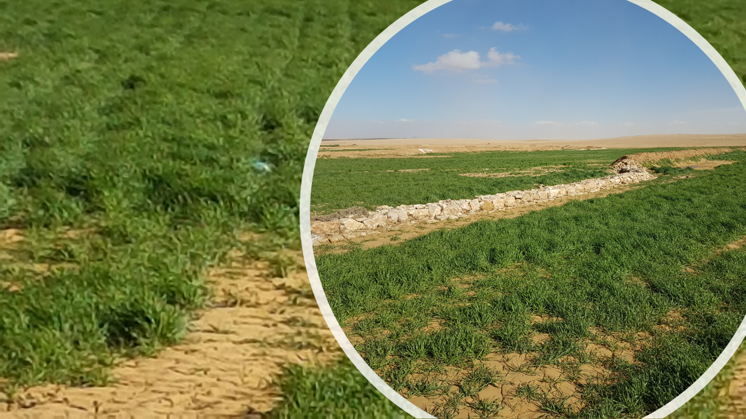
•Construction of the spillways (stone made)
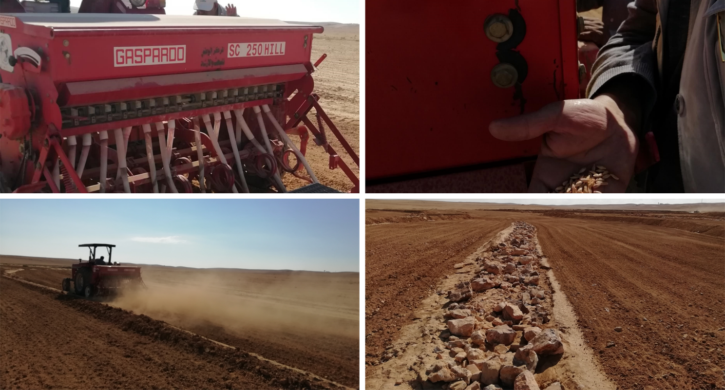
• Seedbed preparation for planting annual crop such as barley
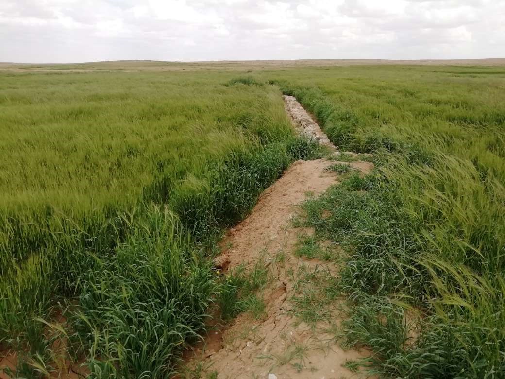
Marab agricultural production is high and stable. It can reach around 5-6 t ha-1 of barley, compared with the low and strongly varying yields of around 0.05-0.30 t ha-1 in traditionally, without macro water harvesting, cultivated barley. Marab barley produces grains (for fodder and reseeding purposes) and requires local inputs, such as fertilizer. The Marab mitigates downstream flooding and loss of sediments from the watershed. Local farmers applying the Marab technology are very satisfied, because of the extremely increased yield as consequence of the technology. However, as water is captured in the watershed, tensions may arise between the downstream (Marab) users and the upstream users.
2.3 ຮູບພາບຂອງເຕັກໂນໂລຢີ
ສື່ຮູບພາບ

2.5 ປະເທດ / ເຂດ / ສະຖານທີ່ບ່ອນທີ່ ເຕັກໂນໂລຢີ ໄດ້ຮັບການນໍາໃຊ້ ແລະ ທີ່ຖືກປົກຄຸມດ້ວຍການປະເມີນຜົນ
ປະເທດ:
ຈໍແດນ
ພາກພື້ນ / ລັດ / ແຂວງ:
Al Jiza District
ຂໍ້ມູນເພີ່ມເຕີມຂອງສະຖານທີ່:
Al Majeddyeh Village
ໃຫ້ລະບຸ ການແຜ່ຂະຫຍາຍ ເຕັກໂນໂລຢີ:
- ນໍາໃຊ້ໃນຈຸດສະເພາະ / ແນໃສ່ນໍາໃຊ້ໃນພື້ນທີ່ຂະໜາດນ້ອຍ
ສ່ວນຫຼາຍສະຖານທີ່ຕັ້ງຂອງເຕັກໂນໂລຢີ ແມ່ນ ຢູ່ໃນເຂດພື້ນທີ່ສະຫງວນບໍ?
ບໍ່ແມ່ນ
Map
×2.6 ວັນທີໃນການຈັດຕັ້ງປະຕິບັດ
ໃຫ້ລະບຸປີ ໃນການຈັດຕັ້ງປະຕິບັດ:
2017
2.7 ການນໍາສະເໜີ ເຕັກໂນໂລຢີ
ໃຫ້ລະບຸ ເຕັກໂນໂລຢີ ໄດ້ຖືກຈັດຕັ້ງປະຕິບັດຄືແນວໃດ?
- ໃນໄລຍະການທົດລອງ / ການຄົ້ນຄວ້າ
- ໂດຍຜ່ານໂຄງການ / ການຊ່ວຍເຫຼືອຈາກພາຍນອກ
3. ການໃຈ້ແຍກ ເຕັກໂນໂລຢີ ໃນການຄຸ້ມຄອງ ດິນແບບຍືນຍົງ
3.1 ຈຸດປະສົງຫຼັກ (ຫຼາຍ) ຂອງເຕັກໂນໂລຢີ
- ປັບປຸງ ການຜະລິດ
- ຫຼຸດຜ່ອນ, ປ້ອງກັນ, ຟື້ນຟູ ການເຊື່ອມໂຊມຂອງດິນ
- ຫຼຸດຜ່ອນຄວາມສ່ຽງ ທາງໄພພິບັດທໍາມະຊາດ
- ປັບຕົວຕໍ່ກັບການປ່ຽນແປງດິນຟ້າອາກາດ / ທີ່ຮ້າຍແຮງ ແລະ ຜົນກະທົບ
- ສ້າງຜົນກະທົບ ທາງເສດຖະກິດ ທີ່ເປັນປະໂຫຍດ
3.2 ປະເພດການນໍາໃຊ້ທີ່ດິນ ໃນປະຈຸບັນ() ທີ່ເຕັກໂນໂລຢີ ໄດ້ຖືກນໍາໃຊ້
ການນຳໃຊ້ທີ່ດິນ ປະສົມພາຍໃນພື້ນທີ່ດຽວກັນ:
ແມ່ນ
ລະບຸການນຳໃຊ້ທີ່ດິນແບບປະສົມ (ຜົນລະປູກ / ທົ່ງຫຍ້າລ້ຽງສັດ / ຕົ້ນໄມ້):
- ກະສິກໍາແບບປະສົມປະສານ (ລວມທັງ ການລ້ຽງສັດ-ປຸກຝັງ)

ດິນທີ່ປູກພືດ
- ການປູກພືດປະຈໍາປີ
ການປູກພືດປະຈຳປີ - ລະບຸປະເພດພືດ:
- ທັນຍາພືດ-ເຂົ້າບາເລ້
ຈໍານວນ ລະດູການ ປູກໃນປີໜຶ່ງ:
- 1
ມີການເຝືກປູກພືດແບບສັບຫວ່າງບໍ່?
ບໍ່ແມ່ນ
ມີການເຝືກປູກພືດແບບໝູນວຽນບໍ່?
ບໍ່ແມ່ນ

ທົ່ງຫຍ້າລ້ຽງສັດ
ການລ້ຽງສັດແບບປ່ອຍ ຕາມທຳມະຊາດ:
- ການລ້ຽງສັດແບບເຄີ່ງປ່ອຍ
ທົ່ງຫຍ້າລ້ຽງສັດແບບສຸມ / ການຜະລິດອາຫານສັດ:
- ຕັດຫຍ້າ ແລະ ຂົນຫຍ້າ / ບໍ່ມີທົ່ງຫຍ້າທໍາມະຊາດ
ປະເພດສັດ:
- ແບ້
- ແກະ
ແມ່ນການເຝືກຄຸ້ມຄອງ ການປູກພືດປະສົມປະສານ ກັບການລ້ຽງສັດບໍ່?
ບໍ່ແມ່ນ
3.3 ການນຳໃຊ້ທີ່ດິນ ມີການປ່ຽນແປງຍ້ອນການຈັດຕັ້ງທົດລອງເຕັກໂນໂລຢີ ແມ່ນບໍ່?
ການນຳໃຊ້ທີ່ດິນ ມີການປ່ຽນແປງຍ້ອນການຈັດຕັ້ງທົດລອງເຕັກໂນໂລຢີ ແມ່ນບໍ່?
- ບໍ່ (ຕໍ່ເໜືອງກັບ ຄຳຖາມ 3.4)
3.4 ການສະໜອງນ້ຳ
ການສະໜອງນໍ້າ ໃນພື້ນທີ່ ທີ່ໄດ້ນໍາໃຊ້ ເຕັກໂນໂລຢີ:
- ນໍ້າຝົນ
ຄວາມຄິດເຫັນ:
The Marab facilitates uniform distribution of excess rainwater obtained from the upland (partly Vallerani micro-catchments) and the water is conveyed through rehabilitated gullies to the Marab. (Some) Micro catchments and rehabilitated gullies are essential to avoid damaging water peaks, harming the Marab-structures. The Marab is rainfed and naturally flood irrigated.
3.5 ການນໍາໃຊ້ເຕັກໂນໂລຢີ ທີ່ຢູ່ໃນກຸ່ມການຄຸ້ມຄອງ ທີ່ດິນແບບຍືນຍົງ
- ການປັບປຸງດິນ / ພືດຄຸມດິນ
- ການເກັບກັກນໍ້າ
- ຄວາມຫຼາກຫຼາຍຂອງນໍ້າ ແລະ ການລະບາຍ
3.6 ມາດຕະການ ການຄຸ້ມຄອງ ທີ່ດິນແບບຍືນຍົງ ປະກອບດ້ວຍ ເຕັກໂນໂລຢີ

ມາດຕະການ ທາງການກະສິກໍາ
- A3: ການບໍາລຸງຮັກສາຊັ້ນໜ້າດິນ
- A4: ການບໍາລຸງ ປົກປັກຮັກສາ ຊັ້ນຮອງໜ້າດິນ

ມາດຕະການໂຄງສ້າງ
- S2: ຄັນຄຸ, ແຄມຕາຝັ່ງ
- S3: ຮ່ອງ, ຄອງນໍ້າ, ທາງໄຫຼນໍ້າ
3.7 ປະເພດດິນເຊື່ອມໂຊມ ຫຼັກທີ່ໄດ້ນໍາໃຊ້ ເຕັກໂນໂລຢີ

ດິນເຊາະເຈື່ອນ ໂດຍນໍ້າ
- Wt: ການສູນເສຍຊັ້ນໜ້າດິນ / ການເຊາະເຈື່ອນຜິວໜ້າດິນ
- Wg: ການເຊາະເຈື່ອນຮ່ອງນ້ຳ / ຫ້ວຍ
- Wo: ຜົນກະທົບ ຂອງການເຊື່ອມໂຊມ ຕໍ່ພື້ນທີ່ພາຍນອກ

ການເຊື່ອມໂຊມ ຂອງດິນ ທາງກາຍະພາບ
- Pk: ການບັນເທົາ ແລະ ການປົກຄຸມຂອງເປືອກໂລກ

ການເຊື່ອມໂຊມ ທາງຊີວະພາບ
- Bc: ການຫຼຸດຜ່ອນການປົກຫຸ້ມຂອງພືດ
- Bq: ປະລິມານ / ອິນຊີວັດຖຸຫຼຸດລົງ

ການເຊື່ອມໂຊມ ຂອງນໍ້າ
- Ha: ສະພາບແຫ້ງແລ້ງ
3.8 ການປ້ອງກັນ, ການຫຼຸດຜ່ອນ, ຫຼືການຟື້ນຟູຂອງການເຊື່ອມໂຊມຂອງດິນ
ໃຫ້ລະບຸ ເປົ້າໝາຍ ເຕັກໂນໂລຢີ ທີ່ພົວພັນ ກັບຄວາມເຊື່ອມໂຊມຂອງດິນ:
- ຫຼຸດຜ່ອນການເຊື່ອມໂຊມຂອງດິນ
ຄວາມຄິດເຫັນ:
Retaining surface runoff and locally infiltrating water through bunds increase soil moisture hence agricultural yield increases (e.g. biomass, vegetation cover) , soil crusting decreases (in some selected ponding areas it might increase) - and because of trapping top-soil sediments and residues from the uplands, soil fertility increases likewise.
4. ຂໍ້ກໍາໜົດ, ກິດຈະກໍາການປະຕິບັດ, ວັດຖຸດິບ, ແລະຄ່າໃຊ້ຈ່າຍ
4.1 ເຕັກນິກ ໃນການແຕ້ມແຜນວາດ ເຕັກໂນໂລຢີ
ຄຸນລັກສະນະ ຂອງເຕັກນິກ (ທີ່ກ່ຽວຂ້ອງ ກັບການແຕ້ມແຜນວາດ ທາງດ້ານເຕັກນີກ):
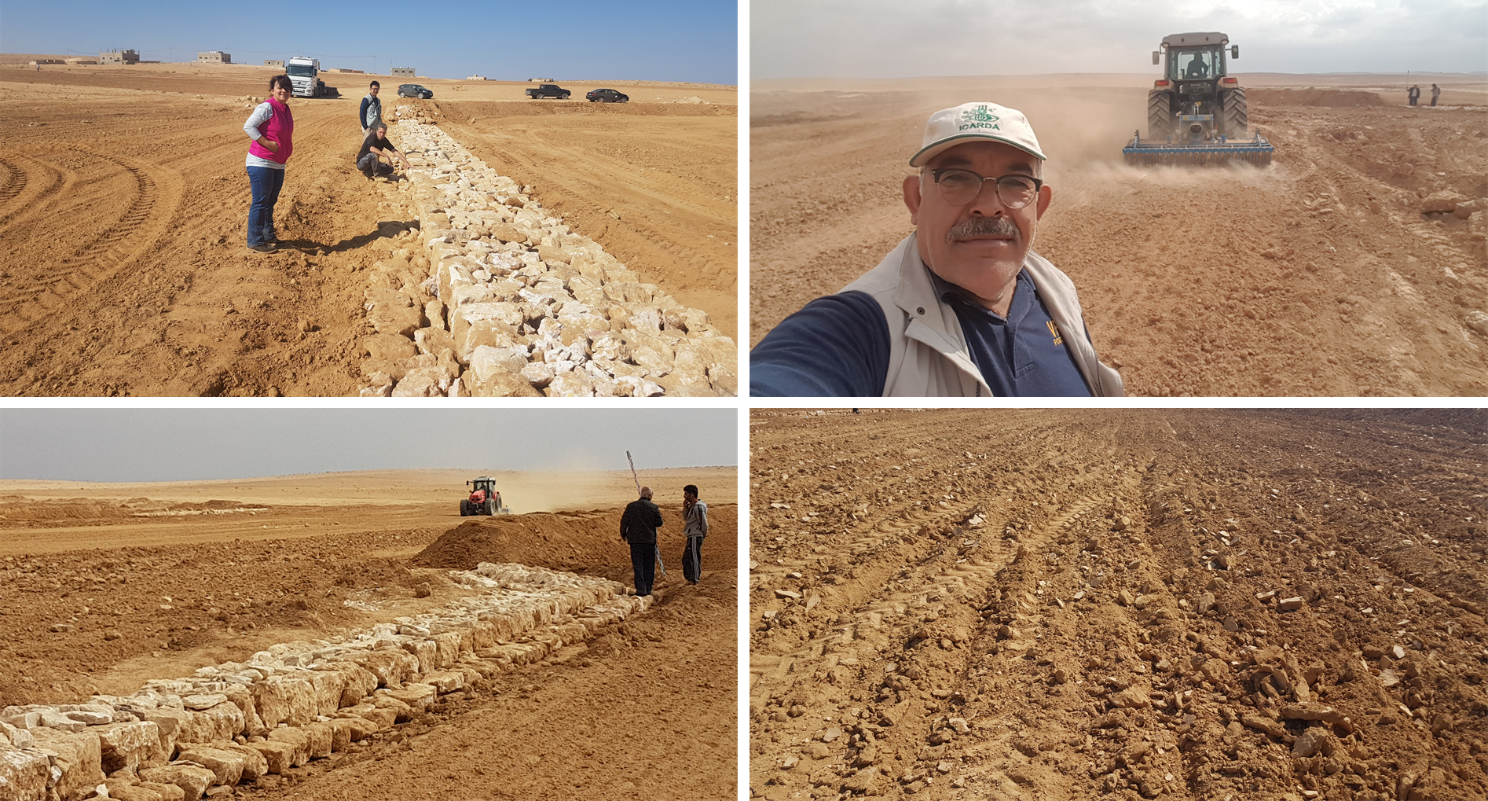
The overall Marab (reshaped flood plain) area is 10 hectares. The natural flood plain was leveled up to the sides; the natural slope in flow direction ranges between 0.1 and 1.5% (D). The later stone bund construction (soil relocation) and siltation/erosion processes over time develop a slight step-terraced bund compartment system, with the single compartments having much smaller slope than the overall Marab. At the sides, the levelled area slightly increases towards the natural terrain (natural terrain at the sides is around 0.1 to 0.3m higher compared with the leveled Marab). This avoids side outflow of water during design storms (*). Bund structures, along the contour, are built with a loader up to around 0.7 to 1.0m height and around 2.0 – 3.0m bottom width. The bunds are built with compaction through the loader. Interspace between the bunds is between 10-50 meters (C), depending on the local slope in the flow direction, having around 0.1 to 0.3m soil surface elevation difference between the bunds. Stone made design-spillways (A) are being constructed around the middle of each bund, with certain position change between the bund in downstream direction. Thus, spillways do not perfectly align with respect to the bund, but create a meandering flow around the center. The stone-protected design-spillways are designed to safely route at least the expected 2-5 year return period flood event. The Marab plain is not perfectly even, especially at the sides, to avoid water flowing around the bunds during design storms. However, the Marab-technology is also designed to cope with more extreme events, a storm of 5-10 return period, without significant damages. Therefore, there are emergency-spillways (**) implemented at the sides of each bund (B). These emergency-spillways allow excess water to flow out sideways rather than flow over the bund which would damage the structures. Note:
Based on above considerations and calculations bund spillway lengths reach 50-60m in the specific watershed.
* A design storm is a rainfall event that results in a flood event as water accumulates throughout the watershed. The Marab is designed to harvest the water optimally by (design) spill ways that keep the water in the Marab. A design storm relates to a certain return period. In general a longer return period (i.e. less frequent) accounts for a more intense event hence a more severe flooding event.
** An emergency spill way is a structure that is designed to discharge excess water coming from storms more extreme than the design storm (i.e. with less frequent storms). In practice this means that the Marab is protected from excess water.
ຜູ້ຂຽນ:
Joren Verbist (Extracted from Google Earth Pro on Jan 7th 2019)
ວັນທີ:
19/12/2020
ຄຸນລັກສະນະ ຂອງເຕັກນິກ (ທີ່ກ່ຽວຂ້ອງ ກັບການແຕ້ມແຜນວາດ ທາງດ້ານເຕັກນີກ):
The cross-section shows the dimensions. Downstream of a bund the width is 70 centimeter. The foundation is 20 centimeter high. The upstream width is 30 centimeter. The total width of the bund varies between 2.2 meter and 2.5 meter.
ຜູ້ຂຽນ:
Stefan Strohmeier
ວັນທີ:
01/07/2020
4.2 ຂໍ້ມູນທົ່ວໄປກ່ຽວກັບການຄິດໄລ່ປັດໃຈຂາເຂົ້າໃນການຜະລິດ ແລະ ມູນຄ່າອື່ນໆ
ລະບຸ ວິທີການ ຄຳໃຊ້ຈ່າຍ ແລະ ປັດໄຈນໍາເຂົ້າ ທີ່ໄດ້ຄິດໄລ່:
- ຕໍ່ພື້ນທີ່ ທີ່ໄດ້ຈັດຕັ້ງປະຕິບັດ ເຕັກໂນໂລຢີ
ໃຫ້ລະບຸຫົວໜ່ວຍ ຂະໜາດ ແລະ ເນື້ອທີ່:
10 ha
ລະບຸ ສະກຸນເງິນທີ່ໃຊ້ສໍາລັບ ການຄິດໄລ່ຄ່າໃຊ້ຈ່າຍ:
- USA
ລະບຸ ຄ່າຈ້າງ ຄ່າແຮງງານສະເລ່ຍ ຕໍ່ ວັນ:
35
4.3 ການສ້າງຕັ້ງກິດຈະກໍາ
| ກິດຈະກໍາ | Timing (season) | |
|---|---|---|
| 1. | Implement upstream watershed rehabilitation measure (e.g. Upstream Vallerani micro water harvesting) | Prior of Marab-Technology construction |
| 2. | Implement gully rehabilitation measure (e.g. Midstream gully rehabilitation) | Prior of Marab-Technology construction |
| 3. | Marab site selection (flood plain): topographic assessment (slope, soil depth, etc.) and consideration of watershed hydrology (e.g. for bund and spillway design) | Before the rainy season |
| 4. | Grading/levelling of natural flood plain incl. gully fill (with soil material) | season (Aug. – Nov.) |
| 5. | Implement bund structures (based on step 4) | season (Aug. – Nov.) |
| 6. | Construct stone made design and emergence spillways (based on step 5) | season (Aug. – Nov.) |
| 7. | Preparation of compartmentalized agricultural fields (bund interspaces) for field crop agriculture | season (Aug. – Nov.) |
ຄວາມຄິດເຫັນ:
The upstream measures as the Vallerani System and gully rehabilitation are strongly recommended but are not taken into account as costs in this documentation. Because this documentation focuses specifically on the Marab-technology.
4.4 ຕົ້ນທຶນ ແລະ ປັດໄຈຂາເຂົ້າທີ່ຈໍາເປັນໃນຈັດຕັ້ງປະຕິບັດ
| ລະບຸ ປັດໃຈ ນໍາເຂົ້າ ໃນການຜະລີດ | ຫົວໜ່ວຍ | ປະລິມານ | ຕົ້ນທຶນ ຕໍ່ຫົວໜ່ວຍ | ຕົ້ນທຶນທັງໝົດ ຂອງປັດໃຈຂາເຂົ້າ ໃນການຜະລິດ | % ຂອງຕົ້ນທຶນທັງໝົດ ທີ່ຜູ້ນໍາໃຊ້ທີ່ດິນ ໃຊ້ຈ່າຍເອງ | |
|---|---|---|---|---|---|---|
| ແຮງງານ | Local Workers | person-days | 50.0 | 35.0 | 1750.0 | |
| ແຮງງານ | Land Survey | person-days | 6.0 | 35.0 | 210.0 | |
| ແຮງງານ | Engineer (+assistance) | person-days | 15.0 | 50.0 | 750.0 | |
| ແຮງງານ | Drivers of heavy machinery | person-days | 12.0 | 35.0 | 420.0 | |
| ອຸປະກອນ | Grader | machine-days | 3.0 | 250.0 | 750.0 | |
| ອຸປະກອນ | Loader | machine-days | 10.0 | 250.0 | 2500.0 | |
| ອຸປະກອນ | Deep Plow | machine-days | 3.0 | 200.0 | 600.0 | |
| ອຸປະກອນ | Tractor (to pull the shallow and deep plow) | machine-days | 5.0 | 200.0 | 1000.0 | |
| ອຸປະກອນ | Shallow Plow | machine-days | 2.0 | 200.0 | 400.0 | |
| ອຸປະກອນ | Water Tank Truck | Tank | 1.0 | 50.0 | 50.0 | |
| ອຸປະກອນ | Small Equipment (Shovel, pickaxe, buckets) | Equipment | 1.0 | 200.0 | 200.0 | |
| ວັດສະດຸກໍ່ສ້າງ | Stones | Kubic Metre | 200.0 | 10.0 | 2000.0 | |
| ອື່ນໆ | Transportation of heavy machinery | 1.0 | 2000.0 | 2000.0 | ||
| ອື່ນໆ | Security | 1.0 | 300.0 | 300.0 | ||
| ຕົ້ນທຶນທັງໝົດ ໃນການຈັດຕັ້ງປະຕິບັດ ເຕັກໂນໂລຢີ | 12930.0 | |||||
| ຄ່າໃຊ້ຈ່າຍທັງໝົດ ສຳລັບການສ້າງຕັ້ງເຕັກໂນໂລຢີ ເປັນສະກຸນເງີນໂດລາ | 12930.0 | |||||
ຖ້າຫາກຜູ້ນຳໃຊ້ທີ່ດິນ ນຳໃຊ້ມູນຄ່າຕ່ຳກວ່າ 100% ໃຫ້ລະບຸ ແມ່ນໃຜເປັນຜູ້ຊ່ວຍ ໃນລາຍຈ່າຍທີ່ເຫຼືອ:
ICARDA and National Agricultural Research Centre (NARC)
ຄວາມຄິດເຫັນ:
These costs are for establishment (so one-time) and are for the total Marab-technology i.e. 10 ha.
4.5 ບໍາລຸງຮັກສາ / ແຜນຈັດຕັ້ງປະຕິບັດ ກິດຈະກໍາ
| ກິດຈະກໍາ | ໄລຍະເວລາ / ຄວາມຖີ່ | |
|---|---|---|
| 1. | Maintaining the structures based on observations and possible damages after the rainy season, so no clear maintenance plans | Before the rainy season (Oct. – Nov.)/upon observation |
ຄວາມຄິດເຫັນ:
Excludes annual farming costs (e.g. seedbed preparation)
4.6 ຄ່າໃຊ້ຈ່າຍ ແລະ ປັດໄຈນໍາເຂົ້າທີ່ຈໍາເປັນສໍາລັບການບໍາລຸງຮັກສາກິດຈະກໍາ / ແຜນປະຕິບັດ (ຕໍ່ປີ)
| ລະບຸ ປັດໃຈ ນໍາເຂົ້າ ໃນການຜະລີດ | ຫົວໜ່ວຍ | ປະລິມານ | ຕົ້ນທຶນ ຕໍ່ຫົວໜ່ວຍ | ຕົ້ນທຶນທັງໝົດ ຂອງປັດໃຈຂາເຂົ້າ ໃນການຜະລິດ | % ຂອງຕົ້ນທຶນທັງໝົດ ທີ່ຜູ້ນໍາໃຊ້ທີ່ດິນ ໃຊ້ຈ່າຍເອງ | |
|---|---|---|---|---|---|---|
| ແຮງງານ | Engineer | person days per year | 2.0 | 50.0 | 100.0 | 100.0 |
| ແຮງງານ | Worker | person days per year | 6.0 | 35.0 | 210.0 | 100.0 |
| ອຸປະກອນ | Loader | machine days per year | 1.0 | 250.0 | 250.0 | 100.0 |
| ວັດສະດຸກໍ່ສ້າງ | Stones | Kubic Metre | 10.0 | 10.0 | 100.0 | 100.0 |
| ຕົ້ນທຶນທັງໝົດ ທີ່ໃຊ້ໃນການບໍາລຸງຮັກສາ ເຕັກໂນໂລຢີ | 660.0 | |||||
| ຄ່າໃຊ້ຈ່າຍທັງໝົດ ສຳລັບການບົວລະບັດຮກສາເຕັກໂນໂລຢີ ເປັນສະກຸນເງີນໂດລາ | 660.0 | |||||
ຄວາມຄິດເຫັນ:
The costs of practicing agriculture (e.g. cost of seeds and fertilizer) are not taken into account, since these costs were also made before the implementation of this technology.
4.7 ປັດໄຈ ທີ່ສໍາຄັນ ທີ່ສົ່ງຜົນກະທົບ ຕໍ່ຄ່າໃຊ້ຈ່າຍ
ໃຫ້ອະທິບາຍ ປັດໃຈ ທີ່ສົ່ງຜົນກະທົບ ຕໍ່ຕົ້ນທຶນ ໃນການຈັດຕັ້ງປະຕິບັດ:
The special and heavy machinery affect the cost significantly, since these were not available in the area. The implementation of the technology is labour intensive, therefore labour costs are significant as well. However, these costs are initially, so these specific costs are almost zero after establishment. In addition, all the maintenance is payed for by the land users. So, only the establishment was payed for by external parties.
5. ສະພາບແວດລ້ອມທໍາມະຊາດ ແລະ ມະນຸດ
5.1 ອາກາດ
ປະລິມານນໍ້າຝົນປະຈໍາປີ
- < 250 ມີລິແມັດ
- 251-500 ມີລິແມັດ
- 501-750 ມີລິແມັດ
- 751-1,000 ມີລິແມັດ
- 1,001-1,500 ມີລິແມັດ
- 1,501-2,000 ມີລິແມັດ
- 2,001-3,000 ມີລິແມັດ
- 3,001-4,000 ມີລິແມັດ
- > 4,000 ມີລິແມັດ
ໃຫ້ລະບຸສະເລ່ຍ ປະລິມານນໍ້າຝົນຕົກປະຈໍາປີ ເປັນມິນລິແມັດ (ຖ້າຫາກຮູ້ຈັກ):
130.00
ຂໍ້ມູນສະເພາະ / ຄວາມເຫັນກ່ຽວກັບ ປະລິມານນໍ້າຝົນ:
In the specific site/dry areas of Jordan rainy season usually ranges from November until April
Queen Alia International Airport long-time avergae annual rainfall is around 150 mm (around 10km west of the site)
At the site a rainfall tipping bucket has been installed in 2016.
ໃຫ້ລະບຸ ຊື່ສະຖານີ ອຸຕຸນິຍົມ ເພື່ອເປັນຂໍ້ມູນອ້າງອີງ:
Queen Alia International Airport
ເຂດສະພາບອາກາດກະສິກໍາ
- ແຫ້ງແລ້ງ
The maximum temperature usually occurres in August.
The average daily maximum temperature is 25.01 °C.
The average daily minimum temperature is 8.5 °C
5.2 ພູມິປະເທດ
ຄ່າສະເລ່ຍ ຄວາມຄ້ອຍຊັນ:
- ພື້ນທີ່ຮາບພຽງ (0-2%)
- ອ່ອນ (3-5 %)
- ປານກາງ (6-10 %)
- ມ້ວນ (11-15 %)
- ເນີນ(16-30%)
- ໍຊັນ (31-60%)
- ຊັນຫຼາຍ (>60%)
ຮູບແບບຂອງດິນ:
- ພູພຽງ / ທົ່ງພຽງ
- ສັນພູ
- ເປີ້ນພູ
- ເນີນພູ
- ຕີນພູ
- ຮ່ອມພູ
ເຂດລະດັບສູງ:
- 0-100 ແມັດ a.s.l.
- 101-500 ແມັດ a.s.l.
- 501-1,000 ແມັດ a.s.l.
- 1,001-1,500 ແມັດ a.s.l.
- 1,501-2,000 ແມັດ a.s.l.
- 2,001-2,500 ແມັດ a.s.l.
- 2,501-3,000 ແມັດ a.s.l.
- 3,001-4,000 ແມັດ a.s.l.
- > 4,000 ແມັດ a.s.l.
ໃຫ້ລະບຸ ເຕັກໂນໂລຢີ ທີ່ໄດ້ຖືກນຳໃຊ້:
- ລັກສະນະສວດ
ຄຳເຫັນ ແລະ ຂໍ້ມູນສະເພາະ ເພີ່ມເຕີມ ກ່ຽວກັບ ພູມີປະເທດ:
The Marab itself is rather concave (depression shape) / natural depression. However, the bund structures are convex, spreading water over the field.
5.3 ດິນ
ຄວາມເລິກ ຂອງດິນສະເລ່ຍ:
- ຕື້ນຫຼາຍ (0-20 ຊັງຕີແມັດ)
- ຕື້ນ (21-50 ຊຕມ)
- ເລີກປານກາງ (51-80 ຊຕມ)
- ເລິກ (81-120 ຊມ)
- ເລິກຫຼາຍ (> 120 cm)
ເນື້ອດິນ (ໜ້າດິນ):
- ປານກາງ (ດິນໜຽວ, ດິນໂຄນ)
- ບາງລະອຽດ / ໜັກ (ໜຽວ)
ເນື້ອດິນ (ເລິກຈາກໜ້າດິນ ລົງໄປຫຼາຍກວ່າ 20 ຊັງຕິແມັດ):
- ປານກາງ (ດິນໜຽວ, ດິນໂຄນ)
ຊັ້ນອິນຊີວັດຖຸ ເທິງໜ້າດິນ:
- ຕໍາ່ (<1 %)
5.4 ມີນໍ້າ ແລະ ຄຸນນະພາບ
ລະດັບ ນໍ້າໃຕ້ດິນ:
> 50 ແມັດ
ການມີນໍ້າ ເທິງໜ້າດິນ:
ທຸກຍາກ / ບໍ່ມີ
ຄຸນນະພາບນໍ້າ (ບໍ່ມີການບໍາບັດ):
ຜິດປົກກະຕິ
ຄຸນນະພາບນ້ຳ ໝາຍເຖີງ:
ນ້ຳໜ້າດິນ
ມີບັນຫາ ກ່ຽວກັບນໍ້າເຄັມບໍ່?
ບໍ່ແມ່ນ
ເກີດມີນໍ້າຖ້ວມ ໃນພື້ນທີ່ບໍ່?
ແມ່ນ
ເປັນປົກກະຕິ:
ເລື້ອຍໆ
5.5 ຊີວະນາໆພັນ
ຄວາມຫຼາກຫຼາຍ ທາງສາຍພັນ:
- ຕໍ່າ
ຄວາມຫຼາກຫຼາຍ ທາງດ້ານ ທີ່ຢູ່ອາໃສ ຂອງສິ່ງທີ່ມີຊີວິດ:
- ຕໍ່າ
5.6 ຄຸນລັກສະນະ ຂອງຜູ້ນໍາໃຊ້ທີ່ດິນ ທີ່ໄດ້ນໍາໃຊ້ເຕັກໂນໂລຢີ
ຢູ່ປະຈຳ ຫຼື ເຄື່ອນຍ້າຍຕະຫຼອດ:
- ແບບເຄີ່ງຂັງ-ເຄີ່ງປ່ອຍ
ລະບົບ ການຕະຫຼາດ ແລະ ຜົນຜະລິດ:
- ປະສົມປົນເປ( ກຸ້ມຕົນເອງ/ເປັນສິນຄ້າ)
ລາຍຮັບ ທີ່ບໍ່ໄດ້ມາຈາກ ການຜະລິດ ກະສິກໍາ:
- ໜ້ອຍກ່ວາ 10 % ຂອງລາຍຮັບທັງໝົດ
ລະດັບຄວາມຮັ່ງມີ:
- ທຸກຍາກ
- ສະເລ່ຍ
ບຸກຄົນ ຫຼື ກຸ່ມ:
- ບຸກຄົນ / ຄົວເຮືອນ
ລະດັບ ການຫັນເປັນກົນຈັກ:
- ເຄື່ອງກົນຈັກ
ເພດ:
- ຜູ້ຊາຍ
ອາຍຸ ຂອງຜູ້ນໍາໃຊ້ທີ່ດິນ:
- ຊາວໜຸ່ມ
- ໄວກາງຄົນ
ໃຫ້ລະບຸ ຄຸນລັກສະນະ ຂອງຜູ້ນໍາໃຊ້ທີ່ດິນ:
The actual land users are often poor Jordanians or Syrian refugees. However, the owners of the livestock are relatively rich. The landowners are responsible for the maintenance of the intervention.
5.7 ເນື້ອທີ່ສະເລ່ຍຂອງດິນ ທີ່ຜູ້ນຳໃຊ້ທີ່ດິນ ໃຊ້ເຮັດເຕັກໂນໂລຢີ
- <0.5 ເຮັກຕາ
- 0.5-1 ເຮັກຕາ
- 1-2 ເຮັກຕາ
- 2-5 ເຮັກຕາ
- 5-15 ເຮັກຕາ
- 15-50 ເຮັກຕາ
- 50-100 ເຮັກຕາ
- 100-500 ເຮັກຕາ
- 500-1,000 ເຮັກຕາ
- 1,000-10,000 ເຮັກຕາ
- > 10,000 ເຮັກຕາ
ຖືໄດ້ວ່າ ເປັນຂະໜາດນ້ອຍ, ກາງ ຫຼື ໃຫຍ່ (ອີງຕາມເງື່ອນໄຂ ສະພາບຄວາມເປັນຈິງ ຂອງທ້ອງຖີ່ນ)? :
- ຂະໜາດກາງ
ຄວາມຄິດເຫັນ:
10ha
5.8 ເຈົ້າຂອງທີ່ດິນ, ສິດໃຊ້ທີ່ດິນ, ແລະ ສິດທິການນໍາໃຊ້ນໍ້າ
ເຈົ້າຂອງດິນ:
- ບຸກຄົນ, ທີ່ມີຕໍາແໜ່ງ
ສິດທິ ໃນການນໍາໃຊ້ທີ່ດິນ:
- ເຊົ່າ
- ບຸກຄົນ
- NA
ສິດນຳໃຊ້ທີ່ດິນ ແມ່ນ ອີງໃສ່ລະບົບກົດໝາຍແບບດັ້ງເດີມບໍ?
ແມ່ນ
5.9 ການເຂົ້າເຖິງການບໍລິການ ແລະ ພື້ນຖານໂຄງລ່າງ
ສຸຂະພາບ:
- ທຸກຍາກ
- ປານກາງ
- ດີ
ການສຶກສາ:
- ທຸກຍາກ
- ປານກາງ
- ດີ
ການຊ່ວຍເຫຼືອ ດ້ານວິຊາການ:
- ທຸກຍາກ
- ປານກາງ
- ດີ
ການຈ້າງງານ (ຕົວຢ່າງ, ການເຮັດກິດຈະກໍາອື່ນ ທີ່ບໍ່ແມ່ນ ການຜະລິດກະສິກໍາ):
- ທຸກຍາກ
- ປານກາງ
- ດີ
ຕະຫຼາດ:
- ທຸກຍາກ
- ປານກາງ
- ດີ
ພະລັງງານ:
- ທຸກຍາກ
- ປານກາງ
- ດີ
ຖະໜົນຫົນທາງ ແລະ ການຂົນສົ່ງ:
- ທຸກຍາກ
- ປານກາງ
- ດີ
ການດື່ມນໍ້າ ແລະ ສຸຂາພິບານ:
- ທຸກຍາກ
- ປານກາງ
- ດີ
ການບໍລິການ ທາງດ້ານການເງິນ:
- ທຸກຍາກ
- ປານກາງ
- ດີ
6. ຜົນກະທົບ ແລະ ລາຍງານສະຫຼຸບ
6.1 ການສະແດງຜົນກະທົບ ພາຍໃນພື້ນທີ່ ທີ່ໄດ້ຈັດຕັ້ງປະຕິບັດ ເຕັກໂນໂລຢີ
ຜົນກະທົບທາງເສດຖະກິດສັງຄົມ
ການຜະລິດ
ການຜະລິດພືດ
ຄວາມຄິດເຫັນ / ລະບຸແຈ້ງ:
The crops produced are used as fodder
ການຜະລິດອາຫານສັດ
ປະລິມານ ກ່ອນການຈັດຕັ້ງປະຕິບັດ ການຄຸ້ມຄອງ ທີ່ດິນແບບຍືນຍົງ:
0.05ton/ha
ປະລີມານ ຫຼັງການຈັດຕັ້ງປະຕິບັດ ການຄຸ້ມຄອງ ທີ່ດິນແບບຍືນຍົງ:
5ton/ha
ຄວາມຄິດເຫັນ / ລະບຸແຈ້ງ:
The production of the fodder is increased as the barley yield is mostly used to feed animals and also the stubble is grazed.
ຄຸນນະພາບຂອງອາຫານສັດ
ຄວາມຄິດເຫັນ / ລະບຸແຈ້ງ:
The barley is fed to the livestock
ເນື້ອທີ່ການຜະລິດ
ຄວາມຄິດເຫັນ / ລະບຸແຈ້ງ:
Due to the bunds (but very limited and inevitable)
ການຈັດການຄຸ້ມຄອງທີ່ດິນ
ລາຍໄດ້ ແລະ ຄ່າໃຊ້ຈ່າຍ
ຄ່າໃຊ້ຈ່າຍ ປັດໄຈນໍາເຂົ້າ ໃນການຜະລິດກະສິກໍາ
ຄວາມຄິດເຫັນ / ລະບຸແຈ້ງ:
Expenses are slightly increased due to possible maintenance of the Marab. However, the increased yield justifies this.
ລາຍຮັບ ຈາກການຜະລີດ
ມີວຽກໜັກ
ຄວາມຄິດເຫັນ / ລະບຸແຈ້ງ:
Due to possible maintenance
ຜົນກະທົບດ້ານວັດທະນາທໍາສັງຄົມ
ການຄໍ້າປະກັນ ສະບຽງອາຫານ / ກຸ້ມຢູ່ກຸ້ມກິນ
ຄວາມຮູ້ກ່ຽວກັບ ການຄຸ້ມຄອງ ທີ່ດິນແບບຍືນຍົງ / ການເຊື່ອມໂຊມຂອງດິນ
ຄວາມຄິດເຫັນ / ລະບຸແຈ້ງ:
During the construction, local community were hired as workers, this has significantly boosted their knowlegde about SLM.
ຜົນກະທົບຕໍ່ລະບົບນິເວດ
ວົງຈອນນໍ້າ / ນໍ້າ
ການຂຸດຄົ້ນ / ການເກັບກັກນໍ້າ
ການໄຫຼ ຂອງນໍ້າໜ້າດິນ
ການລະບາຍນໍ້າ
ຊັ້ນນໍ້າໄຕ້ດິນ / ນໍ້າ
ດິນ
ຄວາມຊຸ່ມຂອງດິນ
ການປົກຄຸມຂອງດິນ
ການສູນເສຍດິນ
ການທັບຖົມຂອງດິນ
ດິນເປັນຜົງ / ການຈັບໂຕຂອງດິນ ທີ່ມີຂະໜາດນ້ອຍຫຼາຍ ທີ່ມີການຈັບໂຕກັນເປັນກ້ອນ
ອິນຊີວັດຖຸໃນດິນ / ຢູ່ລຸ່ມຊັ້ນດິນ C
ຊີວະນານາພັນ: ສັດ, ພືດ
ການປົກຫຸ້ມຂອງພືດ
ມວນຊີວະພາບ / ຢູ່ເທິງຊັ້ນດິນ C
ການຫຼຸດຜ່ອນ ຄວາມສ່ຽງ ຈາກໄພພິບັດ ແລະ ອາກາດປ່ຽນແປງ
ຜົນກະທົບ ຂອງນໍ້າຖ້ວມ
ຜົນກະທົບ ຂອງໄພແຫ້ງແລ້ງ
6.2 ຜົນກະທົບທາງອ້ອມ ຈາກການນໍາໃຊ້ເຕັກໂນໂລຢີ
ນໍ້າຖ້ວມຢູ່ເຂດລຸ່ມນໍ້າ
ຄວາມຄິດເຫັນ / ລະບຸແຈ້ງ:
Reduced downstream flooding is desired
ການທັບຖົມ ຂອງດິນຕະກອນ ຢູ່ເຂດລຸ່ມນໍ້າ
ຄວາມຄິດເຫັນ / ລະບຸແຈ້ງ:
Reduced downstream siltation is desired
6.3 ການປ້ອງກັນ ແລະ ຄວາມບອບບາງ ຂອງເຕັກໂນໂລຢິ ໃນການປ່ຽນແປງສະພາບດິນຟ້າອາກາດ ແລະ ກ່ຽວຂ້ອງກັບອາກາດທີ່ມີການປ່ຽນແປງທີ່ຮຸນແຮງ / ໄພພິບັດທາງທໍາມະຊາດ (ຮັບຮູ້ໄດ້ໂດຍຜູ້ນໍາໃຊ້ທີ່ດິນ)
ການປ່ຽນແປງດິນຟ້າອາກາດ ເທື່ອລະກ້າວ
ການປ່ຽນແປງດິນຟ້າອາກາດ ເທື່ອລະກ້າວ
| ລະດູການ | ເພີ່ມຂື້ນ ຫຼື ຫຼຸດລົງ | ການນໍາໃຊ້ ເຕັກໂນໂລຢີ ສາມາດ ຮັບມື ໄດ້ຄືແນວໃດ? | |
|---|---|---|---|
| ປະລິມານນໍ້າຝົນປະຈໍາປີ | ຫຼຸດລົງ | ດີ |
ອາກາດ ທີ່ກ່ຽວພັນກັບຄວາມຮຸນແຮງ (ໄພພິບັດທາງທໍາມະຊາດ)
ໄພພິບັດທາງອຸຕຸນິຍົມ
| ການນໍາໃຊ້ ເຕັກໂນໂລຢີ ສາມາດ ຮັບມື ໄດ້ຄືແນວໃດ? | |
|---|---|
| ພະຍຸຝົນ | ດີຫຼາຍ |
ໄພພິບັດທາງອຸທົກກະສາກ
| ການນໍາໃຊ້ ເຕັກໂນໂລຢີ ສາມາດ ຮັບມື ໄດ້ຄືແນວໃດ? | |
|---|---|
| ນໍ້າຖ້ວມຮູນແຮງ | ດີຫຼາຍ |
6.4 ການວິເຄາະຕົ້ນທຶນ ແລະ ຜົນປະໂຫຍດ
ຈະເຮັດປະໂຫຍດເພື່ອປຽບທຽບກັບຄ່າໃຊ້ຈ່າຍກັບສິ່ງກໍ່ສ້າງ (ຈາກທັດສະນະຂອງຜູ້ນຳໃຊ້ທີ່ດິນ) ໄດ້ແນວໃດ?
ຜົນຕອບແທນ ໃນໄລຍະສັ້ນ:
ຜົນກະທົບທາງລົບເລັກນ້ອຍ
ຜົນຕອບແທນ ໃນໄລຍະຍາວ:
ຜົນກະທົບທາງບວກ
ຈະໄດ້ຮັບຜົນປະໂຫຍດເມື່ອປຽບທຽບກັບ / ຄ່າໃຊ້ຈ່າຍໃນການບຳລຸງຮັກສາທີເ່ກີດຂື້ນອິກ (ຈາກທັດສະນະຄະຕິຂອງຜູ້ນຳໃຊ້ທີ່ດິນ) ໄດ້ແນວໃດ?
ຜົນຕອບແທນ ໃນໄລຍະສັ້ນ:
ຜົນກະທົບທາງບວກ
ຜົນຕອບແທນ ໃນໄລຍະຍາວ:
ຜົນກະທົບທາງບວກຫຼາຍ
ຄວາມຄິດເຫັນ:
The initial investment is quite large. Therefore, the short term returns is classified as slightly negative. After some seasons with good (stable) crop yield the return of investment is positive. Long term benefits are classified positively.
6.5 ການປັບຕົວຮັບເອົາເຕັກໂນໂລຢີ
- 1-10%
ຖ້າຫາກວ່າມີ, ປະລິມານ (ຈໍານວນຂອງຄົວເຮືອນ / ເນື້ອທີ່ການຄຸ້ມຄອງ):
These are some farmers that live near the Marab. They try to copy the Marab in their fields.
ທັງໝົດນັ້ນ ແມ່ນໃຜ ໄດ້ປັບຕົວເຂົ້າ ໃນການນໍາໃຊ້ ເຕັກໂນໂລຢີ, ມີຈັກຄົນ ທີ່ສາມາດເຮັດເອງໄດ້, ຕົວຢ່າງ, ປາດສະຈາກ ການຊ່ວຍເຫຼືອ ທາງດ້ານອຸປະກອນ / ການຈ່າຍເປັນເງິນ?
- 91-100%
ຄວາມຄິດເຫັນ:
The local farmers like the technology and acknowledge its positive impacts. They would like to have a Marab themselves (even if their locally owned lands are not suitable in many cases). Local agro-pastoralists copy and apply parts of the technology (especially the bund
system). However, it strongly recommended that implementing a Marab-technology is done as a community-based project/intervention; the Marab technology should be part of an integrated watershed management plan, located at the most suitable location for the entire community.
6.6 ການປັບຕົວ
ໄດ້ມີການດັດປັບ ເຕັກໂນໂລຢີ ເພື່ອໃຫ້ແທດເໝາະກັບເງື່ອນໄຂ ການປ່ຽນແປງບໍ?
ແມ່ນ
ຖ້າແມ່ນ, ລະບຸແມ່ນເງື່ອນໄຂ ໃດທີ່ໄດ້ປ່ຽນແປງ ທີ່ເຮັດໃຫ້ເກີດມີການປັບຕົວ:
- ການປ່ຽນແປງດິນຟ້າອາກາດ / ຮ້າຍແຮງ
ລະບຸການຮັບຮອງເອົາ ເຕັກໂນໂລຢີ (ການອອກແບບ, ອຸປະກອນການ / ຊະນິດພັນ ແລະ ອື່ນໆ):
The spillway design can be adapted to variable surface runoff occurrence (affected by climate change).
6.7 ຈຸດແຂງ / ຂໍ້ດີ / ໂອກາດ ໃນການນໍາໃຊ້ ເຕັກໂນໂລຢີ
| ຈຸດແຂງ / ຂໍ້ດີ / ໂອກາດໃນການນໍາໃຊ້ທີ່ດິນ |
|---|
| The farmers highly appreciate the improved economic situation as consequence of the increased yield. |
| A strength of the Marab technology is that water is harvested and minimally spilled away, preventing top-soil erosion and accumulating soil organic matter consequently preserving soil fertility. |
| The crop produces grains: can be (partially) used for re-seeding in the coming seasons; economic gain + increase resilience. |
| ຈຸດແຂງ / ຈຸດດີ / ໂອກາດ ຈາກທັດສະນະຂອງຜູ້ປ້ອນຂໍ້ມູນ ຫຼື ບຸກຄົນສຳຄັນ |
|---|
| Economic improvement through targeted agricultural interventions in the most suitable location(s) of a watershed. This aims at decreasing the pressure on the fragile dry land ecosystem. The locally increased yield raises awareness on non-sufficient field crop agriculture in uplands (commonly achieved) and might increase the willingness for more nature-based sustainable land management measures in the less fertile and runoff generating (more vulnerable uplands) parts of the watershed. Therefore, the Marab technology could be a starting point for a watershed rehabilitation initiative. |
| The Marab technology creates an opportunity for multiple crop introduction (due to natural flood irrigation) – aside from barley monoculture (agro-diversity). |
| Increased water infiltration conserves water and might lead to deep percolation (groundwater recharge). |
6.8 ຈຸດອ່ອນ / ຂໍ້ເສຍ / ຄວາມສ່ຽງ ໃນການນໍາໃຊ້ ເຕັກໂນໂລຢີ ແລະ ວິທີການແກ້ໄຂບັນຫາ
| ຈຸດອ່ອນ / ຂໍ້ເສຍ / ຄວາມສ່ຽງໃນມຸມມອງຂອງຜູ້ນໍາໃຊ້ທີ່ດິນ | ມີວິທີການແກ້ໄຂຄືແນວໃດ? |
|---|---|
| The Marab depends on upstream water users; can lead to increased tensions | Agreement among the community - conducting contacts/contracts among upstream and downstream farmers. Joint watershed management and benefit share could be mediate these tension. And might even lead to watershed rehabilitation. |
| High initial investment and partially high maintenance costs (including machinery) | Once the implementation is linked with larger environmental benefits – communities might receive funds from the government or international donors. |
| Loss of cultivation area where the bunds are placed | Unavoidable. However, the gain of interspaces exceeds these losses several times. |
| ຈຸດອ່ອນ/ຂໍ້ບົກຜ່ອງ/ຄວາມສ່ຽງ ຈາກທັດສະນະຂອງຜູ້ປ້ອນຂໍ້ມູນ ຫຼື ບຸກຄົນສຳຄັນ | ມີວິທີການແກ້ໄຂຄືແນວໃດ? |
|---|---|
| Tensions among multiple actors in the watershed (selection of Marab area) | Develop institutions that could avoid these tensions by establishing agreements, contracts, rules, or regulations. |
| Heavy machinery in a vulnerable ecosystems – can induce other requests/use by locals (improper use) | Targeted policies in place & enforcements |
| Increasing wealth inequality between farmers and/or communities. | Creation of institutions, which assure fair distribution. This would benefit the whole watershed. |
7. ເອກະສານອ້າງອີງ ແລະ ການເຊື່ອມຕໍ່
7.1 ວິທີການ / ແຫຼ່ງຂໍ້ມູນ
- ການໄປຢ້ຽມຢາມພາກສະໜາມ, ການສໍາຫຼວດພາກສະໜາມ
- ການສໍາພາດ ຜູ້ນໍາໃຊ້ທີ່ດິນ
- ສໍາພາດ ຊ່ຽວຊານ ການຄຸ້ມຄອງ ດິນແບບຍືນຍົງ
- ການລວບລວມ ບົດລາຍງານ ແລະ ເອກະສານ ອື່ນໆ ທີ່ມີຢູ່ແລ້ວ
ເມື່ອໃດທີ່ໄດ້ສັງລວມຂໍ້ມູນ (ຢູ່ພາກສະໜາມ)?
15/04/2020
7.2 ເອກກະສານອ້າງອີງທີ່ເປັນບົດລາຍງານ
ຫົວຂໍ້, ຜູ້ຂຽນ, ປີ, ISBN:
Strohmeier, S. (2017). Dimensioning of Marab in Majidyya.
ຫົວຂໍ້, ຜູ້ຂຽນ, ປີ, ISBN:
Strohmeier, S. (2017). Watershed Restoration in Baia Areas of Jordan Technology Packages for Controlling and Monitoring Gully Erosion.
ມີຢູ່ໃສ?ມູນຄ່າເທົ່າໃດ?
https://mel.cgiar.org/projects/jordan-watershed-restoration-project
ຫົວຂໍ້, ຜູ້ຂຽນ, ປີ, ISBN:
Mira Haddad, Stefan Strohmeier. (12/12/2017). Treated upland areas map. Jordan: International Center for Agricultural Research in the Dry Areas (ICARDA).
ມີຢູ່ໃສ?ມູນຄ່າເທົ່າໃດ?
https://hdl.handle.net/20.500.11766/9108
ຫົວຂໍ້, ຜູ້ຂຽນ, ປີ, ISBN:
Stefan Strohmeier, Mira Haddad, Ismail Shukri. (8/11/2018). Marab - water harvesting based agriculture.
ມີຢູ່ໃສ?ມູນຄ່າເທົ່າໃດ?
https://hdl.handle.net/20.500.11766/9069
ຫົວຂໍ້, ຜູ້ຂຽນ, ປີ, ISBN:
Boubaker Dhehibi, Mira Haddad, Stefan Strohmeier, Masnat El-Hiary. (24/7/2020). Enhancing a Traditional Water Harvesting Technique in Jordan’s Agro-pastoral Farming System. Lebanon: International Center for Agricultural Research in the Dry Areas (ICARDA).
ມີຢູ່ໃສ?ມູນຄ່າເທົ່າໃດ?
https://hdl.handle.net/20.500.11766/11506
7.3 ເຊື່ອມຕໍ່ກັບຂໍ້ມູນທີ່ກ່ຽວຂ້ອງໂດຍກົງ
ຫົວຂໍ້ / ພັນລະນາ:
WATER HARVESTING FOR RESTORING RANGELANDS IN JORDAN
URL:
https://www.icarda.org/media/drywire/water-harvesting-restoring-rangelands-jordan
ຂໍ້ມູນການເຊື່ອມຕໍ່ ແລະ ເນື້ອໃນ
ຂະຫຍາຍທັງໝົດ ຍຸບທັງໝົດການເຊື່ອມຕໍ່
ບໍ່ມີຂໍ້ມູນການເຊື່ອມຕໍ່
ເນື້ອໃນ
ບໍ່ມີເນື້ອໃນ