Stone lines [Ouganda]
- Création :
- Mise à jour :
- Compilateur : Wilson Bamwerinde
- Rédacteur : –
- Examinateurs : Fabian Ottiger, Alexandra Gavilano
Ennyiriri z'amayinja eziziyiza ettaka okutwalibwa enkuba (Luganda)
technologies_1589 - Ouganda
Voir les sections
Développer tout Réduire tout1. Informations générales
1.2 Coordonnées des personnes-ressources et des institutions impliquées dans l'évaluation et la documentation de la Technologie
Spécialiste GDT:
Spécialiste GDT:
Nom du projet qui a facilité la documentation/ l'évaluation de la Technologie (si pertinent)
The Transboundary Agro-ecosystem Management Project for the Kagera River Basin (GEF-FAO / Kagera TAMP )Nom du ou des institutions qui ont facilité la documentation/ l'évaluation de la Technologie (si pertinent)
Food and Agriculture Organization of the United Nations (FAO) - Italie1.3 Conditions relatives à l'utilisation par WOCAT des données documentées
Le compilateur et la(les) personne(s) ressource(s) acceptent les conditions relatives à l'utilisation par WOCAT des données documentées:
Oui
1.5 Référence au(x) Questionnaires sur les Approches de GDT (documentées au moyen de WOCAT)

FFS/SLM Community Initiative [Ouganda]
Farmers are organized to promote adoption of sustainable land management best practices within the community
- Compilateur : Wilson Bamwerinde
2. Description de la Technologie de GDT
2.1 Courte description de la Technologie
Définition de la Technologie:
Stone lines are built along a contour to control soil erosion on a degraded steep slope.
2.2 Description détaillée de la Technologie
Description:
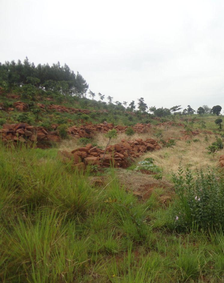
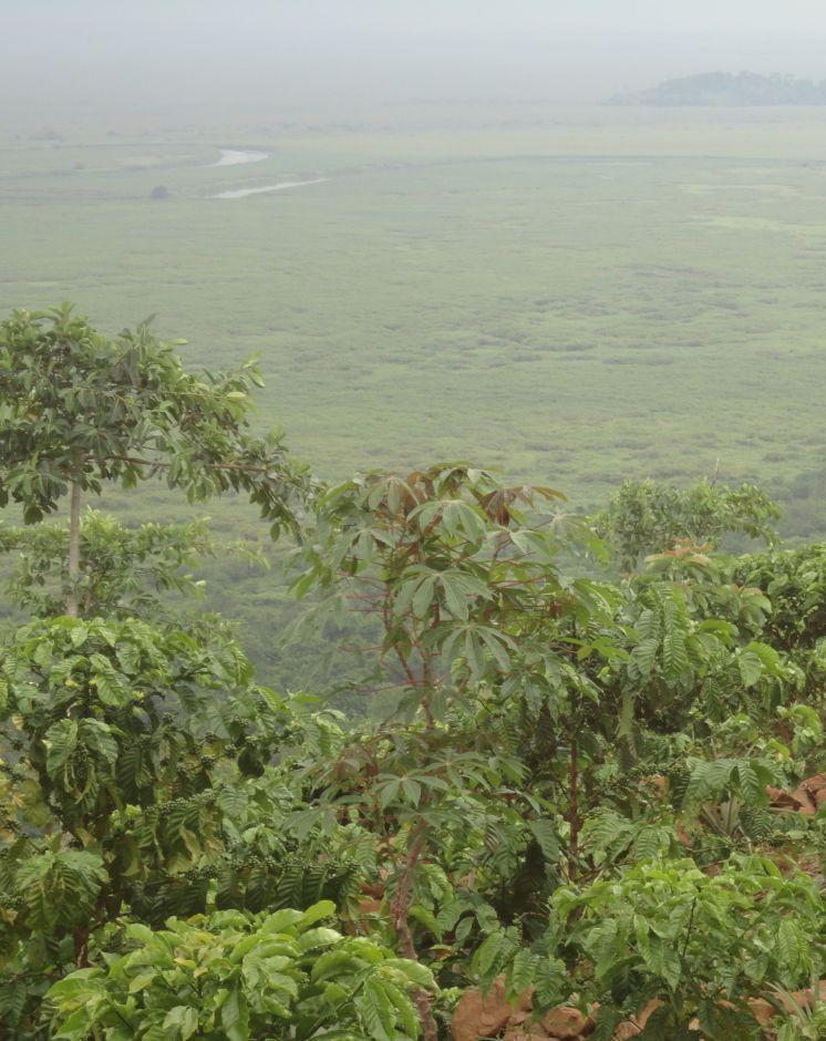
Most of the traditional cropland in Rakai District is fairly flat. However, there are many hectares of very steep, stony, wind-swept slopes facing the Kagera River Valley and Lake Victoria. These slopes have been degraded for a long time because when it rains the runoff is very fast and carries away soil and crops. The swampy Kagera river flood plains below the slopes are fertile because of the deposits of top soil carried from the slopes. Over the last 3 years, farmers have changed from the traditional farming practice where cultivation was done with little or no protection of soil and water movement on the steep slopes to using stone lines along a contour. The stone lines are arranged along the contour to act as a barrier that slows down the speed of water and soil, improve infiltration, mitigate land slides and trap sediment thereby reducing the extent of erosion.
Purpose of the Technology: The technical objective of stone lines is to minimize water and soil movement down the slope and, over time, enable the building of a terrace from the accumulation of soil on the upper side of the barrier.
Establishment / maintenance activities and inputs: The stones are arranged along the contour, guided by a rope. The contour is determined using an A-Frame. The other tools required to establish stone lines are hand hoes, pick axes, and pangas. Establishment requires a lot of labor by which the following activities are accomplished: (i) stones exposed by decades of runoff on hillsides are dug up, collected and placed along contours in a field 200 m by 300 m. The width of each stone line is 0.4 m to 0.6 m and 0.5 m high. The length is dependent on the size of the field across the slope. The spacing from one line to another is 8 m to 12 m, depending on the steepness of the slope. (ii) The exposed sandy loam top soil is very dry and dusty even in the rainy season. Digging with hand hoes loosens the soil. (iii) Following the contour, circular pits of 0.45 m diameter and 0.3 m depth are dug 1.50 m apart, in the middle of every 2 stone lines. In these holes, robusta coffee seedlings are planted. (iv) Beans may be planted throughout the field as a cover crop. The farmer field school (FFS) approach is used because many farmers participate together in completing the establishment tasks. The stone lines are maintained by ensuring that stones which move off the main line are put back and the weeds which grow among the stones are removed to avoid competition with the main crops.
Natural / human environment: There is no known threat to stone lines once they have been established. The runoff cannot gather enough speed between the lines to sweep the stones away because of the short distance. The main offsite benefit is that sediment deposits and water runoff do not destroy crops in the valley below and the Kagera River is protected from silting.
2.3 Photos de la Technologie
Galerie Médias
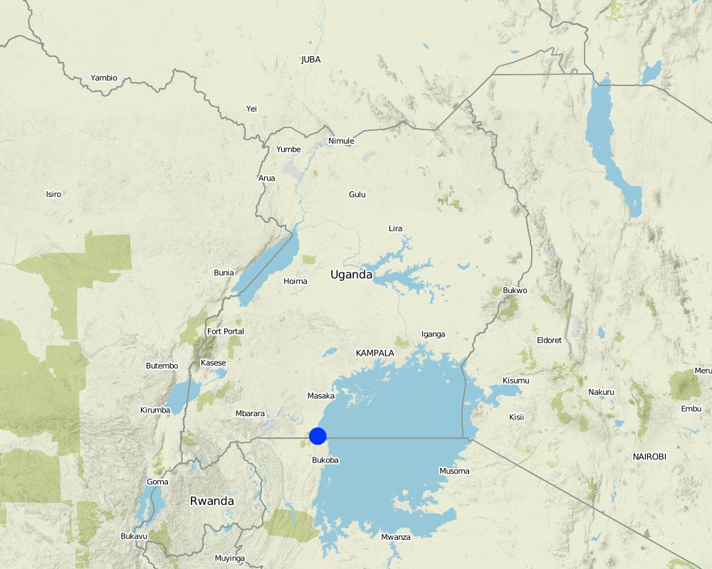
2.5 Pays/ région/ lieux où la Technologie a été appliquée et qui sont couverts par cette évaluation
Pays:
Ouganda
Région/ Etat/ Province:
Uganda
Autres spécifications du lieu:
Rakai District
Commentaires:
Boundary points of the Technology area: -0.96681 31.69066; -0.96706 31.69111; -0.96717 31.69033; -0.96757 31.69038; -0.96774 31.69073
Total area covered by the SLM Technology is 0.06 km2.
Currently about 3 ha but the area is still being expanded by the farmers.
Map
×2.6 Date de mise en œuvre de la Technologie
Si l'année précise est inconnue, indiquez la date approximative: :
- il y a moins de 10 ans (récemment)
2.7 Introduction de la Technologie
Spécifiez comment la Technologie a été introduite: :
- par le biais de projets/ d'interventions extérieures
Commentaires (type de projet, etc.) :
Introduced and supported by Kagera TAMP as an SLM technology
3. Classification de la Technologie de GDT
3.1 Principal(aux) objectif(s) de la Technologie
- réduire, prévenir, restaurer les terres dégradées
3.2 Type(s) actuel(s) d'utilisation des terres, là où la Technologie est appliquée

Terres cultivées
- Cultures annuelles
- Cultures pérennes (non ligneuses)
- Plantations d’arbres ou de buissons
Cultures annuelles - Précisez les cultures:
- céréales - maïs
- légumineuses et légumes secs - fèves
- plantes à racines et à tubercules - pommes de terre
Cultures pérennes (non ligneuses) - Précisez les cultures:
- bananier/plantain/abaca
Plantations d'arbres et d'arbustes - Précisez les cultures:
- café, cultivé en plein champ
Nombre de période de croissance par an: :
- 2
Précisez:
Longest growing period in days: 150 Longest growing period from month to month: February to June Second longest growing period in days: 120 Second longest growing period from month to month: September to November
Commentaires:
Major land use problems (compiler’s opinion): Surface soil erosion is rampant, carrying away all the top soil with valuable nutrients towards to the marshes below.
Major land use problems (land users’ perception): The land is infertile and no crops can grow in that area.
3.5 Groupe de GDT auquel appartient la Technologie
- mesures en travers de la pente
3.6 Mesures de GDT constituant la Technologie

structures physiques
- S6: Murs, barrières, palissades, clôtures
Commentaires:
Main measures: structural measures
3.7 Principaux types de dégradation des terres traités par la Technologie

érosion hydrique des sols
- Wt: perte de la couche superficielle des sols (couche arable)/ érosion de surface
- Wo: effets hors-site de la dégradation
Commentaires:
Main type of degradation addressed: Wt: loss of topsoil / surface erosion
Secondary types of degradation addressed: Wo: offsite degradation effects
Main causes of degradation: deforestation / removal of natural vegetation (incl. forest fires) (Deforestation for fuel wood and agricultural land), education, access to knowledge and support services (inadequate agricultural extension services)
3.8 Prévention, réduction de la dégradation ou réhabilitation des terres dégradées
Spécifiez l'objectif de la Technologie au regard de la dégradation des terres:
- réduire la dégradation des terres
- restaurer/ réhabiliter des terres sévèrement dégradées
Commentaires:
Main goals: mitigation / reduction of land degradation
Secondary goals: rehabilitation / reclamation of denuded land
4. Spécifications techniques, activités, intrants et coûts de mise en œuvre
4.1 Dessin technique de la Technologie
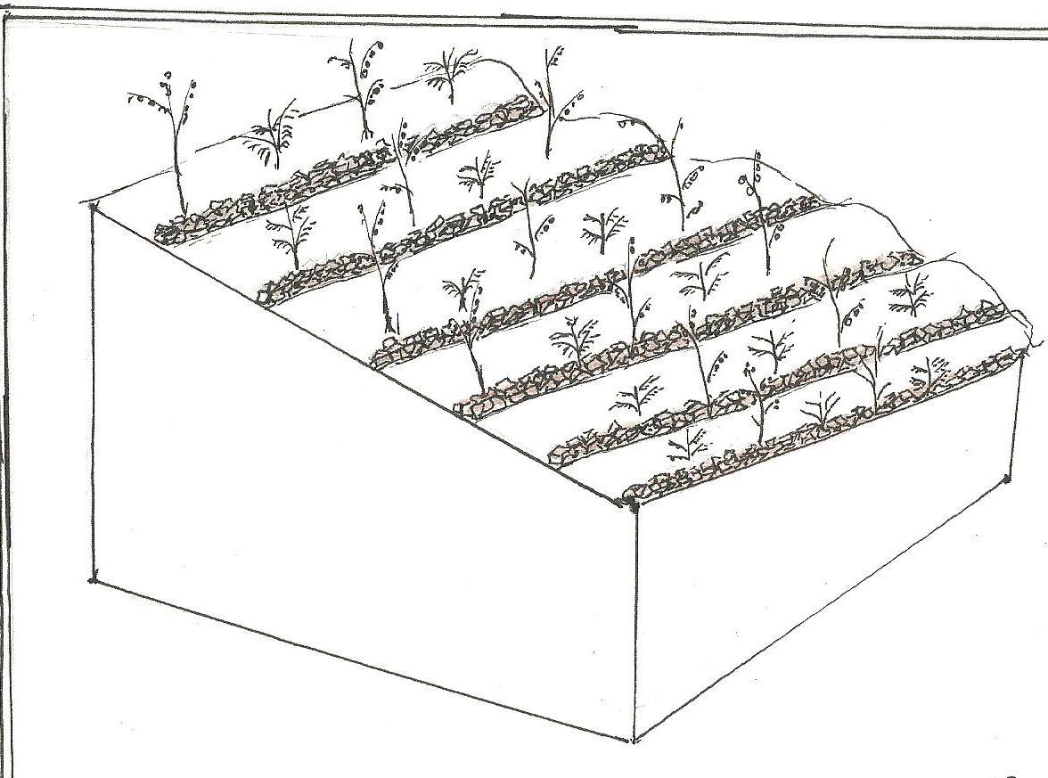
Spécifications techniques (associées au dessin technique):
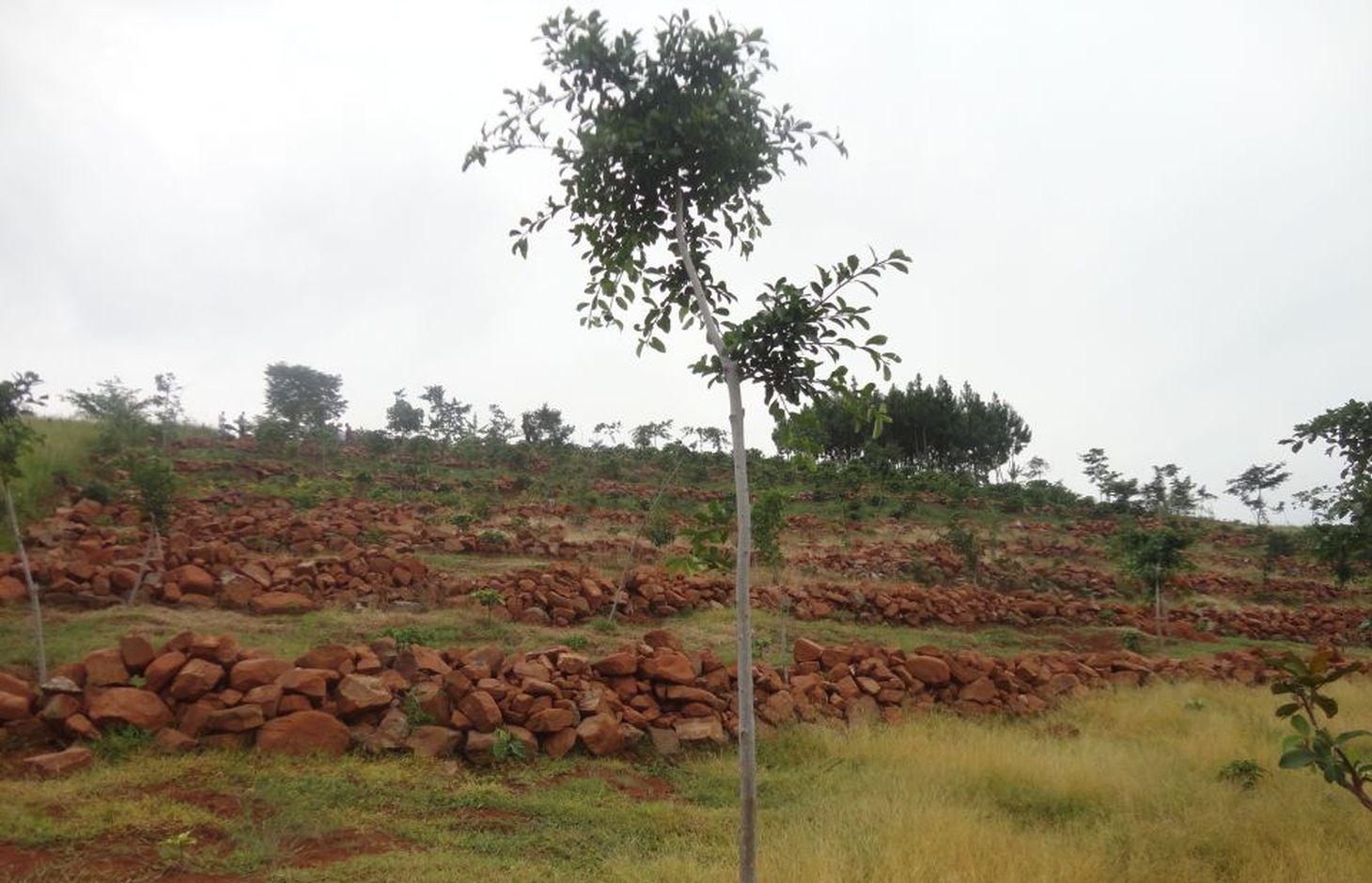
Stone lines on a steep slope. In between is a young coffee plantation.
Location: Katongero. Rakai District
Date: 5-DEC-2013
Technical knowledge required for field staff / advisors: moderate (Technical skill required is keeping the line on the contour)
Technical knowledge required for land users: low (No prior knowledge required)
Main technical functions: control of dispersed runoff: impede / retard, increase of infiltration, sediment retention / trapping, sediment harvesting
Secondary technical functions: reduction of slope length, water harvesting / increase water supply
Wall/ barrier
Vertical interval between structures (m): 3
Spacing between structures (m): n/a
Depth of ditches/pits/dams (m): n/a
Width of ditches/pits/dams (m): n/a
Length of ditches/pits/dams (m): n/a
Height of bunds/banks/others (m): 0.3
Width of bunds/banks/others (m): 0.3
Length of bunds/banks/others (m): 300
Construction material (stone): Big and small stones piled to 0.3 m high, 300 m along a contour
Slope (which determines the spacing indicated above): 38-45%
Lateral gradient along the structure: < 1%
Auteur:
Byonabye Proscovia, Kagera TAMP, Kabale
4.2 Informations générales sur le calcul des intrants et des coûts
autre/ monnaie nationale (précisez):
UGX
Indiquez le taux de change des USD en devise locale, le cas échéant (p.ex. 1 USD = 79.9 réal brésilien): 1 USD = :
2500,0
Indiquez le coût salarial moyen de la main d'œuvre par jour:
10000.00
4.3 Activités de mise en place/ d'établissement
| Activité | Calendrier des activités (saisonnier) | |
|---|---|---|
| 1. | Collection and laying of stones | Dry season |
4.4 Coûts et intrants nécessaires à la mise en place
| Spécifiez les intrants | Unité | Quantité | Coûts par unité | Coût total par intrant | % des coût supporté par les exploitants des terres | |
|---|---|---|---|---|---|---|
| Main d'œuvre | Labour | ha | 1,0 | 1200,0 | 1200,0 | 100,0 |
| Equipements | Tools | ha | 1,0 | 60,0 | 60,0 | 100,0 |
| Coût total de mise en place de la Technologie | 1260,0 | |||||
| Coût total de mise en place de la Technologie en dollars américains (USD) | 0,5 | |||||
Commentaires:
Duration of establishment phase: 12 month(s)
4.5 Activités d'entretien/ récurrentes
| Activité | Calendrier/ fréquence | |
|---|---|---|
| 1. | Repair of lines | wet season |
4.6 Coûts et intrants nécessaires aux activités d'entretien/ récurrentes (par an)
| Spécifiez les intrants | Unité | Quantité | Coûts par unité | Coût total par intrant | % des coût supporté par les exploitants des terres | |
|---|---|---|---|---|---|---|
| Main d'œuvre | Labour | ha | 1,0 | 120,0 | 120,0 | 100,0 |
| Coût total d'entretien de la Technologie | 120,0 | |||||
| Coût total d'entretien de la Technologie en dollars américains (USD) | 0,05 | |||||
Commentaires:
Machinery/ tools: n/a
The calculations reflect costs of establishing the technology on a steep slope (38% to 45%) in December of 2013.
4.7 Facteurs les plus importants affectant les coûts
Décrivez les facteurs les plus importants affectant les coûts :
Labor is the factor that influences costs. Digging up and carrying stones up and across slopes is a labor intensive activity.
5. Environnement naturel et humain
5.1 Climat
Précipitations annuelles
- < 250 mm
- 251-500 mm
- 501-750 mm
- 751-1000 mm
- 1001-1500 mm
- 1501-2000 mm
- 2001-3000 mm
- 3001-4000 mm
- > 4000 mm
Spécifications/ commentaires sur les précipitations:
1501-2000 mm (Ranked 1, 1950 mm)
1001-1500 mm (Ranked 2, To a limited extend)
Zone agro-climatique
- humide
Thermal climate class: tropics. LGP >270 days
5.2 Topographie
Pentes moyennes:
- plat (0-2 %)
- faible (3-5%)
- modéré (6-10%)
- onduleux (11-15%)
- vallonné (16-30%)
- raide (31-60%)
- très raide (>60%)
Reliefs:
- plateaux/ plaines
- crêtes
- flancs/ pentes de montagne
- flancs/ pentes de colline
- piémonts/ glacis (bas de pente)
- fonds de vallée/bas-fonds
Zones altitudinales:
- 0-100 m
- 101-500 m
- 501-1000 m
- 1001-1500 m
- 1501-2000 m
- 2001-2500 m
- 2501-3000 m
- 3001-4000 m
- > 4000 m
Indiquez si la Technologie est spécifiquement appliquée dans des:
- situations concaves
Commentaires et précisions supplémentaires sur la topographie:
Altitudinal zone: 1001-1500 m a.s.l. (1270 m to 1300 m a.s.l.)
Slopes on average: Steep (ranked 1, the slopes of Rakai district where the technology is applied are steep) and moderate (ranked 2, to a limited extent, towards the top of the hill)
5.3 Sols
Profondeur moyenne du sol:
- très superficiel (0-20 cm)
- superficiel (21-50 cm)
- modérément profond (51-80 cm)
- profond (81-120 cm)
- très profond (>120 cm)
Texture du sol (de la couche arable):
- moyen (limoneux)
Matière organique de la couche arable:
- faible (<1%)
Si disponible, joignez une description complète du sol ou précisez les informations disponibles, par ex., type de sol, pH/ acidité du sol, capacité d'échange cationique, azote, salinité, etc.
Soil fertility: Medium
Soil drainage/infiltration: Good
Soil water storage capacity: Low
5.4 Disponibilité et qualité de l'eau
Profondeur estimée de l’eau dans le sol:
> 50 m
Disponibilité de l’eau de surface:
moyenne
Qualité de l’eau (non traitée):
faiblement potable (traitement nécessaire)
5.5 Biodiversité
Diversité des espèces:
- faible
5.6 Caractéristiques des exploitants des terres appliquant la Technologie
Orientation du système de production:
- subsistance (auto-approvisionnement)
Revenus hors exploitation:
- moins de 10% de tous les revenus
Niveau relatif de richesse:
- moyen
Individus ou groupes:
- individu/ ménage
Niveau de mécanisation:
- travail manuel
Genre:
- femmes
- hommes
Indiquez toute autre caractéristique pertinente des exploitants des terres:
Land users applying the Technology are mainly common / average land users
Difference in the involvement of women and men: Men and women work together
Population density: 50-100 persons/km2
Annual population growth: 2% - 3%
and own 20% of the land.
and own 20% of the land.
70% of the land users are average wealthy and own 50% of the land (All land users currently applying the technology are average users).
and own 10% of the land.
Off-farm income specification: Farming is mostly subsistence
Level of mechanization: Manual work (no other form is used in the area)
Market orientation: Subsistence (mostly)
5.7 Superficie moyenne des terres utilisées par les exploitants des terres appliquant la Technologie
- < 0,5 ha
- 0,5-1 ha
- 1-2 ha
- 2-5 ha
- 5-15 ha
- 15-50 ha
- 50-100 ha
- 100-500 ha
- 500-1 000 ha
- 1 000-10 000 ha
- > 10 000 ha
Cette superficie est-elle considérée comme de petite, moyenne ou grande dimension (en se référant au contexte local)?
- petite dimension
Commentaires:
Average area of land owned or leased by land users applying the Technology: Also 1-2 ha and 5-15 ha (both ranked 2)
5.8 Propriété foncière, droits d’utilisation des terres et de l'eau
Propriété foncière:
- individu, sans titre de propriété
Droits d’utilisation des terres:
- individuel
Droits d’utilisation de l’eau:
- accès libre (non organisé)
5.9 Accès aux services et aux infrastructures
santé:
- pauvre
- modéré
- bonne
éducation:
- pauvre
- modéré
- bonne
assistance technique:
- pauvre
- modéré
- bonne
emploi (par ex. hors exploitation):
- pauvre
- modéré
- bonne
marchés:
- pauvre
- modéré
- bonne
énergie:
- pauvre
- modéré
- bonne
routes et transports:
- pauvre
- modéré
- bonne
eau potable et assainissement:
- pauvre
- modéré
- bonne
services financiers:
- pauvre
- modéré
- bonne
6. Impacts et conclusions
6.1 Impacts sur site que la Technologie a montrés
Impacts socio-économiques
Production
production agricole
surface de production
Revenus et coûts
revenus agricoles
charge de travail
Commentaires/ spécifiez:
The hard labor is a challenge to women and children who play a major role in cultivation
Impacts socioculturels
institutions communautaires
apaisement des conflits
Improved livelihoods and human well-being
Commentaires/ spécifiez:
There is more arable land, reducing pressure on land and generally improving productivity.
Impacts écologiques
Cycle de l'eau/ ruissellement
ruissellement de surface
Sols
humidité du sol
perte en sol
matière organique du sol/ au dessous du sol C
Biodiversité: végétale, animale
biomasse/ au dessus du sol C
diversité végétale
contrôle des animaux nuisibles/ maladies
Commentaires/ spécifiez:
May harbor weeds and crop pests
6.2 Impacts hors site que la Technologie a montrés
inondations en aval
envasement en aval
pollution des rivières/ nappes phréatiques
6.3 Exposition et sensibilité de la Technologie aux changements progressifs et aux évènements extrêmes/catastrophes liés au climat (telles que perçues par les exploitants des terres)
Changements climatiques progressifs
Changements climatiques progressifs
| Saison | Augmentation ou diminution | Comment la Technologie fait-elle face à cela? | |
|---|---|---|---|
| températures annuelles | augmente | bien |
Extrêmes climatiques (catastrophes)
Catastrophes météorologiques
| Comment la Technologie fait-elle face à cela? | |
|---|---|
| pluie torrentielle locale | bien |
Catastrophes climatiques
| Comment la Technologie fait-elle face à cela? | |
|---|---|
| sécheresse | bien |
Autres conséquences liées au climat
Autres conséquences liées au climat
| Comment la Technologie fait-elle face à cela? | |
|---|---|
| réduction de la période de croissance | bien |
Commentaires:
n/a
6.4 Analyse coûts-bénéfices
Quels sont les bénéfices comparativement aux coûts de mise en place (du point de vue des exploitants des terres)?
Rentabilité à long terme:
très positive
Quels sont les bénéfices comparativement aux coûts d'entretien récurrents (du point de vue des exploitants des terres)?
Rentabilité à long terme:
très positive
6.5 Adoption de la Technologie
Si disponible, quantifiez (nombre de ménages et/ou superficie couverte):
15
De tous ceux qui ont adopté la Technologie, combien d'entre eux l'ont fait spontanément, à savoir sans recevoir aucune incitation matérielle, ou aucune rémunération? :
- 91-100%
Commentaires:
100% of land user families have adopted the Technology without any external material support
15 land user families have adopted the Technology without any external material support
Comments on spontaneous adoption: Adoption has been spontaneous, through farmer to farmer learning
There is a moderate trend towards spontaneous adoption of the Technology
Comments on adoption trend: The technology has been mainly taken up by members of Farmer Field School. The labor cost makes it too demanding for an individual but some households with several members in the family have adopted outside the FFS method.
6.7 Points forts/ avantages/ possibilités de la Technologie
| Points forts/ avantages/ possibilités du point de vue de l'exploitant des terres |
|---|
|
Having more land means more options for crop diversity How can they be sustained / enhanced? Scale up the technology |
|
There is improved food security How can they be sustained / enhanced? Establish stone lines on more disused land |
| Points forts/ avantages/ possibilités du point de vue du compilateur ou d'une autre personne ressource clé |
|---|
|
Increases cropland available for cultivation How can they be sustained / enhanced? Sustain adoption through farmer-to-farmer visits |
|
Increases rain water infiltration, reducing flooding offsite How can they be sustained / enhanced? Encourage government to scale up the technology |
|
Stone lines are robust and require little maintenance once established How can they be sustained / enhanced? Help farmers adopt because sustainability is easy |
|
Offsite benefits are as important as they are onsite How can they be sustained / enhanced? Encourage catchment level participation including downstream farmers |
6.8 Faiblesses/ inconvénients/ risques de la Technologie et moyens de les surmonter
| Faiblesses/ inconvénients/ risques du point de vue de l’exploitant des terres | Comment peuvent-ils être surmontés? |
|---|---|
| It has become more expensive to hire labor for other farm activities | Work in groups, one farm at a time |
| Faiblesses/ inconvénients/ risques du point de vue du compilateur ou d'une autre personne ressource clé | Comment peuvent-ils être surmontés? |
|---|---|
| Expensive to the farmer | Help government and the private sector to subsidize cost to the farmer |
| Labor to dig up and transport stones is very heavy | Encourage community level approach like Farmer field School |
7. Références et liens
7.1 Méthodes/ sources d'information
7.2 Références des publications disponibles
Titre, auteur, année, ISBN:
Kagera TAMP project website
Disponible à partir d'où? Coût?
http://www.fao.org/nr/kagera/en/
Liens et modules
Développer tout Réduire toutLiens
FFS/SLM Community Initiative [Ouganda]
Farmers are organized to promote adoption of sustainable land management best practices within the community
- Compilateur : Wilson Bamwerinde
Modules
Aucun module trouvé