Stone lines [Uganda]
- Creation:
- Update:
- Compiler: Wilson Bamwerinde
- Editor: –
- Reviewers: Fabian Ottiger, Alexandra Gavilano
Ennyiriri z'amayinja eziziyiza ettaka okutwalibwa enkuba (Luganda)
technologies_1589 - Uganda
View sections
Expand all Collapse all1. General information
1.2 Contact details of resource persons and institutions involved in the assessment and documentation of the Technology
SLM specialist:
SLM specialist:
Name of project which facilitated the documentation/ evaluation of the Technology (if relevant)
The Transboundary Agro-ecosystem Management Project for the Kagera River Basin (GEF-FAO / Kagera TAMP )Name of the institution(s) which facilitated the documentation/ evaluation of the Technology (if relevant)
Food and Agriculture Organization (FAO) - Italy1.3 Conditions regarding the use of data documented through WOCAT
The compiler and key resource person(s) accept the conditions regarding the use of data documented through WOCAT:
Yes
1.5 Reference to Questionnaire(s) on SLM Approaches (documented using WOCAT)

FFS/SLM Community Initiative [Uganda]
Farmers are organized to promote adoption of sustainable land management best practices within the community
- Compiler: Wilson Bamwerinde
2. Description of the SLM Technology
2.1 Short description of the Technology
Definition of the Technology:
Stone lines are built along a contour to control soil erosion on a degraded steep slope.
2.2 Detailed description of the Technology
Description:
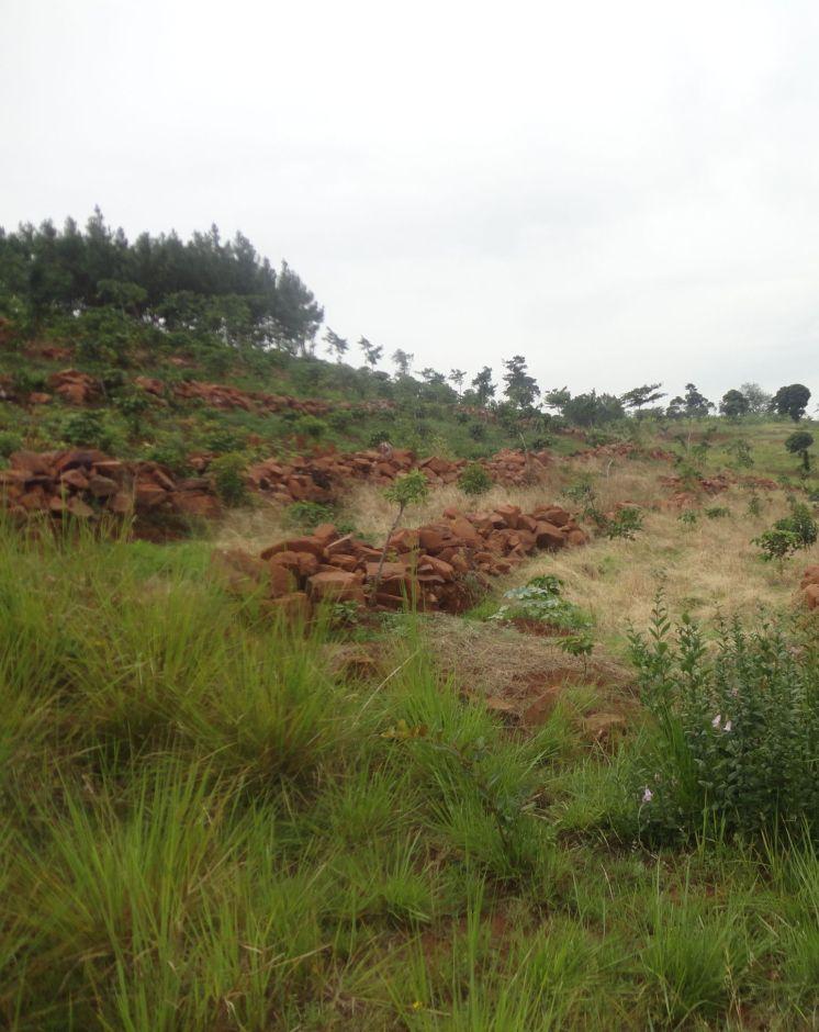
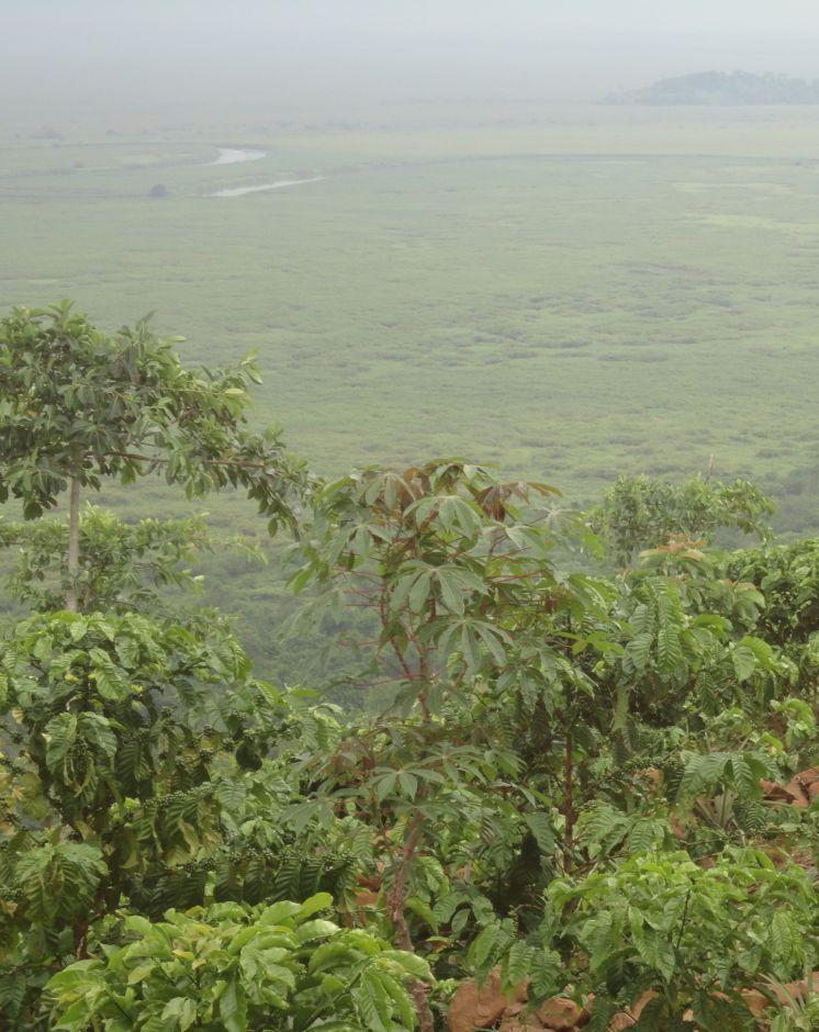
Most of the traditional cropland in Rakai District is fairly flat. However, there are many hectares of very steep, stony, wind-swept slopes facing the Kagera River Valley and Lake Victoria. These slopes have been degraded for a long time because when it rains the runoff is very fast and carries away soil and crops. The swampy Kagera river flood plains below the slopes are fertile because of the deposits of top soil carried from the slopes. Over the last 3 years, farmers have changed from the traditional farming practice where cultivation was done with little or no protection of soil and water movement on the steep slopes to using stone lines along a contour. The stone lines are arranged along the contour to act as a barrier that slows down the speed of water and soil, improve infiltration, mitigate land slides and trap sediment thereby reducing the extent of erosion.
Purpose of the Technology: The technical objective of stone lines is to minimize water and soil movement down the slope and, over time, enable the building of a terrace from the accumulation of soil on the upper side of the barrier.
Establishment / maintenance activities and inputs: The stones are arranged along the contour, guided by a rope. The contour is determined using an A-Frame. The other tools required to establish stone lines are hand hoes, pick axes, and pangas. Establishment requires a lot of labor by which the following activities are accomplished: (i) stones exposed by decades of runoff on hillsides are dug up, collected and placed along contours in a field 200 m by 300 m. The width of each stone line is 0.4 m to 0.6 m and 0.5 m high. The length is dependent on the size of the field across the slope. The spacing from one line to another is 8 m to 12 m, depending on the steepness of the slope. (ii) The exposed sandy loam top soil is very dry and dusty even in the rainy season. Digging with hand hoes loosens the soil. (iii) Following the contour, circular pits of 0.45 m diameter and 0.3 m depth are dug 1.50 m apart, in the middle of every 2 stone lines. In these holes, robusta coffee seedlings are planted. (iv) Beans may be planted throughout the field as a cover crop. The farmer field school (FFS) approach is used because many farmers participate together in completing the establishment tasks. The stone lines are maintained by ensuring that stones which move off the main line are put back and the weeds which grow among the stones are removed to avoid competition with the main crops.
Natural / human environment: There is no known threat to stone lines once they have been established. The runoff cannot gather enough speed between the lines to sweep the stones away because of the short distance. The main offsite benefit is that sediment deposits and water runoff do not destroy crops in the valley below and the Kagera River is protected from silting.
2.3 Photos of the Technology
Media Gallery
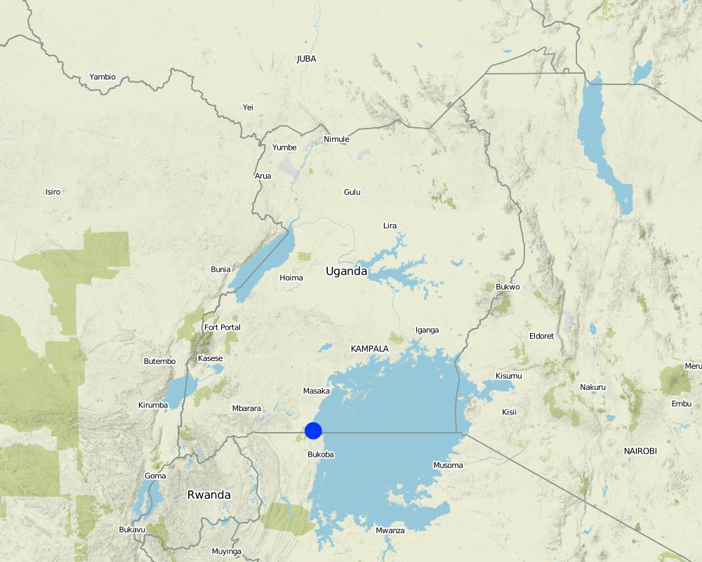
2.5 Country/ region/ locations where the Technology has been applied and which are covered by this assessment
Country:
Uganda
Region/ State/ Province:
Uganda
Further specification of location:
Rakai District
Comments:
Boundary points of the Technology area: -0.96681 31.69066; -0.96706 31.69111; -0.96717 31.69033; -0.96757 31.69038; -0.96774 31.69073
Total area covered by the SLM Technology is 0.06 km2.
Currently about 3 ha but the area is still being expanded by the farmers.
Map
×2.6 Date of implementation
If precise year is not known, indicate approximate date:
- less than 10 years ago (recently)
2.7 Introduction of the Technology
Specify how the Technology was introduced:
- through projects/ external interventions
Comments (type of project, etc.):
Introduced and supported by Kagera TAMP as an SLM technology
3. Classification of the SLM Technology
3.1 Main purpose(s) of the Technology
- reduce, prevent, restore land degradation
3.2 Current land use type(s) where the Technology is applied

Cropland
- Annual cropping
- Perennial (non-woody) cropping
- Tree and shrub cropping
Annual cropping - Specify crops:
- cereals - maize
- legumes and pulses - beans
- root/tuber crops - potatoes
Perennial (non-woody) cropping - Specify crops:
- banana/plantain/abaca
Tree and shrub cropping - Specify crops:
- coffee, open grown
Number of growing seasons per year:
- 2
Specify:
Longest growing period in days: 150 Longest growing period from month to month: February to June Second longest growing period in days: 120 Second longest growing period from month to month: September to November
Comments:
Major land use problems (compiler’s opinion): Surface soil erosion is rampant, carrying away all the top soil with valuable nutrients towards to the marshes below.
Major land use problems (land users’ perception): The land is infertile and no crops can grow in that area.
3.5 SLM group to which the Technology belongs
- cross-slope measure
3.6 SLM measures comprising the Technology

structural measures
- S6: Walls, barriers, palisades, fences
Comments:
Main measures: structural measures
3.7 Main types of land degradation addressed by the Technology

soil erosion by water
- Wt: loss of topsoil/ surface erosion
- Wo: offsite degradation effects
Comments:
Main type of degradation addressed: Wt: loss of topsoil / surface erosion
Secondary types of degradation addressed: Wo: offsite degradation effects
Main causes of degradation: deforestation / removal of natural vegetation (incl. forest fires) (Deforestation for fuel wood and agricultural land), education, access to knowledge and support services (inadequate agricultural extension services)
3.8 Prevention, reduction, or restoration of land degradation
Specify the goal of the Technology with regard to land degradation:
- reduce land degradation
- restore/ rehabilitate severely degraded land
Comments:
Main goals: mitigation / reduction of land degradation
Secondary goals: rehabilitation / reclamation of denuded land
4. Technical specifications, implementation activities, inputs, and costs
4.1 Technical drawing of the Technology
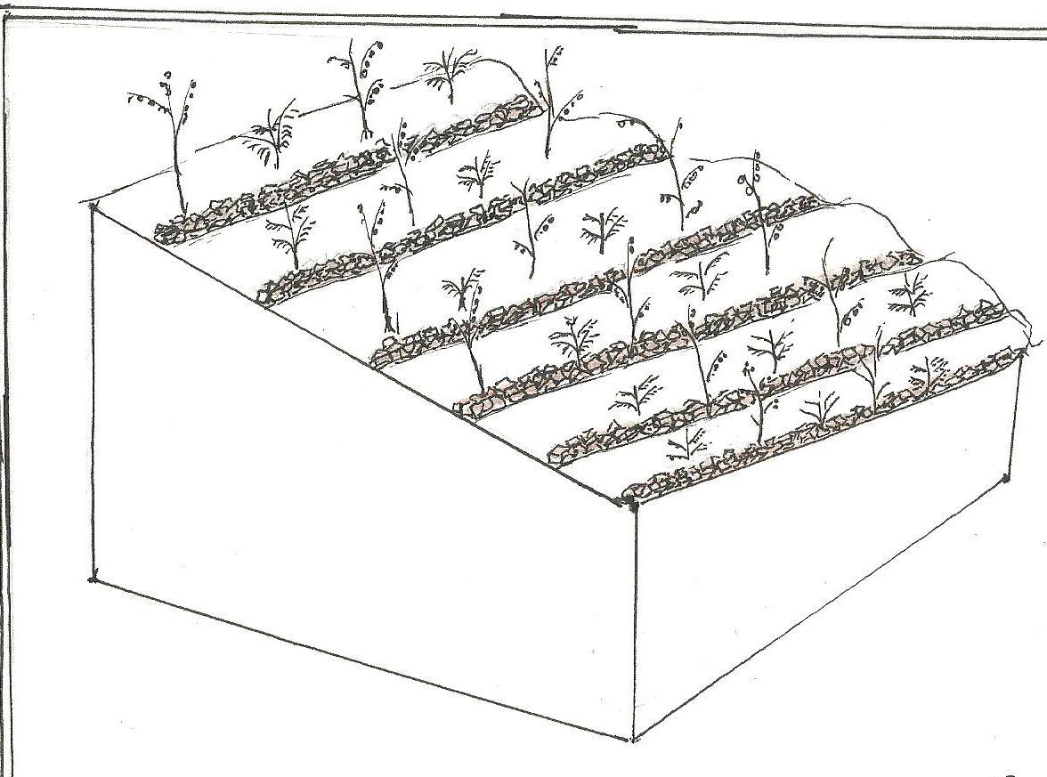
Technical specifications (related to technical drawing):
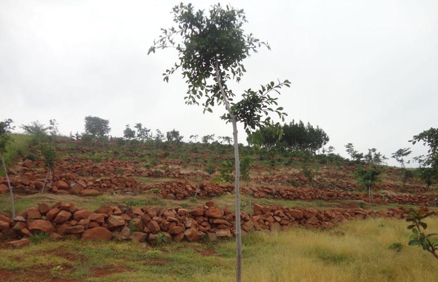
Stone lines on a steep slope. In between is a young coffee plantation.
Location: Katongero. Rakai District
Date: 5-DEC-2013
Technical knowledge required for field staff / advisors: moderate (Technical skill required is keeping the line on the contour)
Technical knowledge required for land users: low (No prior knowledge required)
Main technical functions: control of dispersed runoff: impede / retard, increase of infiltration, sediment retention / trapping, sediment harvesting
Secondary technical functions: reduction of slope length, water harvesting / increase water supply
Wall/ barrier
Vertical interval between structures (m): 3
Spacing between structures (m): n/a
Depth of ditches/pits/dams (m): n/a
Width of ditches/pits/dams (m): n/a
Length of ditches/pits/dams (m): n/a
Height of bunds/banks/others (m): 0.3
Width of bunds/banks/others (m): 0.3
Length of bunds/banks/others (m): 300
Construction material (stone): Big and small stones piled to 0.3 m high, 300 m along a contour
Slope (which determines the spacing indicated above): 38-45%
Lateral gradient along the structure: < 1%
Author:
Byonabye Proscovia, Kagera TAMP, Kabale
4.2 General information regarding the calculation of inputs and costs
other/ national currency (specify):
UGX
If relevant, indicate exchange rate from USD to local currency (e.g. 1 USD = 79.9 Brazilian Real): 1 USD =:
2500.0
Indicate average wage cost of hired labour per day:
10000.00
4.3 Establishment activities
| Activity | Timing (season) | |
|---|---|---|
| 1. | Collection and laying of stones | Dry season |
4.4 Costs and inputs needed for establishment
| Specify input | Unit | Quantity | Costs per Unit | Total costs per input | % of costs borne by land users | |
|---|---|---|---|---|---|---|
| Labour | Labour | ha | 1.0 | 1200.0 | 1200.0 | 100.0 |
| Equipment | Tools | ha | 1.0 | 60.0 | 60.0 | 100.0 |
| Total costs for establishment of the Technology | 1260.0 | |||||
| Total costs for establishment of the Technology in USD | 0.5 | |||||
Comments:
Duration of establishment phase: 12 month(s)
4.5 Maintenance/ recurrent activities
| Activity | Timing/ frequency | |
|---|---|---|
| 1. | Repair of lines | wet season |
4.6 Costs and inputs needed for maintenance/ recurrent activities (per year)
| Specify input | Unit | Quantity | Costs per Unit | Total costs per input | % of costs borne by land users | |
|---|---|---|---|---|---|---|
| Labour | Labour | ha | 1.0 | 120.0 | 120.0 | 100.0 |
| Total costs for maintenance of the Technology | 120.0 | |||||
| Total costs for maintenance of the Technology in USD | 0.05 | |||||
Comments:
Machinery/ tools: n/a
The calculations reflect costs of establishing the technology on a steep slope (38% to 45%) in December of 2013.
4.7 Most important factors affecting the costs
Describe the most determinate factors affecting the costs:
Labor is the factor that influences costs. Digging up and carrying stones up and across slopes is a labor intensive activity.
5. Natural and human environment
5.1 Climate
Annual rainfall
- < 250 mm
- 251-500 mm
- 501-750 mm
- 751-1,000 mm
- 1,001-1,500 mm
- 1,501-2,000 mm
- 2,001-3,000 mm
- 3,001-4,000 mm
- > 4,000 mm
Specifications/ comments on rainfall:
1501-2000 mm (Ranked 1, 1950 mm)
1001-1500 mm (Ranked 2, To a limited extend)
Agro-climatic zone
- humid
Thermal climate class: tropics. LGP >270 days
5.2 Topography
Slopes on average:
- flat (0-2%)
- gentle (3-5%)
- moderate (6-10%)
- rolling (11-15%)
- hilly (16-30%)
- steep (31-60%)
- very steep (>60%)
Landforms:
- plateau/plains
- ridges
- mountain slopes
- hill slopes
- footslopes
- valley floors
Altitudinal zone:
- 0-100 m a.s.l.
- 101-500 m a.s.l.
- 501-1,000 m a.s.l.
- 1,001-1,500 m a.s.l.
- 1,501-2,000 m a.s.l.
- 2,001-2,500 m a.s.l.
- 2,501-3,000 m a.s.l.
- 3,001-4,000 m a.s.l.
- > 4,000 m a.s.l.
Indicate if the Technology is specifically applied in:
- concave situations
Comments and further specifications on topography:
Altitudinal zone: 1001-1500 m a.s.l. (1270 m to 1300 m a.s.l.)
Slopes on average: Steep (ranked 1, the slopes of Rakai district where the technology is applied are steep) and moderate (ranked 2, to a limited extent, towards the top of the hill)
5.3 Soils
Soil depth on average:
- very shallow (0-20 cm)
- shallow (21-50 cm)
- moderately deep (51-80 cm)
- deep (81-120 cm)
- very deep (> 120 cm)
Soil texture (topsoil):
- medium (loamy, silty)
Topsoil organic matter:
- low (<1%)
If available, attach full soil description or specify the available information, e.g. soil type, soil PH/ acidity, Cation Exchange Capacity, nitrogen, salinity etc.
Soil fertility: Medium
Soil drainage/infiltration: Good
Soil water storage capacity: Low
5.4 Water availability and quality
Ground water table:
> 50 m
Availability of surface water:
medium
Water quality (untreated):
poor drinking water (treatment required)
5.5 Biodiversity
Species diversity:
- low
5.6 Characteristics of land users applying the Technology
Market orientation of production system:
- subsistence (self-supply)
Off-farm income:
- less than 10% of all income
Relative level of wealth:
- average
Individuals or groups:
- individual/ household
Level of mechanization:
- manual work
Gender:
- women
- men
Indicate other relevant characteristics of the land users:
Land users applying the Technology are mainly common / average land users
Difference in the involvement of women and men: Men and women work together
Population density: 50-100 persons/km2
Annual population growth: 2% - 3%
and own 20% of the land.
and own 20% of the land.
70% of the land users are average wealthy and own 50% of the land (All land users currently applying the technology are average users).
and own 10% of the land.
Off-farm income specification: Farming is mostly subsistence
Level of mechanization: Manual work (no other form is used in the area)
Market orientation: Subsistence (mostly)
5.7 Average area of land used by land users applying the Technology
- < 0.5 ha
- 0.5-1 ha
- 1-2 ha
- 2-5 ha
- 5-15 ha
- 15-50 ha
- 50-100 ha
- 100-500 ha
- 500-1,000 ha
- 1,000-10,000 ha
- > 10,000 ha
Is this considered small-, medium- or large-scale (referring to local context)?
- small-scale
Comments:
Average area of land owned or leased by land users applying the Technology: Also 1-2 ha and 5-15 ha (both ranked 2)
5.8 Land ownership, land use rights, and water use rights
Land ownership:
- individual, not titled
Land use rights:
- individual
Water use rights:
- open access (unorganized)
5.9 Access to services and infrastructure
health:
- poor
- moderate
- good
education:
- poor
- moderate
- good
technical assistance:
- poor
- moderate
- good
employment (e.g. off-farm):
- poor
- moderate
- good
markets:
- poor
- moderate
- good
energy:
- poor
- moderate
- good
roads and transport:
- poor
- moderate
- good
drinking water and sanitation:
- poor
- moderate
- good
financial services:
- poor
- moderate
- good
6. Impacts and concluding statements
6.1 On-site impacts the Technology has shown
Socio-economic impacts
Production
crop production
production area
Income and costs
farm income
workload
Comments/ specify:
The hard labor is a challenge to women and children who play a major role in cultivation
Socio-cultural impacts
community institutions
conflict mitigation
Improved livelihoods and human well-being
Comments/ specify:
There is more arable land, reducing pressure on land and generally improving productivity.
Ecological impacts
Water cycle/ runoff
surface runoff
Soil
soil moisture
soil loss
soil organic matter/ below ground C
Biodiversity: vegetation, animals
biomass/ above ground C
plant diversity
pest/ disease control
Comments/ specify:
May harbor weeds and crop pests
6.2 Off-site impacts the Technology has shown
downstream flooding
downstream siltation
groundwater/ river pollution
6.3 Exposure and sensitivity of the Technology to gradual climate change and climate-related extremes/ disasters (as perceived by land users)
Gradual climate change
Gradual climate change
| Season | increase or decrease | How does the Technology cope with it? | |
|---|---|---|---|
| annual temperature | increase | well |
Climate-related extremes (disasters)
Meteorological disasters
| How does the Technology cope with it? | |
|---|---|
| local rainstorm | well |
Climatological disasters
| How does the Technology cope with it? | |
|---|---|
| drought | well |
Other climate-related consequences
Other climate-related consequences
| How does the Technology cope with it? | |
|---|---|
| reduced growing period | well |
Comments:
n/a
6.4 Cost-benefit analysis
How do the benefits compare with the establishment costs (from land users’ perspective)?
Long-term returns:
very positive
How do the benefits compare with the maintenance/ recurrent costs (from land users' perspective)?
Long-term returns:
very positive
6.5 Adoption of the Technology
If available, quantify (no. of households and/ or area covered):
15
Of all those who have adopted the Technology, how many did so spontaneously, i.e. without receiving any material incentives/ payments?
- 91-100%
Comments:
100% of land user families have adopted the Technology without any external material support
15 land user families have adopted the Technology without any external material support
Comments on spontaneous adoption: Adoption has been spontaneous, through farmer to farmer learning
There is a moderate trend towards spontaneous adoption of the Technology
Comments on adoption trend: The technology has been mainly taken up by members of Farmer Field School. The labor cost makes it too demanding for an individual but some households with several members in the family have adopted outside the FFS method.
6.7 Strengths/ advantages/ opportunities of the Technology
| Strengths/ advantages/ opportunities in the land user’s view |
|---|
|
Having more land means more options for crop diversity How can they be sustained / enhanced? Scale up the technology |
|
There is improved food security How can they be sustained / enhanced? Establish stone lines on more disused land |
| Strengths/ advantages/ opportunities in the compiler’s or other key resource person’s view |
|---|
|
Increases cropland available for cultivation How can they be sustained / enhanced? Sustain adoption through farmer-to-farmer visits |
|
Increases rain water infiltration, reducing flooding offsite How can they be sustained / enhanced? Encourage government to scale up the technology |
|
Stone lines are robust and require little maintenance once established How can they be sustained / enhanced? Help farmers adopt because sustainability is easy |
|
Offsite benefits are as important as they are onsite How can they be sustained / enhanced? Encourage catchment level participation including downstream farmers |
6.8 Weaknesses/ disadvantages/ risks of the Technology and ways of overcoming them
| Weaknesses/ disadvantages/ risks in the land user’s view | How can they be overcome? |
|---|---|
| It has become more expensive to hire labor for other farm activities | Work in groups, one farm at a time |
| Weaknesses/ disadvantages/ risks in the compiler’s or other key resource person’s view | How can they be overcome? |
|---|---|
| Expensive to the farmer | Help government and the private sector to subsidize cost to the farmer |
| Labor to dig up and transport stones is very heavy | Encourage community level approach like Farmer field School |
7. References and links
7.1 Methods/ sources of information
7.2 References to available publications
Title, author, year, ISBN:
Kagera TAMP project website
Available from where? Costs?
http://www.fao.org/nr/kagera/en/
Links and modules
Expand all Collapse allLinks
FFS/SLM Community Initiative [Uganda]
Farmers are organized to promote adoption of sustainable land management best practices within the community
- Compiler: Wilson Bamwerinde
Modules
No modules