Stone lines [ยูกันดา]
- ผู้สร้างสรรค์:
- การอัพเดท:
- ผู้รวบรวม: Wilson Bamwerinde
- ผู้เรียบเรียง: –
- ผู้ตรวจสอบ: Fabian Ottiger, Alexandra Gavilano
Ennyiriri z'amayinja eziziyiza ettaka okutwalibwa enkuba (Luganda)
technologies_1589 - ยูกันดา
ดูส่วนย่อย
ขยายทั้งหมด ย่อทั้งหมด1. ข้อมูลทั่วไป
1.2 รายละเอียดที่ติดต่อได้ของผู้รวบรวมและองค์กรที่เกี่ยวข้องในการประเมินและการจัดเตรียมทำเอกสารของเทคโนโลยี
ผู้เชี่ยวชาญ SLM:
ผู้เชี่ยวชาญ SLM:
ชื่อของโครงการซึ่งอำนวยความสะดวกในการทำเอกสารหรือการประเมินเทคโนโลยี (ถ้าเกี่ยวข้อง)
The Transboundary Agro-ecosystem Management Project for the Kagera River Basin (GEF-FAO / Kagera TAMP )ชื่อขององค์กรซึ่งอำนวยความสะดวกในการทำเอกสารหรือการประเมินเทคโนโลยี (ถ้าเกี่ยวข้อง)
Food and Agriculture Organization of the United Nations (FAO) - อิตาลี1.3 เงื่อนไขการใช้ข้อมูลที่ได้บันทึกผ่านทาง WOCAT
ผู้รวบรวมและวิทยากรหลักยอมรับเงื่อนไขเกี่ยวกับการใช้ข้อมูลที่ถูกบันทึกผ่านทาง WOCAT:
ใช่
1.5 Reference to Questionnaire(s) on SLM Approaches (documented using WOCAT)

FFS/SLM Community Initiative [ยูกันดา]
Farmers are organized to promote adoption of sustainable land management best practices within the community
- ผู้รวบรวม: Wilson Bamwerinde
2. การอธิบายลักษณะของเทคโนโลยี SLM
2.1 การอธิบายแบบสั้น ๆ ของเทคโนโลยี
คำจำกัดความของเทคโนโลยี:
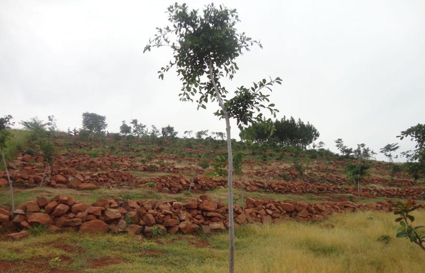
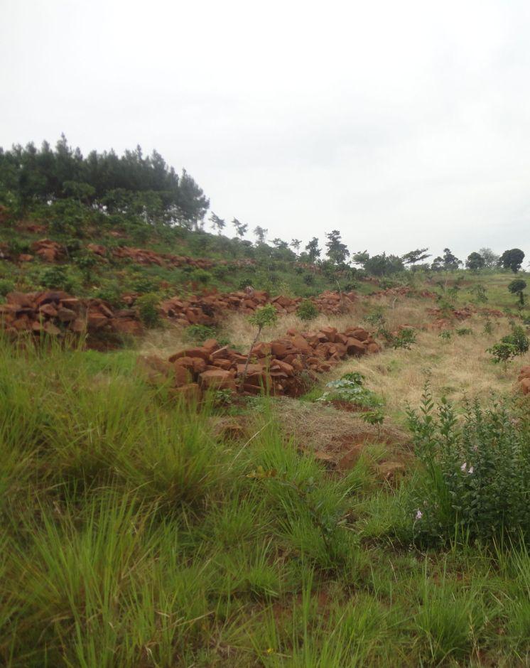
Stone lines are built along a contour to control soil erosion on a degraded steep slope.
2.2 การอธิบายแบบละเอียดของเทคโนโลยี
คำอธิบาย:
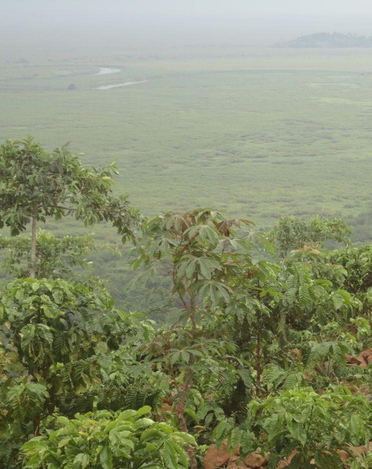
Most of the traditional cropland in Rakai District is fairly flat. However, there are many hectares of very steep, stony, wind-swept slopes facing the Kagera River Valley and Lake Victoria. These slopes have been degraded for a long time because when it rains the runoff is very fast and carries away soil and crops. The swampy Kagera river flood plains below the slopes are fertile because of the deposits of top soil carried from the slopes. Over the last 3 years, farmers have changed from the traditional farming practice where cultivation was done with little or no protection of soil and water movement on the steep slopes to using stone lines along a contour. The stone lines are arranged along the contour to act as a barrier that slows down the speed of water and soil, improve infiltration, mitigate land slides and trap sediment thereby reducing the extent of erosion.
Purpose of the Technology: The technical objective of stone lines is to minimize water and soil movement down the slope and, over time, enable the building of a terrace from the accumulation of soil on the upper side of the barrier.
Establishment / maintenance activities and inputs: The stones are arranged along the contour, guided by a rope. The contour is determined using an A-Frame. The other tools required to establish stone lines are hand hoes, pick axes, and pangas. Establishment requires a lot of labor by which the following activities are accomplished: (i) stones exposed by decades of runoff on hillsides are dug up, collected and placed along contours in a field 200 m by 300 m. The width of each stone line is 0.4 m to 0.6 m and 0.5 m high. The length is dependent on the size of the field across the slope. The spacing from one line to another is 8 m to 12 m, depending on the steepness of the slope. (ii) The exposed sandy loam top soil is very dry and dusty even in the rainy season. Digging with hand hoes loosens the soil. (iii) Following the contour, circular pits of 0.45 m diameter and 0.3 m depth are dug 1.50 m apart, in the middle of every 2 stone lines. In these holes, robusta coffee seedlings are planted. (iv) Beans may be planted throughout the field as a cover crop. The farmer field school (FFS) approach is used because many farmers participate together in completing the establishment tasks. The stone lines are maintained by ensuring that stones which move off the main line are put back and the weeds which grow among the stones are removed to avoid competition with the main crops.
Natural / human environment: There is no known threat to stone lines once they have been established. The runoff cannot gather enough speed between the lines to sweep the stones away because of the short distance. The main offsite benefit is that sediment deposits and water runoff do not destroy crops in the valley below and the Kagera River is protected from silting.
2.3 รูปภาพของเทคโนโลยี
อัลบั้มสื่อบันทึก
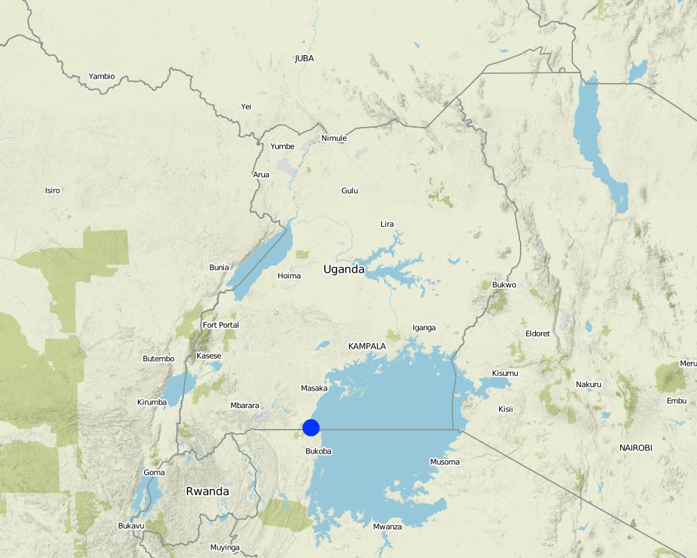
2.5 ประเทศภูมิภาค หรือสถานที่ตั้งที่เทคโนโลยีได้นำไปใช้และได้รับการครอบคลุมโดยการประเมินนี้
ประเทศ:
ยูกันดา
ภูมิภาค/รัฐ/จังหวัด:
Uganda
ข้อมูลจำเพาะเพิ่มเติมของสถานที่ตั้ง :
Rakai District
แสดงความคิดเห็น:
Boundary points of the Technology area: -0.96681 31.69066; -0.96706 31.69111; -0.96717 31.69033; -0.96757 31.69038; -0.96774 31.69073
Total area covered by the SLM Technology is 0.06 km2.
Currently about 3 ha but the area is still being expanded by the farmers.
Map
×2.6 วันที่การดำเนินการ
ถ้าไม่รู้ปีที่แน่นอน ให้ระบุวันที่โดยประมาณ:
- น้อยกว่า 10 ปี (ไม่นานนี้)
2.7 คำแนะนำของเทคโนโลยี
ให้ระบุว่าเทคโนโลยีถูกแนะนำเข้ามาอย่างไร:
- ทางโครงการหรือจากภายนอก
ความคิดเห็น (ประเภทของโครงการ เป็นต้น) :
Introduced and supported by Kagera TAMP as an SLM technology
3. การจัดประเภทของเทคโนโลยี SLM
3.1 วัตถุประสงค์หลักของเทคโนโลยี
- ลด ป้องกัน ฟื้นฟู การเสื่อมโทรมของที่ดิน
3.2 ประเภทของการใช้ที่ดินในปัจจุบันที่ได้นำเทคโนโลยีไปใช้

พื้นที่ปลูกพืช
- การปลูกพืชล้มลุกอายุปีเดียว
- การปลูกพืชยืนต้นที่ไม่มีเนื้อไม้
- การปลูกไม้ยืนต้น ไม้พุ่ม
Annual cropping - Specify crops:
- cereals - maize
- legumes and pulses - beans
- root/tuber crops - potatoes
Perennial (non-woody) cropping - Specify crops:
- banana/plantain/abaca
Tree and shrub cropping - Specify crops:
- coffee, open grown
จำนวนของฤดูเพาะปลูกต่อปี:
- 2
ระบุ:
Longest growing period in days: 150 Longest growing period from month to month: February to June Second longest growing period in days: 120 Second longest growing period from month to month: September to November
แสดงความคิดเห็น:
Major land use problems (compiler’s opinion): Surface soil erosion is rampant, carrying away all the top soil with valuable nutrients towards to the marshes below.
Major land use problems (land users’ perception): The land is infertile and no crops can grow in that area.
3.5 กลุ่ม SLM ที่ตรงกับเทคโนโลยีนี้
- มาตรการปลูกพืชขวางความลาดชัน (cross-slope measure)
3.6 มาตรการ SLM ที่ประกอบกันเป็นเทคโนโลยี

มาตรการอนุรักษ์ด้วยโครงสร้าง
- S6: กำแพง สิ่งกีดขวาง รั้วไม้ รั้วต่างๆ
แสดงความคิดเห็น:
Main measures: structural measures
3.7 รูปแบบหลักของการเสื่อมโทรมของที่ดินที่ได้รับการแก้ไขโดยเทคโนโลยี

การกัดกร่อนของดินโดยน้ำ
- Wt (Loss of topsoil): การสูญเสียดินชั้นบนหรือการกัดกร่อนที่ผิวดิน
- Wo (Offsite degradation): ผลกระทบนอกพื้นที่
แสดงความคิดเห็น:
Main type of degradation addressed: Wt: loss of topsoil / surface erosion
Secondary types of degradation addressed: Wo: offsite degradation effects
Main causes of degradation: deforestation / removal of natural vegetation (incl. forest fires) (Deforestation for fuel wood and agricultural land), education, access to knowledge and support services (inadequate agricultural extension services)
3.8 การป้องกัน การลดลง หรือการฟื้นฟูความเสื่อมโทรมของที่ดิน
ระบุเป้าหมายของเทคโนโลยีกับความเสื่อมโทรมของที่ดิน:
- ลดความเสื่อมโทรมของดิน
- ฟื้นฟูบำบัดที่ดินที่เสื่อมโทรมลงอย่างมาก
แสดงความคิดเห็น:
Main goals: mitigation / reduction of land degradation
Secondary goals: rehabilitation / reclamation of denuded land
4. ข้อมูลจำเพาะด้านเทคนิค กิจกรรมการนำไปปฏิบัติใช้ ปัจจัยนำเข้า และค่าใช้จ่าย
4.1 แบบแปลนทางเทคนิคของเทคโนโลยี
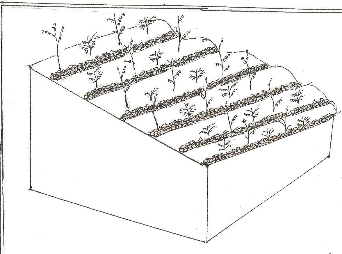
ข้อมูลจำเพาะด้านเทคนิค (แบบแปลนทางเทคนิคของเทคโนโลยี):
Stone lines on a steep slope. In between is a young coffee plantation.
Location: Katongero. Rakai District
Date: 5-DEC-2013
Technical knowledge required for field staff / advisors: moderate (Technical skill required is keeping the line on the contour)
Technical knowledge required for land users: low (No prior knowledge required)
Main technical functions: control of dispersed runoff: impede / retard, increase of infiltration, sediment retention / trapping, sediment harvesting
Secondary technical functions: reduction of slope length, water harvesting / increase water supply
Wall/ barrier
Vertical interval between structures (m): 3
Spacing between structures (m): n/a
Depth of ditches/pits/dams (m): n/a
Width of ditches/pits/dams (m): n/a
Length of ditches/pits/dams (m): n/a
Height of bunds/banks/others (m): 0.3
Width of bunds/banks/others (m): 0.3
Length of bunds/banks/others (m): 300
Construction material (stone): Big and small stones piled to 0.3 m high, 300 m along a contour
Slope (which determines the spacing indicated above): 38-45%
Lateral gradient along the structure: < 1%
ผู้เขียน:
Byonabye Proscovia, Kagera TAMP, Kabale
4.2 ข้อมูลทั่วไปเกี่ยวกับการคำนวณปัจจัยนำเข้าและค่าใช้จ่าย
อื่นๆ หรือสกุลเงินประจำชาติ (ระบุ):
UGX
If relevant, indicate exchange rate from USD to local currency (e.g. 1 USD = 79.9 Brazilian Real): 1 USD =:
2500.0
ระบุค่าเฉลี่ยของค่าจ้างในการจ้างแรงงานต่อวัน:
10000.00
4.3 กิจกรรมเพื่อการจัดตั้ง
| กิจกรรม | Timing (season) | |
|---|---|---|
| 1. | Collection and laying of stones | Dry season |
4.4 ค่าใช้จ่ายของปัจจัยนำเข้าที่จำเป็นสำหรับการจัดตั้ง
| ปัจจัยนำเข้า | หน่วย | ปริมาณ | ค่าใช้จ่ายต่อหน่วย | ค่าใช้จ่ายทั้งหมดต่อปัจจัยนำเข้า | %ของค่าใช้จ่ายที่ก่อให้เกิดขึ้นโดยผู้ใช้ที่ดิน | |
|---|---|---|---|---|---|---|
| แรงงาน | Labour | ha | 1.0 | 1200.0 | 1200.0 | 100.0 |
| อุปกรณ์ | Tools | ha | 1.0 | 60.0 | 60.0 | 100.0 |
| ค่าใช้จ่ายทั้งหมดของการจัดตั้งเทคโนโลยี | 1260.0 | |||||
| Total costs for establishment of the Technology in USD | 0.5 | |||||
แสดงความคิดเห็น:
Duration of establishment phase: 12 month(s)
4.5 การบำรุงรักษาสภาพหรือกิจกรรมที่เกิดขึ้นเป็นประจำ
| กิจกรรม | ช่วงระยะเวลา/ความถี่ | |
|---|---|---|
| 1. | Repair of lines | wet season |
4.6 ค่าใช้จ่ายของปัจจัยนำเข้าและกิจกรรมที่เกิดขึ้นเป็นประจำที่ต้องการการบำรุงรักษา (ต่อปี)
| ปัจจัยนำเข้า | หน่วย | ปริมาณ | ค่าใช้จ่ายต่อหน่วย | ค่าใช้จ่ายทั้งหมดต่อปัจจัยนำเข้า | %ของค่าใช้จ่ายที่ก่อให้เกิดขึ้นโดยผู้ใช้ที่ดิน | |
|---|---|---|---|---|---|---|
| แรงงาน | Labour | ha | 1.0 | 120.0 | 120.0 | 100.0 |
| ค่าใช้จ่ายทั้งหมดของการบำรุงรักษาสภาพเทคโนโลยี | 120.0 | |||||
| Total costs for maintenance of the Technology in USD | 0.05 | |||||
แสดงความคิดเห็น:
Machinery/ tools: n/a
The calculations reflect costs of establishing the technology on a steep slope (38% to 45%) in December of 2013.
4.7 ปัจจัยสำคัญที่สุดที่มีผลกระทบต่อค่าใช้จ่าย
ปัจจัยสำคัญที่สุดที่มีผลกระทบต่อค่าใช้จ่ายต่างๆ:
Labor is the factor that influences costs. Digging up and carrying stones up and across slopes is a labor intensive activity.
5. สิ่งแวดล้อมทางธรรมชาติและของมนุษย์
5.1 ภูมิอากาศ
ฝนประจำปี
- < 250 ม.ม.
- 251-500 ม.ม.
- 501-750 ม.ม.
- 751-1,000 ม.ม.
- 1,001-1,500 ม.ม.
- 1,501-2,000 ม.ม.
- 2,001-3,000 ม.ม.
- 3,001-4,000 ม.ม.
- > 4,000 ม.ม.
ข้อมูลจำเพาะ/ความคิดเห็นเรื่องปริมาณน้ำฝน:
1501-2000 mm (Ranked 1, 1950 mm)
1001-1500 mm (Ranked 2, To a limited extend)
เขตภูมิอากาศเกษตร
- ชื้น
Thermal climate class: tropics. LGP >270 days
5.2 สภาพภูมิประเทศ
ค่าเฉลี่ยความลาดชัน:
- ราบเรียบ (0-2%)
- ลาดที่ไม่ชัน (3-5%)
- ปานกลาง (6-10%)
- เป็นลูกคลื่น (11-15%)
- เป็นเนิน (16-30%)
- ชัน (31-60%)
- ชันมาก (>60%)
ธรณีสัณฐาน:
- ที่ราบสูง/ที่ราบ
- สันเขา
- ไหล่เขา
- ไหล่เนินเขา
- ตีนเนิน
- หุบเขา
ระดับความสูง:
- 0-100 เมตร
- 101-500 เมตร
- 501-1,000 เมตร
- 1,001-1,500 เมตร
- 1,501-2,000 เมตร
- 2,001-2,500 เมตร
- 2,501-3,000 เมตร
- 3,001-4,000 เมตร
- > 4,000 เมตร
ให้ระบุถ้าเทคโนโลยีได้ถูกนำไปใช้:
- บริเวณแอ่งบนที่ราบ (concave situations)
ความคิดเห็นและข้อมูลจำเพาะเพิ่มเติมเรื่องสภาพภูมิประเทศ:
Altitudinal zone: 1001-1500 m a.s.l. (1270 m to 1300 m a.s.l.)
Slopes on average: Steep (ranked 1, the slopes of Rakai district where the technology is applied are steep) and moderate (ranked 2, to a limited extent, towards the top of the hill)
5.3 ดิน
ค่าเฉลี่ยความลึกของดิน:
- ตื้นมาก (0-20 ซ.ม.)
- ตื้น (21-50 ซ.ม.)
- ลึกปานกลาง (51-80 ซ.ม.)
- ลึก (81-120 ซ.ม.)
- ลึกมาก (>120 ซ.ม.)
เนื้อดิน (ดินชั้นบน):
- ปานกลาง (ดินร่วน ทรายแป้ง)
อินทรียวัตถุในดิน:
- ต่ำ (<1%)
(ถ้ามี) ให้แนบคำอธิบายเรื่องดินแบบเต็มหรือระบุข้อมูลที่มีอยู่ เช่น ชนิดของดิน ค่า pH ของดินหรือความเป็นกรดของดิน ความสามารถในการแลกเปลี่ยนประจุบวก ไนโตรเจน ความเค็ม เป็นต้น:
Soil fertility: Medium
Soil drainage/infiltration: Good
Soil water storage capacity: Low
5.4 ความเป็นประโยชน์และคุณภาพของน้ำ
ระดับน้ำใต้ดิน:
> 50 เมตร
น้ำไหลบ่าที่ผิวดิน:
ปานกลาง
คุณภาพน้ำ (ที่ยังไม่ได้บำบัด):
เป็นน้ำเพื่อการดื่มที่ไม่ดี (จำเป็นต้องได้รับการบำบัด)
5.5 ความหลากหลายทางชีวภาพ
ความหลากหลายทางชนิดพันธุ์:
- ต่ำ
5.6 ลักษณะของผู้ใช้ที่ดินที่นำเทคโนโลยีไปปฏิบัติใช้
แนวทางการตลาดของระบบการผลิต:
- เพื่อการยังชีพ (หาเลี้ยงตนเอง)
รายได้ที่มาจากนอกฟาร์ม:
- < 10% ของรายได้ทั้งหมด
ระดับของความมั่งคั่งโดยเปรียบเทียบ:
- พอมีพอกิน
เป็นรายบุคคล/ครัวเรือน:
- เป็นรายบุคคล/ครัวเรือน
ระดับของการใช้เครื่องจักรกล:
- งานที่ใช้แรงกาย
เพศ:
- หญิง
- ชาย
ระบุลักษณะอื่นๆที่เกี่ยวข้องของผู้ใช้ที่ดิน:
Land users applying the Technology are mainly common / average land users
Difference in the involvement of women and men: Men and women work together
Population density: 50-100 persons/km2
Annual population growth: 2% - 3%
and own 20% of the land.
and own 20% of the land.
70% of the land users are average wealthy and own 50% of the land (All land users currently applying the technology are average users).
and own 10% of the land.
Off-farm income specification: Farming is mostly subsistence
Level of mechanization: Manual work (no other form is used in the area)
Market orientation: Subsistence (mostly)
5.7 Average area of land used by land users applying the Technology
- < 0.5 เฮกตาร์
- 0.5-1 เฮกตาร์
- 1-2 เฮกตาร์
- 2-5 เฮกตาร์
- 5-15 เฮกตาร์
- 15-50 เฮกตาร์
- 50-100 เฮกตาร์
- 100-500 เฮกตาร์
- 500-1,000 เฮกตาร์
- 1,000-10,000 เฮกตาร์
- >10,000 เฮกตาร์
พิจารณาว่าเป็นขนาดเล็ก กลาง หรือขนาดใหญ่ (ซึ่งอ้างอิงถึงบริบทระดับท้องถิ่น):
- ขนาดเล็ก
แสดงความคิดเห็น:
Average area of land owned or leased by land users applying the Technology: Also 1-2 ha and 5-15 ha (both ranked 2)
5.8 กรรมสิทธิ์ในที่ดิน สิทธิในการใช้ที่ดินและสิทธิในการใช้น้ำ
กรรมสิทธิ์ในที่ดิน:
- รายบุคคล ไม่ได้รับสิทธิครอบครอง
สิทธิในการใช้ที่ดิน:
- รายบุคคล
สิทธิในการใช้น้ำ:
- เข้าถึงได้แบบเปิด (ไม่ได้จัดระเบียบ)
5.9 การเข้าถึงบริการและโครงสร้างพื้นฐาน
สุขภาพ:
- จน
- ปานกลาง
- ดี
การศึกษา:
- จน
- ปานกลาง
- ดี
ความช่วยเหลือทางด้านเทคนิค:
- จน
- ปานกลาง
- ดี
การจ้างงาน (เช่น ภายนอกฟาร์ม):
- จน
- ปานกลาง
- ดี
ตลาด:
- จน
- ปานกลาง
- ดี
พลังงาน:
- จน
- ปานกลาง
- ดี
ถนนและการขนส่ง:
- จน
- ปานกลาง
- ดี
น้ำดื่มและการสุขาภิบาล:
- จน
- ปานกลาง
- ดี
บริการด้านการเงิน:
- จน
- ปานกลาง
- ดี
6. ผลกระทบและสรุปคำบอกกล่าว
6.1 ผลกระทบในพื้นที่ดำเนินการ (On-site) จากการใช้เทคโนโลยี
ผลกระทบทางด้านเศรษฐกิจและสังคม
การผลิต
การผลิตพืชผล
พื้นที่สำหรับการผลิต
รายได้และค่าใช้จ่าย
รายได้จากฟาร์ม
ภาระงาน
แสดงความคิดเห็น/ระบุ:
The hard labor is a challenge to women and children who play a major role in cultivation
ผลกระทบด้านสังคมวัฒนธรรมอื่น ๆ
สถาบันของชุมชน
การบรรเทาความขัดแย้ง
Improved livelihoods and human well-being
แสดงความคิดเห็น/ระบุ:
There is more arable land, reducing pressure on land and generally improving productivity.
ผลกระทบด้านนิเวศวิทยา
วัฐจักรน้ำหรือน้ำบ่า
น้ำไหลบ่าที่ผิวดิน
ดิน
ความชื้นในดิน
การสูญเสียดิน
อินทรียวัตถุในดิน/ต่ำกว่าดินชั้น C
ความหลากหลายทางชีวภาพของพืชและสัตว์
มวลชีวภาพ/เหนือดินชั้น C
ความหลากหลายทางชีวภาพของพืช
การจัดการศัตรูพืชและโรคพืช
แสดงความคิดเห็น/ระบุ:
May harbor weeds and crop pests
6.2 ผลกระทบนอกพื้นที่ดำเนินการ (Off-site) จากการใช้เทคโนโลยี
น้ำท่วมพื้นที่ท้ายน้ำ
การทับถมของดินตะกอนพื้นที่ท้ายน้ำ
การเกิดมลพิษในน้ำบาดาลหรือแม่น้ำ
6.3 การเผชิญและความตอบสนองของเทคโนโลยีต่อการเปลี่ยนแปลงสภาพภูมิอากาศที่ค่อยเป็นค่อยไป และสภาพรุนแรงของภูมิอากาศ / ภัยพิบัติ (ที่รับรู้ได้โดยผู้ใช้ที่ดิน)
การเปลี่ยนแปลงสภาพภูมิอากาศที่ค่อยเป็นค่อยไป
การเปลี่ยนแปลงสภาพภูมิอากาศที่ค่อยเป็นค่อยไป
| ฤดู | increase or decrease | เทคโนโลยีมีวิธีการรับมืออย่างไร | |
|---|---|---|---|
| อุณหภูมิประจำปี | เพิ่มขึ้น | ดี |
สภาพรุนแรงของภูมิอากาศ (ภัยพิบัติ)
ภัยพิบัติทางอุตุนิยมวิทยา
| เทคโนโลยีมีวิธีการรับมืออย่างไร | |
|---|---|
| พายุฝนประจำท้องถิ่น | ดี |
ภัยพิบัติจากสภาพภูมิอากาศ
| เทคโนโลยีมีวิธีการรับมืออย่างไร | |
|---|---|
| ภัยจากฝนแล้ง | ดี |
ผลลัพธ์ตามมาที่เกี่ยวข้องกับภูมิอากาศอื่น ๆ
ผลลัพธ์ตามมาที่เกี่ยวข้องกับภูมิอากาศอื่น ๆ
| เทคโนโลยีมีวิธีการรับมืออย่างไร | |
|---|---|
| ช่วงการปลูกพืชที่ลดลงมา | ดี |
แสดงความคิดเห็น:
n/a
6.4 การวิเคราะห์ค่าใช้จ่ายและผลประโยชน์ที่ได้รับ
ผลประโยชน์ที่ได้รับเปรียบเทียบกับค่าใช้จ่ายในการจัดตั้งเป็นอย่างไร (จากมุมมองของผู้ใช้ที่ดิน)
ผลตอบแทนระยะยาว:
ด้านบวกอย่างมาก
ผลประโยชน์ที่ได้รับเปรียบเทียบกับค่าใช้จ่ายในการบำรุงรักษาหรือต้นทุนที่เกิดขึ้นซ้ำอีก เป็นอย่างไร (จากมุมมองของผู้ใช้ที่ดิน)
ผลตอบแทนระยะยาว:
ด้านบวกอย่างมาก
6.5 การปรับตัวของเทคโนโลยี
ถ้ามีข้อมูลให้บอกปริมาณด้วย (จำนวนของครัวเรือนหรือครอบคลุมพื้นที่):
15
Of all those who have adopted the Technology, how many did so spontaneously, i.e. without receiving any material incentives/ payments?
- 91-100%
แสดงความคิดเห็น:
100% of land user families have adopted the Technology without any external material support
15 land user families have adopted the Technology without any external material support
Comments on spontaneous adoption: Adoption has been spontaneous, through farmer to farmer learning
There is a moderate trend towards spontaneous adoption of the Technology
Comments on adoption trend: The technology has been mainly taken up by members of Farmer Field School. The labor cost makes it too demanding for an individual but some households with several members in the family have adopted outside the FFS method.
6.7 จุดแข็ง / ข้อได้เปรียบ / โอกาสของเทคโนโลยี
| จุดแข็ง / ข้อได้เปรียบ / โอกาสในทัศนคติของผู้ใช้ที่ดิน |
|---|
|
Having more land means more options for crop diversity How can they be sustained / enhanced? Scale up the technology |
|
There is improved food security How can they be sustained / enhanced? Establish stone lines on more disused land |
| จุดแข็ง / ข้อได้เปรียบ / โอกาสในทัศนคติของผู้รวบรวมหรือวิทยากรหลัก |
|---|
|
Increases cropland available for cultivation How can they be sustained / enhanced? Sustain adoption through farmer-to-farmer visits |
|
Increases rain water infiltration, reducing flooding offsite How can they be sustained / enhanced? Encourage government to scale up the technology |
|
Stone lines are robust and require little maintenance once established How can they be sustained / enhanced? Help farmers adopt because sustainability is easy |
|
Offsite benefits are as important as they are onsite How can they be sustained / enhanced? Encourage catchment level participation including downstream farmers |
6.8 จุดอ่อน / ข้อเสียเปรียบ / ความเสี่ยงของเทคโนโลยีและวิธีการแก้ไข
| จุดอ่อน / ข้อเสียเปรียบ / ความเสี่ยงในทัศนคติของผู้ใช้ที่ดิน | มีวิธีการแก้ไขได้อย่างไร |
|---|---|
| It has become more expensive to hire labor for other farm activities | Work in groups, one farm at a time |
| จุดอ่อน / ข้อเสียเปรียบ / ความเสี่ยงในทัศนคติของผู้รวบรวมหรือวิทยากรหลัก | มีวิธีการแก้ไขได้อย่างไร |
|---|---|
| Expensive to the farmer | Help government and the private sector to subsidize cost to the farmer |
| Labor to dig up and transport stones is very heavy | Encourage community level approach like Farmer field School |
7. การอ้างอิงและการเชื่อมต่อ
7.1 วิธีการและแหล่งข้อมูล
7.2 การอ้างอิงถึงสิ่งตีพิมพ์
หัวข้อ, ผู้เขียน, ปี, หมายเลข ISBN:
Kagera TAMP project website
ชื่อเรื่อง ผู้เขียน ปี ISBN:
http://www.fao.org/nr/kagera/en/
ลิงก์และโมดูล
ขยายทั้งหมด ย่อทั้งหมดลิงก์
FFS/SLM Community Initiative [ยูกันดา]
Farmers are organized to promote adoption of sustainable land management best practices within the community
- ผู้รวบรวม: Wilson Bamwerinde
โมดูล
ไม่มีโมดูล