Earth checks for Gully reclamation [Ethiopie]
- Création :
- Mise à jour :
- Compilateur : Daniel Danano
- Rédacteur : –
- Examinateurs : Fabian Ottiger, Alexandra Gavilano
technologies_1069 - Ethiopie
Voir les sections
Développer tout Réduire tout1. Informations générales
1.2 Coordonnées des personnes-ressources et des institutions impliquées dans l'évaluation et la documentation de la Technologie
Spécialiste GDT:
Estifanos Zena
Ministry of Agriculture and Rural Development
Ethiopie
Spécialiste GDT:
Desta Hiwot
Boditi, Department of Agriculture and Rural Development
Ethiopie
Nom du ou des institutions qui ont facilité la documentation/ l'évaluation de la Technologie (si pertinent)
FAO Food and Agriculture Organization (FAO Food and Agriculture Organization) - ItalieNom du ou des institutions qui ont facilité la documentation/ l'évaluation de la Technologie (si pertinent)
Ministry of Agriculture and Rural Development (Ministry of Agriculture and Rural Development) - Ethiopie1.3 Conditions relatives à l'utilisation par WOCAT des données documentées
Le compilateur et la(les) personne(s) ressource(s) acceptent les conditions relatives à l'utilisation par WOCAT des données documentées:
Oui
2. Description de la Technologie de GDT
2.1 Courte description de la Technologie
Définition de la Technologie:
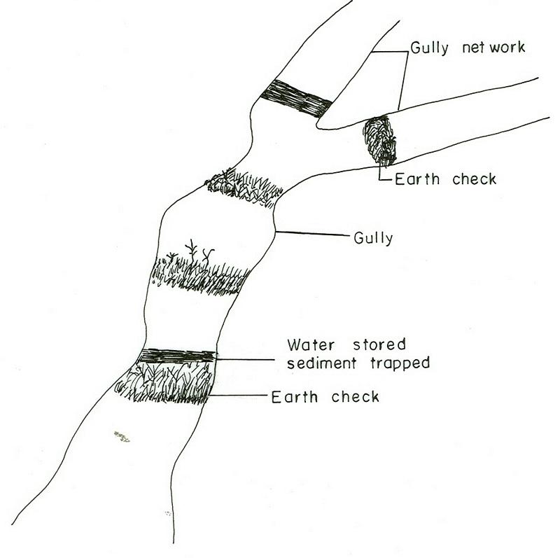
Earh-checks are constructed of earth embankment put across in a deep gully in such a way to trap sediment and store water passing by it.
2.2 Description détaillée de la Technologie
Description:
Active deep gullies are plugged by digging earth from the bottom as well as gully sides and embanked forming a barrier to runoff passing through it. The embankment is reinforced by planting useful plants such as banana, sesbania, gravillea, gesho, etc., The purpose is to rehabilitate gullies having depth and expand along sides and towards the head. By constructing earth checks the water is stored in the checks. The water percolates down the ground enriching the ground water. The soil is trapped in the checks and later brings up the gully gradient higher. As a result, a cultivable/cropable strip is formed. Weeding and cultivation done to plants established.The gully fence and breaks are repaired. The technology is seen to be suitable to humid highlands where land loss by gully is a serious problem and land under cultivation and grazing is getting here and there. In brief it is suitable in areas where land degradation problem is increasing with currently cultivated and grazed lands are encroched by gully expansion.
2.3 Photos de la Technologie
Galerie Médias
2.5 Pays/ région/ lieux où la Technologie a été appliquée et qui sont couverts par cette évaluation
Pays:
Ethiopie
Région/ Etat/ Province:
SNNPR
Autres spécifications du lieu:
SNNPR/Damot Galle/Bilate
Commentaires:
Total area covered by the SLM Technology is 51.2 km2.
Map
×2.6 Date de mise en œuvre de la Technologie
Si l'année précise est inconnue, indiquez la date approximative: :
- il y a moins de 10 ans (récemment)
2.7 Introduction de la Technologie
Spécifiez comment la Technologie a été introduite: :
- par le biais de projets/ d'interventions extérieures
Commentaires (type de projet, etc.) :
The technology is introduced but highly modified by adjesting design, layout and by increasing use of locally available materials for construction.
3. Classification de la Technologie de GDT
3.1 Principal(aux) objectif(s) de la Technologie
- réduire, prévenir, restaurer les terres dégradées
3.2 Type(s) actuel(s) d'utilisation des terres, là où la Technologie est appliquée
Les divers types d'utilisation des terres au sein du même unité de terrain: :
Oui
Précisez l'utilisation mixte des terres (cultures/ pâturages/ arbres):
- Agro-sylvo-pastoralisme

Terres cultivées
- Cultures annuelles
- Cultures pérennes (non ligneuses)
- Plantations d’arbres ou de buissons
Cultures annuelles - Précisez les cultures:
- céréales - maïs
- céréales - sorgho
- plantes à racines et à tubercules - patates douces, igname, taro, colocase, autres
- plantes à racines et à tubercules - manioc
- plantes à racines et à tubercules - pommes de terre
Plantations d'arbres et d'arbustes - Précisez les cultures:
- avocat
- fruits, autres
- manguier, mangostane, goyave
- papaye
- enset, taro, sugar cane, Leucaena, Sesbania, Grevillea
Nombre de période de croissance par an: :
- 2
Précisez:
Longest growing period in days: 210 Longest growing period from month to month: Apr - Oct Second longest growing period in days: 180 Second longest growing period from month to month: Aug - Jun
Est-ce que les cultures intercalaires sont pratiquées?
Oui
Si oui, précisez quelles cultures sont produites en culture intercalaire:
maize-sweet potato/haricot bean
Est-ce que la rotation des cultures est appliquée?
Oui
Si oui, veuillez préciser:
maize-tarro-sorghum

Pâturages
Type d'animal:
- bétail - laitier
- chevaux
- donkeys, oxen

Forêts/ bois
Produits et services:
- Bois d'œuvre (de construction)
- Bois de chauffage
- Pâturage/ broutage
Commentaires:
Major land use problems (compiler’s opinion): Monocropping, soil erosion, fertility mining, overgrazing, improper runoff management.
Grazingland comments: Livestock such as cows, oxen, donkeys and horse are thethered at a very small piece of land left infront of houses usually meant for social purposes. Some farmers thether their animals in a piece of land left uncropped in the field. The most part of livestock feed comes from crop residue which is collected from crop fields. Maize stalk, teff straw and enset leaves are fed stall.
Forest products and services: timber, fuelwood, grazing / browsing
Type of cropping system and major crops comments: Maize-sweet potato-Teff-potato-sorghum
3.4 Approvisionnement en eau
Approvisionnement en eau des terres sur lesquelles est appliquée la Technologie:
- pluvial
3.5 Groupe de GDT auquel appartient la Technologie
- mesures en travers de la pente
- récupération/ collecte de l'eau
3.6 Mesures de GDT constituant la Technologie
3.7 Principaux types de dégradation des terres traités par la Technologie

érosion hydrique des sols
- Wt: perte de la couche superficielle des sols (couche arable)/ érosion de surface
- Wg: ravinement/ érosion en ravines

dégradation chimique des sols
- Cn: baisse de la fertilité des sols et réduction du niveau de matière organique (non causée par l’érosion)
Commentaires:
Main type of degradation addressed: Wt: loss of topsoil / surface erosion, Wg: gully erosion / gullying
Secondary types of degradation addressed: Cn: fertility decline and reduced organic matter content
3.8 Prévention, réduction de la dégradation ou réhabilitation des terres dégradées
Spécifiez l'objectif de la Technologie au regard de la dégradation des terres:
- prévenir la dégradation des terres
- réduire la dégradation des terres
Commentaires:
Main goals: Also rehabilitation / reclamation of denuded land
4. Spécifications techniques, activités, intrants et coûts de mise en œuvre
4.1 Dessin technique de la Technologie
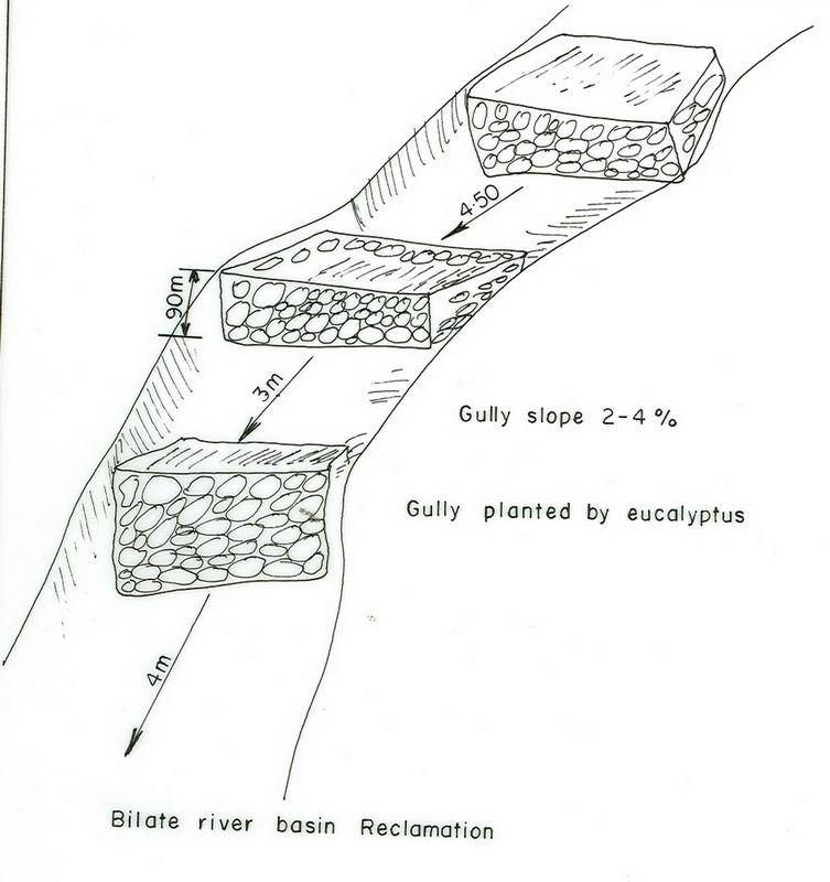
Spécifications techniques (associées au dessin technique):
SNNPR
Technical knowledge required for field staff / advisors: high
Technical knowledge required for land users: moderate
Main technical functions: water harvesting / increase water supply, sediment retention / trapping, sediment harvesting
Secondary technical functions: control of concentrated runoff: retain / trap, reduction of slope angle, reduction of slope length
Early planting
Material/ species: maize
Quantity/ density: 85000/ha
Remarks: sawn in lines
Mixed cropping / intercropping
Material/ species: maize-sweet potato/haricot bean
Remarks: inter cropped & strip cropped
Contour planting / strip cropping
Material/ species: maize-taro-enset
Mulching
Material/ species: enset
Manure / compost / residues
Material/ species: maize, potato, sweet potato, traro
Mineral (inorganic) fertilizers
Material/ species: Teff, maize, sorghum
Rotations / fallows
Material/ species: maize-tarro-sorghum
Remarks: only rotations
Breaking compacted topsoil
Remarks: primary and secondary oxen tillage
Contour tillage
Remarks: tillage done following contour
Agronomic measure: harrowing
Aligned: -contour
Vegetative material: O : other
Vertical interval between rows / strips / blocks (m): 0.2-0.5
Spacing between rows / strips / blocks (m): 2-4
Vertical interval within rows / strips / blocks (m): 0.5-2
Width within rows / strips / blocks (m): 0.5-1
Scattered / dispersed
Vegetative material: T : trees / shrubs
Number of plants per (ha): 4000
Vertical interval between rows / strips / blocks (m): 0.2
Spacing between rows / strips / blocks (m): 1.5x1.5
Vertical interval within rows / strips / blocks (m): 1.5
Width within rows / strips / blocks (m): 1.5
In blocks
Vegetative material: T : trees / shrubs
Number of plants per (ha): 2500
Vertical interval between rows / strips / blocks (m): 0.5
Spacing between rows / strips / blocks (m): 2x2
Vertical interval within rows / strips / blocks (m): 2
Width within rows / strips / blocks (m): 2
Trees/ shrubs species: Leucaena, Sesbania, Grevillea
Fruit trees / shrubs species: Mango, papaya, Avocado
Perennial crops species: Casava
Slope (which determines the spacing indicated above): 10.00%
If the original slope has changed as a result of the Technology, the slope today is (see figure below): 8.00%
Gradient along the rows / strips: 0.00%
Diversion ditch/ drainage
Depth of ditches/pits/dams (m): 0.5
Width of ditches/pits/dams (m): 0.5
Length of ditches/pits/dams (m): 100
Height of bunds/banks/others (m): 0.6
Width of bunds/banks/others (m): 0.5
Length of bunds/banks/others (m): 100
Retention/infiltration ditch/pit, sediment/sand trap
Vertical interval between structures (m): 0.5
Depth of ditches/pits/dams (m): 0.6
Width of ditches/pits/dams (m): 0.7
Length of ditches/pits/dams (m): 4
Height of bunds/banks/others (m): 0.75
Width of bunds/banks/others (m): 0.6
Terrace: backward sloping
Vertical interval between structures (m): 1.5
Spacing between structures (m): 12
Depth of ditches/pits/dams (m): 0.9
Width of ditches/pits/dams (m): 0.5
Length of ditches/pits/dams (m): 50-75
Bund/ bank: level
Vertical interval between structures (m): 1.2
Spacing between structures (m): 10
Depth of ditches/pits/dams (m): 0.6
Width of ditches/pits/dams (m): 0.7
Length of ditches/pits/dams (m): 50-80
Height of bunds/banks/others (m): 0.75
Construction material (earth): Most of the structural measures are made by earth involving excavation and embankment.
Construction material (stone): Stone is mainly used for demonstration.
Slope (which determines the spacing indicated above): 10%
If the original slope has changed as a result of the Technology, the slope today is: 8%
Lateral gradient along the structure: 0%
Vegetation is used for stabilisation of structures.
Change of land use type: The land after treatment is closed
Control / change of species composition: Grazing land changed to plantation and cropping
Other type of management: change of management / intensity level - Grazing land changed to plantation and cropping
4.2 Informations générales sur le calcul des intrants et des coûts
autre/ monnaie nationale (précisez):
Birr
Indiquez le taux de change des USD en devise locale, le cas échéant (p.ex. 1 USD = 79.9 réal brésilien): 1 USD = :
8,5
Indiquez le coût salarial moyen de la main d'œuvre par jour:
0.60
4.3 Activités de mise en place/ d'établissement
| Activité | Calendrier des activités (saisonnier) | |
|---|---|---|
| 1. | Land preparation | September, october |
| 2. | Sugar cane planting | November |
| 3. | Sugar cane cultivation | January/August |
| 4. | Casava planting | April |
| 5. | Casava cultivation | June |
| 6. | Maize planting | January-1st plough, April 2nd plough |
| 7. | Maize cultivation | June |
| 8. | Sweet potato planting | September |
| 9. | Sweet potato cultivation | October |
| 10. | Fruite trees | June |
| 11. | Digging foundation | November-February |
| 12. | Forming embankment | November-February |
| 13. | Side wall shaping | November-February |
| 14. | Planting trees and shrubs | March-1st planting & June 2nd planting |
| 15. | Excluding animals by fencing and guarding | all year |
| 16. | Construct cutoff drain | dry season |
| 17. | Establish buffer zone between Area enclosure and crop land by strip of plantation | June/July |
| 18. | Construct earth checks and trenches in the gully | dry season |
4.4 Coûts et intrants nécessaires à la mise en place
| Spécifiez les intrants | Unité | Quantité | Coûts par unité | Coût total par intrant | % du coût supporté par les exploitants des terres | |
|---|---|---|---|---|---|---|
| Main d'œuvre | Labour | ha | 1,0 | 282,3 | 282,3 | 100,0 |
| Equipements | Tools | ha | 1,0 | 270,6 | 270,6 | 100,0 |
| Matériel végétal | Seedlings | ha | 1,0 | 117,6 | 117,6 | 100,0 |
| Coût total de mise en place de la Technologie | 670,5 | |||||
| Coût total de mise en place de la Technologie en dollars américains (USD) | 78,88 | |||||
Commentaires:
Duration of establishment phase: 24 month(s)
4.5 Activités d'entretien/ récurrentes
| Activité | Calendrier/ fréquence | |
|---|---|---|
| 1. | Land preparation | september, october / 2 times |
| 2. | Sweet potato planting | September / each cropping season |
| 3. | Sweet potato cultivation | October / each cropping season |
| 4. | Maize planting | January/April / each cropping season |
| 5. | Maize cultivation | June / each cropping season |
| 6. | Teff sawing | |
| 7. | Teff weeding | |
| 8. | Prunning | october /once |
| 9. | Mulching | october /once |
| 10. | Thining | october /once |
| 11. | Fencing | any time /once |
| 12. | Weeding | June/each cropping season |
| 13. | Cultivation | March/each cropping season |
| 14. | Replanting | June/each cropping season |
| 15. | Repair in breaks | November-February/each cropping season |
| 16. | Fence | each cropping season |
| 17. | Repair breaks on cutoff drain and earth checks | dry season / 2 years |
| 18. | Prunning, weeding and cultivation | end of rains / each cropping season |
4.6 Coûts et intrants nécessaires aux activités d'entretien/ récurrentes (par an)
Commentaires:
Machinery/ tools: spade, hoe
Length and width of structure
4.7 Facteurs les plus importants affectant les coûts
Décrivez les facteurs les plus importants affectant les coûts :
Factors affecting costs in this technology are the depth and width of gully, steepness of slope, planting and replanting of vegetative materials.
5. Environnement naturel et humain
5.1 Climat
Précipitations annuelles
- < 250 mm
- 251-500 mm
- 501-750 mm
- 751-1000 mm
- 1001-1500 mm
- 1501-2000 mm
- 2001-3000 mm
- 3001-4000 mm
- > 4000 mm
Zone agro-climatique
- subhumide
5.2 Topographie
Pentes moyennes:
- plat (0-2 %)
- faible (3-5%)
- modéré (6-10%)
- onduleux (11-15%)
- vallonné (16-30%)
- raide (31-60%)
- très raide (>60%)
Reliefs:
- plateaux/ plaines
- crêtes
- flancs/ pentes de montagne
- flancs/ pentes de colline
- piémonts/ glacis (bas de pente)
- fonds de vallée/bas-fonds
Zones altitudinales:
- 0-100 m
- 101-500 m
- 501-1000 m
- 1001-1500 m
- 1501-2000 m
- 2001-2500 m
- 2501-3000 m
- 3001-4000 m
- > 4000 m
Commentaires et précisions supplémentaires sur la topographie:
Slopes on average: Moderate (ranked 1, about 70%), gentle and rolling (both ranked 2) and flat (ranked 3)
5.3 Sols
Profondeur moyenne du sol:
- très superficiel (0-20 cm)
- superficiel (21-50 cm)
- modérément profond (51-80 cm)
- profond (81-120 cm)
- très profond (>120 cm)
Texture du sol (de la couche arable):
- moyen (limoneux)
Matière organique de la couche arable:
- moyen (1-3%)
Si disponible, joignez une description complète du sol ou précisez les informations disponibles, par ex., type de sol, pH/ acidité du sol, capacité d'échange cationique, azote, salinité, etc.
Soil depth on average: Deep (Soils are very deep (75%))
Soil texture: Medium (fertile loam soils)
Soil fertility is medium (ranked 1) and high (ranked 2)
Topsoil organic matter: Medium (ranked 1, in the crop lands), low (ranked 2, degraded areas) and high (ranked 3, around the homestead)
Soil water storage capacity: Medium (ranked 1, on crop land) and high (ranked 2, on flat plateau land)
5.6 Caractéristiques des exploitants des terres appliquant la Technologie
Orientation du système de production:
- subsistance (auto-approvisionnement)
- exploitation mixte (de subsistance/ commerciale)
Revenus hors exploitation:
- 10-50% de tous les revenus
Niveau relatif de richesse:
- moyen
Niveau de mécanisation:
- travail manuel
- traction animale
Indiquez toute autre caractéristique pertinente des exploitants des terres:
Population density: > 500 persons/km2
Annual population growth: 2% - 3%
5% of the land users are rich.
10% of the land users are average wealthy.
45% of the land users are poor.
40% of the land users are poor.
Off-farm income specification: Farmers who have SWC measures on their land produce more and hence have better financial income, which could allow them get involved in petty trade and other activities.
Level of mechanization: Animal traction (ranked 1, crop lands) and manual work ( ranked 2, homstead and gully lands)
Market orientation of cropland production system: subsistence (self-supply, maize) and mixed (subsistence/ commercial, sweet potato, teff, coffee)
5.7 Superficie moyenne des terres utilisées par les exploitants des terres appliquant la Technologie
- < 0,5 ha
- 0,5-1 ha
- 1-2 ha
- 2-5 ha
- 5-15 ha
- 15-50 ha
- 50-100 ha
- 100-500 ha
- 500-1 000 ha
- 1 000-10 000 ha
- > 10 000 ha
Commentaires:
Cropland: 0.5-1 ha (more than 80% of farmers) and 1-2 ha
grazing land: 0.5-1 ha (communal grazing lands are severly degraded)
6. Impacts et conclusions
6.1 Impacts sur site que la Technologie a montrés
Impacts socio-économiques
Production
production agricole
production fourragère
qualité des fourrages
surface de production
Commentaires/ spécifiez:
Shortage of grazing land: Animals are thethered in a small plots
Revenus et coûts
revenus agricoles
Impacts socioculturels
institutions communautaires
Commentaires/ spécifiez:
teams are formed
institutions nationales
connaissances sur la GDT/ dégradation des terres
apaisement des conflits
Commentaires/ spécifiez:
many wants to be beneficiaries but only the poor given the opportunities
Impacts écologiques
Sols
humidité du sol
couverture du sol
perte en sol
Autres impacts écologiques
Biodiversity enhancement
6.2 Impacts hors site que la Technologie a montrés
inondations en aval
Commentaires/ spécifiez:
all runoff retained
envasement en aval
Commentaires/ spécifiez:
all soil trapped
6.4 Analyse coûts-bénéfices
Quels sont les bénéfices comparativement aux coûts de mise en place (du point de vue des exploitants des terres)?
Rentabilité à court terme:
légèrement positive
Rentabilité à long terme:
positive
Quels sont les bénéfices comparativement aux coûts d'entretien récurrents (du point de vue des exploitants des terres)?
Rentabilité à court terme:
positive
Rentabilité à long terme:
positive
6.5 Adoption de la Technologie
Commentaires:
50 land user families have adopted the Technology with external material support
7. Références et liens
7.1 Méthodes/ sources d'information
Liens et modules
Développer tout Réduire toutLiens
Aucun lien
Modules
Aucun module trouvé