Rangeland Improvement in Savanah with High Livestocks [Tanzanie]
- Création :
- Mise à jour :
- Compilateur : Jasson Rwazo
- Rédacteur : –
- Examinateurs : Deborah Niggli, Alexandra Gavilano
Uboreshaji wa Nyanda za malisho katika uoto wa asili wa savana wenye ng'ombe wengi.
technologies_1314 - Tanzanie
Voir les sections
Développer tout Réduire tout1. Informations générales
1.2 Coordonnées des personnes-ressources et des institutions impliquées dans l'évaluation et la documentation de la Technologie
Spécialiste GDT:
Poder Alexander
Nom du ou des institutions qui ont facilité la documentation/ l'évaluation de la Technologie (si pertinent)
Missenyi District Council (Missenyi District Council) - Tanzanie1.3 Conditions relatives à l'utilisation par WOCAT des données documentées
Le compilateur et la(les) personne(s) ressource(s) acceptent les conditions relatives à l'utilisation par WOCAT des données documentées:
Oui
1.4 Déclaration sur la durabilité de la Technologie décrite
Est-ce que la Technologie décrite ici pose problème par rapport à la dégradation des terres, de telle sorte qu'elle ne peut pas être déclarée comme étant une technologie de gestion durable des terres?
Non
2. Description de la Technologie de GDT
2.1 Courte description de la Technologie
Définition de la Technologie:
Improvement of degraded rangeland in savannah using multiple rangeland improvement techniques that complement each other to optimize livestock production and productivity sustainably.
2.2 Description détaillée de la Technologie
Description:
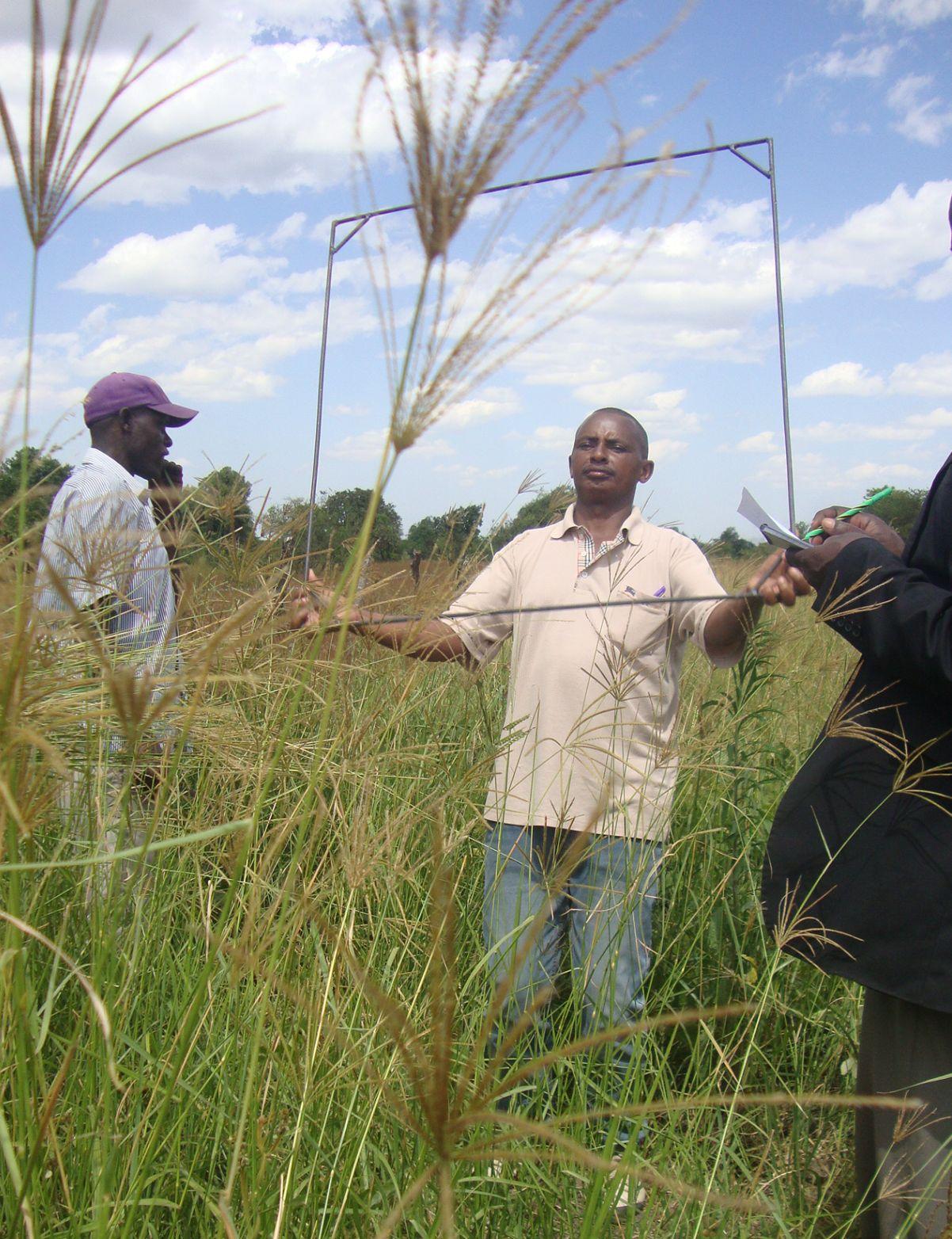
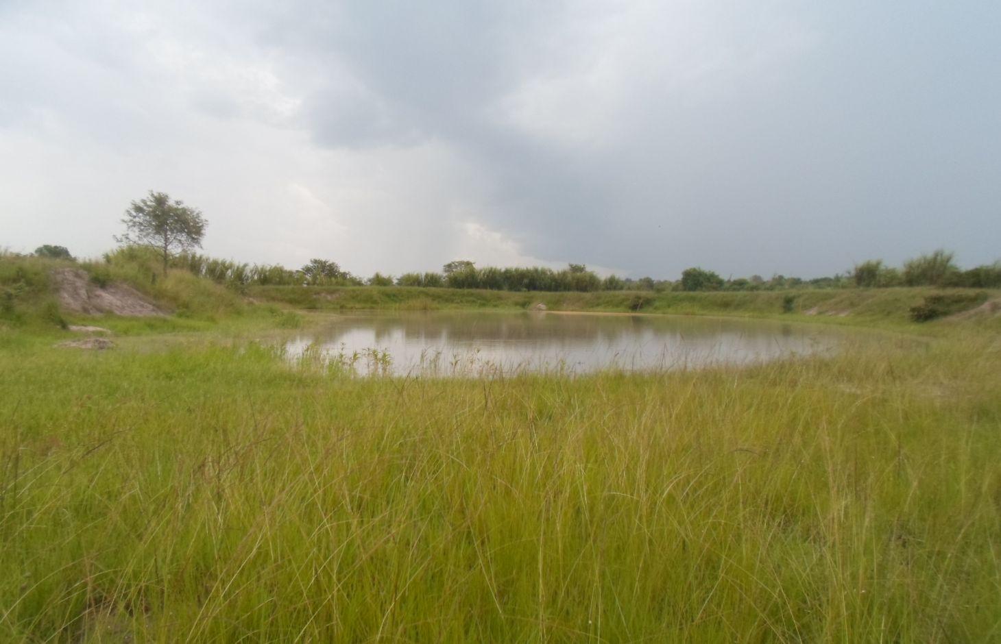
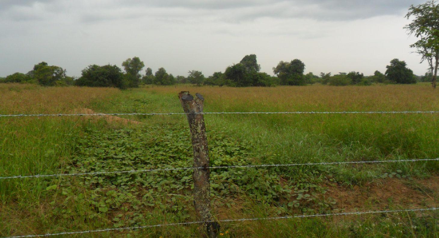
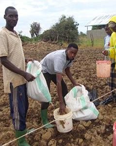
Multiple rangeland and pasture improvement techniques that combines water harvesting, rangeland reseeding and pasture establishment, livestock breeding management techniques to restore degraded rangeland in savannah with high livestock and optimize livestock production and productivity sustainably. These includes; 1. Chaco dam excavation for rain runoff harvesting mainly during the rainy season (February to April and August to December) mostly;(i).To ensure year round availability of water largely for watering livestock and partly for domestic and agriculture use especially during the main dry season when local sources (Ponds, springs or stream) are dry,(ii).To reduce soil erosion by water (lily or gully erosion, (iii).To reduce river bank erosion and silitation due direct watering of livestock in to Kagera river, (iii). To reduce the distance animal has to walk for watering and (iv) to reduce water use conflicts between herders and other land users. 2. Establishment of pasture demonstration plots where farmers are exposed to a basket choice (Low cost technique Vs high cost technique) of pasture and rangeland improvement technique either through ;( a). Tilling the land and broadcasting drought tolerant indigenous degenerated palatable pasture species of high nutritive value and, mainly (i).Grass; Cenchrus cliaris, Chloris gayana and (ii).Legumes; Centrocema puberse, Lablab purpureus, Mucuna Pluriens and Puperaria Phaseilides ) to a manured degraded rangeland; (b).i. Encouraging re-growth of proper pasture species in a degraded area to take place through clearing bushes, shrubs or trees ( leaving edible shrubs and few selected shed trees especially acacia spp which allow pasture re-growth underneath and provide shed against intense sun radiations to livestock especially during the main dry season- July to September); ii. Closing the degraded area by fencing using live indigenous trees or using wooden pole with or without barbed wire for 2 -3 years, removal of anthills and discouraging regeneration of unproductive invasive species and hence returning the rangeland to productivity;3. Genetical improvement of local cattle (Ankole or Zebu) through crossbreeding with introduced improved bull especially boran, Frisian or Mpwapwa bulls to allow farmers to keep few improved offspring of high production and productivity ;4.Farmer training on rangeland improvement and grazing management including hay making and how to estimate carrying capacity 5. Establishment of livestock markets directly on the rangeland to encourage off take and hence control stocking rate and increase carrying capacity.
Purpose:To contribute to the increase of herders’ standard of living through increased livestock production and productivity while conserving the environment
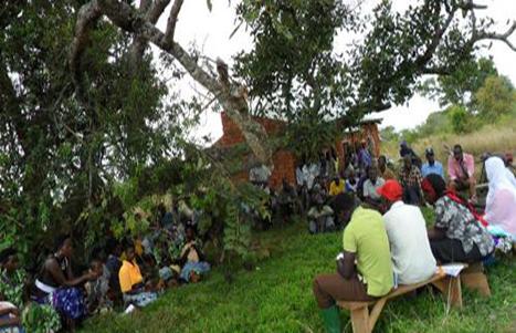
Estblishment activities:1. Community mobilization and formation of project management commetee with 10 members; 2. Identification of project sites; 3. Land clearing; 4. Establishment of pasture demonstration plots; 5. Excavation of chacodam and construction of watering troughs; 6. Fencing of individual owned land using wooden pole with barbed wire or live fencing using euphobia spp; 7. Farmer training on pasture establishment and controll of stocking rate; 8. Procurement of bulls (Boran or Mpwapwa) for cross breeding with ankole females; 9. Construction of livestock market
Maintanence Activities: 1. Repair of livestock infrastructures (Chacodam, watering troughs, livestock fence, livestock markets).
The technology is implemented in extensive grazing land under semi arid condition receiving 600 -1000mm of rains per year. A combination of rangeland improvement measures (Excavation of chacodam for rainwater runoff harvesting, pasture improvement and establishment techniques, fencing and breeding management through cross breeding local cow (Ankole/zebu) with Boran/Mpwapwa bulls) complement each other to restore degraded rangeland and increase livestock production and productivity in savannah. The slope is gentle to moderate; soil depth is shallow and soil texture clay. Heavy tools (Bulldozer) to Simple hand tools are traditional used. Bulldozers are used during chacodam excavation and bush clearing by well-off herder will small hand tools such as hand hoe, bush knife and spade are used smallholder herders for excavation of water pond and construction of indigenous livestock watering points. Land ownership is Communal/village, individual titled and individual not titled. Water use rights is open access (unorganized), communal (organized). Application of this technology determined by high establishment costs.
2.3 Photos de la Technologie
Galerie Médias
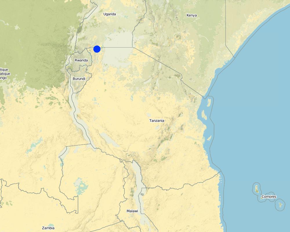
2.5 Pays/ région/ lieux où la Technologie a été appliquée et qui sont couverts par cette évaluation
Pays:
Tanzanie
Région/ Etat/ Province:
Kagera
Autres spécifications du lieu:
Missenyi, Tanzania
Spécifiez la diffusion de la Technologie:
- répartie uniformément sur une zone
S'il n'existe pas d'informations exactes sur la superficie, indiquez les limites approximatives de la zone couverte:
- 1-10 km2
Map
×2.6 Date de mise en œuvre de la Technologie
Si l'année précise est inconnue, indiquez la date approximative: :
- il y a moins de 10 ans (récemment)
2.7 Introduction de la Technologie
Spécifiez comment la Technologie a été introduite: :
- par le biais de projets/ d'interventions extérieures
3. Classification de la Technologie de GDT
3.1 Principal(aux) objectif(s) de la Technologie
- améliorer la production
- réduire, prévenir, restaurer les terres dégradées
3.2 Type(s) actuel(s) d'utilisation des terres, là où la Technologie est appliquée

Terres cultivées
- Plantations d’arbres ou de buissons

Pâturages
Pâturage extensif:
- Pastoralisme de type semi-nomade
Type d'animal:
- bétail - non laitier, utilisé pour le travail
- Ankole, Zebu
Commentaires:
Livestock density (if relevant):
> 100 LU /km2
Major land use problems (compiler’s opinion): Major land use problem without conservation includes, overgrazing, soil erosion, siltation of water bodies (Kagera River) and loss of paratable pasture spp.
Major land use problems (land users’ perception): Shortage of pasture and water for livestock
3.3 Est-ce que l’utilisation des terres a changé en raison de la mise en œuvre de la Technologie ?
Pâturages
Pâturage extensif:
- Pastoralisme de type semi-nomade
Commentaires:
Grazing land: Extensive grazing land
3.4 Approvisionnement en eau
Approvisionnement en eau des terres sur lesquelles est appliquée la Technologie:
- pluvial
Commentaires:
Number of growing seasons per year:
2
3.5 Groupe de GDT auquel appartient la Technologie
- pastoralisme et gestion des pâturages
3.6 Mesures de GDT constituant la Technologie

pratiques agronomiques
- A1: Couverture végétale/ du sol
- A7: Autres

pratiques végétales
- V3: Défrichement de la végétation
- V5: Autres

structures physiques
- S5: Barrages/retenues, micro-bassins, étangs

modes de gestion
- M1: Changement du type d’utilisation des terres
- M2: Changement du niveau de gestion / d'intensification
- M5: Contrôle/ changement de la composition des espèces
Commentaires:
Type of agronomic measures: legume inter-planting, manure / compost / residues
Type of vegetative measures: in blocks
3.7 Principaux types de dégradation des terres traités par la Technologie

érosion hydrique des sols
- Wg: ravinement/ érosion en ravines

érosion éolienne des sols
- Et: perte de la couche superficielle des sols (couche arable)

dégradation physique des sols
- Pc: compaction

dégradation biologique
- Bc: réduction de la couverture végétale
- Bq: baisse de la quantité/ biomasse
Commentaires:
Main causes of degradation: overgrazing (Overgrazing due overstocking due to illegal migration on livestock), change in temperature (increased average temperature from 20.9o to 21.5oC in the past 20 years), Heavy / extreme rainfall (intensity/amounts) (decreased average annual rainfall from 1000mm to 870mm in the past 20 years), droughts, land tenure (Lack of village land use plan), inputs and infrastructure: (roads, markets, distribution of water points, other, …)
Secondary causes of degradation: deforestation / removal of natural vegetation (incl. forest fires) (Uncontrolled bush fire set purposely to remove overgrown bushes), disturbance of water cycle (infiltration / runoff), change of seasonal rainfall, population pressure (In migration of people from neighbourig districts and countries), education, access to knowledge and support services
3.8 Prévention, réduction de la dégradation ou réhabilitation des terres dégradées
Spécifiez l'objectif de la Technologie au regard de la dégradation des terres:
- réduire la dégradation des terres
4. Spécifications techniques, activités, intrants et coûts de mise en œuvre
4.1 Dessin technique de la Technologie
Spécifications techniques (associées au dessin technique):
Location: Bubale Village. Missenyi District/Kagera
Technical knowledge required for field staff / advisors: high
Technical knowledge required for land users: high
Main technical functions: improvement of ground cover, increase in organic matter, water harvesting / increase water supply, promotion of vegetation species and varieties (quality, eg palatable fodder)
Secondary technical functions: control of raindrop splash, control of concentrated runoff: retain / trap, improvement of topsoil structure (compaction), stabilisation of soil (eg by tree roots against land slides), increase / maintain water stored in soil
Legume inter-planting
Remarks: Legumes are inter-planted with grass to increase the nutritive value of the pasture
Manure / compost / residues
Material/ species: Farmyard manure
Quantity/ density: 60t/Ha
In blocks
Vegetative material: G : grass, O : other
Grass species: Cenchrus cliaris, Chloris gayana, elephant grass,
Other species: Legumes:Centrocema puberse, Lablab purpureus, Mucuna Pluriens and Puperaria Phaseilides
Dam/ pan/ pond
Depth of ditches/pits/dams (m): 2.3
Width of ditches/pits/dams (m): 40
Length of ditches/pits/dams (m): 80
Height of bunds/banks/others (m): 6
Width of bunds/banks/others (m): 4
Length of bunds/banks/others (m): 240
Structural measure: Water trough
Depth of ditches/pits/dams (m): 2.5
Width of ditches/pits/dams (m): 1
Length of ditches/pits/dams (m): 21
Structural measure: Appron
Depth of ditches/pits/dams (m): 3
Width of ditches/pits/dams (m): 0.3
Length of ditches/pits/dams (m): 27
Construction material (earth): Clay soil
Construction material (concrete): concrete
Vegetation is used for stabilisation of structures.
Control / change of species composition: Crossbreeding local female cattle(Ankole or Zebu) with boran or mpwapwa bulls
Other type of management: Closing the degraded area by fencing using pole or live indigenous trees with or without barbed wire for 2 -3 years, removal of anthills and discouraging regeneration of unproductive invasive species.
Auteur:
Jasson Rwazo, P.O.BOX 38, Missenyi Tanzania,email: Wazo12375@yahoo.co.uk
4.2 Informations générales sur le calcul des intrants et des coûts
autre/ monnaie nationale (précisez):
Tanzanian Shilling
Indiquez le taux de change des USD en devise locale, le cas échéant (p.ex. 1 USD = 79.9 réal brésilien): 1 USD = :
2186,41
Indiquez le coût salarial moyen de la main d'œuvre par jour:
6.86
4.3 Activités de mise en place/ d'établissement
| Activité | Calendrier des activités (saisonnier) | |
|---|---|---|
| 1. | Procurement of 6 Boran/Mpwapwa bulls | |
| 2. | Transportation of bulls from Dodoma | |
| 3. | Vaccination against East Cost fever (ECF) | |
| 4. | Fencing | Procument Barbed wire |
| 5. | Excavation of water chaco dam | During the dry season |
| 6. | Fence construction | During the dry season |
| 7. | Construction of livestock market | |
| 8. | Land preparation | Eary June to september |
| 9. | Manure application | Mid september to early november |
| 10. | Planting | Early octobar |
4.4 Coûts et intrants nécessaires à la mise en place
| Spécifiez les intrants | Unité | Quantité | Coûts par unité | Coût total par intrant | % du coût supporté par les exploitants des terres | |
|---|---|---|---|---|---|---|
| Main d'œuvre | labour | ha | 1,0 | 810,93 | 810,93 | |
| Equipements | tools | ha | 1,0 | 34,0 | 34,0 | |
| Matériel végétal | seeds | ha | 1,0 | 1204,0 | 1204,0 | |
| Engrais et biocides | compost/manure | ha | 1,0 | 274,42 | 274,42 | 20,0 |
| Matériaux de construction | Chacodam Excavation | ha | 1,0 | 16007,0 | 16007,0 | 20,0 |
| Matériaux de construction | Const livestock makert | ha | 1,0 | 12577,0 | 12577,0 | 20,0 |
| Autre | Procument of 6 bulls | ha | 1,0 | 548,84 | 548,84 | 20,0 |
| Autre | Vaccination | ha | 1,0 | 54,88 | 54,88 | |
| Autre | Fencing | ha | 1,0 | 1957,7 | 1957,7 | |
| Coût total de mise en place de la Technologie | 33468,77 | |||||
| Coût total de mise en place de la Technologie en dollars américains (USD) | 15,31 | |||||
Commentaires:
Duration of establishment phase: 36 month(s)
4.5 Activités d'entretien/ récurrentes
| Activité | Calendrier/ fréquence | |
|---|---|---|
| 1. | Repair of the fence | Once per year |
| 2. | Weeding and bush thinning | 0nce per year |
| 3. | Construction of fire break | Once per year |
| 4. | Harvesting pasture seeds | Once per year |
4.6 Coûts et intrants nécessaires aux activités d'entretien/ récurrentes (par an)
| Spécifiez les intrants | Unité | Quantité | Coûts par unité | Coût total par intrant | % du coût supporté par les exploitants des terres | |
|---|---|---|---|---|---|---|
| Main d'œuvre | labour | ha | 1,0 | 205,34 | 205,34 | 20,0 |
| Equipements | tools | ha | 1,0 | 34,0 | 34,0 | |
| Coût total d'entretien de la Technologie | 239,34 | |||||
| Coût total d'entretien de la Technologie en dollars américains (USD) | 0,11 | |||||
Commentaires:
Machinery/ tools: Hand hoe, bush knife, Bulldozer, handhooe, spade, truck, Hand hoe, hamer, nails, woods
4.7 Facteurs les plus importants affectant les coûts
Décrivez les facteurs les plus importants affectant les coûts :
Excavation of chacodam, fencing and procurement of breeding bulls
5. Environnement naturel et humain
5.1 Climat
Précipitations annuelles
- < 250 mm
- 251-500 mm
- 501-750 mm
- 751-1000 mm
- 1001-1500 mm
- 1501-2000 mm
- 2001-3000 mm
- 3001-4000 mm
- > 4000 mm
Zone agro-climatique
- semi-aride
Thermal climate class: tropics
5.2 Topographie
Pentes moyennes:
- plat (0-2 %)
- faible (3-5%)
- modéré (6-10%)
- onduleux (11-15%)
- vallonné (16-30%)
- raide (31-60%)
- très raide (>60%)
Reliefs:
- plateaux/ plaines
- crêtes
- flancs/ pentes de montagne
- flancs/ pentes de colline
- piémonts/ glacis (bas de pente)
- fonds de vallée/bas-fonds
Zones altitudinales:
- 0-100 m
- 101-500 m
- 501-1000 m
- 1001-1500 m
- 1501-2000 m
- 2001-2500 m
- 2501-3000 m
- 3001-4000 m
- > 4000 m
5.3 Sols
Profondeur moyenne du sol:
- très superficiel (0-20 cm)
- superficiel (21-50 cm)
- modérément profond (51-80 cm)
- profond (81-120 cm)
- très profond (>120 cm)
Texture du sol (de la couche arable):
- fin/ lourd (argile)
Matière organique de la couche arable:
- moyen (1-3%)
5.4 Disponibilité et qualité de l'eau
Profondeur estimée de l’eau dans le sol:
> 50 m
Disponibilité de l’eau de surface:
moyenne
Qualité de l’eau (non traitée):
faiblement potable (traitement nécessaire)
5.5 Biodiversité
Diversité des espèces:
- moyenne
5.6 Caractéristiques des exploitants des terres appliquant la Technologie
Orientation du système de production:
- subsistance (auto-approvisionnement)
- commercial/ de marché
Revenus hors exploitation:
- moins de 10% de tous les revenus
Niveau relatif de richesse:
- riche
- très riche
Individus ou groupes:
- groupe/ communauté
Genre:
- hommes
Indiquez toute autre caractéristique pertinente des exploitants des terres:
Land users applying the Technology are mainly common / average land users
Population density: 10-50 persons/km2
5% of the land users are very rich and own 50% of the land.
35% of the land users are rich and own 25% of the land.
55% of the land users are average wealthy and own 10% of the land.
5.7 Superficie moyenne des terres utilisées par les exploitants des terres appliquant la Technologie
- < 0,5 ha
- 0,5-1 ha
- 1-2 ha
- 2-5 ha
- 5-15 ha
- 15-50 ha
- 50-100 ha
- 100-500 ha
- 500-1 000 ha
- 1 000-10 000 ha
- > 10 000 ha
Cette superficie est-elle considérée comme de petite, moyenne ou grande dimension (en se référant au contexte local)?
- petite dimension
5.8 Propriété foncière, droits d’utilisation des terres et de l'eau
Propriété foncière:
- communauté/ village
- individu, sans titre de propriété
5.9 Accès aux services et aux infrastructures
santé:
- pauvre
- modéré
- bonne
éducation:
- pauvre
- modéré
- bonne
assistance technique:
- pauvre
- modéré
- bonne
emploi (par ex. hors exploitation):
- pauvre
- modéré
- bonne
marchés:
- pauvre
- modéré
- bonne
énergie:
- pauvre
- modéré
- bonne
routes et transports:
- pauvre
- modéré
- bonne
eau potable et assainissement:
- pauvre
- modéré
- bonne
services financiers:
- pauvre
- modéré
- bonne
6. Impacts et conclusions
6.1 Impacts sur site que la Technologie a montrés
Impacts socio-économiques
Production
production agricole
production fourragère
qualité des fourrages
production animale
production de bois
Disponibilité et qualité de l'eau
disponibilité de l'eau potable
Revenus et coûts
revenus agricoles
Impacts socioculturels
sécurité alimentaire/ autosuffisance
situation sanitaire
institutions communautaires
connaissances sur la GDT/ dégradation des terres
apaisement des conflits
contribution to human well-being
Commentaires/ spécifiez:
Grazing management and conservation knowledge
Impacts écologiques
Cycle de l'eau/ ruissellement
quantité d'eau
récolte/ collecte de l'eau
Sols
couverture du sol
compaction du sol
Réduction des risques de catastrophe et des risques climatiques
risques d'incendies
6.2 Impacts hors site que la Technologie a montrés
disponibilité de l'eau
envasement en aval
dommages sur les champs voisins
6.3 Exposition et sensibilité de la Technologie aux changements progressifs et aux évènements extrêmes/catastrophes liés au climat (telles que perçues par les exploitants des terres)
Extrêmes climatiques (catastrophes)
Catastrophes météorologiques
| Comment la Technologie fait-elle face à cela? | |
|---|---|
| tempête de vent locale | bien |
Catastrophes climatiques
| Comment la Technologie fait-elle face à cela? | |
|---|---|
| sécheresse | bien |
Commentaires:
Construction of chaco dam for water harvesting during the wet season to be used during the dry season, planting drought tolerant pasture sp
6.4 Analyse coûts-bénéfices
Quels sont les bénéfices comparativement aux coûts de mise en place (du point de vue des exploitants des terres)?
Rentabilité à court terme:
légèrement positive
Rentabilité à long terme:
très positive
Quels sont les bénéfices comparativement aux coûts d'entretien récurrents (du point de vue des exploitants des terres)?
Rentabilité à court terme:
positive
Rentabilité à long terme:
très positive
6.5 Adoption de la Technologie
Commentaires:
50 land user families have adopted the Technology without any external material support
There is a strong trend towards spontaneous adoption of the Technology
6.7 Points forts/ avantages/ possibilités de la Technologie
| Points forts/ avantages/ possibilités du point de vue de l'exploitant des terres |
|---|
| Increased livestock production(Milk and Meat) |
| Increased farm income |
| Points forts/ avantages/ possibilités du point de vue du compilateur ou d'une autre personne ressource clé |
|---|
| Increased water availability for livestock and domestic use |
| Increased pasture availability for livestock |
| Increased conservation knowledge |
| Increased livestock production and productivity |
6.8 Faiblesses/ inconvénients/ risques de la Technologie et moyens de les surmonter
| Faiblesses/ inconvénients/ risques du point de vue du compilateur ou d'une autre personne ressource clé | Comment peuvent-ils être surmontés? |
|---|---|
| High fire risk | Strengthener fire control bylaw, control burning and use of fire break |
7. Références et liens
7.1 Méthodes/ sources d'information
- visites de terrain, enquêtes sur le terrain
- interviews/entretiens avec les exploitants des terres
Quand les données ont-elles été compilées (sur le terrain)?
04/12/2015
Liens et modules
Développer tout Réduire toutLiens
Aucun lien
Modules
Aucun module trouvé