Shelterbelts for farmland in sandy areas [Chine]
- Création :
- Mise à jour :
- Compilateur : Meili WEN
- Rédacteur : –
- Examinateurs : David Streiff, Deborah Niggli, Alexandra Gavilano
Farmland shelter belt
technologies_1366 - Chine
Voir les sections
Développer tout Réduire tout1. Informations générales
1.2 Coordonnées des personnes-ressources et des institutions impliquées dans l'évaluation et la documentation de la Technologie
Spécialiste GDT:
Wang Dogmei
Chine
Nom du projet qui a facilité la documentation/ l'évaluation de la Technologie (si pertinent)
Book project: where the land is greener - Case Studies and Analysis of Soil and Water Conservation Initiatives Worldwide (where the land is greener)Nom du ou des institutions qui ont facilité la documentation/ l'évaluation de la Technologie (si pertinent)
GEF/OP12 Gansu Project (GEF/OP12 Gansu Project) - Chine1.3 Conditions relatives à l'utilisation par WOCAT des données documentées
Le compilateur et la(les) personne(s) ressource(s) acceptent les conditions relatives à l'utilisation par WOCAT des données documentées:
Oui
1.5 Référence au(x) Questionnaires sur les Approches de GDT (documentées au moyen de WOCAT)
Shelter Belt [Chine]
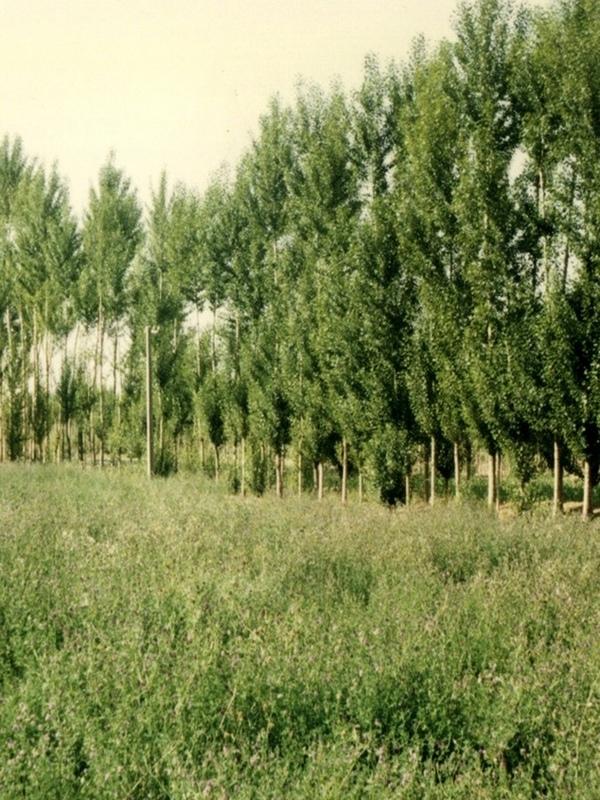
The shelter belt is a strip or a row of trees planted in a farmland as a wind barrier to protect crops and reduce wind erosion.
- Compilateur : Meili WEN
2. Description de la Technologie de GDT
2.1 Courte description de la Technologie
Définition de la Technologie:
Belts of trees, planted in a rectangular grid pattern or in strips within, and on the periphery of, farmland to act as windbreaks.
2.2 Description détaillée de la Technologie
Description:
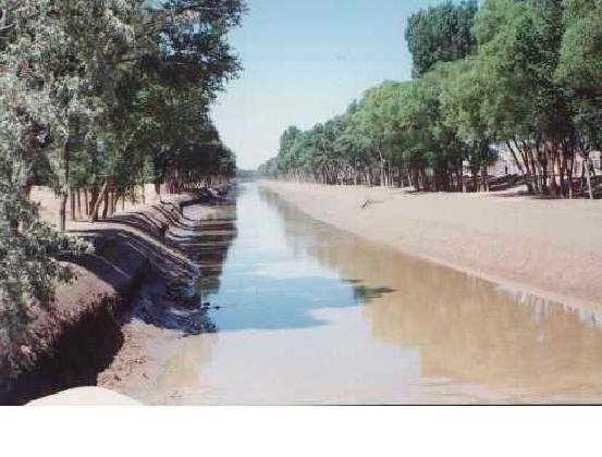
Shelterbelts to protect cropland are a specific type of agroforestry system comprising certain tall growing tree species. Such shelterbelts around farmland help reduce natural hazards including sandstorms, wind erosion, shifting sand, droughts and frost. They also improve the microclimate (reduced temperature, wind speed, soil water loss and excessive wind-induced transpiration) and create more favourable conditions for crop production. Thus the establishment of shelterbelts plays a crucial role in the sandy drylands that are affected by wind and resultant desertification
especially during winter and spring. Where there is irrigation, the shelterbelts protect the infrastructure from silting-up with wind-borne sediment.
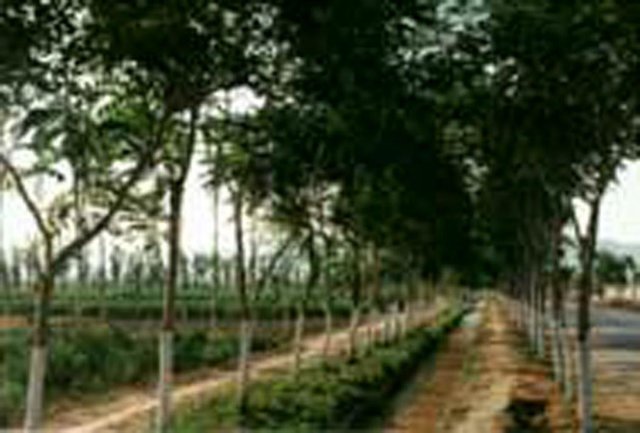
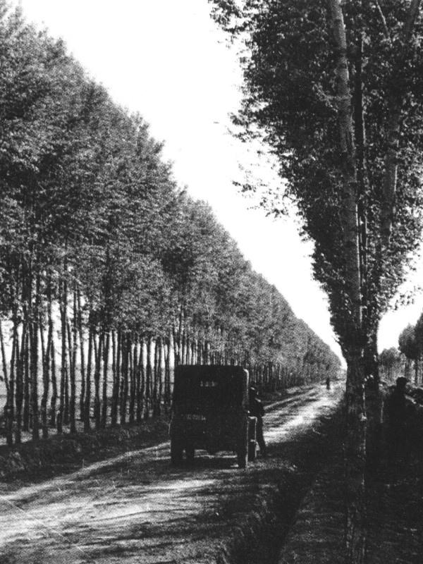
Strips of tall growing species (15-25 m) of poplar (Populus spp.) or willow (Salix spp.) were originally (from 1960s onwards) planted in a 400 by 600 m rectangular grid pattern within extensive areas of cropland, with an extra belt of windbreaks on the windward side (against the prevailing wind). Generally, the distance effectively protected is 15-25 times the tree height. Strips are of variable width, consisting of 2-5 tree lines (1-3 m apart) with trees planted every 1-2 m within the lines. Selective felling is used to maintain adequate growing space and the protective effect of the trees.
The impact of the shelterbelts depends on the planting pattern of the trees (the format of strips and grids), the orientation of the shelterbelts in relation to the wind, the spacing between, and the width of each strip and the type of trees planted. The specific design is primarily based on preventing the negative effects of wind, but depends also on local conditions such as the layout of the land, the location of the roads, farm boundaries and irrigation canals. Ideally the tree strips are perpendicular to the prevailing wind direction, and the angle between the strip and the prevailing wind is never less than 45 degrees. The structure of the strips determines the way the wind is controlled, ranging from blocking the wind
to letting it diffuse through semi-permeable shelterbelts. The best effect is achieved if the wind is not blocked entirely, as this can cause turbulence.
The ownership of the land and the shelterbelts still rests with the state, but management has been more and more transferred to individual households. On condition that the impact of the shelterbelt is not affected, the local forestry agencies now allow some felling of mature trees - on a rotational and selective basis, for timber and firewood. Pine trees (Pinus sylvestris var. mongolica and P. tabulaeformis), which command high value as timber for construction, and fruit (and cash) trees like the apricot tree (Prunus armeniace) are increasingly used.
2.3 Photos de la Technologie
Galerie Médias
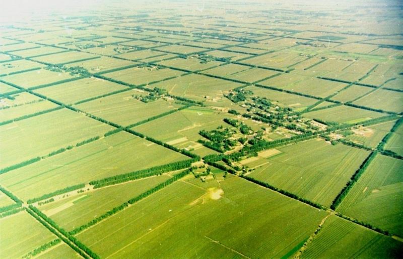
2.5 Pays/ région/ lieux où la Technologie a été appliquée et qui sont couverts par cette évaluation
Pays:
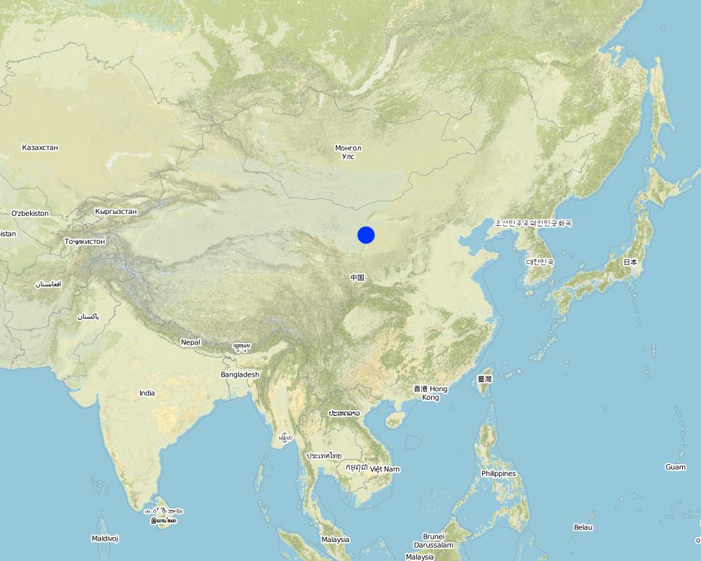
Chine
Région/ Etat/ Province:
Inner Mongolia Autonomous Region
Spécifiez la diffusion de la Technologie:
- répartie uniformément sur une zone
Si la Technologie est uniformément répartie sur une zone, précisez la superficie couverte (en km2):
500,0
S'il n'existe pas d'informations exactes sur la superficie, indiquez les limites approximatives de la zone couverte:
- 100-1 000 km2
Commentaires:
Total area covered by the SLM Technology is 500 km2.
Total SWC Technology area is not clear. This technology area data is from Inner Mongolia forest department. Inner Mongolia autonomy region forest statistic data, 1987, P75. Technology beginning year is from: Water and soil conservation bureau, Yellow River irrigation works committee of Department of water and electricity. Water and soil conservation economy benefit thesis collecting,1987, P45-47.
Map
×2.6 Date de mise en œuvre de la Technologie
Si l'année précise est inconnue, indiquez la date approximative: :
- il y a plus de 50 ans (technologie traditionnelle)
2.7 Introduction de la Technologie
Spécifiez comment la Technologie a été introduite: :
- par le biais de projets/ d'interventions extérieures
Commentaires (type de projet, etc.) :
USA and domestic.
3. Classification de la Technologie de GDT
3.1 Principal(aux) objectif(s) de la Technologie
- réduire les risques de catastrophes
- s'adapter au changement et aux extrêmes climatiques et à leurs impacts
3.2 Type(s) actuel(s) d'utilisation des terres, là où la Technologie est appliquée
Les divers types d'utilisation des terres au sein du même unité de terrain: :
Oui
Précisez l'utilisation mixte des terres (cultures/ pâturages/ arbres):
- Agroforesterie

Terres cultivées
- Cultures annuelles
Cultures annuelles - Précisez les cultures:
- céréales - maïs
- wheat
Nombre de période de croissance par an: :
- 1
Précisez:
Longest growing period in days: 150Longest growing period from month to month: May - Sep

Forêts/ bois
- Forêts (semi-)naturelles/ bois
- Plantations d'arbres, boisements
Forêts (semi-)naturelles/ terres boisées: précisez le mode de gestion:
- Coupes sélectives
Type d’arbres:
- Espèces de Pinus (pin)
- Espèces de Populus (peuplier)
- Salix spp
Produits et services:
- Bois d'œuvre (de construction)
- Bois de chauffage
- Fruits et noix
- Protection contre les aléas naturels
Commentaires:
Trees/ shrubs species: Poplars (Populus spp.), willows (Salix spp.), increasingly also pine (Pinus sylvestris var. Mongolic
Major land use problems (compiler’s opinion): Strong winds in the winter and spring result in serious natural hazards including sand storms, sand encroachment and wind erosion, while dry and hot winds in the summer increase transpiration leading to plant stress and reduced crop yields.
Major land use problems (land users’ perception): Low yield and intensive wind blow in winter and spring.
3.3 Est-ce que l’utilisation des terres a changé en raison de la mise en œuvre de la Technologie ?
Est-ce que l’utilisation des terres a changé en raison de la mise en œuvre de la Technologie ?
- Oui (Veuillez remplir les questions ci-après au regard de l’utilisation des terres avant la mise en œuvre de la Technologie)
Terres cultivées
- Cultures annuelles
3.4 Approvisionnement en eau
Approvisionnement en eau des terres sur lesquelles est appliquée la Technologie:
- mixte: pluvial-irrigué
3.5 Groupe de GDT auquel appartient la Technologie
- agroforesterie
- brise-vent/ plantations abris
3.6 Mesures de GDT constituant la Technologie

pratiques végétales
- V1: Couverture d’arbres et d’arbustes

modes de gestion
- M1: Changement du type d’utilisation des terres
Commentaires:
Main measures: vegetative measures
Type of vegetative measures: aligned: -against wind
3.7 Principaux types de dégradation des terres traités par la Technologie

érosion éolienne des sols
- Et: perte de la couche superficielle des sols (couche arable)
- Eo: effets hors site de la dégradation

dégradation hydrique
- Ha: aridification
Commentaires:
Main type of degradation addressed: Et: loss of topsoil, Eo: offsite degradation effects, Ha: aridification
Main causes of degradation: deforestation / removal of natural vegetation (incl. forest fires), poverty / wealth (Lack of captial)
Secondary causes of degradation: overgrazing, education, access to knowledge and support services (Lack of knowledge), Lack of enforcement of legislat./authority
3.8 Prévention, réduction de la dégradation ou réhabilitation des terres dégradées
Spécifiez l'objectif de la Technologie au regard de la dégradation des terres:
- réduire la dégradation des terres
Commentaires:
Main goals: mitigation / reduction of land degradation
4. Spécifications techniques, activités, intrants et coûts de mise en œuvre
4.1 Dessin technique de la Technologie
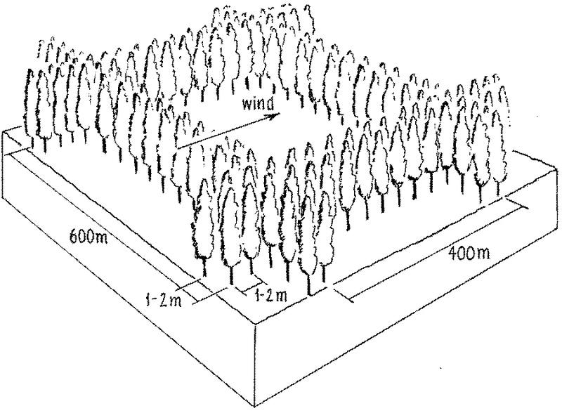
Spécifications techniques (associées au dessin technique):
Overview of the shelterbelt layout.
Insert 1: Planting scheme: shelterbelts compromise 2-5 tree lines forming the windbreak about 5-15 m wide and 15-25 m high.
Insert 2: Rectangle grid layout of shelterbelts. Spacing of the rows is denser against the prevailing wind.
Technical knowledge required for field staff / advisors: moderate
Technical knowledge required for land users: low
Main technical functions: increase / maintain water stored in soil, reduction in wind speed, protection from wind erosion, protection from sand encroachment, protection of crops from mechanical damage, reduction in evaporation loss
Secondary technical functions: increase in organic matter
Aligned: -against wind
Vegetative material: T : trees / shrubs
Trees/ shrubs species: Poplars (Populus spp.), willows (Salix spp.), increasingly also pine (Pinus sylvestris var. Mongolic)
Auteur:
Mats Gurtner
4.2 Informations générales sur le calcul des intrants et des coûts
Spécifiez la manière dont les coûts et les intrants ont été calculés:
- par superficie de la Technologie
Indiquez la taille et l'unité de surface:
ha
Indiquez la monnaie utilisée pour le calcul des coûts:
- dollars américains
Indiquez le coût salarial moyen de la main d'œuvre par jour:
1.20
4.3 Activités de mise en place/ d'établissement
| Activité | Calendrier des activités (saisonnier) | |
|---|---|---|
| 1. | 1 Planning / designing of shelterbelt. | |
| 2. | 2 Selection and collection of trees seedlings. | |
| 3. | 3 Clearing and preparing land for planting of shelterbelt in | late autumn and spring |
| 4. | 3 Clearing and preparing land for planting of shelterbelt in | |
| 5. | 4 Pits for planting the seedlings are dug | 4 Pits for planting the seedlings are dug |
| 6. | 5 Tree seedlings are planted | late spring |
| 7. | 6 After planting each seedling is watered for up to two years. |
4.4 Coûts et intrants nécessaires à la mise en place
| Spécifiez les intrants | Unité | Quantité | Coûts par unité | Coût total par intrant | % du coût supporté par les exploitants des terres | |
|---|---|---|---|---|---|---|
| Main d'œuvre | Mainly collection and planting | ha | 79,0 | 1,2 | 94,8 | |
| Equipements | tools | ha | 1,0 | 5,0 | 5,0 | 100,0 |
| Matériel végétal | tree seedlings | ha | 1,0 | 25,0 | 25,0 | |
| Coût total de mise en place de la Technologie | 124,8 | |||||
| Coût total de mise en place de la Technologie en dollars américains (USD) | 124,8 | |||||
Si le coût n'est pas pris en charge à 100% par l'exploitant des terres, indiquez qui a financé le coût restant:
USA and domestic projects
Commentaires:
Duration of establishment phase: 36 month(s)
4.5 Activités d'entretien/ récurrentes
| Activité | Calendrier/ fréquence | |
|---|---|---|
| 1. | Watering | after planting /timely |
| 2. | Pruning of trees. | |
| 3. | Pest and disease control within shelterbelt. | |
| 4. | Intermediate/ selective tree felling. |
4.6 Coûts et intrants nécessaires aux activités d'entretien/ récurrentes (par an)
| Spécifiez les intrants | Unité | Quantité | Coûts par unité | Coût total par intrant | % du coût supporté par les exploitants des terres | |
|---|---|---|---|---|---|---|
| Main d'œuvre | Watering and Pruning | ha | 7,0 | 1,2 | 8,4 | 100,0 |
| Matériel végétal | tree seedling | ha | 1,0 | 3,0 | 3,0 | 100,0 |
| Coût total d'entretien de la Technologie | 11,4 | |||||
| Coût total d'entretien de la Technologie en dollars américains (USD) | 11,4 | |||||
Commentaires:
The costs are calculated according to current standards/costs. The original planting is paid for by the state: replanting
and maintenance are the responsibility of the land user. If pines are the species of choice for re-planting, the cost
is considerably more than that shown above (which relates to poplar and willow).
Assuming: shelterbelts of 600 m by 400 m; each strip has 5 lines of trees (3 m apart), 2 m between trees within lines: resulting in 104 trees/ha, including the cropland between the strips (density within strips is 1666 trees/ha). Labour for establishment (104 trees): Land preparation, planting 10 days and 15 days for watering, weeding, etc (for first 3 years).
4.7 Facteurs les plus importants affectant les coûts
Décrivez les facteurs les plus importants affectant les coûts :
The most important factors to affect the costs are seedlings (No.) and machine.
5. Environnement naturel et humain
5.1 Climat
Précipitations annuelles
- < 250 mm
- 251-500 mm
- 501-750 mm
- 751-1000 mm
- 1001-1500 mm
- 1501-2000 mm
- 2001-3000 mm
- 3001-4000 mm
- > 4000 mm
Spécifiez la pluviométrie moyenne annuelle (si connue), en mm:
430,00
Zone agro-climatique
- semi-aride
5.2 Topographie
Pentes moyennes:
- plat (0-2 %)
- faible (3-5%)
- modéré (6-10%)
- onduleux (11-15%)
- vallonné (16-30%)
- raide (31-60%)
- très raide (>60%)
Reliefs:
- plateaux/ plaines
- crêtes
- flancs/ pentes de montagne
- flancs/ pentes de colline
- piémonts/ glacis (bas de pente)
- fonds de vallée/bas-fonds
Zones altitudinales:
- 0-100 m
- 101-500 m
- 501-1000 m
- 1001-1500 m
- 1501-2000 m
- 2001-2500 m
- 2501-3000 m
- 3001-4000 m
- > 4000 m
Indiquez si la Technologie est spécifiquement appliquée dans des:
- non pertinent
5.3 Sols
Profondeur moyenne du sol:
- très superficiel (0-20 cm)
- superficiel (21-50 cm)
- modérément profond (51-80 cm)
- profond (81-120 cm)
- très profond (>120 cm)
Texture du sol (de la couche arable):
- grossier/ léger (sablonneux)
Matière organique de la couche arable:
- moyen (1-3%)
Si disponible, joignez une description complète du sol ou précisez les informations disponibles, par ex., type de sol, pH/ acidité du sol, capacité d'échange cationique, azote, salinité, etc.
Soil fertility: low -medium
Soil drainage / infiltration: good
Soil water storage capacity: medium
5.6 Caractéristiques des exploitants des terres appliquant la Technologie
Orientation du système de production:
- exploitation mixte (de subsistance/ commerciale)
Revenus hors exploitation:
- 10-50% de tous les revenus
Niveau relatif de richesse:
- moyen
Niveau de mécanisation:
- mécanisé/ motorisé
Indiquez toute autre caractéristique pertinente des exploitants des terres:
Population density: 10-50 persons/km2
Annual population growth: 1% - 2%
80% of the land users are average wealthy and own 35% of the land.
Off-farm income specification: farmers benefit from the shelterbelts as a source of off-farm income, through fodder, timber and firewood
5.7 Superficie moyenne des terres utilisées par les exploitants des terres appliquant la Technologie
- < 0,5 ha
- 0,5-1 ha
- 1-2 ha
- 2-5 ha
- 5-15 ha
- 15-50 ha
- 50-100 ha
- 100-500 ha
- 500-1 000 ha
- 1 000-10 000 ha
- > 10 000 ha
5.8 Propriété foncière, droits d’utilisation des terres et de l'eau
- communal/state
- individual (see Annex T3 for remark)
- individual (see Annex T3 for remark)
6. Impacts et conclusions
6.1 Impacts sur site que la Technologie a montrés
Impacts socio-économiques
Production
production agricole
production de bois
surface de production
Commentaires/ spécifiez:
width of the shelterbelt
Revenus et coûts
revenus agricoles
Autres impacts socio-économiques
off-farm income
Commentaires/ spécifiez:
extra timber and firewood
Crop production
Commentaires/ spécifiez:
Trees in competition with crops for solar radiation, fertilizer, and water
Impacts socioculturels
apaisement des conflits
Loss of Food per agricultural land
Commentaires/ spécifiez:
shelterbelts of trees are not a direct source of food
Impacts écologiques
Cycle de l'eau/ ruissellement
ruissellement de surface
Quantité avant la GDT:
8
Quantité après la GDT:
0
Sols
humidité du sol
couverture du sol
perte en sol
Quantité avant la GDT:
4
Quantité après la GDT:
2
Réduction des risques de catastrophe et des risques climatiques
vitesse du vent
Autres impacts écologiques
sand encroachment
microclimate for crops
Commentaires/ spécifiez:
regulating temperature, increasing humidity
conservation/maintenance of soil fertility
6.4 Analyse coûts-bénéfices
Quels sont les bénéfices comparativement aux coûts d'entretien récurrents (du point de vue des exploitants des terres)?
Rentabilité à court terme:
légèrement positive
Rentabilité à long terme:
très positive
6.5 Adoption de la Technologie
- cas isolés/ expérimentaux
Si disponible, quantifiez (nombre de ménages et/ou superficie couverte):
40 households in an area of 100-1000km^2 (10-50 persons/km^2)
De tous ceux qui ont adopté la Technologie, combien d'entre eux l'ont fait spontanément, à savoir sans recevoir aucune incitation matérielle, ou aucune rémunération? :
- 0-10%
Commentaires:
100% of land user families have adopted the Technology with external material support
40 land user families have adopted the Technology with external material support
Comments on acceptance with external material support: estimates
Comments on spontaneous adoption: estimates
There is no trend towards spontaneous adoption of the Technology
Comments on adoption trend: The technology has not spontaneously spread beyond the areas developed through government intervention.
6.7 Points forts/ avantages/ possibilités de la Technologie
| Points forts/ avantages/ possibilités du point de vue du compilateur ou d'une autre personne ressource clé |
|---|
|
Reduced wind speed and trapped wind-blown sand particle How can they be sustained / enhanced? Combine deciduous and evergreen trees to maintain shelterbelt’s protective function throughtout the year. |
|
Increased crop yield How can they be sustained / enhanced? Extend shelterbelt technology to unprotected croplands. |
|
Increased cash income How can they be sustained / enhanced? Improve rotational felling regimes that maximise quantity and quality of tree products (timber; fruit etc) without reducing the shelterbelt’s protective function. In Inner Mongolia apricot (Prunus armeniaca) and sea buckthorn (Hippophae rhamnoides) and in Gansu Province the Chinese dates (Ziziphus jujuba) are increasingly used. |
|
Apart from their effect on the wind, the overall benefits of the shelterbelts - for timber, firewood, fruits and fodder for animals - outweigh the loss of cropland occupied by trees How can they be sustained / enhanced? Experience over 40 years has demonstrated that narrower trees strips and smaller grid size (100 by 200 m) would increase ecological efficiency, but due to higher costs and potential competition with crops, the spacing of the shelterbelts has mostly remained as it was originally. |
|
From 1960 onwards, approximately 22 million hectares – of vulnerable cropland have been protected in eastern Inner Mongolia Editors’ comments: In China, a total of 1.84 million km2 suffer from desertification related to sand storms, shifting sands and wind erosion, making up 19% of the total land area. In those dry and desertified zones, farmland is barely productive, even with irrigation. The construction of shelterbelts in this northeastern part of China has had multiple benefits that outweigh the loss of cropland. However, maintenance has become an important issue with the changes in China’s land use laws. This is one of two examples of windbreaks amongst the case studies in this book. Remark: In the 1960s, all land ownership and land use rights in China were communal and cropland was farmed collectively by village communes. After reform and open policy was put into practice in 1978, land use rights were transferred to the villages, to groups and individuals. Land itself and the shelterbelts however still belonged to the state. Nowadays the rights to cultivate specific parcels of land, within protected blocks, are generally granted to individual farm households. In some cases, in recent years, the shelterbelts too have been redistributed to individuals to look after. Inevitably maintenance has become an issue. But most of the shelterbelts are managed well. 3.2.8: If farmer cuts mature timber (for example a 40 year-old poplar), he/she can sell it for US$ 20–25 per tree. With maturity of shelterbelts, the timber production increases, which brings increasing economic benefits; meanwhile, the effect of protection from wind erosion also improves. |
6.8 Faiblesses/ inconvénients/ risques de la Technologie et moyens de les surmonter
| Faiblesses/ inconvénients/ risques du point de vue du compilateur ou d'une autre personne ressource clé | Comment peuvent-ils être surmontés? |
|---|---|
| Loss of land due to area used for the shelterbelts | In this wind-prone part of Inner Mongolia, overall gains from the protected zones compensate for the reduced area under crops, especially if economically valuable species are planted in the shelterbelt, such as Caragana korshinskii, which can be used as forage, for 'green fertilizer' through leaf mulch and for firewood. |
| Competition for sunshine, fertilizer and water | Pruning of branches and digging of ditches to prevent roots penetrating the adjacent cropland |
| Farmers lost the right to crop the tree-occupied land (since the shelterbelts belonged to the state). Originally, farmers were not allowed to fell trees | Nowadays the local forestry department permits farmers to occasionally cut trees, which is a source of income. If land users were allowed to cut trees on a more systematic basis, it would help them to better appreciate the benefits. |
| High cost (labour and money) for establishment | Government support required. |
|
Shelterbelts comprised of single tree species are less resistant to pests and diseases Shelterbelts consume more water |
Combine trees and shrubs/ different species, which improves both resistance and also the protective effect. But they also help in drainage (where this is a problem) through lowering the ground water table and simultaneously reducing salinity. Appropriate tree species need to be selected and bred. |
7. Références et liens
7.1 Méthodes/ sources d'information
7.2 Références des publications disponibles
Titre, auteur, année, ISBN:
China atlas. China atlas publishing house, P 52.. 1999.
Disponible à partir d'où? Coût?
library of Department of Resource and Environmental Science, BNU.
Titre, auteur, année, ISBN:
Zhao Yu, Jing Zhengping, Shi Peijun, Hao Yunchong et al. Inner Mongolia soil erosion research remote sensing was used in Inner Mongolia soil erosion research, Science publishing house, P25.. 1989.
Disponible à partir d'où? Coût?
library of Department of Resource and Environmental Science, BNU.
Titre, auteur, année, ISBN:
Inner Mongolia forest department, Forest work manual,12, P33-34, P67.. 1998.
Disponible à partir d'où? Coût?
library of Department of Resource and Environmental Science, BNU.
Titre, auteur, année, ISBN:
Synthesized investigate team in Inner Mongolia-Ningxia, CAS. West of northeast Forest in Inner Mongolia autonomy region, Science publishing house, P82-101.. 1981.
Disponible à partir d'où? Coût?
library of Department of Resource and Environmental Science, BNU.
Titre, auteur, année, ISBN:
Sun Jinzhu. Natural condition and reconstruct in Hetao plain, Inner Mongolia people' s publishing house, P188-189.. 1976.
Disponible à partir d'où? Coût?
library of Department of Resource and Environmental Science, BNU.
Titre, auteur, année, ISBN:
Inner Mongolia forest Department. Inner Mongolia autonomy region forest statistic data,P75.. 1987.
Disponible à partir d'où? Coût?
library of Department of Resource and Environmental Science, BNU.
Titre, auteur, année, ISBN:
Hu Chun(chief editor). Inner Mongolia autonomy region climate resources about agriculture, forest and animal husbandry, Inner Mongolia people's publishing house, P45-47.. 1984.
Disponible à partir d'où? Coût?
library of Department of Resource and Environmental Science, BNU.
Titre, auteur, année, ISBN:
Water and soil conservation bureau, Yellow River irrigation works committee of Department of water and electricity. Water and soil conservation economy benefit thesis collecting, P45-47.. 1987.
Disponible à partir d'où? Coût?
library of Department of Resource and Environmental Science, BNU.
Titre, auteur, année, ISBN:
Zhang Pangchuen, A study on the benefit of shelter belt in the south part of Kerqin sand to agriculture increase in production. Journal of arid land resource and environment. Vol.4, no.1, P11-87.. 1990.
Disponible à partir d'où? Coût?
library of Department of Resource and Environmental Science, BNU.
Titre, auteur, année, ISBN:
Sun Jinzhu,Chen Shan(chief editor). Inner Mongolia environment alarm beforehand and repair countermeasure. Inner Mongolia people's publishing house, P132.. 1994.
Disponible à partir d'où? Coût?
library of Department of Resource and Environmental Science, BNU.
Titre, auteur, année, ISBN:
Compilation Committee of Inner Mongolia Forest Inner Mongolia Forest, Beijing: China Forestry Publishing House, 1989,299–319. 1989.
Liens et modules
Développer tout Réduire toutLiens
Shelter Belt [Chine]
The shelter belt is a strip or a row of trees planted in a farmland as a wind barrier to protect crops and reduce wind erosion.
- Compilateur : Meili WEN
Modules
Aucun module trouvé