Trenches combined with living hedges or grass lines [Rwanda]
- Création :
- Mise à jour :
- Compilateur : Desire Kagabo
- Rédacteur : –
- Examinateur : David Streiff
Imiringoti
technologies_1550 - Rwanda
Voir les sections
Développer tout Réduire tout1. Informations générales
1.2 Coordonnées des personnes-ressources et des institutions impliquées dans l'évaluation et la documentation de la Technologie
Spécialiste GDT:
Spécialiste GDT:
Nom du projet qui a facilité la documentation/ l'évaluation de la Technologie (si pertinent)
The Transboundary Agro-ecosystem Management Project for the Kagera River Basin (GEF-FAO / Kagera TAMP )Nom du ou des institutions qui ont facilité la documentation/ l'évaluation de la Technologie (si pertinent)
FAO Food and Agriculture Organization (FAO Food and Agriculture Organization) - ItalieNom du ou des institutions qui ont facilité la documentation/ l'évaluation de la Technologie (si pertinent)
Rwanda Agriculture Board (Rwanda Agriculture Board) - Rwanda1.3 Conditions relatives à l'utilisation par WOCAT des données documentées
Le compilateur et la(les) personne(s) ressource(s) acceptent les conditions relatives à l'utilisation par WOCAT des données documentées:
Oui
2. Description de la Technologie de GDT
2.1 Courte description de la Technologie
Définition de la Technologie:
Trenches combined with living hedges or grass lines are slow-forming terraces to control soil erosion by changing the length of the slope and progressively reducing the slope gradient; he slope steepness decreases progressively by hydric and tillage erosion.
2.2 Description détaillée de la Technologie
Description:
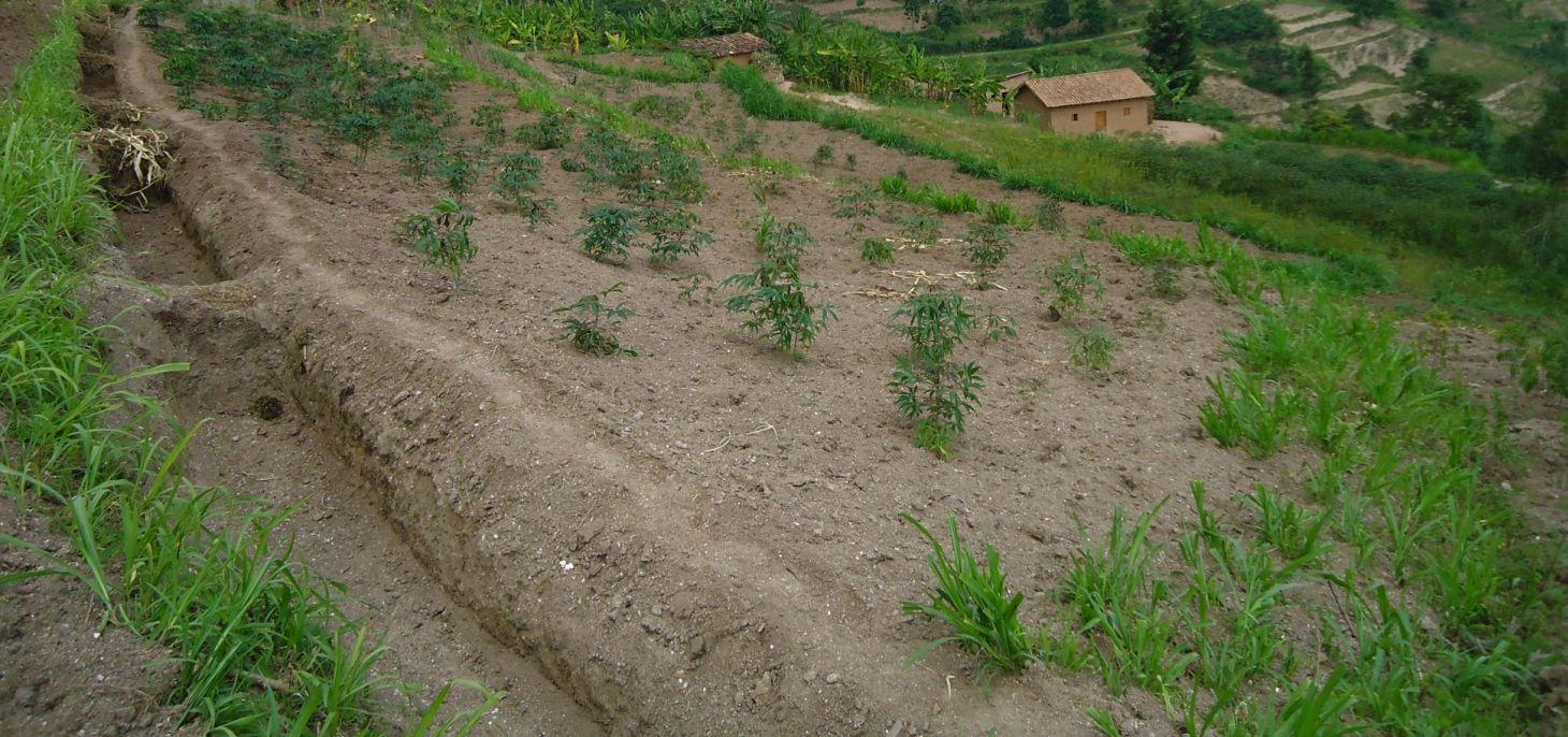
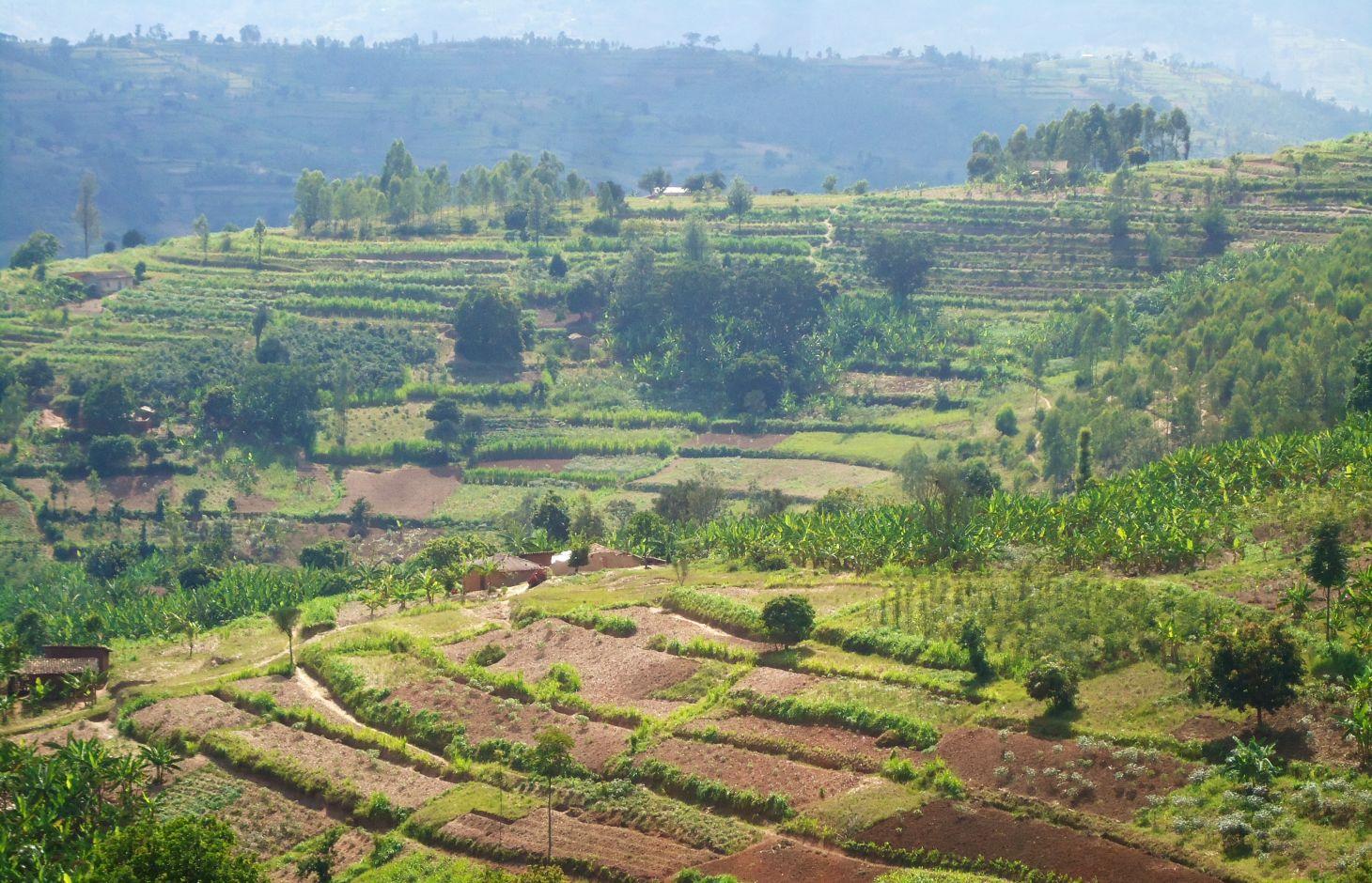
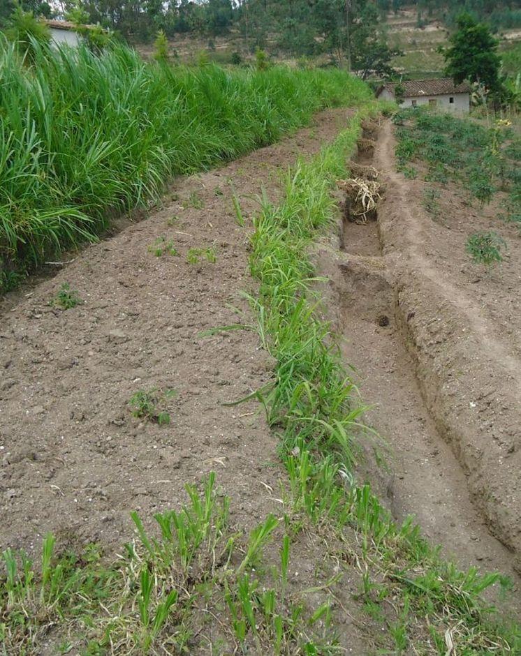
Trenches combined with living hedges or grassed lines are less labour-intensive method that is practiced in the highlands of Rwanda. The method involves digging trenches which have grass-stabilized banks, or simply planting grass strips and vegetative barriers across the slope to reduce runoff. This method, locally referred to as ‘progressive terracing’, is more adaptable by individual farmers across the country. In the study conducted by Kagabo et al. (2013) in the highlands of Buberuka Region of Rwanda, it was noted that net increment in yields and returns on investment increased with the age of terraces, since the capital costs of terracing were easily recovered. These terraces also showed more resilience, some being over 30 years old and still effective. Along the contour band, soil from the upper parts of the slope is removed and deposited above by creating a series of discontinuous trenches in order to extend the flat terrain. Over 5-10 years, the terraces become enlarged and form a terrace along the contour, such that the slopes are transformed over time into level bench terraces (but never %).
Purpose of the Technology: The main purpose of this technology is to reduce runoff and soil erosion on the slope and to improve soil quality and soil moisture retention. Grass strips or living hedgerows are intended to both trap sediments and facilitate the slow formation of terraces.
Establishment / maintenance activities and inputs: The establishment of trenches combined with living hedges or grassed lines is less labor intensive and requires less skilled labor. Regular maintenance banks on which living hedges are planted, to seasonally stream living hedges to minimize the competition of nutrients and water with plants. To efficiently use these terraces it is advisable to introduce intensive and rentable cropping systems or agroforestry with fruits and forage trees.
Natural / human environment: This technology was reported to be very resilient as trenches combined with living hedges or grassed lines of 20+ year old are still effective in controlling soil erosion. However, the soil quality on these formed terraces between alleys does not homogenize 100% over the course of time. Large soil fertility gradients with marked spatial difference in both soil quality and crop yield from their upper parts downwards of the terraces is observed. The soil in the lower parts of the terraces showed as much as 57% more organic carbon content and 31% more available phosphorous than the soil in the upper parts of the terraces (Kagabo et al. 2013).
2.3 Photos de la Technologie
Galerie Médias
2.5 Pays/ région/ lieux où la Technologie a été appliquée et qui sont couverts par cette évaluation
Pays:
Rwanda
Région/ Etat/ Province:
Rwanda
Autres spécifications du lieu:
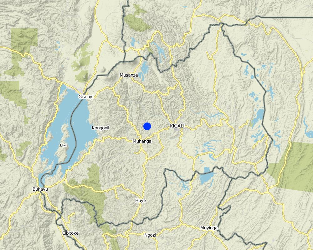
Kamonyi District (Southern Province)
Map
×2.6 Date de mise en œuvre de la Technologie
Si l'année précise est inconnue, indiquez la date approximative: :
- il y a entre 10-50 ans
2.7 Introduction de la Technologie
- Government
3. Classification de la Technologie de GDT
3.1 Principal(aux) objectif(s) de la Technologie
- réduire, prévenir, restaurer les terres dégradées
3.2 Type(s) actuel(s) d'utilisation des terres, là où la Technologie est appliquée

Terres cultivées
- Cultures annuelles
- Plantations d’arbres ou de buissons
Principales cultures (vivrières et commerciales):
major cash crop: Coffee and cassava
major food crop: Banana and beans
other: Maize
Commentaires:
Major land use problems (compiler’s opinion): Soil erosion, water contamination due to sediment loads, decrease of soil fertility and soil depth, loss of vegetation cover
Major land use problems (land users’ perception): Soil erosion, contamination of water (the turbidity of water is high) therefore the domestic use of water is a problem.
Future (final) land use (after implementation of SLM Technology): Cropland: Ca: Annual cropping
Si l'utilisation des terres a changé en raison de la mise en œuvre de la Technologie, indiquez l'utilisation des terres avant la mise en œuvre de la Technologie:
Grazing land: Ge: Extensive grazing land
3.3 Informations complémentaires sur l'utilisation des terres
Approvisionnement en eau des terres sur lesquelles est appliquée la Technologie:
- pluvial
Précisez:
Longest growing period in days: 150; Longest growing period from month to month: September – February; Second longest growing period in days: 120; Second longest growing period from month to month: March – July
Densité d'élevage/ chargement (si pertinent):
10-25 LU /km2
3.4 Groupe de GDT auquel appartient la Technologie
- Amélioration de la couverture végétale/ du sol
- mesures en travers de la pente
3.5 Diffusion de la Technologie
Spécifiez la diffusion de la Technologie:
- répartie uniformément sur une zone
Si la Technologie est uniformément répartie sur une zone, indiquez la superficie couverte approximative:
- 10-100 km2
Commentaires:
The area covered by this technology has been estimated
3.6 Mesures de GDT constituant la Technologie

pratiques végétales
- V1: Couverture d’arbres et d’arbustes
- V2: Herbes et plantes herbacées pérennes

structures physiques
- S3: Fossés étagés, canaux, voies d'eau
Commentaires:
Type of vegetative measures: aligned: -contour, aligned: -along boundary
3.7 Principaux types de dégradation des terres traités par la Technologie

érosion hydrique des sols
- Wt: perte de la couche superficielle des sols (couche arable)/ érosion de surface
- Wg: ravinement/ érosion en ravines
- Wo: effets hors-site de la dégradation
Commentaires:
Secondary types of degradation addressed: Wg: gully erosion / gullying, Wo: offsite degradation effects
Main causes of degradation: deforestation / removal of natural vegetation (incl. forest fires) (Used as energy (fire wood)), other natural causes (avalanches, volcanic eruptions, mud flows, highly susceptible natural resources, extreme topography, etc.) specify (Steep slopes in many cases are over 60%), population pressure (High density (in rural area over 400 inhabitant per ha))
Secondary causes of degradation: soil management (Less use of organic manure), crop management (annual, perennial, tree/shrub) (No proper crop rotation and all crop residues are exported), over-exploitation of vegetation for domestic use (Fodder), poverty / wealth (Farmers have low income and have less access to off farm income or remittances), education, access to knowledge and support services (High rate of irriteracy)
3.8 Prévention, réduction de la dégradation ou réhabilitation des terres dégradées
Spécifiez l'objectif de la Technologie au regard de la dégradation des terres:
- prévenir la dégradation des terres
- réduire la dégradation des terres
Commentaires:
Secondary goals: prevention of land degradation
4. Spécifications techniques, activités, intrants et coûts de mise en œuvre
4.1 Dessin technique de la Technologie
Auteur:
Kagabo Desire and Guy Ngenzi, RAB, 5016 Kigali
4.2 Spécification/ explications techniques du dessin technique
Trenches are dug in trapezoidal shape with 40 cm of height, 30 cm of base length and 50 cm of top lengths. An empty space of 40 cm is left between two consecutive trenches along a contour line.
Location: Kamonyi/Giko. Southern province
Date: 2012
Technical knowledge required for field staff / advisors: high (Special training should be provided to field staff to be able to make an adequate design and teach land users)
Technical knowledge required for land users: low (Land users are required to only implement the technology under the supervision of field staff)
Technical knowledge required for Farmer representive: high (These farmers need to be trained so that the can easily supervise the work)
Main technical functions: control of concentrated runoff: retain / trap, reduction of slope length, improvement of topsoil structure (compaction), increase of infiltration, sediment retention / trapping, sediment harvesting
Secondary technical functions: control of concentrated runoff: impede / retard, reduction of slope angle
Aligned: -contour
Vegetative material: G : grass
Number of plants per (ha): 11114
Vertical interval between rows / strips / blocks (m): 1
Spacing between rows / strips / blocks (m): 6
Vertical interval within rows / strips / blocks (m): 0.3
Width within rows / strips / blocks (m): 0.2
Aligned: -along boundary
Vegetative material: T : trees / shrubs, F : fruit trees / shrubs, G : grass
Number of plants per (ha): 84
Vertical interval between rows / strips / blocks (m): NA
Spacing between rows / strips / blocks (m): NA
Vertical interval within rows / strips / blocks (m): 20
Width within rows / strips / blocks (m): NA
Trees/ shrubs species: Grevelea/planted
Fruit trees / shrubs species: Avocado/Planted
Grass species: Napier grass/planted
Slope (which determines the spacing indicated above): 20%
If the original slope has changed as a result of the Technology, the slope today is (see figure below): 45%
Gradient along the rows / strips: 0%
Bund/ bank: level
Vertical interval between structures (m): 1.2
Spacing between structures (m): 6
Depth of ditches/pits/dams (m): 0.4
Width of ditches/pits/dams (m): 0.5
Length of ditches/pits/dams (m): 5
Height of bunds/banks/others (m): 0.4
Width of bunds/banks/others (m): 0.4
Length of bunds/banks/others (m): 5
Bund/ bank: graded
Vertical interval between structures (m): 1.2
Spacing between structures (m): 6
Depth of ditches/pits/dams (m): 0.4
Width of ditches/pits/dams (m): 0.5
Length of ditches/pits/dams (m): 5
Height of bunds/banks/others (m): 0.4
Width of bunds/banks/others (m): 0.4
Length of bunds/banks/others (m): 5
Construction material (earth): Soil excavation in farmers land along the contour
Slope (which determines the spacing indicated above): 30%
If the original slope has changed as a result of the Technology, the slope today is: 10%
Lateral gradient along the structure: 0%
Vegetation is used for stabilisation of structures.
4.3 Informations générales sur le calcul des intrants et des coûts
autre/ monnaie nationale (précisez):
Rwandan Francs
Indiquer le taux de change du dollars en monnaie locale (si pertinent): 1 USD= :
640,0
Indiquez le coût salarial moyen de la main d'œuvre par jour:
1000
4.4 Activités de mise en place/ d'établissement
| Activité | Type de mesures | Calendrier | |
|---|---|---|---|
| 1. | Cuttings | Végétale | Rainy season |
| 2. | Transport | Végétale | Rainy season |
| 3. | Planting | Végétale | Rainy season |
| 4. | Identification of contour lines, digging of trenches and grass planting on risers | Structurel | dry season |
4.5 Coûts et intrants nécessaires à la mise en place
| Spécifiez les intrants | Unité | Quantité | Coûts par unité | Coût total par intrant | % du coût supporté par les exploitants des terres | |
|---|---|---|---|---|---|---|
| Main d'œuvre | Planting | persons/day/ha | 20,0 | 1000,0 | 20000,0 | 100,0 |
| Main d'œuvre | Identification of contour lines, digging and planting | persons/day/ha | 100,0 | 1000,0 | 100000,0 | 100,0 |
| Equipements | Transport | ha | 10,0 | 1000,0 | 10000,0 | 100,0 |
| Equipements | Tools | pieces/ha | 100,0 | 1200,0 | 120000,0 | 100,0 |
| Matériel végétal | Cuttings | ha | 2,0 | 1000,0 | 2000,0 | 100,0 |
| Coût total de mise en place de la Technologie | 252000,0 | |||||
Commentaires:
Duration of establishment phase: 1 month(s)
4.6 Activités d'entretien/ récurrentes
| Activité | Type de mesures | Calendrier/ fréquence | |
|---|---|---|---|
| 1. | Weeding | Végétale | Before crop planting/each cropping season |
| 2. | Manure application and transportation | Végétale | Before crop planting/annually |
| 3. | Grass streaming | Végétale | Throughout the year |
| 4. | Clearing the ditches by removing piled up sediments. | Structurel | Rainy season |
4.7 Coûts et intrants nécessaires aux activités d'entretien/ récurrentes (par an)
| Spécifiez les intrants | Unité | Quantité | Coûts par unité | Coût total par intrant | % du coût supporté par les exploitants des terres | |
|---|---|---|---|---|---|---|
| Main d'œuvre | Weeding | persons/day/ha | 5,0 | 1000,0 | 5000,0 | 100,0 |
| Main d'œuvre | Manure application and transportation | persons/day/ha | 10,0 | 1000,0 | 10000,0 | 100,0 |
| Main d'œuvre | Grass streaming | persons/day/ha | 2,0 | 1000,0 | 2000,0 | 100,0 |
| Main d'œuvre | Clearing the ditches | persons/day/ha | 30,0 | 1000,0 | 30000,0 | 100,0 |
| Equipements | Tools | pieces/ha | 30,0 | 800,0 | 24000,0 | 100,0 |
| Coût total d'entretien de la Technologie | 71000,0 | |||||
Commentaires:
Machinery/ tools: Not applicable
The cost of labor is estimated based on land steepness, soil structure (deep, gravel or shallow soils). Land steepness defines the spacing between anti-erosion ditches hence affecting the cost of labor. Similarly, the soil structure (deep, gravel or shallow soils) defines the size of labor to be used per hectare.
4.8 Facteurs les plus importants affectant les coûts
Décrivez les facteurs les plus importants affectant les coûts :
The most determining factor affecting the cost is labor (the cost of labor increases with the nature of the soil structure as well as with the land steepness.
5. Environnement naturel et humain
5.1 Climat
Précipitations annuelles
- < 250 mm
- 251-500 mm
- 501-750 mm
- 751-1000 mm
- 1001-1500 mm
- 1501-2000 mm
- 2001-3000 mm
- 3001-4000 mm
- > 4000 mm
Zone agro-climatique
- subhumide
Thermal climate class: tropics
5.2 Topographie
Pentes moyennes:
- plat (0-2 %)
- faible (3-5%)
- modéré (6-10%)
- onduleux (11-15%)
- vallonné (16-30%)
- raide (31-60%)
- très raide (>60%)
Reliefs:
- plateaux/ plaines
- crêtes
- flancs/ pentes de montagne
- flancs/ pentes de colline
- piémonts/ glacis (bas de pente)
- fonds de vallée/bas-fonds
Zones altitudinales:
- 0-100 m
- 101-500 m
- 501-1000 m
- 1001-1500 m
- 1501-2000 m
- 2001-2500 m
- 2501-3000 m
- 3001-4000 m
- > 4000 m
5.3 Sols
Profondeur moyenne du sol:
- très superficiel (0-20 cm)
- superficiel (21-50 cm)
- modérément profond (51-80 cm)
- profond (81-120 cm)
- très profond (>120 cm)
Texture du sol (de la couche arable):
- moyen (limoneux)
- fin/ lourd (argile)
Matière organique de la couche arable:
- moyen (1-3%)
- faible (<1%)
Si disponible, joignez une description complète du sol ou précisez les informations disponibles, par ex., type de sol, pH/ acidité du sol, capacité d'échange cationique, azote, salinité, etc.
Soil fertility is medium
Soil drainage / infiltration is good
Soil water storage capacity is medium
5.4 Disponibilité et qualité de l'eau
Profondeur estimée de l’eau dans le sol:
5-50 m
Disponibilité de l’eau de surface:
faible/ absente
Qualité de l’eau (non traitée):
faiblement potable (traitement nécessaire)
5.5 Biodiversité
Diversité des espèces:
- moyenne
5.6 Caractéristiques des exploitants des terres appliquant la Technologie
Orientation du système de production:
- subsistance (auto-approvisionnement)
Revenus hors exploitation:
- moins de 10% de tous les revenus
Niveau relatif de richesse:
- très pauvre
- pauvre
Individus ou groupes:
- individu/ ménage
Niveau de mécanisation:
- travail manuel
Genre:
- femmes
- hommes
Indiquez toute autre caractéristique pertinente des exploitants des terres:
Land users applying the Technology are mainly common / average land users
Population density: 50-100 persons/km2
Annual population growth: 2% - 3%; 3%
75% of the land users are poor and own 75% of the land.
30% of the land users are poor and own 25% of the land.
5.7 Superficie moyenne des terres détenues ou louées par les exploitants appliquant la Technologie
- < 0,5 ha
- 0,5-1 ha
- 1-2 ha
- 2-5 ha
- 5-15 ha
- 15-50 ha
- 50-100 ha
- 100-500 ha
- 500-1 000 ha
- 1 000-10 000 ha
- > 10 000 ha
Cette superficie est-elle considérée comme de petite, moyenne ou grande dimension (en se référant au contexte local)?
- petite dimension
5.8 Propriété foncière, droits d’utilisation des terres et de l'eau
Propriété foncière:
- individu, avec titre de propriété
Droits d’utilisation des terres:
- individuel
Droits d’utilisation de l’eau:
- accès libre (non organisé)
5.9 Accès aux services et aux infrastructures
santé:
- pauvre
- modéré
- bonne
éducation:
- pauvre
- modéré
- bonne
assistance technique:
- pauvre
- modéré
- bonne
emploi (par ex. hors exploitation):
- pauvre
- modéré
- bonne
marchés:
- pauvre
- modéré
- bonne
énergie:
- pauvre
- modéré
- bonne
routes et transports:
- pauvre
- modéré
- bonne
eau potable et assainissement:
- pauvre
- modéré
- bonne
services financiers:
- pauvre
- modéré
- bonne
6. Impacts et conclusions
6.1 Impacts sur site que la Technologie a montrés
Impacts socio-économiques
Production
production agricole
Quantité avant la GDT:
3472
Quantité après la GDT:
10416
Commentaires/ spécifiez:
Yield of beans increased
production fourragère
Quantité avant la GDT:
40
Quantité après la GDT:
160
Commentaires/ spécifiez:
Grasses availability increases because grasses are growing along the contours
surface de production
Revenus et coûts
charge de travail
Impacts socioculturels
connaissances sur la GDT/ dégradation des terres
Quantité avant la GDT:
1
Quantité après la GDT:
30
Commentaires/ spécifiez:
The technology improved awareness regarding soil erosion control
apaisement des conflits
Quantité avant la GDT:
20
Quantité après la GDT:
80
Commentaires/ spécifiez:
Production per unit area increased considerably thus theft between farmers have been reduced
livelihood and human well-being
Commentaires/ spécifiez:
Increase in agricultural production has contributed to income generation and provide needed school fees
Impacts écologiques
Cycle de l'eau/ ruissellement
récolte/ collecte de l'eau
ruissellement de surface
Sols
humidité du sol
couverture du sol
perte en sol
Autres impacts écologiques
hazard towards adverse events
6.2 Impacts hors site que la Technologie a montrés
envasement en aval
dommages sur les champs voisins
Commentaires/ spécifiez:
Each farmer use his land without causing damage in the down neighbor's land
6.3 Exposition et sensibilité de la Technologie aux changements progressifs et aux évènements extrêmes/catastrophes liés au climat (telles que perçues par les exploitants des terres)
Changements climatiques progressifs
Changements climatiques progressifs
| Saison | Type de changements/ extrêmes climatiques | Comment la Technologie fait-elle face à cela? | |
|---|---|---|---|
| températures annuelles | augmente | bien |
Extrêmes climatiques (catastrophes)
Catastrophes météorologiques
| Comment la Technologie fait-elle face à cela? | |
|---|---|
| pluie torrentielle locale | pas bien |
| tempête de vent locale | bien |
Catastrophes climatiques
| Comment la Technologie fait-elle face à cela? | |
|---|---|
| sécheresse | bien |
Catastrophes hydrologiques
| Comment la Technologie fait-elle face à cela? | |
|---|---|
| inondation générale (rivière) | pas bien |
Autres conséquences liées au climat
Autres conséquences liées au climat
| Comment la Technologie fait-elle face à cela? | |
|---|---|
| réduction de la période de croissance | bien |
6.4 Analyse coûts-bénéfices
Quels sont les bénéfices comparativement aux coûts de mise en place (du point de vue des exploitants des terres)?
Rentabilité à court terme:
neutre / équilibrée
Rentabilité à long terme:
très positive
Quels sont les bénéfices comparativement aux coûts d'entretien récurrents (du point de vue des exploitants des terres)?
Rentabilité à court terme:
légèrement négative
Rentabilité à long terme:
très positive
6.5 Adoption de la Technologie
- plus de 50%
Si disponible, quantifiez (nombre de ménages et/ou superficie couverte):
207 households covering 100 percent of the stated area
Parmi tous ceux qui ont adopté la Technologie, combien d'entre eux l'ont fait spontanément, à savoir sans recevoir aucune incitation matérielle ou aucun paiement?
- 90-100%
Commentaires:
207 land user families have adopted the Technology without any external material support
There is a strong trend towards spontaneous adoption of the Technology
Comments on adoption trend: 100% of farmers has adopted the technology
6.7 Points forts/ avantages/ possibilités de la Technologie
| Points forts/ avantages/ possibilités du point de vue de l'exploitant des terres |
|---|
|
To prevent soil erosion How can they be sustained / enhanced? Maintenance of contour lines |
|
Grasses provide mulching How can they be sustained / enhanced? Proper maintenance of grasses on contour lines |
| Points forts/ avantages/ possibilités du point de vue du compilateur ou d'une autre personne ressource clé |
|---|
|
Mitigation of land degradation due to soil erosion How can they be sustained / enhanced? Continuous sensitization and enforcement by government to land users to stabilize the technology. |
|
Increased crop productivity How can they be sustained / enhanced? Continuous training from government and give all basic necessary support services to land users |
|
Increased fodder production How can they be sustained / enhanced? Proper maintenance of the technology by land users |
6.8 Faiblesses/ inconvénients/ risques de la Technologie et moyens de les surmonter
| Faiblesses/ inconvénients/ risques du point de vue de l’exploitant des terres | Comment peuvent-ils être surmontés? |
|---|---|
| It is hard to implement mainly by older and poor land users | It is required to offer communal support or financial support from development partners |
| Faiblesses/ inconvénients/ risques du point de vue du compilateur ou d'une autre personne ressource clé | Comment peuvent-ils être surmontés? |
|---|---|
| It requires a lot of physical energy, elderly people can't afford | Help each other through communal work (umuganda) |
| Labor costs | Land users with less financial means should join their efforts by working together |
7. Références et liens
7.2 Références des publications disponibles
Titre, auteur, année, ISBN:
Kagera TAMP project website
Disponible à partir d'où? Coût?
http://www.fao.org/nr/kagera/en/
Titre, auteur, année, ISBN:
Participatory Integrated Watershed Managementin the north-western highlands of RwandaMbarushimana Désiré2013
Disponible à partir d'où? Coût?
http://www.wageningenur.nl/nl/show/Desire-Kagabo-Participatory-Integrated-Watershed-Management-in-the-northwestern-highlands-of-Rwanda.htm
Liens et modules
Développer tout Réduire toutLiens
Aucun lien
Modules
Aucun module trouvé