Dug-Out Well [ប្រទេសឥណ្ឌា]
- ការបង្កើត៖
- បច្ចុប្បន្នភាព
- អ្នកចងក្រង៖ Unknown User
- អ្នកកែសម្រួល៖ –
- អ្នកត្រួតពិនិត្យច្រើនទៀត៖ Alexandra Gavilano, Fabian Ottiger
Chahala
technologies_1088 - ប្រទេសឥណ្ឌា
ពិនិត្យមើលគ្រប់ផ្នែក
ពង្រីកមើលទាំងអស់ បង្រួមទាំងអស់1. ព័ត៌មានទូទៅ
1.2 ព័ត៌មានលម្អិតពីបុគ្គលសំខាន់ៗ និងស្ថាប័នដែលចូលរួមក្នុងការវាយតម្លៃ និងចងក្រងឯកសារនៃបច្ចេកទេស
បុគ្គលសំខាន់ម្នាក់ (ច្រើននាក់)
អ្នកជំនាញឯកទេស SLM:
Kar Monoranjan
Project implementing agency, 9437287808
អ្នកជំនាញឯកទេស SLM:
Mohanty Rajib
Watersheds office, DRDA, Balangir, 09437241751
ឈ្មោះអង្គភាពមួយ (ច្រើន) ដែលបានចងក្រងឯកសារ/ វាយតម្លៃបច្ចេកទេស (បើទាក់ទង)
Watershed Office DRDA - ប្រទេសឥណ្ឌា1.3 លក្ខខណ្ឌទាក់ទងទៅនឹងការប្រើប្រាស់ទិន្នន័យដែលបានចងក្រងតាមរយៈ វ៉ូខេត
អ្នកចងក្រង និង(បុគ្គលសំខាន់ៗ)យល់ព្រមទទួលយកនូវលក្ខខណ្ឌនានាទាក់ទងទៅនឹងការប្រើប្រាស់ទិន្នន័យដែលបានចងក្រងតាមរយៈវ៉ូខេត:
បាទ/ចា៎
2. ការពណ៌នាពីបច្ចេកទេស SLM
2.1 ការពណ៌នាដោយសង្ខេបពីបច្ចេកទេស
និយមន័យបច្ចេកទេស:
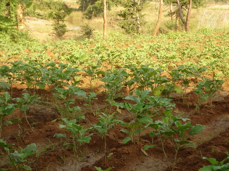
It can be defined as combination of structural & agronomic measures where along with other technology like Water harvesting structures & field bunding on the upper reaches & a dug out well is constructed in the periphery of the drainage line which is a govt land. The 15 acres of land near to its sphere of influence which reamained fallow earlier could yield good production system throughout the year.It is in the semi-arid climatic zone with moderate slope in medium soil depth conditions. The whole idea is to avail water & link with self-subsistance & market oriented production systems from private lands.
2.2 ការពណ៌នាលម្អិតពីបច្ចេកទេស
ការពណ៌នា:
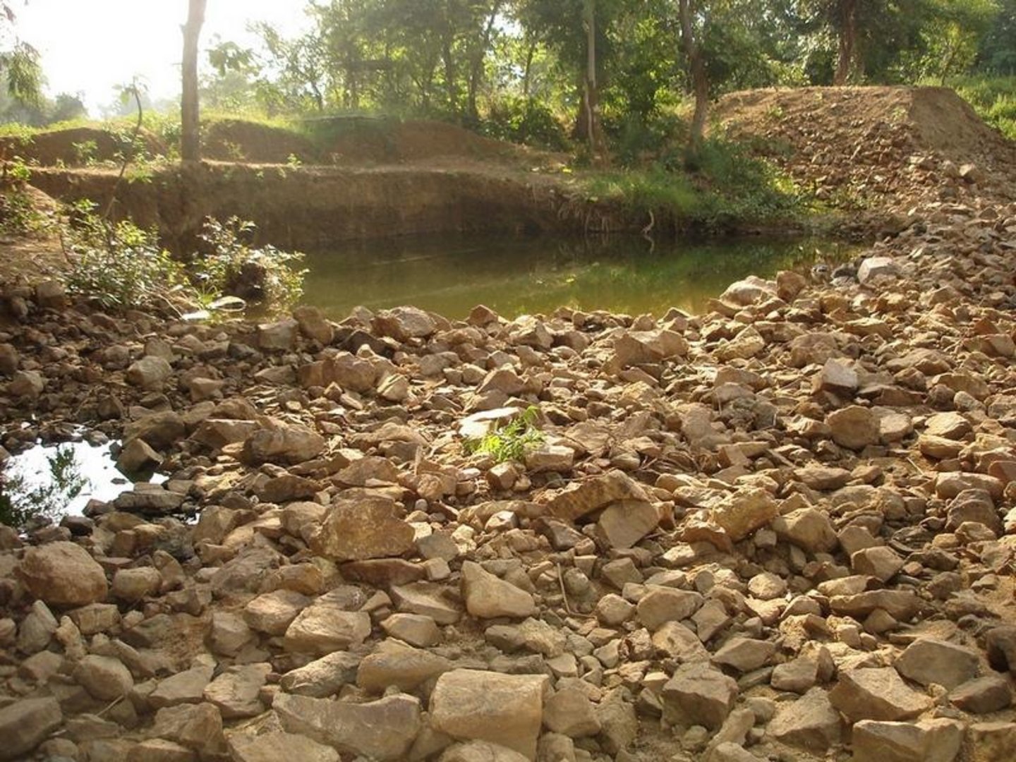
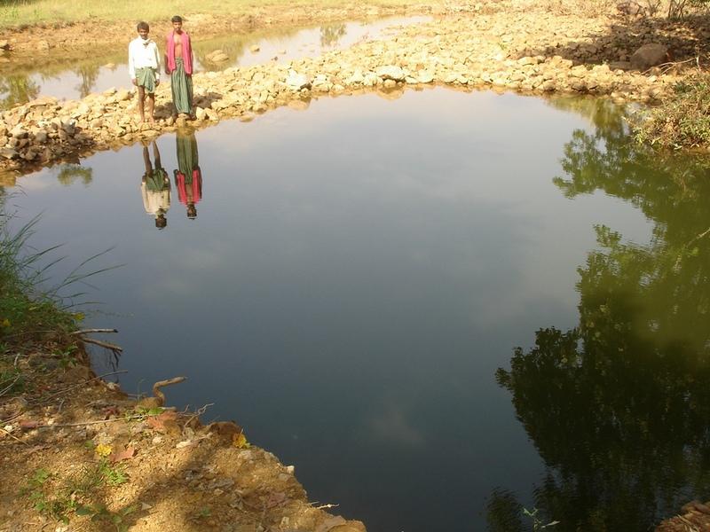
The area is located at the foot-slopes on the major drainage line of the watershed. The technology area is located near the main drainage line, therefore, the sub-surface water availability is more & can be utilised for cultivation of crop even in dry spell of the year. Earlier the farmers near to this place tried to dig a small well & could irrigate for only 2-3 months of the year to get some subsistence crops. Therefore, water availability throughout the year is a first priority of the farmers. At the outset, a livelihood focused micro-plan had been prepared by the villagers stating the details of the base-line data along with problems & alternative solutions. The patch was identified to be the worst affected & the owners of the land are poor people (defined by villagers). Usually the land users used to migrate in search of labour due to loss in the agriculture. It is because the water availability is not there at the time of requirement. The people of this patch are ready to contribute at least 10% of the cost as the structure is to be constructed in government land. In the mean time the project sent the PIA to Water technology centre for eastern region, Bhubneswar to study the linking of water harvesting structure & dug-out well & its relevance in this context of our situation. The technology was done in the village Chareimara which is one out of 3 villages of one watershed, located at the lower reach of the watershed. In the meantime many water harvesting structures & field bunds were constructed due to which the water could be stored in the recharge zone. This area is again a mix of stony patches in the crop land. One water harvesting structure was constructed just at the upper reaches. The surrounding area was totally unbunded with clay loam soil. Therefore, land users are of opinion to go for a deeper dug well which can feed water through out to at least 15 acre of land. The requirement of land users was to get some water in each farmers land to protect the Kharif & rabi crop including summer vegetables. A four-day in field training was conducted by the project to community link workers (SWC), particularly on patch treatment, use of levelling instruments like A-frame, proper planning, design, lay-out of different type of structure in a map & ground. At the same time there was a blind belief that large water harvesting structures are more useful to farmers. So the land users demanded for a large WHS on the drainage bed which requires huge investment & high maintenance cost. But when some farmers of that watershed could get good result by digging well these land users also started thinking about a "community dug-well". After many rounds of discussion with the land users by the SWC specialist followed by a detail transact along with land users, the results of first round transact was mentioned in the micro-plan. But the aim behind subsequent transact was to looking at problems & demarcating on the map. After that estimate was prepared & lay-out of the well was done by SWC specialist with the help of community link workers & land users. The lay-out is also little bit different from traditional well i.e. square shaped in stead of round shape. The work was implemented by the land users & 7 outside labourers with the supervision of the User's group leader & monitoring was done by the SWC specialist. The priority by the land users was agronomic measures like changing the crop in the land. Training was conducted on the probable alternatives of agronomic measures like taking of crop which is of little longer duration, intercrops & cash crops etc. The structural measures are subsidised by the project & the agronomic measures was taken up on loan basis. The development fund was also generated out of contribution from the land users which was deposited in a separate account for future maintenance cost.
2.3 រូបភាពនៃបច្ចេកទេស
វិចិត្រសាលប្រព័ន្ធផ្សព្វផ្សាយ

2.5 ប្រទេស/តំបន់/ទីតាំងកន្លែង ដែលបច្ចេកទេសត្រូវបានអនុវត្ត និងបានគ្រប់ដណ្តប់ដោយការវាយតម្លៃនេះ
ប្រទេស:
ប្រទេសឥណ្ឌា
បញ្ជាក់បន្ថែមពីលក្ខណៈនៃទីតាំង:
Orissa, Balangir, Suktel/Mahanadi
បញ្ជាក់ពីការសាយភាយនៃបច្ចេកទេស:
- ត្រូវបានផ្សព្វផ្សាយត្រឹមតំបន់មួយ
ប្រសិនបើបច្ចេកទេសត្រូវបានសាយភាយពាសពេញតំបន់ណាមួយ បញ្ជាក់ទំហំផ្ទៃដីអនុវត្តន៍ (គិតជា គ.ម2):
0,6
ប្រសិនបើមិនច្បាស់ពីទំហំផ្ទៃដី សូមធ្វើការប៉ាន់ប្រម៉ាណ:
- 0.1-1 គម2
មតិយោបល់:
Total area covered by the SLM Technology is 0.6 km2.
The concerned watershed is a subsidiary system of the Suktel river drainage sytem. The area of operation is micro watershed , i.e. 500 hac as a unit of the tributary of the Suktel river
Map
×2.6 កាលបរិច្ឆេទនៃការអនុវត្ត
ប្រសិនបើមិនច្បាស់ឆ្នាំ សូមបញ្ជាក់កាលបរិច្ឆេទដែលប្រហាក់ប្រហែល:
- តិចជាង 10ឆ្នាំមុន (ថ្មី)
2.7 ការណែនាំពីបច្ចេកទេស
សូមបញ្ជាក់តើបច្ចេកទេសត្រូវបានណែនាំឱ្យអនុវត្តដោយរបៀបណា:
- តាមរយៈគម្រោង / អន្តរាគមន៍ពីខាងក្រៅ
មតិយោបល់ (ប្រភេទនៃគម្រោង ។ល។):
A group of SWC proffessionals were sent to WTCER, Bhubaneswar to study the replication of ' Linking of water harvesting structure with dug-out wells. . When SWC specialist share their experience to land users, some of the farmers agreed to have a experimentation of the technology. Therefore, modification has been done by the SWC specialists as per the suitability & requirement of the land users.
3. ចំណាត់ថ្នាក់នៃបច្ចេកទេស SLM
3.2 ប្រភេទដីប្រើប្រាស់មួយប្រភេទ (ច្រើនប្រភេទ) ដែលបានអនុវត្តបច្ចេកទេស

ដីដាំដំណាំ
- ដំណាំប្រចាំឆ្នាំ
- ដំណាំរយៈពេលវែង (មិនមែនឈើ)
ដំណាំប្រចាំឆ្នាំ - បញ្ជាក់ប្រភេទដំណាំ:
- បន្លែ - ត្រសក់ផ្អែម ល្ពៅ ពពួកបន្លែទ្រើង
- បន្លែ - ផ្សេងៗ
- បន្លែ - បន្លែយកមើម (ការ៉ុត ខ្ទឹមបារាំង ឆៃថាវម្យ៉ាង ផ្សេងៗ)
- rice
ដំណាំរយៈពេលវែង (មិនមែនឈើ) - បញ្ជាក់ប្រភេទដំណាំ:
- អំពៅ
ចំនួនសារដែលដាំដំណាំក្នុងមួយឆ្នាំ:
- 2
សូមបញ្ជាក់:
Longest growing period in days: 120Longest growing period from month to month: Jun - OctSecond longest growing period in days: 80Second longest growing period from month to month: Oct - Feb
តើជាការអនុវត្តន៍ដំណាំចន្លោះ?
បាទ/ចា៎
ប្រសិនបើបាទ/ច៎ា សូមបញ្ជាក់ប្រភេទដំណាំដែលដាំចន្លោះគ្នានោះ:
Mixed cropping / intercropping
Material/ species: Gourd, Brinjal, onion, sugarcane,water melon
Remarks: After the Kharif crop
មតិយោបល់:
Major land use problems (compiler’s opinion): This patch of the land used to remian fallow in comparison to other lands of the village, with high concentration of marginal farmer. Due to less water availability at the time of need of crop the farmers were quite hesitant to take up diversified crop. They used to migrated instead of taking up any agriculure due to loss year afte year. The main requirement of water throught out the year.
Major land use problems (land users’ perception): 1. Run-off was severe at the time of rainy season but difficult to capture water for other period of the year.2. Long duration crops is not possible, ex- paddy,pulses, sugarcane, vegetables etc. 3. Although land is there but it remained fallow in the past due to water availability. They were the migrants because of onstraint in agriculture.
Type of cropping system and major crops comments: Paddy/Kharif rainfed vegetables, Winter vegetables & spices, summer vegetables. Gourd, Brinjal, onion, sugarcane,water melon
3.4 ការផ្គត់ផ្គង់ទឹក
ផ្សេងៗ (ឧ. ក្រោយពីទឹកជំនន់):
- all of them
មតិយោបល់:
Water supply: rainfed, mixed rainfed - irrigated
3.6 វិធានការ SLM ដែលបញ្ចូលនូវបច្ចេកទេស

វិធានការក្សេត្រសាស្ត្រ
- A1: ដំណាំ/គម្របដី
- A2: សារធាតុសរីរាង្គ/ជីជាតិដី
- A5: ការគ្រប់គ្រងគ្រាប់ពូជ បង្កើនប្រភេទពូជ
- A7: ផ្សេងៗ

វិធានការរចនាស័ម្ពន្ធ
មតិយោបល់:
Type of agronomic measures: better crop cover, early planting, mixed cropping / intercropping, manure / compost / residues, mineral (inorganic) fertilizers, rotations / fallows, breaking compacted topsoil, deep tillage / double digging
3.7 កំណត់ប្រភេទនៃការធ្លាក់ចុះគុណភាពដីសំខាន់ៗដែលបច្ចេកទេសនេះបានដោះស្រាយ

ការហូរច្រោះដីដោយសារទឹក
- Wr: សំណឹកដីច្រាំងទន្លេ
3.8 ការពារ កាត់បន្ថយ ឬស្តារឡើងវិញនៃការធ្លាក់ចុះគុណភាពដី
បញ្ជាក់ពីគោលដៅរបស់បច្ចេកទេស ដែលផ្តោតទៅការធ្លាក់ចុះគុណភាពដី:
- ការការពារការធ្លាក់ចុះគុណភាពដី
- ការជួសជុល/ ស្តារឡើងវិញនៃឱនភាពដីធ្ងន់ធ្ងរ
មតិយោបល់:
reclamation of denuded land
4. បច្ចេកទេសជាក់លាក់ សកម្មភាពអនុវត្ត ធាតុចូល និងថ្លៃដើម
4.1 គំនូសបច្ចេកទេសនៃបច្ចេកទេសនេះ
លក្ខណៈពិសេសនៃបច្ចេកទេស (ទាក់ទងនឺងគំនូរបច្ចេកទេស):
Dug Well in Chareimara
Technical knowledge required for field staff / advisors: low
Technical knowledge required for land users: low
Main technical functions: control of dispersed runoff: retain / trap, water harvesting / increase water supply
Secondary technical functions: control of concentrated runoff: impede / retard, water spreading
Better crop cover
Material/ species: paddy, vegetables,
Quantity/ density: Average
Remarks: Paddy for subsistence & vegetables in the land with rainfed & market demand.
Mixed cropping / intercropping
Material/ species: Gourd, Brinjal, onion, sugarcane,water melon
Quantity/ density: ealy harve
Remarks: After the Kharif crop
Manure / compost / residues
Material/ species: 4 -5 cartloads of cow-dung
Mineral (inorganic) fertilizers
Material/ species: Minimum basal doses
Rotations / fallows
Material/ species: the cultivation of crop started after the availability of water.
Remarks: Rainfed paddy with vegetables
Breaking compacted topsoil
Remarks: As the land was fallow earlier, breaking of compact soil is necessary.
Deep tillage / double digging
Remarks: The land where vegetables was grown, deep tillage was required
Structural measure: diversion ditch / cut-off drain
Depth of ditches/pits/dams (m): 26ft
Width of ditches/pits/dams (m): 35ft
Length of ditches/pits/dams (m): 33ft
Construction material (stone): Stone excavetd from the well was put as protection embankment
Construction material (concrete): A concrete guard wall will be put on the periphery of well which will be started in the current year
For water harvesting: the ratio between the area where the harvested water is applied and the total area from which water is collected is: 1:150
Change of land use type: After paddy & kharif vegetables,rabi & summer vegetables .Th e bunds of the patch need to be covered with plants
Change of land use practices / intensity level: Inter crops, mixed crops have to be practiced to get optimum benefit.
Layout change according to natural and human environment: Grazing was restricted in these areas & land was optimally used, like bund cultivation.
Major change in timing of activities: Early varieties of vegetables will fetch at least double benefit.
Control / change of species composition: The improved varities seed need to be introduced
4.2 ព័ត៌មានទូទៅដែលពាក់ព័ន្ធនឹងការគណនាធាតុចូល និងថ្លៃដើម
ផ្សេងៗ/ រូបិយប័ណ្ណជាតិ (បញ្ជាក់):
Rupee
បើពាក់ព័ន្ធសូមកំណត់អត្រាប្តូរប្រាក់ពីដុល្លាទៅរូបិយប័ណ្ណតំបន់ (ឧ. 1 ដុល្លារ = 79.9 រៀលនៃរូបិយប័ណ្ណប្រេស៊ីល) ៖ 1 ដុល្លារ =:
50,0
កំណត់ថ្លៃឈ្នួលជាមធ្យមនៃការជួលកម្លាំងពលកម្មក្នុងមួយថ្ងៃ:
1.00
4.3 សកម្មភាពបង្កើត
| សកម្មភាព | រយៈពេល (រដូវកាល) | |
|---|---|---|
| 1. | Survey | April-May |
| 2. | Demarkation on map | April-May |
| 3. | Estimate & lay-Out | April-May |
| 4. | Implementation of work | May-July |
| 5. | Survey & demarkation of water line | April |
| 6. | Digging of well | May-July |
| 7. | Water-way | August |
4.4 ថ្លៃដើម និងធាតុចូលដែលត្រូវការសម្រាប់ការបង្កើតបច្ចេកទេស
| បញ្ជាក់ពីធាតុចូល | ឯកតា | បរិមាណ | ថ្លៃដើមក្នុងមួយឯកតា | ថ្លៃធាតុចូលសរុប | % នៃថ្លៃដើមដែលចំណាយដោយអ្នកប្រើប្រាស់ដី | |
|---|---|---|---|---|---|---|
| កម្លាំងពលកម្ម | Medium | hectare | 1,0 | 1250,0 | 1250,0 | |
| ថ្លៃដើមសរុបក្នុងការបង្កើតបច្ចេកទេស | 1250,0 | |||||
| ថ្លៃដើមសរុបក្នុងការបង្កើតបច្ចេកទេសគិតជាដុល្លារ | 25,0 | |||||
មតិយោបល់:
Duration of establishment phase: 24 month(s)
4.5 សកម្មភាពថែទាំ
| សកម្មភាព | ពេលវេលា/ ភាពញឹកញាប់ | |
|---|---|---|
| 1. | Ploughing | April-May / |
| 2. | Intercultural operation with manure & compost application | June / |
| 3. | Sowing of paddy & rainfed vegetables | July & sep for two crops / |
| 4. | weeding & intercultural operation, if required. | July / |
| 5. | Harvesting of paddy orvegetables or sugarcane. | Nov / |
| 6. | Winter early variety vegetables like onion, brinjal, leafy vegetables, gourds etc. | Dec / |
| 7. | Harvesting of winter spices & vegetables | Feb-March / |
| 8. | Sowing of summer vegetables like water melon etc | March / |
| 9. | Intercultural operation | April / |
| 10. | Harvesting of vegetables | May / |
| 11. | Management of surplus water | Rainy Season/annual |
| 12. | Collapsing of bund | annual |
| 13. | Well must be desilted | Dry season/each cropping season |
| 14. | Control of surplus water-flow | August-Sep / annual |
| 15. | Stabilisation of bund at weak points | Nov-Dec / annual |
| 16. | Desiltation of well | April-may / annual |
4.7 កត្តាសំខាន់បំផុតដែលមានឥទ្ធិពលដល់ការចំណាយ
ពណ៌នាពីកត្តាប៉ះពាល់ចម្បងៗទៅលើថ្លៃដើម:
Stones are to be excavated from such a height of 26 ft.
5. លក្ខណៈបរិស្ថានធម្មជាតិ និងមនុស្ស
5.1 អាកាសធាតុ
បរិមាណទឹកភ្លៀងប្រចាំឆ្នាំ
- < 250 មម
- 251-500 មម
- 501-750 មម
- 751-1,000 មម
- 1,001-1,500 មម
- 1,501-2,000 មម
- 2,001-3,000 មម
- 3,001-4,000 មម
- > 4,000 មម
តំបន់កសិអាកាសធាតុ
- មានភ្លៀងមធ្យម
- មានភ្លៀងតិចតួច
5.2 សណ្ឋានដី
ជម្រាលជាមធ្យម:
- រាបស្មើ (0-2%)
- ជម្រាលតិចតួច (3-5%)
- មធ្យម (6-10%)
- ជម្រាលខ្ពស់បន្តិច (11-15%)
- ទីទួល (16-30%)
- ទីទួលចោត (31-60%)
- ទីទួលចោតខ្លាំង (>60%)
ទម្រង់ដី:
- ខ្ពង់រាប
- កំពូលភ្នំ
- ជម្រាលភ្នំ
- ជម្រាលទួល
- ជម្រាលជើងភ្នំ
- បាតជ្រលងភ្នំ
តំបន់តាមរយៈកម្ពស់ :
- 0-100 ម
- 101-500 ម
- 501-1,000 ម
- 1,001-1,500 ម
- 1,501-2,000 ម
- 2,001-2,500 ម
- 2,501-3,000 ម
- 3,001-4,000 ម
- > 4,000 ម
5.3 ដី
ជម្រៅដីជាមធ្យម:
- រាក់ខ្លាំង (0-20 សម)
- រាក់ (21-50 សម)
- មធ្យម (51-80 សម)
- ជ្រៅ (81-120 សម)
- ជ្រៅខ្លាំង (> 120 សម)
វាយនភាពដី (ស្រទាប់លើ):
- មធ្យម (ល្បាយ, ល្បាប់)
- ម៉ត់/ ធ្ងន់ (ឥដ្ឋ)
សារធាតុសរីរាង្គនៅស្រទាប់ដីខាងលើ:
- មធ្យម (1-3%)
- ទាប (<1%)
5.6 លក្ខណៈនៃអ្នកប្រើប្រាស់ដីដែលអនុវត្តបច្ចេកទេស
ទីផ្សារនៃប្រព័ន្ធផលិតកម្ម:
- សម្រាប់ហូបក្នុងគ្រួសារ (ផ្គត់ផ្គង់ខ្លួនឯង)
- ពាណិជ្ជកម្ម/ ទីផ្សារ
ចំណូលក្រៅកសិកម្ម:
- តិចជាង 10% នៃចំណូល
កម្រិតជីវភាព:
- មិនល្អខ្លាំង
- មិនល្អ
កម្រិតប្រើប្រាស់គ្រឿងយន្ត:
- ប្រើកម្លាំងពលកម្ម
- ប្រើកម្លាំងសត្វ
សូមបញ្ជាក់ពីលក្ខណៈពាក់ព័ន្ធផ្សេងទៀតអំពីអ្នកប្រើប្រាស់ដី:
1% of the land users are poor (2-3 acres of land).
Off-farm income specification: Others have also activities like NTFP collection, keeping small ruminants like goats, chicks etc.
5.7 ទំហំផ្ទៃដីជាមធ្យមនៃដីប្រើប្រាស់ដោយអ្នកប្រើប្រាស់ដី ក្នុងការអនុវត្តបច្ចេកទេស
- < 0.5 ហិកតា
- 0.5-1 ហិកតា
- 1-2 ហិកតា
- 2-5 ហិកតា
- 5-15 ហិកតា
- 15-50 ហិកតា
- 50-100 ហិកតា
- 100-500 ហិកតា
- 500-1,000 ហិកតា
- 1,000-10,000 ហិកតា
- > 10,000 ហិកតា
មតិយោបល់:
Average area of land owned or leased by land users applying the Technology: 0.5-1 ha, 0.5-1 ha, 1-2 ha, 1-2 ha
5.8 ភាពជាម្ចាស់ដី កម្មសិទ្ធប្រើប្រាស់ដី និងកម្មសិទ្ធប្រើប្រាស់ទឹក
ភាពជាម្ចាស់ដី:
- ឯកជន មានកម្មសិទ្ធ
កម្មសិទ្ធិប្រើប្រាស់ដី:
- ឯកជន
6. ផលប៉ះពាល់ និងការសន្និដ្ឋាន
6.1 ផលប៉ះពាល់ក្នុងបរិវេណអនុវត្តបច្ចេកទេសដែលកើតមាន
ផលប៉ះពាល់លើសេដ្ឋកិច្ចសង្គម
ផលិតផល
ផលិតកម្មដំណាំ
ចំណូល និងថ្លៃដើម
ចំណូលក្នុងកសិដ្ឋាន
ផលប៉ះពាល់ទៅលើវប្បធម៌សង្គម
ស្ថាប័នសហគមន៍
ការកាត់បន្ថយជម្លោះ
ផលប៉ះពាល់ទៅលើអេកូឡូស៊ី
វដ្តទឹក/លំហូរ
ប្រព័ន្ធបង្ហូរទឹក
6.2 ផលប៉ះពាល់ក្រៅបរិវេណអនុវត្តបច្ចេកទេសដែលកើតមាន
លំហូរទឹកដែលអាចប្រើប្រាស់បាននៅរដូវប្រាំង
6.4 ការវិភាគថ្លៃដើម និងអត្ថប្រយោជន៍
តើផលចំណេញ និងថ្លៃដើមត្រូវបានប្រៀបធៀបគ្នាយ៉ាងដូចម្តេច (ទស្សនៈរបស់អ្នកប្រើប្រាស់ដី)?
រយៈពេលខ្លី:
ប៉ះពាល់តិចតួចបំផុត
រយៈពេលវែង:
វិជ្ជមានខ្លាំង
តើផលចំណេញ និងការថែទាំ/ ជួសជុលត្រូវបានប្រៀបធៀបគ្នាយ៉ាងដូចម្តេច (ទស្សនៈរបស់អ្នកប្រើប្រាស់ដី)?
រយៈពេលខ្លី:
អវិជ្ជមានតិចតួច
រយៈពេលវែង:
វិជ្ជមានតិចតួច
6.5 ការទទួលយកបច្ចេកទេស
មតិយោបល់:
100% of land user families have adopted the Technology with external material support
10 land user families have adopted the Technology with external material support
Comments on acceptance with external material support: survey results
6.7 ភាពខ្លាំង/ គុណសម្បត្តិ/ ឱកាសនៃបច្ចេកទេស
| ភាពខ្លាំង/ គុណសម្បត្តិ/ ឱកាសនៅកន្លែងរបស់អ្នកប្រើប្រាស់ដី |
|---|
| Water availilbilty |
| A vibrant community institution could be strngthed. |
| A well is much better than a large water harvesting structure, it became a eye opener in the surrounding villages. |
| ភាពខ្លាំង/ គុណសម្បត្តិ/ ឱកាស ទស្សនៈរបស់បុគ្គលសំខាន់ៗ |
|---|
|
Water availability in the dry spell How can they be sustained / enhanced? Integrated & threes season land use practice |
| The water availability will be there through out the year.Therefore, 15 acres of land can be irrigated & three seasonal crop can be taken up. |
7. ឯកសារយោង និងវេបសាយ
7.1 វិធីសាស្ត្រ/ ប្រភពនៃព័ត៌មាន
ការតភ្ជាប់ និងម៉ូឌុល
ពង្រីកមើលទាំងអស់ បង្រួមទាំងអស់ការតភ្ជាប់
គ្មានការតភ្ជាប់
ម៉ូឌុល
គ្មានម៉ូឌុល