Dug-Out Well [Энэтхэг ]
- Шинийг нээх:
- Шинэчлэх:
- Мэдээлэл цуглуулсан: Unknown User
- Редактор: –
- Хянагчид: Alexandra Gavilano, Fabian Ottiger
Chahala
technologies_1088 - Энэтхэг
Бүлгүүдийг үзэх
Бүгдийг харуулах Бүгдийг хаах1. Ерөнхий мэдээлэл
1.2 Технологийг үнэлэх, баримтжуулах ажилд хамаарах мэдээлэл өгсөн хүмүүс, байгууллагуудын холбоо барих мэдээлэл
Мэдээлэл өгсөн хүн (с)
ГТМ мэргэжилтэн :
Kar Monoranjan
Project implementing agency, 9437287808
ГТМ мэргэжилтэн :
Mohanty Rajib
Watersheds office, DRDA, Balangir, 09437241751
Технологи баримтжуулах/үнэлэх ажилд дэмжлэг үзүүлсэн байгууллага(ууд)-ын нэр (шаардлагатай бол)
Watershed Office DRDA - Энэтхэг1.3 WOCAT-аар баримтжуулсан өгөгдлийг ашиглахтай холбоотой нөхцөл
Эмхэтгэгч болон гол мэдээлэгч хүн(хүмүүс) WOCAT аргачлалаар баримтжуулсан мэдээллийг ашиглахтай холбоотой нөхцлийг хүлээн зөвшөөрсөн.
Тийм
2. ГТМ Технологийн тодорхойлолт
2.1 Технологийн товч тодорхойлолт
Технологийн тодорхойлолт:
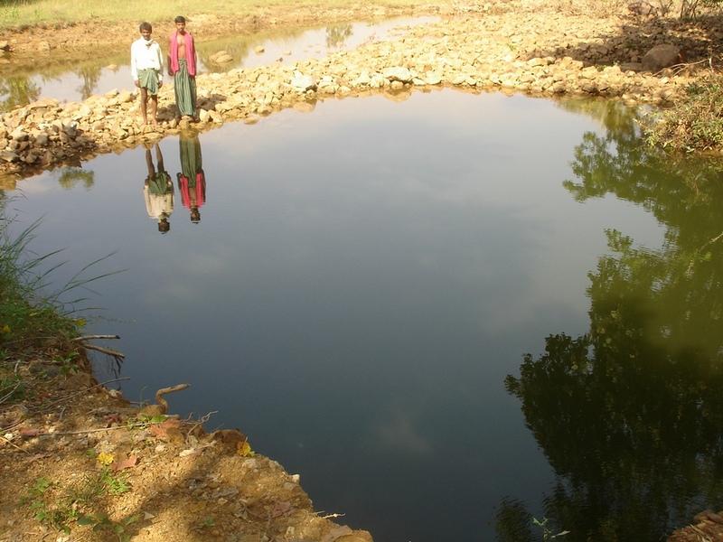
It can be defined as combination of structural & agronomic measures where along with other technology like Water harvesting structures & field bunding on the upper reaches & a dug out well is constructed in the periphery of the drainage line which is a govt land. The 15 acres of land near to its sphere of influence which reamained fallow earlier could yield good production system throughout the year.It is in the semi-arid climatic zone with moderate slope in medium soil depth conditions. The whole idea is to avail water & link with self-subsistance & market oriented production systems from private lands.
2.2 Технологийн дэлгэрэнгүй тайлбар
Тодорхойлолт:
The area is located at the foot-slopes on the major drainage line of the watershed. The technology area is located near the main drainage line, therefore, the sub-surface water availability is more & can be utilised for cultivation of crop even in dry spell of the year. Earlier the farmers near to this place tried to dig a small well & could irrigate for only 2-3 months of the year to get some subsistence crops. Therefore, water availability throughout the year is a first priority of the farmers. At the outset, a livelihood focused micro-plan had been prepared by the villagers stating the details of the base-line data along with problems & alternative solutions. The patch was identified to be the worst affected & the owners of the land are poor people (defined by villagers). Usually the land users used to migrate in search of labour due to loss in the agriculture. It is because the water availability is not there at the time of requirement. The people of this patch are ready to contribute at least 10% of the cost as the structure is to be constructed in government land. In the mean time the project sent the PIA to Water technology centre for eastern region, Bhubneswar to study the linking of water harvesting structure & dug-out well & its relevance in this context of our situation. The technology was done in the village Chareimara which is one out of 3 villages of one watershed, located at the lower reach of the watershed. In the meantime many water harvesting structures & field bunds were constructed due to which the water could be stored in the recharge zone. This area is again a mix of stony patches in the crop land. One water harvesting structure was constructed just at the upper reaches. The surrounding area was totally unbunded with clay loam soil. Therefore, land users are of opinion to go for a deeper dug well which can feed water through out to at least 15 acre of land. The requirement of land users was to get some water in each farmers land to protect the Kharif & rabi crop including summer vegetables. A four-day in field training was conducted by the project to community link workers (SWC), particularly on patch treatment, use of levelling instruments like A-frame, proper planning, design, lay-out of different type of structure in a map & ground. At the same time there was a blind belief that large water harvesting structures are more useful to farmers. So the land users demanded for a large WHS on the drainage bed which requires huge investment & high maintenance cost. But when some farmers of that watershed could get good result by digging well these land users also started thinking about a "community dug-well". After many rounds of discussion with the land users by the SWC specialist followed by a detail transact along with land users, the results of first round transact was mentioned in the micro-plan. But the aim behind subsequent transact was to looking at problems & demarcating on the map. After that estimate was prepared & lay-out of the well was done by SWC specialist with the help of community link workers & land users. The lay-out is also little bit different from traditional well i.e. square shaped in stead of round shape. The work was implemented by the land users & 7 outside labourers with the supervision of the User's group leader & monitoring was done by the SWC specialist. The priority by the land users was agronomic measures like changing the crop in the land. Training was conducted on the probable alternatives of agronomic measures like taking of crop which is of little longer duration, intercrops & cash crops etc. The structural measures are subsidised by the project & the agronomic measures was taken up on loan basis. The development fund was also generated out of contribution from the land users which was deposited in a separate account for future maintenance cost.
2.3 Технологийн гэрэл зураг
Медиа галерей

2.5 Энэ үнэлгээнд хамрагдсан технологийг хэрэгжүүлсэн улс орон / бүс нутаг / байршил
Улс :
Энэтхэг
Байршлын дэлгэрэнгүй тодорхойлолт:
Orissa, Balangir, Suktel/Mahanadi
Технологи өргөн дэлгэрсэн эсхийг тодорхойл:
- газар дээр жигд тархсан
Технологи газар нутгийн хэмжээнд жигд тархсан бол түүний эзлэх талбайг тодорхойлно уу (км2-аар):
0.6
Хэрэв талбайн хэмжээ тодорхойгүй бол талбайн хэмжээг ойролцоогоор тодорхойлно уу.
- 0.1-1 км2
Тайлбар:
Total area covered by the SLM Technology is 0.6 km2.
The concerned watershed is a subsidiary system of the Suktel river drainage sytem. The area of operation is micro watershed , i.e. 500 hac as a unit of the tributary of the Suktel river
Map
×2.6 Хэрэгжих огноо
Байгуулсан тодорхой оныг мэдэхгүй бол баримжаа хугацааг тодорхойл:
- <10 жилийн өмнө (саяхны)
2.7 Технологийн танилцуулга
Технологийг хэрхэн нэвтрүүлснийг тодорхойл:
- Гадны төсөл/хөтөлбөрийн дэмжлэгтэйгээр
Тайлбар (төслийн төрөл г.м.):
A group of SWC proffessionals were sent to WTCER, Bhubaneswar to study the replication of ' Linking of water harvesting structure with dug-out wells. . When SWC specialist share their experience to land users, some of the farmers agreed to have a experimentation of the technology. Therefore, modification has been done by the SWC specialists as per the suitability & requirement of the land users.
3. ГТМ технологийн ангилал
3.2 Технологи хэвтрүүлсэн газрын одоогийн газар ашиглалтын хэлбэр(д)

Тариалангийн газар
- Нэг наст үр тариа
- Олон наст (модлог биш) тариалан
Тариалан - Таримлыг тодорхойлно уу:
- хүнсний ногоо - гуа, хулуу, сквош эсвэл хулуу
- хүнсний ногоо - бусад
- хүнсний ногоо - үндсэрхэг ногоо (лууван, сонгино, хүрэн манжин, бусад)
- rice
Олон наст (модлог биш) тариалан - Таримлыг тодорхойлно уу:
- чихрийн нишэнгэ
Нэг жил дэх ургамал ургах улирлын тоо:
- 2
Тодорхойлно уу:
Longest growing period in days: 120Longest growing period from month to month: Jun - OctSecond longest growing period in days: 80Second longest growing period from month to month: Oct - Feb
Сөөлжлөн тариалалт хийгддэг үү?
Тийм
Хэрэв тийм бол ямар таримлыг сөөлжлөн тариалдаг вэ?
Mixed cropping / intercropping
Material/ species: Gourd, Brinjal, onion, sugarcane,water melon
Remarks: After the Kharif crop
Тайлбар:
Major land use problems (compiler’s opinion): This patch of the land used to remian fallow in comparison to other lands of the village, with high concentration of marginal farmer. Due to less water availability at the time of need of crop the farmers were quite hesitant to take up diversified crop. They used to migrated instead of taking up any agriculure due to loss year afte year. The main requirement of water throught out the year.
Major land use problems (land users’ perception): 1. Run-off was severe at the time of rainy season but difficult to capture water for other period of the year.2. Long duration crops is not possible, ex- paddy,pulses, sugarcane, vegetables etc. 3. Although land is there but it remained fallow in the past due to water availability. They were the migrants because of onstraint in agriculture.
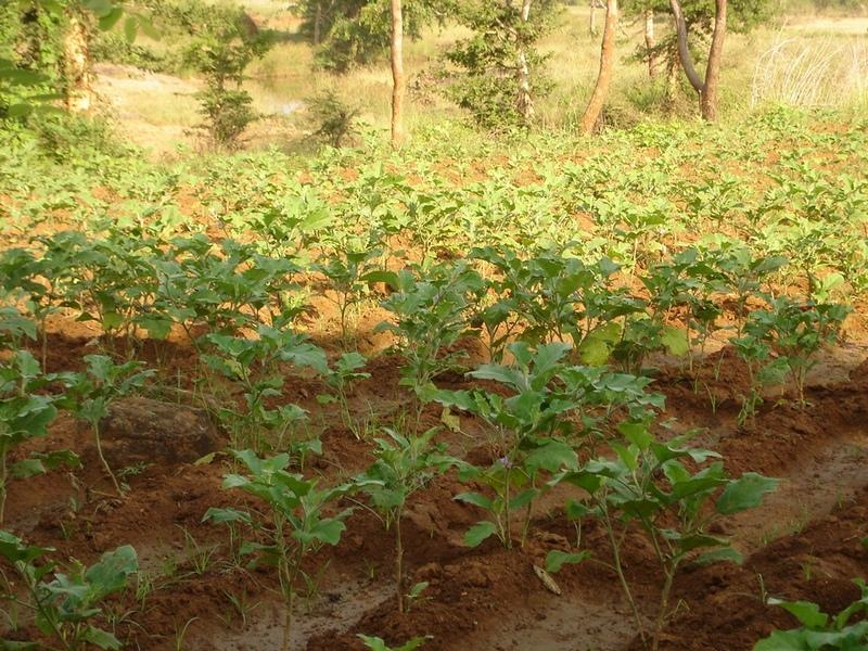
Type of cropping system and major crops comments: Paddy/Kharif rainfed vegetables, Winter vegetables & spices, summer vegetables. Gourd, Brinjal, onion, sugarcane,water melon
3.4 Усан хангамж
бусад (жишээ нь үерийн дараах):
- all of them
Тайлбар:
Water supply: rainfed, mixed rainfed - irrigated
3.6 Технологийг бүрдүүлэх ГТМ арга хэмжээ

Агрономийн арга хэмжээ
- А1: Ургамал/ хөрсөн бүрхэвч
- А2: Органик нэгдэл/ хөрсний үржил шим
- А5: Үрийн менежмент, сайжруулсан сорт
- А7: Бусад

Барилга байгууламжийн арга хэмжээ
Тайлбар:
Type of agronomic measures: better crop cover, early planting, mixed cropping / intercropping, manure / compost / residues, mineral (inorganic) fertilizers, rotations / fallows, breaking compacted topsoil, deep tillage / double digging
3.7 Технологийн шийдвэрлэсэн газрын доройтлын үндсэн төрлүүд

Хөрс усаар эвдрэх
- Wr: Голын эргийн эвдрэл
3.8 Газрын доройтлоос урьдчилан сэргийлэх, сааруулах ба нөхөн сэргээх
Газрын доройтолтой холбоотойгоор Технологи ямар зорилго тавьсан болохыг тодорхойл:
- Газрын доройтлоос урьдчилан сэргийлэх
- Хүчтэй доройтсон газрыг нөхөн сэргээх/ сайжруулах
Тайлбар:
reclamation of denuded land
4. Техникийн нөхцөл, хэрэгжилтийн үйл ажиллагаа, материал ба зардал
4.1 Технологийн техникийн зураг
Техник тодорхойлолт (техник зурагтай уялдана):
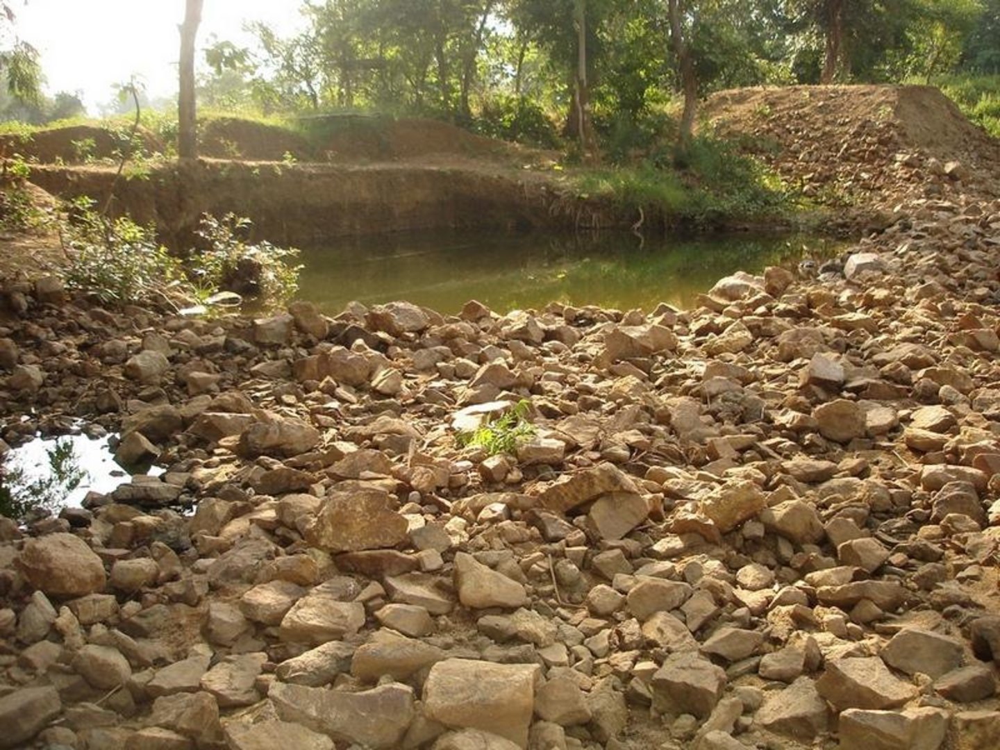
Dug Well in Chareimara
Technical knowledge required for field staff / advisors: low
Technical knowledge required for land users: low
Main technical functions: control of dispersed runoff: retain / trap, water harvesting / increase water supply
Secondary technical functions: control of concentrated runoff: impede / retard, water spreading
Better crop cover
Material/ species: paddy, vegetables,
Quantity/ density: Average
Remarks: Paddy for subsistence & vegetables in the land with rainfed & market demand.
Mixed cropping / intercropping
Material/ species: Gourd, Brinjal, onion, sugarcane,water melon
Quantity/ density: ealy harve
Remarks: After the Kharif crop
Manure / compost / residues
Material/ species: 4 -5 cartloads of cow-dung
Mineral (inorganic) fertilizers
Material/ species: Minimum basal doses
Rotations / fallows
Material/ species: the cultivation of crop started after the availability of water.
Remarks: Rainfed paddy with vegetables
Breaking compacted topsoil
Remarks: As the land was fallow earlier, breaking of compact soil is necessary.
Deep tillage / double digging
Remarks: The land where vegetables was grown, deep tillage was required
Structural measure: diversion ditch / cut-off drain
Depth of ditches/pits/dams (m): 26ft
Width of ditches/pits/dams (m): 35ft
Length of ditches/pits/dams (m): 33ft
Construction material (stone): Stone excavetd from the well was put as protection embankment
Construction material (concrete): A concrete guard wall will be put on the periphery of well which will be started in the current year
For water harvesting: the ratio between the area where the harvested water is applied and the total area from which water is collected is: 1:150
Change of land use type: After paddy & kharif vegetables,rabi & summer vegetables .Th e bunds of the patch need to be covered with plants
Change of land use practices / intensity level: Inter crops, mixed crops have to be practiced to get optimum benefit.
Layout change according to natural and human environment: Grazing was restricted in these areas & land was optimally used, like bund cultivation.
Major change in timing of activities: Early varieties of vegetables will fetch at least double benefit.
Control / change of species composition: The improved varities seed need to be introduced
4.2 Материал болон зардалд хамаарах ерөнхий мэдээлэл
бусад/үндэсний мөнгөн нэгж (тодорхойл):
Rupee
Хэрэв боломжтой бол үндэсний валютын Америк доллартай харьцах харьцааг бичнэ үү (тухайлбал, 1 ам.дол. = 79,9 Бразил реал): 1 ам.дол. =:
50.0
Хөлсний ажилчны нэг өрдийн ажлын хөлсийг тодорхойл:
1.00
4.3 Байгуулах үйл ажиллагаа
| Үйл ажиллагаа | Хугацаа (улирал) | |
|---|---|---|
| 1. | Survey | April-May |
| 2. | Demarkation on map | April-May |
| 3. | Estimate & lay-Out | April-May |
| 4. | Implementation of work | May-July |
| 5. | Survey & demarkation of water line | April |
| 6. | Digging of well | May-July |
| 7. | Water-way | August |
4.4 Байгуулалтад шаардагдах зардал ба материал
| Хөрөнгө оруулалтыг дурьдана уу | Хэмжих нэгж | Тоо хэмжээ | Нэгжийн өртөг | Материал бүрийн нийт өртөг | % газар ашиглачаас гарсан зардал | |
|---|---|---|---|---|---|---|
| Хөдөлмөр эрхлэлт | Medium | hectare | 1.0 | 1250.0 | 1250.0 | |
| Технологи бий болгох нийт үнэ өртөг | 1250.0 | |||||
| Технологи бий болгох нийт үнэ өртөг, ам.доллар | 25.0 | |||||
Тайлбар:
Duration of establishment phase: 24 month(s)
4.5 Засвар үйлчилгээ / давтагдах үйл ажиллагаа
| Үйл ажиллагаа | Хугацаа/ давтамж | |
|---|---|---|
| 1. | Ploughing | April-May / |
| 2. | Intercultural operation with manure & compost application | June / |
| 3. | Sowing of paddy & rainfed vegetables | July & sep for two crops / |
| 4. | weeding & intercultural operation, if required. | July / |
| 5. | Harvesting of paddy orvegetables or sugarcane. | Nov / |
| 6. | Winter early variety vegetables like onion, brinjal, leafy vegetables, gourds etc. | Dec / |
| 7. | Harvesting of winter spices & vegetables | Feb-March / |
| 8. | Sowing of summer vegetables like water melon etc | March / |
| 9. | Intercultural operation | April / |
| 10. | Harvesting of vegetables | May / |
| 11. | Management of surplus water | Rainy Season/annual |
| 12. | Collapsing of bund | annual |
| 13. | Well must be desilted | Dry season/each cropping season |
| 14. | Control of surplus water-flow | August-Sep / annual |
| 15. | Stabilisation of bund at weak points | Nov-Dec / annual |
| 16. | Desiltation of well | April-may / annual |
4.7 Зардалд нөлөөлж байгаа хамгийн чухал хүчин зүйл
Өртөг зардлыг тодорхойлох гол хүчин зүйлсийг дурьдана уу:
Stones are to be excavated from such a height of 26 ft.
5. Хүн, байгалийн хүрээлэн буй орчин
5.1 Уур амьсгал
Жилийн нийлбэр хур тундас
- <250 мм
- 251-500 мм
- 501-750 мм
- 751-1,000 мм
- 1,001-1,500 мм
- 1,501-2,000 мм
- 2,001-3,000 мм
- 3,001-4,000 мм
- > 4,000 мм
Агро-уур амьсгалын бүс
- Хагас чийглэг
- Хагас хуурай
5.2 Байрзүйн зураг
Дундаж налуу:
- Тэгш (0-2 %)
- Бага зэрэг хэвгий (3-5 %)
- Дунд зэрэг хэвгий (6-10 % )
- Долгиорхог (11-15 %)
- Толгодорхог (16-30 %)
- Эгц налуу (31-60 % )
- Огцом эгц налуу (>60 %)
Гадаргын хэлбэр:
- Тэгш өндөрлөг/тэгш тал
- Зоо, хяр
- Уулын энгэр, хажуу
- Ухаа, гүвээ, дов толгод
- Уулын бэл
- Хөндий, хоолой, нам хотос
Өндөршлийн бүс:
- 0-100 м д.т.д
- 101-500 м д.т.д
- 501-1,000 м д.т.д
- 1,001-1,500 м д.т.д
- 1,501-2,000 м д.т.д
- 2,001-2,500 м д.т.д
- 2,501-3,000 м д.т.д
- 3,001-4,000 м д.т.д
- > 4,000 м д.т.д
5.3 Хөрс
Хөрсний дундаж зузаан:
- Маш нимгэн (0-20 см)
- Нимгэн (21-50 см)
- Дунд зэрэг зузаан (51-80 см)
- Зузаан (81-120 cм)
- Маш зузаан (>120 cм)
Хөрсний бүтэц (өнгөн хөрс):
- Дунд зэрэг (шавранцар)
- Хүнд (шаварлаг)
Өнгөн хөрсний органик нэгдэл:
- Дунд (1-3 % )
- Бага (<1 % )
5.6 Технологи нэвтрүүлсэн газар ашиглагчидын онцлог шинж
Үйлдвэрлэлийн системийн зах зээлийн чиг баримжаа:
- Амь зуух арга хэлбэрийн (өөрийгөө хангах)
- Худалдаа наймааны/ зах зээлийн
Фермээс гадуурх орлого:
- Нийт орлогын %10 доош хувь
Чинээлэг байдлыг харьцангуй түвшин:
- Нэн ядуу
- Ядуу
Механикжилтын түвшин:
- Хүнд хүчир ажил
- Амьтны зүтгүүр
Газар ашиглагчдын бусад шаардлагатай шинж чанарыг тодорхойл:
1% of the land users are poor (2-3 acres of land).
Off-farm income specification: Others have also activities like NTFP collection, keeping small ruminants like goats, chicks etc.
5.7 Технологи нэвтрүүлэхэд газар ашиглагчийн ашигласан газрын дундаж талбай
- < 0.5 га
- 0.5-1 га
- 1-2 га
- 2-5 га
- 5-15 га
- 15-50 га
- 50-100 га
- 100-500 га
- 500-1,000 га
- 1,000-10,000 га
- > 10,000 га
Тайлбар:
Average area of land owned or leased by land users applying the Technology: 0.5-1 ha, 0.5-1 ha, 1-2 ha, 1-2 ha
5.8 Газар эзэмшил, газар ашиглах эрх, ус ашиглах эрх
Газар өмчлөл:
- Хувь хүн, цол эргэм бүхий
Газар ашиглах эрх:
- Хувь хүн
6. Үр нөлөө ба дүгнэлт
6.1 Технологийн талбай дахь үр нөлөө
Нийгэм-эдийн засгийн үр нөлөө
Үйлдвэрлэл
Газар тариалангийн үйлдвэрлэл
Орлого, зарлага
тариалангийн газрын орлого
Нийгэм-соёлын үр нөлөө
олон нийтийн институц
маргааныг шийдвэрлэх
Экологийн үр нөлөө
Усны эргэлт/ илүүдэл
илүүдэл ус урсгах
6.2 Технологийн талбайн гадна үзүүлсэн үр нөлөө
хуурай улиралд ашиглах найдвартай, тогтвортой урсгал
6.4 Зардал ба үр ашгийн шинжилгээ
Үр ашгийг барилга байгууламжийн зардалтай (газар ашиглагчдын үзэл бодлоор) хэрхэн харьцуулах вэ?
Богино хугацаанд эргэн төлөгдөх байдал:
Дунд зэрэг
Урт хугацаанд эргэн төлөгдөх байдал:
Маш эерэг
Үр ашгийг засвар үйлчилгээ/ урсгал зардалтай (газар ашиглагчдын үзэл бодлоор) хэрхэн харьцуулах вэ?
Богино хугацаанд эргэн төлөгдөх байдал:
Бага зэрэг сөрөг
Урт хугацаанд эргэн төлөгдөх байдал:
Бага зэрэг эерэг
6.5 Технологи нутагшуулах
Тайлбар:
100% of land user families have adopted the Technology with external material support
10 land user families have adopted the Technology with external material support
Comments on acceptance with external material support: survey results
6.7 Технологийн давуу тал/боломжууд
| Газар ашиглагчдын тодорхойлсон давуу тал/боломжууд |
|---|
| Water availilbilty |
| A vibrant community institution could be strngthed. |
| A well is much better than a large water harvesting structure, it became a eye opener in the surrounding villages. |
| Эмхэтгэгч, бусад мэдээлэл өгсөн хүмүүсийн өнцгөөс тодорхойлсон давуу тал/боломжууд |
|---|
|
Water availability in the dry spell How can they be sustained / enhanced? Integrated & threes season land use practice |
| The water availability will be there through out the year.Therefore, 15 acres of land can be irrigated & three seasonal crop can be taken up. |
7. Ном зүй ба холбоосууд
7.1 Мэдээллийн аргууд / эх сурвалжууд
Холбоос ба модулууд
Бүгдийг харуулах Бүгдийг хаахХолбоосууд
Холбоос байхгүй байна
Модулууд
Модуль байхгүй байна