Ex-post and ex-ante soil sealing maps [ប្រទេសប៉ូឡូញ]
- ការបង្កើត៖
- បច្ចុប្បន្នភាព
- អ្នកចងក្រង៖ Tomasz Miturski
- អ្នកកែសម្រួល៖ –
- អ្នកត្រួតពិនិត្យច្រើនទៀត៖ Fabian Ottiger, Alexandra Gavilano
Mapy procesu zasklepiania gleb (Polish)
technologies_1716 - ប្រទេសប៉ូឡូញ
ពិនិត្យមើលគ្រប់ផ្នែក
ពង្រីកមើលទាំងអស់ បង្រួមទាំងអស់1. ព័ត៌មានទូទៅ
1.2 ព័ត៌មានលម្អិតពីបុគ្គលសំខាន់ៗ និងស្ថាប័នដែលចូលរួមក្នុងការវាយតម្លៃ និងចងក្រងឯកសារនៃបច្ចេកទេស
ឈ្មោះគម្រោងដែលបានចងក្រងឯកសារ/ វាយតម្លៃលើបច្ចេកទេស (បើទាក់ទង)
Preventing and Remediating degradation of soils in Europe through Land Care (EU-RECARE )ឈ្មោះអង្គភាពមួយ (ច្រើន) ដែលបានចងក្រងឯកសារ/ វាយតម្លៃបច្ចេកទេស (បើទាក់ទង)
Institute of Soil Science and Plant Cultivation (Institute of Soil Science and Plant Cultivation) - ប្រទេសប៉ូឡូញ1.3 លក្ខខណ្ឌទាក់ទងទៅនឹងការប្រើប្រាស់ទិន្នន័យដែលបានចងក្រងតាមរយៈ វ៉ូខេត
អ្នកចងក្រង និង(បុគ្គលសំខាន់ៗ)យល់ព្រមទទួលយកនូវលក្ខខណ្ឌនានាទាក់ទងទៅនឹងការប្រើប្រាស់ទិន្នន័យដែលបានចងក្រងតាមរយៈវ៉ូខេត:
បាទ/ចា៎
1.4 សេចក្តីប្រកាសស្តីពីចីរភាពនៃការពណ៌នាពីបច្ចេកទេស
តើបច្ចេកទេសដែលបានពណ៌នានេះមានបញ្ហាដែលផ្តោតលើការធ្លាក់ចុះគុណភាពដី, បើដូច្នេះវាមិនអាចត្រូវបានប្រកាសថាជាបច្ចេកទេសនៃការគ្រប់គ្រងប្រកបដោយចីរភាពទេ?
ទេ
1.5 ការយោងទៅលើកម្រងបញ្ជីសំណួរ (មួយ ឬច្រើន) នៃវិធីសាស្ត្រផ្សព្វផ្សាយ SLM (ដែលបានចងក្រងដោយទស្សនៈពិភពលោកស្តីពីវិធីសាស្ត្រ និងបច្ចេកទេសងអភិរក្ស WOCAT)

The prevention of soil sealing [ប្រទេសប៉ូឡូញ]
The prevention of soil sealing is an approach in which stakeholders are making spatial planning decisions based on the new map of soil sealing, in case of protecting the most valuable soils.
- អ្នកចងក្រង៖ Tomasz Miturski
2. ការពណ៌នាពីបច្ចេកទេស SLM
2.1 ការពណ៌នាដោយសង្ខេបពីបច្ចេកទេស
និយមន័យបច្ចេកទេស:
Ex-post and ex-ante soil sealing maps
2.2 ការពណ៌នាលម្អិតពីបច្ចេកទេស
ការពណ៌នា:
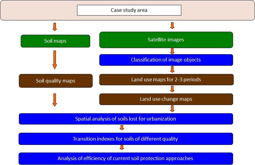
The technology utilizes soil agricultural maps and provides information on quality of sealed soils.
It involves cellular automata software to build the model of land use change and produce the forecasts for various soil protection scenarios.
Spatial development of the functional areas. These are mostly areas of soil protection for food production purposes. The delineation is based on land productivity information (present on soil-agricultural maps), distribution of high nature value areas, need for establishment of “green rings” around the bigger cities.
The maps will be sent to the municipal authorities, with a scientific comment on the problem. The technology enables determining the scale of the soil sealing threat in the province, also what is the soil quality class of the area of interest. In the municipalities with the greatest soil sealing problem and with perspective to expand in the future, there is a need for new legal regulations to force soil protection in local spatial plans. The regional spatial planning office should become a coordinator for the local spatial planning offices, to raise the knowledge about how to use soil digital maps in spatial planning, especially in the case of protecting the soil against soil sealing process. For the municipalities, large scale maps are produced, which contain results of soil sealing forecasting model.
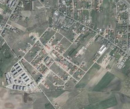
Land use maps of at least 10-meter resolution are produced for two historical periods through classification of the satellite images and using available local land use information. The information on land use change is superimposed on maps characterizing soil quality in order to detect to what extend the urbanization took place on valuable soils. The new sealed area, reflecting the built up sprawl of at least last 15 years, consists with expansion of the following land use classes: continuous residential area, commercial/industrial area and transport facilities. The soils under these new land use types fully lost their environmental functions.
In the soil sealing forecasts the Cellular Automata-based Metronamica model is used. The software was developed and provided by the Research Institute from Knowledge Systems (RIKS) from Maastricht, The Netherlands. The software utilizes cellular automata model to spatially distribute areas of particular land use classes with assumption that the neighborhood of a cell (surrounding cells) influences the transition of this cell into other land use class in the next time step. The method utilizes land use maps and soil quality maps.
2.3 រូបភាពនៃបច្ចេកទេស
វិចិត្រសាលប្រព័ន្ធផ្សព្វផ្សាយ
2.5 ប្រទេស/តំបន់/ទីតាំងកន្លែង ដែលបច្ចេកទេសត្រូវបានអនុវត្ត និងបានគ្រប់ដណ្តប់ដោយការវាយតម្លៃនេះ
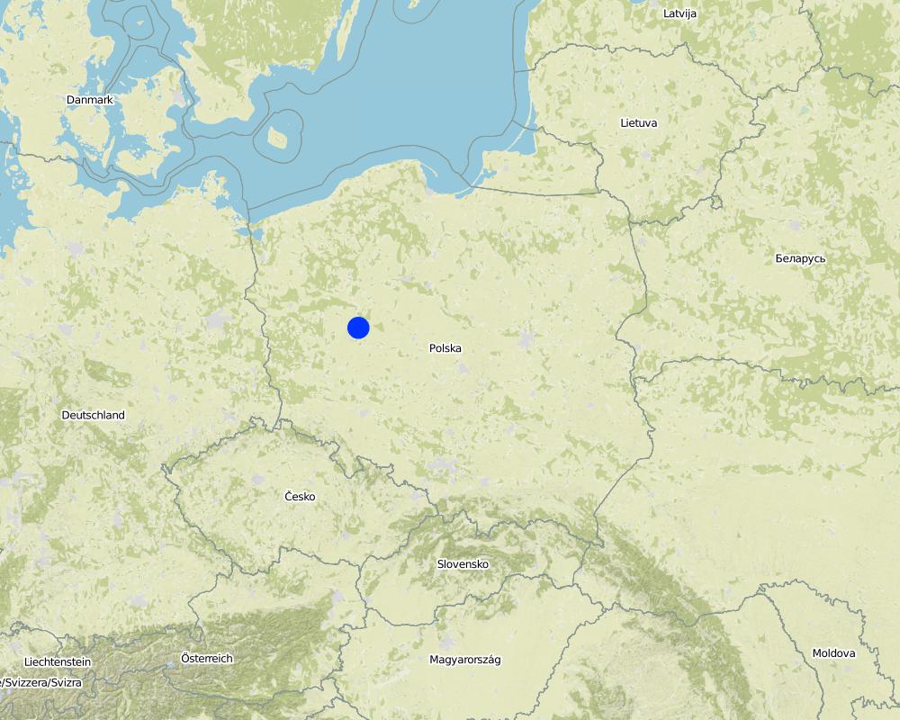
ប្រទេស:
ប្រទេសប៉ូឡូញ
តំបន់/រដ្ឋ/ខេត្ត:
Poland/Great Poland province
បញ្ជាក់បន្ថែមពីលក្ខណៈនៃទីតាំង:
Poznań
បញ្ជាក់ពីការសាយភាយនៃបច្ចេកទេស:
- ត្រូវបានផ្សព្វផ្សាយត្រឹមតំបន់មួយ
ប្រសិនបើបច្ចេកទេសត្រូវបានសាយភាយពាសពេញតំបន់ណាមួយ បញ្ជាក់ទំហំផ្ទៃដីអនុវត្តន៍ (គិតជា គ.ម2):
199,0
ប្រសិនបើមិនច្បាស់ពីទំហំផ្ទៃដី សូមធ្វើការប៉ាន់ប្រម៉ាណ:
- 100-1,000 គម2
មតិយោបល់:
Total area covered by the SLM Technology is 199 km2.
Map
×2.6 កាលបរិច្ឆេទនៃការអនុវត្ត
ប្រសិនបើមិនច្បាស់ឆ្នាំ សូមបញ្ជាក់កាលបរិច្ឆេទដែលប្រហាក់ប្រហែល:
- តិចជាង 10ឆ្នាំមុន (ថ្មី)
2.7 ការណែនាំពីបច្ចេកទេស
សូមបញ្ជាក់តើបច្ចេកទេសត្រូវបានណែនាំឱ្យអនុវត្តដោយរបៀបណា:
- ពេលកំពុងពិសោធន៍
- តាមរយៈគម្រោង / អន្តរាគមន៍ពីខាងក្រៅ
3. ចំណាត់ថ្នាក់នៃបច្ចេកទេស SLM
3.1 គោលបំណងចម្បង (១ ឬច្រើន) នៃបច្ចេកទេសនេះ
- បង្កើតផលប្រយោជន៍សេដ្ឋកិច្ច
- បង្កើតផលប្រយោជន៍សង្គម
- Create and spread knowledge
3.2 ប្រភេទដីប្រើប្រាស់មួយប្រភេទ (ច្រើនប្រភេទ) ដែលបានអនុវត្តបច្ចេកទេស

ដីដាំដំណាំ
- ដំណាំប្រចាំឆ្នាំ
ចំនួនសារដែលដាំដំណាំក្នុងមួយឆ្នាំ:
- 1
សូមបញ្ជាក់:
Longest growing period in days: 215, Longest growing period from month to month: April - October

ដីសម្រាប់ចិញ្ចឹមសត្វ
មតិយោបល់:
Major land use problems (compiler’s opinion): Preferential sealing of most productive soils.
3.5 ក្រុម SLM ដែលបច្ចេកទេសស្ថិតនៅក្នុង
- កាត់បន្ថយហានិភ័យនៃបញ្ហាលើប្រព័ន្ធអេកូឡូស៊ី
- Creating and sharing knowledge
3.6 វិធានការ SLM ដែលបញ្ចូលនូវបច្ចេកទេស

វិធានការគ្រប់គ្រង
- M2: ការផ្លាស់ប្តូរការគ្រប់គ្រង/ កម្រិតអាំងតង់ស៊ីតេ
3.7 កំណត់ប្រភេទនៃការធ្លាក់ចុះគុណភាពដីសំខាន់ៗដែលបច្ចេកទេសនេះបានដោះស្រាយ

ការបាត់បង់រូបសាស្ត្រនៃដី
- Pu: បាត់បង់នូវផលិតភាពជីវៈដោយសារសកម្មភាពផ្សេងៗ
មតិយោបល់:
Main causes of degradation: urbanisation and infrastructure development, population pressure, governance / institutional
Secondary causes of degradation: inputs and infrastructure: (roads, markets, distribution of water points, other, …)
3.8 ការពារ កាត់បន្ថយ ឬស្តារឡើងវិញនៃការធ្លាក់ចុះគុណភាពដី
បញ្ជាក់ពីគោលដៅរបស់បច្ចេកទេស ដែលផ្តោតទៅការធ្លាក់ចុះគុណភាពដី:
- ការការពារការធ្លាក់ចុះគុណភាពដី
- ការកាត់បន្ថយការធ្លាក់ចុះគុណភាពដី
4. បច្ចេកទេសជាក់លាក់ សកម្មភាពអនុវត្ត ធាតុចូល និងថ្លៃដើម
4.1 គំនូសបច្ចេកទេសនៃបច្ចេកទេសនេះ
លក្ខណៈពិសេសនៃបច្ចេកទេស (ទាក់ទងនឺងគំនូរបច្ចេកទេស):
This is a schema for soil sealing maps developement.
Technical knowledge required for land users: moderate (Developers)
Technical knowledge required for Administration: high
Technical knowledge required for Researchers: high
Main technical functions: improvement of surface structure (crusting, sealing), increase of infiltration, spatial arrangement and diversification of land use
Secondary technical functions: improvement of water quality, buffering / filtering water
Change of land use type: Limited conversion of agricultural land into urban purposes.
Change of land use practices / intensity level: Steering new constructions to soils with less functions. Limited sealing of high quality soils.
5. លក្ខណៈបរិស្ថានធម្មជាតិ និងមនុស្ស
5.1 អាកាសធាតុ
បរិមាណទឹកភ្លៀងប្រចាំឆ្នាំ
- < 250 មម
- 251-500 មម
- 501-750 មម
- 751-1,000 មម
- 1,001-1,500 មម
- 1,501-2,000 មម
- 2,001-3,000 មម
- 3,001-4,000 មម
- > 4,000 មម
តំបន់កសិអាកាសធាតុ
- មានភ្លៀងមធ្យម
Thermal climate class: temperate
5.2 សណ្ឋានដី
ជម្រាលជាមធ្យម:
- រាបស្មើ (0-2%)
- ជម្រាលតិចតួច (3-5%)
- មធ្យម (6-10%)
- ជម្រាលខ្ពស់បន្តិច (11-15%)
- ទីទួល (16-30%)
- ទីទួលចោត (31-60%)
- ទីទួលចោតខ្លាំង (>60%)
ទម្រង់ដី:
- ខ្ពង់រាប
- កំពូលភ្នំ
- ជម្រាលភ្នំ
- ជម្រាលទួល
- ជម្រាលជើងភ្នំ
- បាតជ្រលងភ្នំ
តំបន់តាមរយៈកម្ពស់ :
- 0-100 ម
- 101-500 ម
- 501-1,000 ម
- 1,001-1,500 ម
- 1,501-2,000 ម
- 2,001-2,500 ម
- 2,501-3,000 ម
- 3,001-4,000 ម
- > 4,000 ម
បញ្ជាក់ថាតើបច្ចេកទេសនេះត្រូវបានអនុវត្តន៍នៅក្នុង:
- មិនពាក់ព័ន្ធទាំងអស់
5.3 ដី
ជម្រៅដីជាមធ្យម:
- រាក់ខ្លាំង (0-20 សម)
- រាក់ (21-50 សម)
- មធ្យម (51-80 សម)
- ជ្រៅ (81-120 សម)
- ជ្រៅខ្លាំង (> 120 សម)
វាយនភាពដី (ស្រទាប់លើ):
- មធ្យម (ល្បាយ, ល្បាប់)
សារធាតុសរីរាង្គនៅស្រទាប់ដីខាងលើ:
- មធ្យម (1-3%)
បើអាចសូមភ្ជាប់ការពណ៌នាពីដីឱ្យបានច្បាស់ ឬព័ត៌មានដែលអាចទទួលបាន ឧ. ប្រភេទដី, pH ដី/ ជាតិអាស៊ីត, សមត្ថភាពផ្លាស់ប្តូរកាចុង, វត្តមាននីត្រូសែន, ភាពប្រៃ ។ល។:
Soil fertility: High
Soil drainage/infiltration: Medium (ranked 1) and poor (ranked 2)
Soil water storage capacity: Medium
5.4 ទឹកដែលអាចទាញមកប្រើប្រាស់បាន និងគុណភាពទឹក
នីវ៉ូទឹកក្រោមដី:
< 5 ម
ទឹកលើដីដែលអាចទាញយកប្រើប្រាស់បាន:
ល្អ
5.6 លក្ខណៈនៃអ្នកប្រើប្រាស់ដីដែលអនុវត្តបច្ចេកទេស
ទីផ្សារនៃប្រព័ន្ធផលិតកម្ម:
- ពាក់កណ្តាលពាណិជ្ជកម្ម (ផ្គត់ផ្គង់ខ្លួនឯង/ ពាណិជ្ជកម្ម)
ឯកជន ឬក្រុម:
- មានបុគ្គលិក (ក្រុមហ៊ុន, រដ្ឋ)
សូមបញ្ជាក់ពីលក្ខណៈពាក់ព័ន្ធផ្សេងទៀតអំពីអ្នកប្រើប្រាស់ដី:
Population density: > 500 persons/km2
5.7 ទំហំផ្ទៃដីជាមធ្យមនៃដីប្រើប្រាស់ដោយអ្នកប្រើប្រាស់ដី ក្នុងការអនុវត្តបច្ចេកទេស
- < 0.5 ហិកតា
- 0.5-1 ហិកតា
- 1-2 ហិកតា
- 2-5 ហិកតា
- 5-15 ហិកតា
- 15-50 ហិកតា
- 50-100 ហិកតា
- 100-500 ហិកតា
- 500-1,000 ហិកតា
- 1,000-10,000 ហិកតា
- > 10,000 ហិកតា
តើផ្ទៃដីនេះចាត់ទុកជាទំហំកម្រិតណាដែរ ខ្នាតតូច មធ្យម ឬខ្នាតធំ (ធៀបនឹងបរិបទតំបន់)?
- ខ្នាតធំ
5.8 ភាពជាម្ចាស់ដី កម្មសិទ្ធប្រើប្រាស់ដី និងកម្មសិទ្ធប្រើប្រាស់ទឹក
ភាពជាម្ចាស់ដី:
- ឯកជន មានកម្មសិទ្ធ
កម្មសិទ្ធិប្រើប្រាស់ដី:
- ឯកជន
5.9 ការប្រើប្រាស់សេវាកម្ម និងហេដ្ឋារចនាសម្ព័ន្ធ
សុខភាព:
- មិនល្អ
- មធ្យម
- ល្អ
ការអប់រំ:
- មិនល្អ
- មធ្យម
- ល្អ
ជំនួយបច្ចេកទេស:
- មិនល្អ
- មធ្យម
- ល្អ
ការងារ (ឧ. ការងារក្រៅកសិដ្ឋាន):
- មិនល្អ
- មធ្យម
- ល្អ
ទីផ្សារ:
- មិនល្អ
- មធ្យម
- ល្អ
ថាមពល:
- មិនល្អ
- មធ្យម
- ល្អ
ផ្លូវ និងការដឹកជញ្ជូន:
- មិនល្អ
- មធ្យម
- ល្អ
ទឹកផឹក និងអនាម័យ:
- មិនល្អ
- មធ្យម
- ល្អ
សេវាកម្មហិរញ្ញវត្ថុ:
- មិនល្អ
- មធ្យម
- ល្អ
6. ផលប៉ះពាល់ និងការសន្និដ្ឋាន
6.1 ផលប៉ះពាល់ក្នុងបរិវេណអនុវត្តបច្ចេកទេសដែលកើតមាន
ផលប៉ះពាល់លើសេដ្ឋកិច្ចសង្គម
ផលិតផល
ផលិតកម្មចំណីសត្វ
មតិយោបល់/ ការបញ្ជាក់:
comparing to baseline scenario
ផ្ទៃដីផលិតកម្ម
មតិយោបល់/ ការបញ្ជាក់:
comparing to baseline scenario
ទឹកដែលអាចទាញមកប្រើប្រាស់បាន និងគុណភាពទឹក
ទឹកប្រើប្រាស់សម្រាប់ស្រោចស្រព
មតិយោបល់/ ការបញ្ជាក់:
comparing to baseline scenario
គុណភាពទឹកស្រោចស្រព
មតិយោបល់/ ការបញ្ជាក់:
comparing to baseline scenario
ផលប៉ះពាល់ទៅលើវប្បធម៌សង្គម
សន្តិសុខស្បៀង/ ភាពគ្រប់គ្រាន់ខ្លួនឯង
មតិយោបល់/ ការបញ្ជាក់:
comparing to baseline scenario
ឱកាសនៃការបង្កើតថ្មី
មតិយោបល់/ ការបញ្ជាក់:
comparing to baseline scenario
ចំណេះដឹង SLM / ការធ្លាក់ចុះគុណភាពដី
ផលប៉ះពាល់ទៅលើអេកូឡូស៊ី
វដ្តទឹក/លំហូរ
លំហូរទឹកលើផ្ទៃដី
ដី
ការបាត់បង់ដី
ដីប្រេះ
ដីហាប់
ជីវចម្រុះ៖ ដំណាំ, សត្វ
ភាពសម្បូរបែបនៃទីជំរក
6.2 ផលប៉ះពាល់ក្រៅបរិវេណអនុវត្តបច្ចេកទេសដែលកើតមាន
ទឹកដែលអាចទាញមកប្រើប្រាស់បាន
ទឹកជំនន់ខ្សែទឹកខាងក្រោម
6.5 ការទទួលយកបច្ចេកទេស
មតិយោបល់:
There are examples of land use and soil maps for spatial planing in cities of Central Europe, e.g. Stuttgart. it is impossible to assess the percentage of users.
6.7 ភាពខ្លាំង/ គុណសម្បត្តិ/ ឱកាសនៃបច្ចេកទេស
| ភាពខ្លាំង/ គុណសម្បត្តិ/ ឱកាស ទស្សនៈរបស់បុគ្គលសំខាន់ៗ |
|---|
| Analysis of various scenarios possible |
| Decisions in spatial planning based on empirical data in spatial format |
6.8 ភាពខ្សោយ/ គុណវិបត្តិ/ ហានិភ័យនៃបច្ចេកទេស និងវិធីសាស្ត្រដោះស្រាយ
| ភាពខ្សោយ/ គុណវិបត្តិ/ ហានិភ័យ ទស្សនៈរបស់អ្នកចងក្រងឬបុគ្គលសំខាន់ៗ | តើបច្ចេកទេសទាំងនោះបានដោះស្រាយបញ្ហាដូចម្តេច? |
|---|---|
| Lack of regulations forcing use of the technology | Pressenting examples of implementation in order to encourage to apply at local level strategies |
| Potential errors in forecasts | Improving the data quality and model effectiveness. |
7. ឯកសារយោង និងវេបសាយ
7.1 វិធីសាស្ត្រ/ ប្រភពនៃព័ត៌មាន
- តាមការចុះទីវាល ការស្រាវជ្រាវនៅទីវាល
- ការសម្ភាសន៍ជាមួយអ្នកប្រើប្រាស់ដី
តើពេលណាដែលទិន្នន័យបានចងក្រង (នៅទីវាល)?
28/02/2015
ការតភ្ជាប់ និងម៉ូឌុល
ពង្រីកមើលទាំងអស់ បង្រួមទាំងអស់ការតភ្ជាប់
The prevention of soil sealing [ប្រទេសប៉ូឡូញ]
The prevention of soil sealing is an approach in which stakeholders are making spatial planning decisions based on the new map of soil sealing, in case of protecting the most valuable soils.
- អ្នកចងក្រង៖ Tomasz Miturski
ម៉ូឌុល
គ្មានម៉ូឌុល