Water run-off control plan on cultivated land [ອາຟິກກາໃຕ້]
- ການສ້າງ:
- ປັບປູງ:
- ຜູ້ສັງລວມຂໍ້ມູນ: Carin Pretorius
- ບັນນາທິການ: –
- ຜູ້ທົບທວນຄືນ: Alexandra Gavilano
Watercourses and contours
technologies_956 - ອາຟິກກາໃຕ້
ເບິ່ງພາກສ່ວນ
ຂະຫຍາຍທັງໝົດ ຍຸບທັງໝົດ1. ຂໍ້ມູນທົ່ວໄປ
1.3 ເງື່ອນໄຂ ກ່ຽວກັບ ການນໍາໃຊ້ຂໍ້ມູນເອກະສານ ທີ່ສ້າງຂື້ນ ໂດຍຜ່ານ ອົງການພາບລວມຂອງໂລກ ທາງດ້ານແນວທາງ ແລະ ເຕັກໂນໂລຢີ ຂອງການອານຸລັກ ທໍາມະຊາດ (WOCAT)
ເມື່ອໃດທີ່ໄດ້ສັງລວມຂໍ້ມູນ (ຢູ່ພາກສະໜາມ)?
01/06/1999
ຜູ້ປ້ອນຂໍ້ມູນ ແລະ ບຸກຄົນສຳຄັນ ທີ່ໃຫ້ຂໍ້ມູນ (ຫຼາຍ) ຍິນຍອມ ຕາມເງື່ອນໄຂ ໃນການນຳໃຊ້ຂໍ້ມູນ ເພື່ອສ້າງເປັນເອກກະສານຂອງ WOCAT:
ແມ່ນ
2. ການອະທິບາຍ ເຕັກໂນໂລຢີ ຂອງການຄຸ້ມຄອງ ທີ່ດິນແບບຍືນຍົງ
2.1 ຄໍາອະທິບາຍສັ້ນຂອງ ເຕັກໂນໂລຢີ
ການກຳໜົດຄວາມໝາຍ ຂອງເຕັກໂນໂລຢີ:
Artificially built watercourses with contour banks with a specific gradient
2.2 ການອະທິບາຍ ລາຍລະອຽດ ຂອງເຕັກໂນໂລຢີ
ການພັນລະນາ:
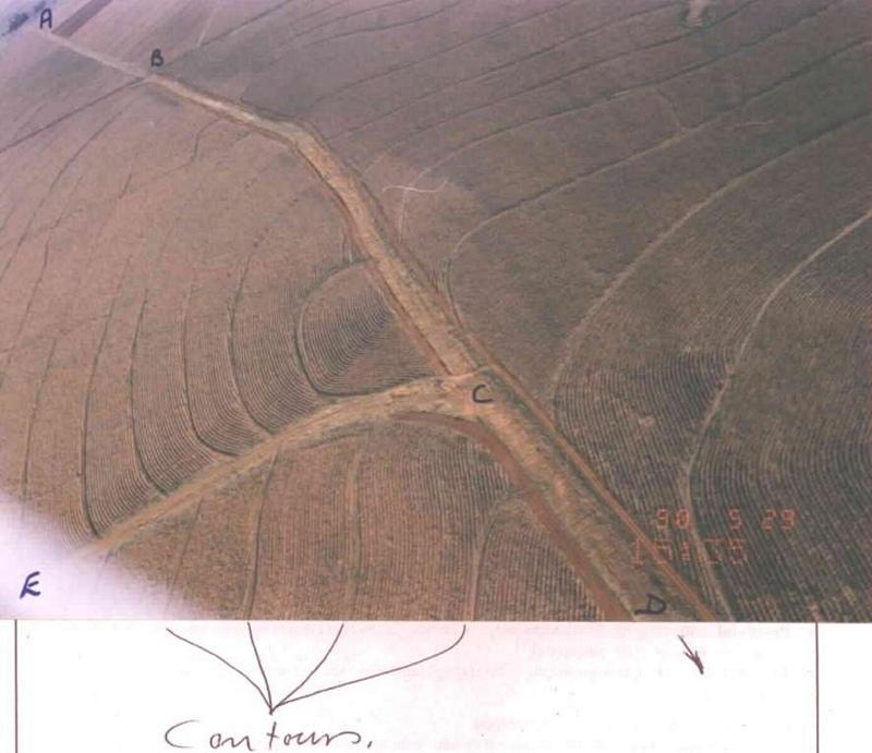
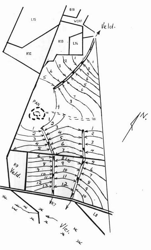
Watercourse: According to the topography, one or two watercourses are needed to drain any excess run-off water during high rainfall intensities. A watercourse is built directly downhill. A perennial grass adapted to the specific environment is established in the watercourses. Maintenance requires that the grass must be fertilised according to the climate of the area. Regular (once or twice a year) cutting of the grass is very important to maintain a good grass cover, through which soil erosion in the watercourse can be prevented.
Contour banks: These are built with a gradient to spill the excess water into the watercourse. The purpose of contour banks is to shorten the slope so as to reduce the speed of the water and prevent soil erosion. The maintenance requires keeping the canal in good shape and maintaining the height of the banks.
2.3 ຮູບພາບຂອງເຕັກໂນໂລຢີ
ສື່ຮູບພາບ
2.5 ປະເທດ / ເຂດ / ສະຖານທີ່ບ່ອນທີ່ ເຕັກໂນໂລຢີ ໄດ້ຮັບການນໍາໃຊ້ ແລະ ທີ່ຖືກປົກຄຸມດ້ວຍການປະເມີນຜົນ
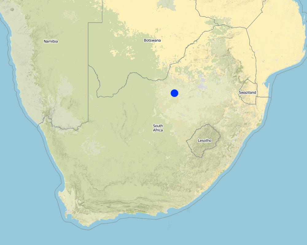
ປະເທດ:
ອາຟິກກາໃຕ້
ພາກພື້ນ / ລັດ / ແຂວງ:
North West Province
ຂໍ້ມູນເພີ່ມເຕີມຂອງສະຖານທີ່:
Lichtenburg
Map
×2.6 ວັນທີໃນການຈັດຕັ້ງປະຕິບັດ
ຖ້າຫາກວ່າ ບໍ່ຮູ້ຈັກ ປີທີ່ຊັດເຈນ ແມ່ນໃຫ້ປະມານ ວັນທີເອົາ:
- 10-50 ປີ ຜ່ານມາ
2.7 ການນໍາສະເໜີ ເຕັກໂນໂລຢີ
ໃຫ້ລະບຸ ເຕັກໂນໂລຢີ ໄດ້ຖືກຈັດຕັ້ງປະຕິບັດຄືແນວໃດ?
- ໂດຍຜ່ານໂຄງການ / ການຊ່ວຍເຫຼືອຈາກພາຍນອກ
ຄວາມຄິດເຫັນ (ປະເພດ ໂຄງການ ແລະ ອື່ນໆ):
The contour part came mainly form the USA.
The watercourse part was developed in South Africa.
3. ການໃຈ້ແຍກ ເຕັກໂນໂລຢີ ໃນການຄຸ້ມຄອງ ດິນແບບຍືນຍົງ
3.2 ປະເພດການນໍາໃຊ້ທີ່ດິນ ໃນປະຈຸບັນ() ທີ່ເຕັກໂນໂລຢີ ໄດ້ຖືກນໍາໃຊ້

ດິນທີ່ປູກພືດ
- ການປູກພືດປະຈໍາປີ
ຄວາມຄິດເຫັນ:
Major land use problems (compiler’s opinion): Cultivating lands without the necessary soil conservation works to prevent soil erosion.
Major land use problems (land users’ perception): Cultivating the lands preventing soil erosion through plant directions
3.3 ຂໍ້ມູນເພີ່ມເຕີມກ່ຽວກັບການນໍາໃຊ້ທີ່ດິນ
ການສະໜອງນໍ້າ ໃນພື້ນທີ່ ທີ່ໄດ້ນໍາໃຊ້ ເຕັກໂນໂລຢີ:
- ນໍ້າຝົນ
ຈໍານວນ ລະດູການ ປູກໃນປີໜຶ່ງ:
- 1
ລະບຸ ຊະນິດ:
Longest growing period in days: 180
Longest growing period from month to month: Oct - Mar
3.5 ການຂະຫຍາຍເຕັກໂນໂລຢີ
ໃຫ້ລະບຸ ການແຜ່ຂະຫຍາຍ ເຕັກໂນໂລຢີ:
- ແຜ່ຂະຫຍາຍຢ່າງໄວວາໃນພື້ນທີ່
ຖ້າຫາກວ່າ ເຕັກໂນໂລຢີ ໄດ້ແຜ່ຂະຫຍາຍທົ່ວພື້ນທີ່ືື ຢ່າງສະໜ່ຳສະເໝີ, ໃຫ້ລະບຸ ເນື້ອທີ່ ໂດຍການຄາດຄະເນ:
- 1-10 ກມ 2
ຄວາມຄິດເຫັນ:
Total area covered by the SLM Technology is 3 m2.
Although the total extent of the farm is 584 ha, only 250 ha plus 50 ha adjacent land was addressed through this technology.
3.6 ມາດຕະການ ການຄຸ້ມຄອງ ທີ່ດິນແບບຍືນຍົງ ປະກອບດ້ວຍ ເຕັກໂນໂລຢີ
3.7 ປະເພດດິນເຊື່ອມໂຊມ ຫຼັກທີ່ໄດ້ນໍາໃຊ້ ເຕັກໂນໂລຢີ

ດິນເຊາະເຈື່ອນ ໂດຍນໍ້າ
- Wg: ການເຊາະເຈື່ອນຮ່ອງນ້ຳ / ຫ້ວຍ
- Wt: ການສູນເສຍຊັ້ນໜ້າດິນ / ການເຊາະເຈື່ອນຜິວໜ້າດິນ

ການເຊື່ອມໂຊມ ຂອງນໍ້າ
- Ha: ສະພາບແຫ້ງແລ້ງ

ການເຊື່ອມໂຊມ ຂອງດິນ ທາງເຄມີ
- Cn: ຄວາມອຸດົມສົມບູນ ລົດໜ້ອຍຖອຍລົງ ແລະ ສານອິນຊີວັດຖຸລົດລົງ (ບໍ່ແມ່ນສາເຫດມາຈາກການເຊາະເຈື່ອນ)
ຄວາມຄິດເຫັນ:
Main type of degradation addressed: Wt: loss of topsoil / surface erosion, Wg: gully erosion / gullying, Ha: aridification
Secondary types of degradation addressed: Cn: fertility decline and reduced organic matter content
Main causes of degradation: other human induced causes (specify) (Agricultural causes - Cultivating land on a step slope without proper conservation practices.), education, access to knowledge and support services (Lack of knowledge - How to solve the problem)
Secondary causes of degradation: other natural causes (avalanches, volcanic eruptions, mud flows, highly susceptible natural resources, extreme topography, etc.) specify (Topography; concentrating water in valleys causing soil erosion (steep slopes).), Poor conservation ethic
3.8 ການປ້ອງກັນ, ການຫຼຸດຜ່ອນ, ຫຼືການຟື້ນຟູຂອງການເຊື່ອມໂຊມຂອງດິນ
ໃຫ້ລະບຸ ເປົ້າໝາຍ ເຕັກໂນໂລຢີ ທີ່ພົວພັນ ກັບຄວາມເຊື່ອມໂຊມຂອງດິນ:
- ຫຼຸດຜ່ອນການເຊື່ອມໂຊມຂອງດິນ
- ປ້ອງກັນການເຊື່ອມໂຊມຂອງດິນ
ຄວາມຄິດເຫັນ:
Main goals: prevention of land degradation, mitigation / reduction of land degradation
4. ຂໍ້ກໍາໜົດ, ກິດຈະກໍາການປະຕິບັດ, ວັດຖຸດິບ, ແລະຄ່າໃຊ້ຈ່າຍ
4.1 ເຕັກນິກ ໃນການແຕ້ມແຜນວາດ ເຕັກໂນໂລຢີ
ຜູ້ຂຽນ:
Pieter J. Theron
4.2 ການແຕ້ມແຜນວາດອະທິບາຍເຕັກນິກ
Water run-off control plan
Location: Lichtenburg. North West
Technical knowledge required for field staff / advisors: high
Technical knowledge required for land users: low
Main technical functions: control of dispersed runoff: impede / retard, control of concentrated runoff: drain / divert, reduction of slope length
Secondary technical functions: control of dispersed runoff: retain / trap, increase of infiltration, increase / maintain water stored in soil, Maintain soil fertility as less fertilizer are lost by water run-off
Vegetative measure: watercourses
Vegetative material: C : perennial crops, G : grass
Number of plants per (ha): seeds 6-8kg/ha
Vegetative measure: Vegetative material: C : perennial crops, G : grass
Vegetative measure: Vegetative material: C : perennial crops, G : grass
Vegetative measure: Vegetative material: C : perennial crops, G : grass
Grass species: Digitaria Smuts, Eragrostis curvula, Cynodom dactylon
Structural measure: bunds/banks: contour
Vertical interval between structures (m): 1.3-1.75
Spacing between structures (m): 72-33
Depth of ditches/pits/dams (m): 0.4
Width of ditches/pits/dams (m): 2
Height of bunds/banks/others (m): 0.3
Width of bunds/banks/others (m): 4
Construction material (earth): Construction contour banks with soil form the ditches
Lateral gradient along the structure: 0.3%
Vegetation is used for stabilisation of structures.
4.3 ຂໍ້ມູນທົ່ວໄປກ່ຽວກັບການຄິດໄລ່ປັດໃຈຂາເຂົ້າໃນການຜະລິດ ແລະ ມູນຄ່າອື່ນໆ
ສະກຸນເງິນອື່ນໆ / ປະເທດອື່ນໆ (ລະບຸ):
rand
ລະບຸ ອັດຕາແລກປ່ຽນ ຈາກໂດລາ ເປັນເງິນຕາທ້ອງຖີ່ນ (ຖ້າກ່ຽວຂ້ອງ): 1 ໂດລາ =:
6.00
4.4 ການສ້າງຕັ້ງກິດຈະກໍາ
| ກິດຈະກໍາ | ປະເພດ ມາດຕະການ | ໄລຍະເວລາ | |
|---|---|---|---|
| 1. | Established grass in the watercourses | ການບໍາລຸງລ້ຽງ | After construction according to design specifications |
| 2. | Surveying | ໂຄງສ້າງ | Dry season |
| 3. | Construction of contours | ໂຄງສ້າງ | Any time depending on soil moisture |
| 4. | Construction of watercourse | ໂຄງສ້າງ | Before growing season |
4.5 ຕົ້ນທຶນ ແລະ ປັດໄຈຂາເຂົ້າທີ່ຈໍາເປັນໃນຈັດຕັ້ງປະຕິບັດ
ຄວາມຄິດເຫັນ:
Duration of establishment phase: 24 month(s)
4.6 ບໍາລຸງຮັກສາ / ແຜນຈັດຕັ້ງປະຕິບັດ ກິດຈະກໍາ
| ກິດຈະກໍາ | ປະເພດ ມາດຕະການ | ໄລຍະເວລາ / ຄວາມຖີ່ | |
|---|---|---|---|
| 1. | Building contours and watercourses | ພືດ | Any time / Before planting of crops |
| 2. | Building contours and watercourses | ພືດ | Depending on soil moisture / |
| 3. | Maintenance | ພືດ | Before planting of crops / Annually |
| 4. | Cultivation between contours | ພືດ | Depending on the crop / Annually |
| 5. | Maintaining a good grass cover | ການບໍາລຸງລ້ຽງ | Rainy season /Once or more times a year depending on the grass |
| 6. | Fertilisation of the grass in the watercourse | ການບໍາລຸງລ້ຽງ | Rainy season /Once or twice in the rainy season |
| 7. | Watercourse, cutting the grass | ໂຄງສ້າງ | Beginning of rainy season/Annual |
| 8. | Contours repairing flood damage | ໂຄງສ້າງ | Dry season/After heavy rains |
| 9. | Contour opening ditches | ໂຄງສ້າງ | Before planting of cops/Annual |
4.7 ຄ່າໃຊ້ຈ່າຍ ແລະ ປັດໄຈນໍາເຂົ້າທີ່ຈໍາເປັນສໍາລັບການບໍາລຸງຮັກສາກິດຈະກໍາ / ແຜນປະຕິບັດ (ຕໍ່ປີ)
ຄວາມຄິດເຫັນ:
Machinery/ tools: Tractor & plough or a grader
Contours per kilometre. NB currant tariff for subsidy. Watercourse construction per volume soil moved and grass establishing per ha above the current tariff for subsidy from April 1998
4.8 ປັດໄຈ ທີ່ສໍາຄັນ ທີ່ສົ່ງຜົນກະທົບ ຕໍ່ຄ່າໃຊ້ຈ່າຍ
ໃຫ້ອະທິບາຍ ປັດໃຈ ທີ່ສົ່ງຜົນກະທົບ ຕໍ່ຕົ້ນທຶນ ໃນການຈັດຕັ້ງປະຕິບັດ:
Soil moisture and clay contents
5. ສະພາບແວດລ້ອມທໍາມະຊາດ ແລະ ມະນຸດ
5.1 ອາກາດ
ປະລິມານນໍ້າຝົນປະຈໍາປີ
- < 250 ມີລິແມັດ
- 251-500 ມີລິແມັດ
- 501-750 ມີລິແມັດ
- 751-1,000 ມີລິແມັດ
- 1,001-1,500 ມີລິແມັດ
- 1,501-2,000 ມີລິແມັດ
- 2,001-3,000 ມີລິແມັດ
- 3,001-4,000 ມີລິແມັດ
- > 4,000 ມີລິແມັດ
ເຂດສະພາບອາກາດກະສິກໍາ
- ເຄິ່ງແຫ້ງແລ້ງ
5.2 ພູມິປະເທດ
ຄ່າສະເລ່ຍ ຄວາມຄ້ອຍຊັນ:
- ພື້ນທີ່ຮາບພຽງ (0-2%)
- ອ່ອນ (3-5 %)
- ປານກາງ (6-10 %)
- ມ້ວນ (11-15 %)
- ເນີນ(16-30%)
- ໍຊັນ (31-60%)
- ຊັນຫຼາຍ (>60%)
ຮູບແບບຂອງດິນ:
- ພູພຽງ / ທົ່ງພຽງ
- ສັນພູ
- ເປີ້ນພູ
- ເນີນພູ
- ຕີນພູ
- ຮ່ອມພູ
ເຂດລະດັບສູງ:
- 0-100 ແມັດ a.s.l.
- 101-500 ແມັດ a.s.l.
- 501-1,000 ແມັດ a.s.l.
- 1,001-1,500 ແມັດ a.s.l.
- 1,501-2,000 ແມັດ a.s.l.
- 2,001-2,500 ແມັດ a.s.l.
- 2,501-3,000 ແມັດ a.s.l.
- 3,001-4,000 ແມັດ a.s.l.
- > 4,000 ແມັດ a.s.l.
5.3 ດິນ
ຄວາມເລິກ ຂອງດິນສະເລ່ຍ:
- ຕື້ນຫຼາຍ (0-20 ຊັງຕີແມັດ)
- ຕື້ນ (21-50 ຊຕມ)
- ເລີກປານກາງ (51-80 ຊຕມ)
- ເລິກ (81-120 ຊມ)
- ເລິກຫຼາຍ (> 120 cm)
ເນື້ອດິນ (ໜ້າດິນ):
- ປານກາງ (ດິນໜຽວ, ດິນໂຄນ)
ຊັ້ນອິນຊີວັດຖຸ ເທິງໜ້າດິນ:
- ຕໍາ່ (<1 %)
5.6 ຄຸນລັກສະນະ ຂອງຜູ້ນໍາໃຊ້ທີ່ດິນ ທີ່ໄດ້ນໍາໃຊ້ເຕັກໂນໂລຢີ
ລະບົບ ການຕະຫຼາດ ແລະ ຜົນຜະລິດ:
- ການຄ້າ / ຕະຫຼາດ
ລາຍຮັບ ທີ່ບໍ່ໄດ້ມາຈາກ ການຜະລິດ ກະສິກໍາ:
- ໜ້ອຍກ່ວາ 10 % ຂອງລາຍຮັບທັງໝົດ
ລະດັບຄວາມຮັ່ງມີ:
- ສະເລ່ຍ
ລະດັບ ການຫັນເປັນກົນຈັກ:
- ເຄື່ອງກົນຈັກ
ໃຫ້ລະບຸ ຄຸນລັກສະນະ ຂອງຜູ້ນໍາໃຊ້ທີ່ດິນ:
Population density: 10-50 persons/km2
Annual population growth: 1% - 2%
10% of the land users are very rich and own 100% of the land.
90% of the land users are average wealthy and own 100% of the land (If management is good).
Off-farm income specification: Farmers are dedicated to make a living out of farming, although there are some farmers with an off-farm income such as transport.
5.7 ພື້ນທີ່ສະເລ່ຍຂອງທີ່ດິນ ຫຼື ເຊົ່າໂດຍຜູ້ໃຊ້ທີ່ດິນການນໍາໃຊ້ ເຕັກໂນໂລຢີ
- <0.5 ເຮັກຕາ
- 0.5-1 ເຮັກຕາ
- 1-2 ເຮັກຕາ
- 2-5 ເຮັກຕາ
- 5-15 ເຮັກຕາ
- 15-50 ເຮັກຕາ
- 50-100 ເຮັກຕາ
- 100-500 ເຮັກຕາ
- 500-1,000 ເຮັກຕາ
- 1,000-10,000 ເຮັກຕາ
- > 10,000 ເຮັກຕາ
5.8 ເຈົ້າຂອງທີ່ດິນ, ສິດໃຊ້ທີ່ດິນ, ແລະ ສິດທິການນໍາໃຊ້ນໍ້າ
ເຈົ້າຂອງດິນ:
- ບຸກຄົນ, ທີ່ມີຕໍາແໜ່ງ
ສິດທິ ໃນການນໍາໃຊ້ທີ່ດິນ:
- ບຸກຄົນ
6. ຜົນກະທົບ ແລະ ລາຍງານສະຫຼຸບ
6.1 ການສະແດງຜົນກະທົບ ພາຍໃນພື້ນທີ່ ທີ່ໄດ້ຈັດຕັ້ງປະຕິບັດ ເຕັກໂນໂລຢີ
ຜົນກະທົບທາງເສດຖະກິດສັງຄົມ
ການຜະລິດ
ການຜະລິດພືດ
ເນື້ອທີ່ການຜະລິດ
ການຈັດການຄຸ້ມຄອງທີ່ດິນ
ຜົນກະທົບດ້ານວັດທະນາທໍາສັງຄົມ
ການຫຼຸດຜ່ອນ ຂໍ້ຂັດແຍ່ງ
ຜົນກະທົບຕໍ່ລະບົບນິເວດ
ວົງຈອນນໍ້າ / ນໍ້າ
ການໄຫຼ ຂອງນໍ້າໜ້າດິນ
ປະລິມານ ກ່ອນການຈັດຕັ້ງປະຕິບັດ ການຄຸ້ມຄອງ ທີ່ດິນແບບຍືນຍົງ:
60
ປະລີມານ ຫຼັງການຈັດຕັ້ງປະຕິບັດ ການຄຸ້ມຄອງ ທີ່ດິນແບບຍືນຍົງ:
20
ການລະບາຍນໍ້າ
ດິນ
ຄວາມຊຸ່ມຂອງດິນ
ການສູນເສຍດິນ
ປະລິມານ ກ່ອນການຈັດຕັ້ງປະຕິບັດ ການຄຸ້ມຄອງ ທີ່ດິນແບບຍືນຍົງ:
25
ປະລີມານ ຫຼັງການຈັດຕັ້ງປະຕິບັດ ການຄຸ້ມຄອງ ທີ່ດິນແບບຍືນຍົງ:
4
6.2 ຜົນກະທົບທາງອ້ອມ ຈາກການນໍາໃຊ້ເຕັກໂນໂລຢີ
ການທັບຖົມ ຂອງດິນຕະກອນ ຢູ່ເຂດລຸ່ມນໍ້າ
ມົນລະພິດ ທາງນໍ້າ / ນໍ້າໄຕ້ດິນ
6.4 ການວິເຄາະຕົ້ນທຶນ ແລະ ຜົນປະໂຫຍດ
ຈະເຮັດປະໂຫຍດເພື່ອປຽບທຽບກັບຄ່າໃຊ້ຈ່າຍກັບສິ່ງກໍ່ສ້າງ (ຈາກທັດສະນະຂອງຜູ້ນຳໃຊ້ທີ່ດິນ) ໄດ້ແນວໃດ?
ຜົນຕອບແທນ ໃນໄລຍະສັ້ນ:
ປານກາງ
ຜົນຕອບແທນ ໃນໄລຍະຍາວ:
ປານກາງ
ຈະໄດ້ຮັບຜົນປະໂຫຍດເມື່ອປຽບທຽບກັບ / ຄ່າໃຊ້ຈ່າຍໃນການບຳລຸງຮັກສາທີເ່ກີດຂື້ນອິກ (ຈາກທັດສະນະຄະຕິຂອງຜູ້ນຳໃຊ້ທີ່ດິນ) ໄດ້ແນວໃດ?
ຜົນຕອບແທນ ໃນໄລຍະສັ້ນ:
ປານກາງ
ຜົນຕອບແທນ ໃນໄລຍະຍາວ:
ປານກາງ
6.5 ການປັບຕົວຮັບເອົາເຕັກໂນໂລຢີ
ຄວາມຄິດເຫັນ:
15% of land user families have adopted the Technology with external material support
Comments on acceptance with external material support: estimates
1% of land user families have adopted the Technology without any external material support
Comments on spontaneous adoption: estimates
There is a little trend towards spontaneous adoption of the Technology
Comments on adoption trend: So little, almost none. The lack in technicians from government promoting this technology and to deliver technical services are the main reasons expect for the poor conservation ethic of the farmers.
6.7 ຈຸດແຂງ / ຂໍ້ດີ / ໂອກາດ ໃນການນໍາໃຊ້ ເຕັກໂນໂລຢີ
| ຈຸດແຂງ / ຂໍ້ດີ / ໂອກາດໃນການນໍາໃຊ້ທີ່ດິນ |
|---|
|
Prevent soil erosion How can they be sustained / enhanced? Good regular maintenance |
| Building up a good layer of topsoil |
| Effective run-off control of excess rainwater |
| ຈຸດແຂງ / ຈຸດດີ / ໂອກາດ ຈາກທັດສະນະຂອງຜູ້ປ້ອນຂໍ້ມູນ ຫຼື ບຸກຄົນສຳຄັນ |
|---|
|
Effective erosion control How can they be sustained / enhanced? Regular maintenance |
|
Improve water infiltration How can they be sustained / enhanced? Good cultivation practices and maintenance of contours |
|
Increase crop yield How can they be sustained / enhanced? Good cultivation practices and maintenance of contours |
|
Prevent off-site siltation How can they be sustained / enhanced? Good maintenance |
6.8 ຈຸດອ່ອນ / ຂໍ້ເສຍ / ຄວາມສ່ຽງ ໃນການນໍາໃຊ້ ເຕັກໂນໂລຢີ ແລະ ວິທີການແກ້ໄຂບັນຫາ
| ຈຸດອ່ອນ / ຂໍ້ເສຍ / ຄວາມສ່ຽງໃນມຸມມອງຂອງຜູ້ນໍາໃຊ້ທີ່ດິນ | ມີວິທີການແກ້ໄຂຄືແນວໃດ? |
|---|---|
| Hampers cultivation | Adapt change in cultivation practises |
| ຈຸດອ່ອນ/ຂໍ້ບົກຜ່ອງ/ຄວາມສ່ຽງ ຈາກທັດສະນະຂອງຜູ້ປ້ອນຂໍ້ມູນ ຫຼື ບຸກຄົນສຳຄັນ | ມີວິທີການແກ້ໄຂຄືແນວໃດ? |
|---|---|
| Cannot think of any |
ຂໍ້ມູນການເຊື່ອມຕໍ່ ແລະ ເນື້ອໃນ
ຂະຫຍາຍທັງໝົດ ຍຸບທັງໝົດການເຊື່ອມຕໍ່
ບໍ່ມີຂໍ້ມູນການເຊື່ອມຕໍ່
ເນື້ອໃນ
ບໍ່ມີເນື້ອໃນ