
Integrated Land and Water Management [ໂມລໂດວາ]
- ການສ້າງ:
- ປັບປູງ:
- ຜູ້ສັງລວມຂໍ້ມູນ: Valentin Ciubotaru
- ບັນນາທິການ: Valentin Ciubotaru, UNCCD PRAIS
- ຜູ້ທົບທວນຄືນ: Farrukh Nazarmavloev, William Critchley, Rima Mekdaschi Studer
Managementul integrat al solului și al apei
technologies_1817 - ໂມລໂດວາ
ເບິ່ງພາກສ່ວນ
ຂະຫຍາຍທັງໝົດ ຍຸບທັງໝົດ1. ຂໍ້ມູນທົ່ວໄປ
1.2 ຂໍ້ມູນ ການຕິດຕໍ່ພົວພັນ ຂອງບຸກຄົນທີ່ສໍາຄັນ ແລະ ສະຖາບັນ ທີ່ມີສ່ວນຮ່ວມ ໃນການປະເມີນເອກກະສານ ເຕັກໂນໂລຢີ
ບັນດາຜູ້ຕອບແບບສອບຖາມທີ່ສໍາຄັນ ()
ຜຸ້ຊ່ຽວຊານ ດ້ານການຄຸ້ມຄອງ ທີ່ດິນແບບຍືນຍົງ:
Ciubotaru Valentin
+37322723372 / +37369134294
valentin.ciubotaru@yahoo.com / valentin.chiubotaru@gmail.com
NGO BIOS
11/1 Gheorghe Asachi str., ap. nr. 87
ໂມລໂດວາ
ຊື່ສະຖາບັນ (ຫຼາຍສະຖາບັນ) ທີ່ອໍານວຍຄວາມສະດວກ ໃນການສ້າງເອກກະສານ / ປະເມີນ ເຕັກໂນໂລຢີ (ຖ້າກ່ຽວຂ້ອງ)
NGO BIOS (.) - ໂມລໂດວາ1.3 ເງື່ອນໄຂ ກ່ຽວກັບ ການນໍາໃຊ້ຂໍ້ມູນເອກະສານ ທີ່ສ້າງຂື້ນ ໂດຍຜ່ານ ອົງການພາບລວມຂອງໂລກ ທາງດ້ານແນວທາງ ແລະ ເຕັກໂນໂລຢີ ຂອງການອານຸລັກ ທໍາມະຊາດ (WOCAT)
ເມື່ອໃດທີ່ໄດ້ສັງລວມຂໍ້ມູນ (ຢູ່ພາກສະໜາມ)?
01/07/2010
ຜູ້ປ້ອນຂໍ້ມູນ ແລະ ບຸກຄົນສຳຄັນ ທີ່ໃຫ້ຂໍ້ມູນ (ຫຼາຍ) ຍິນຍອມ ຕາມເງື່ອນໄຂ ໃນການນຳໃຊ້ຂໍ້ມູນ ເພື່ອສ້າງເປັນເອກກະສານຂອງ WOCAT:
ແມ່ນ
1.4 ແຈ້ງການວ່າ ດ້ວຍຄວາມຍືນຍົງຂອງ ເຕັກໂນໂລຢີ
ການນໍາໃຊ້ ເຕັກໂນໂລຢີ ດັ່ງກ່າວໄດ້ອະທິບາຍ ເຖິງບັນຫາ ກ່ຽວກັບ ການເຊື່ອມໂຊມຂອງດິນບໍ? ຖ້າບໍ່ດັ່ງນັ້ນ ມັນບໍ່ສາມາດ ຢັ້ງຢືນໄດ້ວ່າ ເປັນເຕັກໂນໂລຊີ ໃນການຄຸ້ມຄອງ ທີ່ດິນແບບຍືນຍົງ? :
ບໍ່ແມ່ນ
2. ການອະທິບາຍ ເຕັກໂນໂລຢີ ຂອງການຄຸ້ມຄອງ ທີ່ດິນແບບຍືນຍົງ
2.1 ຄໍາອະທິບາຍສັ້ນຂອງ ເຕັກໂນໂລຢີ
ການກຳໜົດຄວາມໝາຍ ຂອງເຕັກໂນໂລຢີ:
Integrated land and water management was promoted in order to improve agricultural production while reducing soil loss and nutrient discharge into water bodies. Technical assistance and financial support was provided for sustainable agricultural practices, including: nutrient management, conservation agriculture, integrated cropping management, agroforestry and wetland management.
2.2 ການອະທິບາຍ ລາຍລະອຽດ ຂອງເຕັກໂນໂລຢີ
ການພັນລະນາ:
Integrated land and water management was promoted in order to improve agricultural production while reducing soil loss and nutrient discharge into water bodies. Technical assistance and financial support was provided for sustainable agricultural practices, including:
1. Manure Management Practices:
Organic manure was substituted for inorganic fertilizer, and eight commune/village stores were constructed together with 1200 household stores and equipment provided for manure handling and field application. A monitoring database was made available.
2. Promotion of Environment-Friendly Agricultural Practices:
A well-documented pilot was completed and evaluated for replication, and 300 farmers then trained in the application of environment-friendly agricultural practices. The capacity of extension staff significantly improved. A monitoring system to determine the impact of practices on soil quality was installed and data collected.
3. Shrub and Tree Planting:
• 132 hectares of shelterbelts for water protection established; 112 hectares of improved anti-erosion forest belts set up; 50 hectares of improved pasture established; 484 hectares of the existing forests rehabilitated and properly managed; forest monitoring was incorporated into the general monitoring scheme.
4.Wetland Restoration and Promotion of Sustainable Management Practices:
The existing ecosystems were rehabilitated and ecologically well balanced. In this context two dams were built with a sluice gate system for the stabilization of water levels; three concrete bridges with adequate culvert capacity were installed for accessibility to different portions of the wetland; and 10 small wood bridges with culverts were built for access.
5 .Monitoring Soil and Water Quality and Environmental Impacts
Availability of water for downstream users and fisheries was increased, drinking water supplies was improved, there was increased quality and availability of groundwater for human and animal consumption, and simultaneously better productive lands with increased organic matter and carbon sequestration, as well as increased biodiversity.
Key Elements of the Manure Management System:
a. Segregation of inert and recyclable materials from livestock waste through the provision of a separate household waste container.
b. Improved manure stores for storage of waste at a single impermeable store at the household with enough storage for up to one month's production.
c. Transfer of waste from the farm store to a central site, using transport units then unloading it at the commune platform, to aerate the waste, promoting continued bacterial activity.
d. At the commune/village store level, the segregated inert materials deposited in designated bunkers.
e. At the commune/village store level, management of the household manure at the main bunker involving stacking in shaped windrow heaps three metres high.
f. Store the waste deep so that the areas getting wet from rainfall is minimised. Provide impermeable walls and floor to eliminate leaching.
g. Provide storage capacity for over the winter so that matured manure will be available for use on the land.
Key Elements of facilities at the Village Platform are:
a. Concrete area for the management of the manure.
b. Bunkers for the segregated household manure.
c. Collecting channel for runoff from the platform.
d. Storage pits and tanks with impermeable base and walls.
e. Security fencing.
f. Office / Staff facilities and Landscaping. Monitoring wells to check for leakages.
Overall results show that 8,250 farmers from both the project pilot area and other regions of Moldova had adopted at least one environmentally-friendly agricultural practice promoted by the project, and had implemented these on 14,028 ha of land.
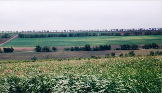
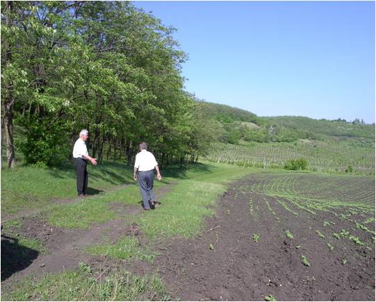
2.3 ຮູບພາບຂອງເຕັກໂນໂລຢີ
ສື່ຮູບພາບ
2.5 ປະເທດ / ເຂດ / ສະຖານທີ່ບ່ອນທີ່ ເຕັກໂນໂລຢີ ໄດ້ຮັບການນໍາໃຊ້ ແລະ ທີ່ຖືກປົກຄຸມດ້ວຍການປະເມີນຜົນ
ປະເທດ:
ໂມລໂດວາ
ພາກພື້ນ / ລັດ / ແຂວງ:
Hincesti and Orhei districts
ຂໍ້ມູນເພີ່ມເຕີມຂອງສະຖານທີ່:
Negrea, Lapusna, Carpineni, Minjir communes, Hincesti district; Sarata Razesti commune, Leova district, and Jora de Mijloc, Orhei district
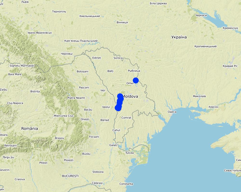
Map
×3. ການໃຈ້ແຍກ ເຕັກໂນໂລຢີ ໃນການຄຸ້ມຄອງ ດິນແບບຍືນຍົງ
3.1 ຈຸດປະສົງຫຼັກ (ຫຼາຍ) ຂອງເຕັກໂນໂລຢີ
- ປັບປຸງ ການຜະລິດ
- ຫຼຸດຜ່ອນ, ປ້ອງກັນ, ຟື້ນຟູ ການເຊື່ອມໂຊມຂອງດິນ
- ການອະນຸລັກ ລະບົບນິເວດ
- ປົກປັກຮັກສານໍ້າ / ນໍ້າພື້ນທີ່ - ປະສົມປະສານກັບ ເຕັກໂນໂລຢີອື່ນໆ
- ປົກປັກຮັກສາ / ການປັບປຸງຊີວະນາໆພັນ
- ຫຼຸດຜ່ອນຄວາມສ່ຽງ ທາງໄພພິບັດທໍາມະຊາດ
- ສ້າງຜົນກະທົບ ທາງເສດຖະກິດ ທີ່ເປັນປະໂຫຍດ
3.2 ປະເພດການນໍາໃຊ້ທີ່ດິນ ໃນປະຈຸບັນ() ທີ່ເຕັກໂນໂລຢີ ໄດ້ຖືກນໍາໃຊ້

ດິນທີ່ປູກພືດ
- ການປູກພືດປະຈໍາປີ
- ພືດຢືນຕົ້ນ (ບໍ່ແມ່ນໄມ້)
- ເປັນໄມ້ຢືນຕົ້ນ ແລະ ໄມ້ພຸ່ມ ຈາກການປູກພືດ
ການປູກພືດຫຼັກ (ທີ່ສາມາດສ້າງລັບຮັບ ເປັນເງິນສົດ ແລະ ເປັນພືດສະບຽງອາຫານ):
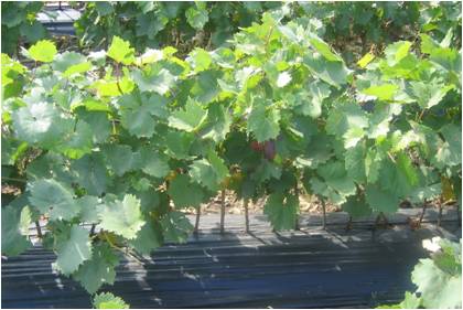
Wheat, corn, sunflower, alfalfa (lucerne), vineyards, orchards, vegetables

ທິດທາງໄຫຼຂອງນໍ້າ, ນໍ້າ, ດິນທາມ
- ທໍ່ລະບາຍນໍ້າ, ທິດທາງນໍ້າ
- ໜອງ, ດິນທາມ
ຜະລິດຕະພັນຫຼັກ / ບໍລິການ:
The existing ecosystems rehabilitated and ecologically well balanced; dams with a sluice gate system for the stabilization of water levels; concrete bridges with adequate culvert capacity for access to different portions of the wetland; and wooden bridges with culvert capacity for access through the zone constructed
3.3 ຂໍ້ມູນເພີ່ມເຕີມກ່ຽວກັບການນໍາໃຊ້ທີ່ດິນ
ການສະໜອງນໍ້າ ໃນພື້ນທີ່ ທີ່ໄດ້ນໍາໃຊ້ ເຕັກໂນໂລຢີ:
- ປະສົມປະສານ ກັນລະຫວ່າງ ນໍ້າຝົນ ແລະ ນໍ້າຊົນລະປະທານ
ຈໍານວນ ລະດູການ ປູກໃນປີໜຶ່ງ:
- 1
ລະບຸ ຊະນິດ:
1 growing season per year for rainfed and 2 growing seasons per year for irrigated areas
3.4 ການນໍາໃຊ້ເຕັກໂນໂລຢີ ທີ່ຢູ່ໃນກຸ່ມການຄຸ້ມຄອງ ທີ່ດິນແບບຍືນຍົງ
- ການຄຸ້ມຄອງການປູກປ່າ
- ລະບົບການປູກພືດໝູນວຽນ (ການປູກພືດໝູນວຽນ, ປ່າເລົ່າ, ການຖາງປ່າເຮັດໄຮ່)
- ການຄຸ້ມຄອງພືດ ແລະ ລ້ຽງສັດ ແບບປະສົມປະສານ
3.5 ການຂະຫຍາຍເຕັກໂນໂລຢີ
ໃຫ້ລະບຸ ການແຜ່ຂະຫຍາຍ ເຕັກໂນໂລຢີ:
- ແຜ່ຂະຫຍາຍຢ່າງໄວວາໃນພື້ນທີ່
ຖ້າຫາກວ່າ ເຕັກໂນໂລຢີ ໄດ້ແຜ່ຂະຫຍາຍທົ່ວພື້ນທີ່ືື ຢ່າງສະໜ່ຳສະເໝີ, ໃຫ້ລະບຸ ເນື້ອທີ່ ໂດຍການຄາດຄະເນ:
- > 10,000 ກມ 2
ຄວາມຄິດເຫັນ:
8,250 farmers from both project pilot area and other regions of Moldova that adopted at least one environmentally friendly agricultural practice promoted by the project implemented on as much as 14,028 ha of land in total.
3.6 ມາດຕະການ ການຄຸ້ມຄອງ ທີ່ດິນແບບຍືນຍົງ ປະກອບດ້ວຍ ເຕັກໂນໂລຢີ

ມາດຕະການ ທາງການກະສິກໍາ
- A1: ພືດ / ການປົກຫຸ້ມຂອງດິນ
- A2: ອິນຊີວັດຖຸ ຫຼື ຄວາມອຸດົມສົມບູນໃນດິນ

ມາດຕະການ ທາງດ້ານພືດພັນ
- V1: ເປັນໄມ້ຢືນຕົ້ນ ແລະ ການປົກຫຸ້ມຂອງໄມ້ພຸ່ມ
- V2: ຫຍ້າ ແລະ ພືດສະໝູນໄພທີ່ເປັນໄມ້ຢືນຕົ້ນ
- V4: ການປູກທົດແທນ / ກຳຈັດສາຍພັນ ທີ່ຮຸກຮາມ

ມາດຕະການ ທາງດ້ານການຄຸ້ມຄອງ
- M2: ການປ່ຽນແປງ ການຈັດການຄຸ້ມຄອງ / ລະດັບຄວາມໜາແໜ້ນ
- M3: ອີງຕາມສະພາບແວດລ້ອມ ທາງທຳມະຊາດ ແລະ ມະນຸດ
- M5: ການຄວບຄຸມ / ການປ່ຽນແປງຂອງອົງປະກອບຂອງຊະນິດ
- M6: ການຈັດການສິ່ງເສດເຫຼືອ (ຂີ້ເຫຍື້ອ, ນໍາໃຊ້ຄືນໃຫມ່ ຫຼື ຫຼຸດຜ່ອນ)
3.7 ປະເພດດິນເຊື່ອມໂຊມ ຫຼັກທີ່ໄດ້ນໍາໃຊ້ ເຕັກໂນໂລຢີ

ດິນເຊາະເຈື່ອນ ໂດຍນໍ້າ
- Wt: ການສູນເສຍຊັ້ນໜ້າດິນ / ການເຊາະເຈື່ອນຜິວໜ້າດິນ
- Wg: ການເຊາະເຈື່ອນຮ່ອງນ້ຳ / ຫ້ວຍ
- Wm: ການເຄື່ອນຍ້າຍອິນຊີວັດຖຸ / ດິນເຈື່ອນ
- Wr: ແຄມຕາຝັ່ງເຈື່ອນ
- Wo: ຜົນກະທົບ ຂອງການເຊື່ອມໂຊມ ຕໍ່ພື້ນທີ່ພາຍນອກ

ການເຊື່ອມໂຊມ ຂອງດິນ ທາງເຄມີ
- Cn: ຄວາມອຸດົມສົມບູນ ລົດໜ້ອຍຖອຍລົງ ແລະ ສານອິນຊີວັດຖຸລົດລົງ (ບໍ່ແມ່ນສາເຫດມາຈາກການເຊາະເຈື່ອນ)
- Cp: ດິນເປັນມົນລະພິດ
- Cs: ການເຮັດໃຫ້ເກີດດິນເຄັມ / ເປັນດ່າງ

ການເຊື່ອມໂຊມ ຂອງດິນ ທາງກາຍະພາບ
- Pc: ການອັດແໜ້ນ
- Pk: ການບັນເທົາ ແລະ ການປົກຄຸມຂອງເປືອກໂລກ
- Ps: ຊຸດຂອງດິນອົງຄະທາດ, ການຕັ້ງຖິ່ນຖານຂອງດິນ

ການເຊື່ອມໂຊມ ທາງຊີວະພາບ
- Bc: ການຫຼຸດຜ່ອນການປົກຫຸ້ມຂອງພືດ
- Bh: ການສູນເສຍ ທີ່ຢູ່ອາໃສ ຂອງສິ່ງທີ່ມີຊິວິດ
- Bq: ປະລິມານ / ອິນຊີວັດຖຸຫຼຸດລົງ
- Bs: ຄຸນນະພາບ / ການອັດແໜ້ນ ຂອງສາຍພັນຫຼຸດລົງ
- Bl: ການສູນເສຍ ຈຸລິນຊີໃນດິນ

ການເຊື່ອມໂຊມ ຂອງນໍ້າ
- Ha: ສະພາບແຫ້ງແລ້ງ
- Hp: ຄຸນນະພາບ ຂອງນ້ຳຊັ້ນໜ້າດິນຫຼຸດລົງ
- Hq: ຄຸນນະພາບ ຂອງນ້ຳໃຕ້ດິນຫຼຸດລົງ
- HW: ການຫຼຸດຜ່ອນ ຄວາມສາມາດ ໃນການປ້ອງກັນພື້ນທີ່ດິນທາມ
3.8 ການປ້ອງກັນ, ການຫຼຸດຜ່ອນ, ຫຼືການຟື້ນຟູຂອງການເຊື່ອມໂຊມຂອງດິນ
ໃຫ້ລະບຸ ເປົ້າໝາຍ ເຕັກໂນໂລຢີ ທີ່ພົວພັນ ກັບຄວາມເຊື່ອມໂຊມຂອງດິນ:
- ປ້ອງກັນການເຊື່ອມໂຊມຂອງດິນ
- ການຟື້ນຟູ / ຟື້ນຟູດິນທີ່ຊຸດໂຊມ
4. ຂໍ້ກໍາໜົດ, ກິດຈະກໍາການປະຕິບັດ, ວັດຖຸດິບ, ແລະຄ່າໃຊ້ຈ່າຍ
4.1 ເຕັກນິກ ໃນການແຕ້ມແຜນວາດ ເຕັກໂນໂລຢີ
ຜູ້ຂຽນ:
Ion Raileanu
ວັນທີ:
01/07/2009
ຜູ້ຂຽນ:
Ion Raileanu
ວັນທີ:
02/07/2009
4.2 ການແຕ້ມແຜນວາດອະທິບາຍເຕັກນິກ
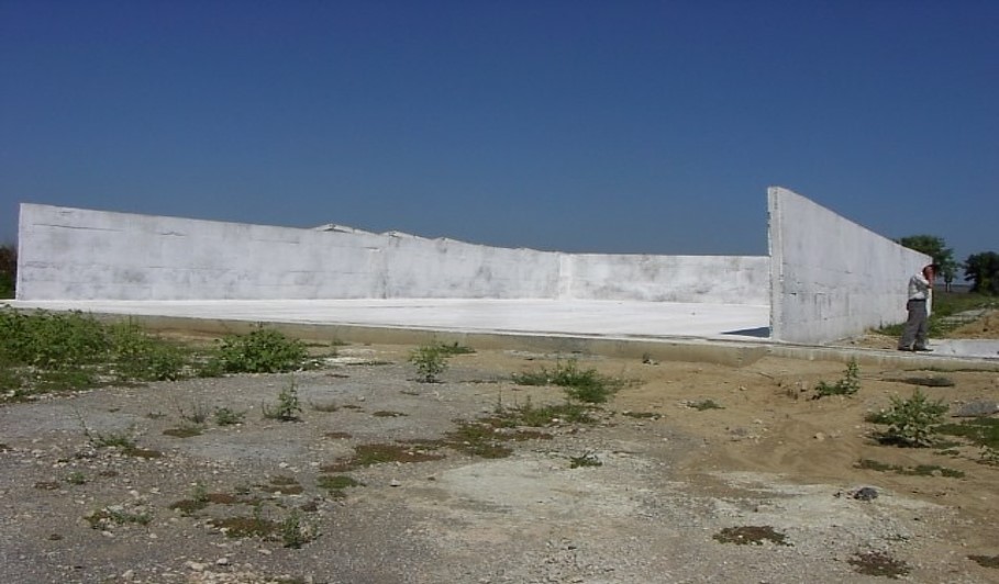
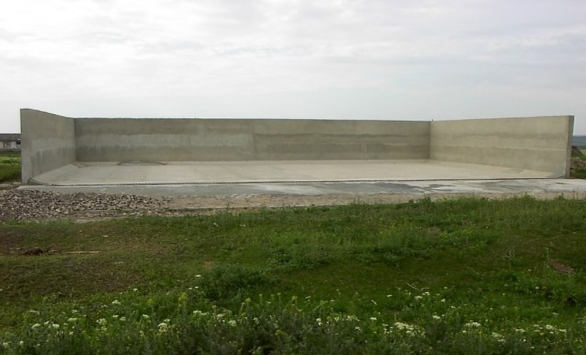
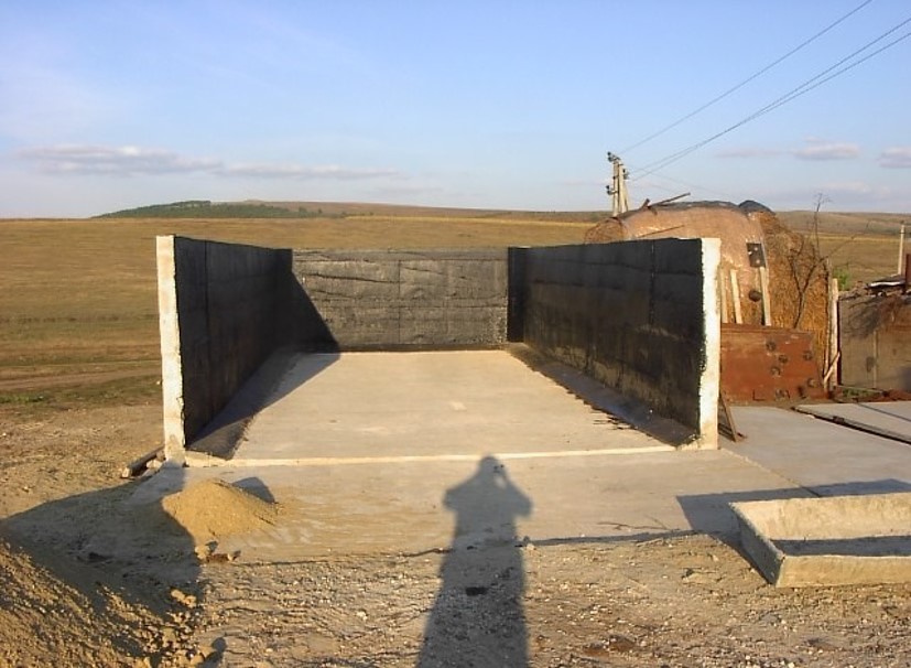
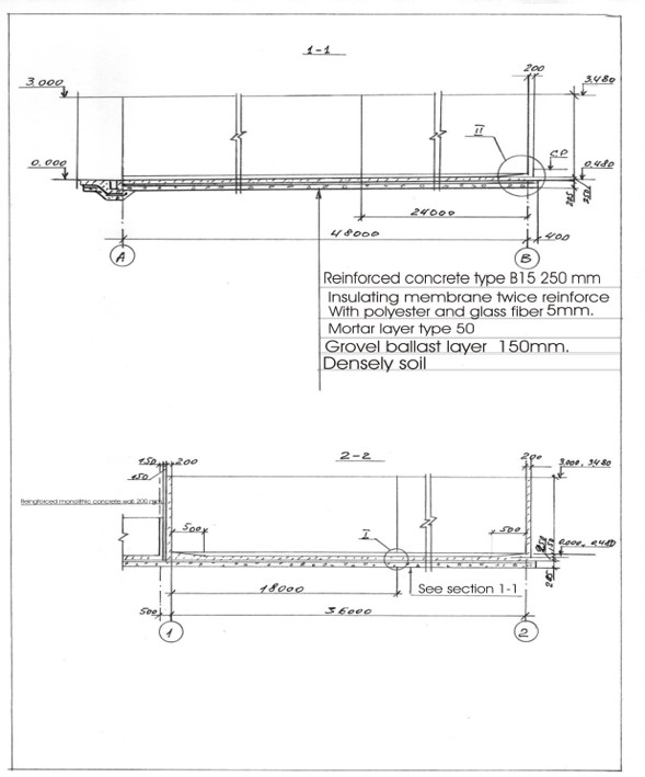
Schematic structure of village platform: Length - 48 m, Width - 36 m, Height - 3 m, Capacity - 3400 tons, Storage period - 5 months
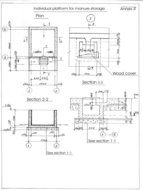
Schematic structure of household platform: Length - 2.2 m, Height - 1.2 m, Capacity - 4.8 c.m., Storage period - 1 month.
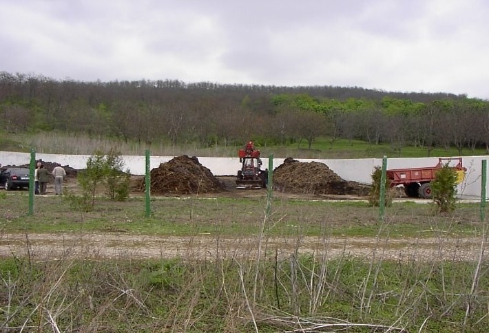
At village level, the project supported the construction of waste storage platforms of 3400 tonnes capacity and a storage period of 5 months. The platform has 48 m length and 36 m width. It is surrounded by a concrete 3 m high wall and bedded by a concrete floor with an impermeable insolating membrane. The platform is equipped with a bunker for inert material and a basin for collection of liquid fraction. The platform is built on the commune land (administrated by the Mayoralty) in full compliance with the environmental protection requirements.
At the household-level 150 platforms were built. The platforms have 2.55 m3 and a storage period of one month. The platform capacity was calculated based on estimated quantity of manure for an average household with at least two cattle, two-three pigs and a certain number of poultry. The designed platform consists of a simple open fronted store with a concrete floor and 1.5 m height walls. In front of the platform, a concrete below ground tank (125 dcm3 volume) covered by a wood lid with a plastic basket inside of 50 liters capacity for collection of liquid fraction would be equipped. A separate small capacity container (about 90 liters) for the collection of recyclable and non-recyclable household wastes was also provided.
4.4 ການສ້າງຕັ້ງກິດຈະກໍາ
| ກິດຈະກໍາ | ປະເພດ ມາດຕະການ | ໄລຍະເວລາ | |
|---|---|---|---|
| 1. | Packages developed for manure management at village and household level and evaluated for replication | ||
| 2. | Public awareness & education | ||
| 3. | Use of good agricultural practices by farmer associations, family farms and individual farmers on cropland. | ||
| 4. | Monitoring & evaluation. |
4.7 ຄ່າໃຊ້ຈ່າຍ ແລະ ປັດໄຈນໍາເຂົ້າທີ່ຈໍາເປັນສໍາລັບການບໍາລຸງຮັກສາກິດຈະກໍາ / ແຜນປະຕິບັດ (ຕໍ່ປີ)
ຖ້າຫາກຜູ້ນຳໃຊ້ທີ່ດິນ ນຳໃຊ້ມູນຄ່າຕ່ຳກວ່າ 100% ໃຫ້ລະບຸ ແມ່ນໃຜເປັນຜູ້ຊ່ວຍ ໃນລາຍຈ່າຍທີ່ເຫຼືອ:
The Project
5. ສະພາບແວດລ້ອມທໍາມະຊາດ ແລະ ມະນຸດ
5.1 ອາກາດ
ປະລິມານນໍ້າຝົນປະຈໍາປີ
- < 250 ມີລິແມັດ
- 251-500 ມີລິແມັດ
- 501-750 ມີລິແມັດ
- 751-1,000 ມີລິແມັດ
- 1,001-1,500 ມີລິແມັດ
- 1,501-2,000 ມີລິແມັດ
- 2,001-3,000 ມີລິແມັດ
- 3,001-4,000 ມີລິແມັດ
- > 4,000 ມີລິແມັດ
ໃຫ້ລະບຸສະເລ່ຍ ປະລິມານນໍ້າຝົນຕົກປະຈໍາປີ ເປັນມິນລິແມັດ (ຖ້າຫາກຮູ້ຈັກ):
500.00
ໃຫ້ລະບຸ ຊື່ສະຖານີ ອຸຕຸນິຍົມ ເພື່ອເປັນຂໍ້ມູນອ້າງອີງ:
Hincesti
ເຂດສະພາບອາກາດກະສິກໍາ
- ເຄີ່ງຄວາມຊຸ່ມ
Climate is moderately continental: the summers are warm and long, with temperatures averaging about 20°C, and the winters are relatively mild and dry, with January temperatures averaging -4°C. Annual rainfall, which ranges from around 500 millimeters; long dry spells are not unusual. The heaviest rainfall occurs in summer; heavy showers and thunderstorms are common.
5.2 ພູມິປະເທດ
ຄ່າສະເລ່ຍ ຄວາມຄ້ອຍຊັນ:
- ພື້ນທີ່ຮາບພຽງ (0-2%)
- ອ່ອນ (3-5 %)
- ປານກາງ (6-10 %)
- ມ້ວນ (11-15 %)
- ເນີນ(16-30%)
- ໍຊັນ (31-60%)
- ຊັນຫຼາຍ (>60%)
ຮູບແບບຂອງດິນ:
- ພູພຽງ / ທົ່ງພຽງ
- ສັນພູ
- ເປີ້ນພູ
- ເນີນພູ
- ຕີນພູ
- ຮ່ອມພູ
ເຂດລະດັບສູງ:
- 0-100 ແມັດ a.s.l.
- 101-500 ແມັດ a.s.l.
- 501-1,000 ແມັດ a.s.l.
- 1,001-1,500 ແມັດ a.s.l.
- 1,501-2,000 ແມັດ a.s.l.
- 2,001-2,500 ແມັດ a.s.l.
- 2,501-3,000 ແມັດ a.s.l.
- 3,001-4,000 ແມັດ a.s.l.
- > 4,000 ແມັດ a.s.l.
ໃຫ້ລະບຸ ເຕັກໂນໂລຢີ ທີ່ໄດ້ຖືກນຳໃຊ້:
- ບໍ່ກ່ຽວຂ້ອງ
ຄຳເຫັນ ແລະ ຂໍ້ມູນສະເພາະ ເພີ່ມເຕີມ ກ່ຽວກັບ ພູມີປະເທດ:
The territory belongs to the Central Moldova Height and the Plain of Upper Prut. The landscape is hilly, very fragmented with a dense network of valleys, hollows and plains. Almost 75% of the land is situated on slopes. Water erosion processes are widespread and quite intense. The predominant length of the hillsides in Negrea pilot area is 800-900 m.
5.3 ດິນ
ຄວາມເລິກ ຂອງດິນສະເລ່ຍ:
- ຕື້ນຫຼາຍ (0-20 ຊັງຕີແມັດ)
- ຕື້ນ (21-50 ຊຕມ)
- ເລີກປານກາງ (51-80 ຊຕມ)
- ເລິກ (81-120 ຊມ)
- ເລິກຫຼາຍ (> 120 cm)
ເນື້ອດິນ (ໜ້າດິນ):
- ປານກາງ (ດິນໜຽວ, ດິນໂຄນ)
ເນື້ອດິນ (ເລິກຈາກໜ້າດິນ ລົງໄປຫຼາຍກວ່າ 20 ຊັງຕິແມັດ):
- ປານກາງ (ດິນໜຽວ, ດິນໂຄນ)
ຊັ້ນອິນຊີວັດຖຸ ເທິງໜ້າດິນ:
- ປານກາງ (1-3 %)
ຖ້າເປັນໄປໄດ້ ແມ່ນໃຫ້ຕິດຄັດ ການພັນລະນາດິນ ຫຼື ຂໍ້ມູນສະເພາະຂອງດິນ, ຕົວຢ່າງ, ຄຸນລັກສະນະ ປະເພດຂອງດິນ, ຄ່າຄວາມເປັນກົດ / ເປັນດ່າງຂອງດິນ, ສານອາຫານ, ດິນເຄັມ ແລະ ອື່ນໆ.
Chernozems (black soils) prevail in the soil composition (65% of the area) divided into argilo-illuvial and carbonate subtypes. These soils are perfectly suited for agriculture. They are friable, permeable, have good water and air saturation and are easy to till. Chernozems are rich in organic matter (3-4% humus content), however they are degraded. Alluvial soils are spread in the floodplain of the Lapusna river and its tributaries. alluvial soils are often subject to salinization and water logging.
5.4 ມີນໍ້າ ແລະ ຄຸນນະພາບ
ລະດັບ ນໍ້າໃຕ້ດິນ:
5-50 ແມັດ
ການມີນໍ້າ ເທິງໜ້າດິນ:
ປານກາງ
ຄຸນນະພາບນໍ້າ (ບໍ່ມີການບໍາບັດ):
ບໍ່ມີນໍ້າດື່ມ (ຮຽກຮ້ອງໃຫ້ມີການບຳບັດນ້ຳ)
ມີບັນຫາ ກ່ຽວກັບນໍ້າເຄັມບໍ່?
ແມ່ນ
ລະບຸ ຊະນິດ:
high water mineralisation
ເກີດມີນໍ້າຖ້ວມ ໃນພື້ນທີ່ບໍ່?
ແມ່ນ
ເປັນປົກກະຕິ:
ຕອນ
5.5 ຊີວະນາໆພັນ
ຄວາມຫຼາກຫຼາຍ ທາງສາຍພັນ:
- ຕໍ່າ
ຄວາມຫຼາກຫຼາຍ ທາງດ້ານ ທີ່ຢູ່ອາໃສ ຂອງສິ່ງທີ່ມີຊີວິດ:
- ຕໍ່າ
5.6 ຄຸນລັກສະນະ ຂອງຜູ້ນໍາໃຊ້ທີ່ດິນ ທີ່ໄດ້ນໍາໃຊ້ເຕັກໂນໂລຢີ
ຢູ່ປະຈຳ ຫຼື ເຄື່ອນຍ້າຍຕະຫຼອດ:
- ບໍ່ເຄື່ອນໄຫວ
ລະບົບ ການຕະຫຼາດ ແລະ ຜົນຜະລິດ:
- ປະສົມ (ກຸ້ມຕົນເອງ / ເປັນສິນຄ້າ
ລາຍຮັບ ທີ່ບໍ່ໄດ້ມາຈາກ ການຜະລິດ ກະສິກໍາ:
- 10-50 % ຂອງລາຍຮັບທັງໝົດ
ລະດັບຄວາມຮັ່ງມີ:
- ທຸກຍາກ
- ສະເລ່ຍ
ບຸກຄົນ ຫຼື ກຸ່ມ:
- ບຸກຄົນ / ຄົວເຮືອນ
- ກຸ່ມ / ຊຸມຊົນ
ລະດັບ ການຫັນເປັນກົນຈັກ:
- ສັດລາກແກ່
- ເຄື່ອງກົນຈັກ
ເພດ:
- ຜູ້ຍິງ
- ຜູ້ຊາຍ
ອາຍຸ ຂອງຜູ້ນໍາໃຊ້ທີ່ດິນ:
- ຜູ້ສູງອາຍຸ
ໃຫ້ລະບຸ ຄຸນລັກສະນະ ຂອງຜູ້ນໍາໃຊ້ທີ່ດິນ:
The principal activity in the commune is agriculture. The farmers cultivate arable crops, grapes and fruits. From vegetables, pea and bean plantations, cabbage, cucumber, tomatoes, beats and carrots are most usual. Potatoes are predominantly cultivated on the households’ plots. There are two small economic units dealing with wood processing and meat production activating under the umbrella of the local farmer’s association, “SRL Negrea-Pomvit”. |
The income of the people depends much on the harvest and climatic conditions, but also on imbalances of the market, import policies, governmental purchases, etc. The estimated average income per capita in the community over the last 3 years was 45 US dollars per month.
5.7 ພື້ນທີ່ສະເລ່ຍຂອງທີ່ດິນ ຫຼື ເຊົ່າໂດຍຜູ້ໃຊ້ທີ່ດິນການນໍາໃຊ້ ເຕັກໂນໂລຢີ
- <0.5 ເຮັກຕາ
- 0.5-1 ເຮັກຕາ
- 1-2 ເຮັກຕາ
- 2-5 ເຮັກຕາ
- 5-15 ເຮັກຕາ
- 15-50 ເຮັກຕາ
- 50-100 ເຮັກຕາ
- 100-500 ເຮັກຕາ
- 500-1,000 ເຮັກຕາ
- 1,000-10,000 ເຮັກຕາ
- > 10,000 ເຮັກຕາ
ຖືໄດ້ວ່າ ເປັນຂະໜາດນ້ອຍ, ກາງ ຫຼື ໃຫຍ່ (ອີງຕາມເງື່ອນໄຂ ສະພາບຄວາມເປັນຈິງ ຂອງທ້ອງຖີ່ນ)? :
- ຂະໜາດກາງ
- ຂະໜາດໃຫຍ່
ຄວາມຄິດເຫັນ:
The total number of land shares in the commune is 772. Each land share has on average 1.20 ha, including 0.70 ha of arable land, 0.15 ha of orchards and 0.35 ha of vineyards. The number of individual farms is 190. The principal landowner in the region is the association of shareholders “SRL Negrea-Pomvit”. The association manages collectively 664 ha. |
5.8 ເຈົ້າຂອງທີ່ດິນ, ສິດໃຊ້ທີ່ດິນ, ແລະ ສິດທິການນໍາໃຊ້ນໍ້າ
ເຈົ້າຂອງດິນ:
- ຊຸມຊົນ / ບ້ານ
- ບຸກຄົນ, ທີ່ມີຕໍາແໜ່ງ
ສິດທິ ໃນການນໍາໃຊ້ທີ່ດິນ:
- ຊຸມຊົນ (ທີ່ມີການຈັດຕັ້ງ)
- ເຊົ່າ
ສິດທິ ໃນການນໍາໃຊ້ນໍ້າ:
- ເປີດກວ້າງ (ບໍ່ມີການຈັດຕັ້ງ)
- ບຸກຄົນ
5.9 ການເຂົ້າເຖິງການບໍລິການ ແລະ ພື້ນຖານໂຄງລ່າງ
ສຸຂະພາບ:
- ທຸກຍາກ
- ປານກາງ
- ດີ
ການສຶກສາ:
- ທຸກຍາກ
- ປານກາງ
- ດີ
ການຊ່ວຍເຫຼືອ ດ້ານວິຊາການ:
- ທຸກຍາກ
- ປານກາງ
- ດີ
ການຈ້າງງານ (ຕົວຢ່າງ, ການເຮັດກິດຈະກໍາອື່ນ ທີ່ບໍ່ແມ່ນ ການຜະລິດກະສິກໍາ):
- ທຸກຍາກ
- ປານກາງ
- ດີ
ຕະຫຼາດ:
- ທຸກຍາກ
- ປານກາງ
- ດີ
ພະລັງງານ:
- ທຸກຍາກ
- ປານກາງ
- ດີ
ຖະໜົນຫົນທາງ ແລະ ການຂົນສົ່ງ:
- ທຸກຍາກ
- ປານກາງ
- ດີ
ການດື່ມນໍ້າ ແລະ ສຸຂາພິບານ:
- ທຸກຍາກ
- ປານກາງ
- ດີ
ການບໍລິການ ທາງດ້ານການເງິນ:
- ທຸກຍາກ
- ປານກາງ
- ດີ
6. ຜົນກະທົບ ແລະ ລາຍງານສະຫຼຸບ
6.1 ການສະແດງຜົນກະທົບ ພາຍໃນພື້ນທີ່ ທີ່ໄດ້ຈັດຕັ້ງປະຕິບັດ ເຕັກໂນໂລຢີ
ຜົນກະທົບທາງເສດຖະກິດສັງຄົມ
ການຜະລິດ
ການຜະລິດພືດ
ຄວາມຄິດເຫັນ / ລະບຸແຈ້ງ:
According to elevator (NGO BIOS), •The SROI (Social Return on Investment) ratio for the period of 2004-2009 was 3,34, or, every $US1 invested by the Project $US 3,34 worth of value (economic, social and/or environmental) was delivered to society.
ຜົນຜະລິດຂອງສັດ
ຜົນຜະລິດໄມ້
ປ່າຜະລິດ
ຄວາມສ່ຽງ ຕໍ່ຜົນຜະລິດ
ການຈັດການຄຸ້ມຄອງທີ່ດິນ
ມີນໍ້າ ແລະ ຄຸນນະພາບ
ນໍ້າດື່ມ ມີຄຸນນະພາບ
ຄຸນນະພາບ ຂອງນໍ້າ ສໍາລັບລ້ຽງສັດ
ຄຸນນະພາບ ຂອງນໍ້າຊົນລະປະທານ
ຜົນກະທົບຕໍ່ລະບົບນິເວດ
ວົງຈອນນໍ້າ / ນໍ້າ
ການໄຫຼ ຂອງນໍ້າໜ້າດິນ
ດິນ
ການສູນເສຍດິນ
ການອັດແໜ້ນຂອງດິນ
ວົງຈອນ ຂອງສານອາຫານໃນດິນ
ອິນຊີວັດຖຸໃນດິນ / ຢູ່ລຸ່ມຊັ້ນດິນ C
ຊີວະນານາພັນ: ສັດ, ພືດ
ການປົກຫຸ້ມຂອງພືດ
ຄວາມຫຼາກຫຼາຍຂອງພືດ
ສາຍພັນຕ່າງຖີ່ນ
ຄວາມຫຼາກຫຼາຍ ທາງດ້ານທີ່ຢູ່ອາໃສ ຂອງສິ່ງທີ່ມີຊີວິດ
6.2 ຜົນກະທົບທາງອ້ອມ ຈາກການນໍາໃຊ້ເຕັກໂນໂລຢີ
ການທັບຖົມ ຂອງດິນຕະກອນ ຢູ່ເຂດລຸ່ມນໍ້າ
ມົນລະພິດ ທາງນໍ້າ / ນໍ້າໄຕ້ດິນ
ການປ້ອງກັນ / ຄວາມອາດສາມາດ ການກັ່ນຕອງ
ພື້ນທີ່ທໍາການຜະລິດ ຂອງເພື່ອນບ້ານທີ່ຢູ່ໃກ້ຄຽງ ໄດ້ຮັບຜົນກະທົບ
ຄວາມເສຍຫາຍ ກ່ຽວກັບພື້ນຖານໂຄງລ່າງ ສາທາລະນະ / ເອກກະຊົນ
ຄໍາເຫັນກ່ຽວກັບ ການປະເມີນ ຜົນກະທົບ:
he Social Survey indicated an improved environmental situation in LPA in comparison to other rural localities. Some problems in LPA are not so acute as there were in 2002, especially soil erosion, aquatic reservoirs pollution and quality of potable water, which demonstrates the efficiency of APCP P|
The fact that over 50 % of the respondents from Lapusnita Pilot Area consider APCP implementation has a positive impact on life, health and environment, shows that APCP contributed substantially to the improving the economic, social and ecological conditions, especially in LPA. The acknowledged impa|
It is expected that the project will be scaled up at the national level and facilities for waste management will be improved in all communities; the value of manure will be appreciated and used as fertiliser, wetlands will be restored; environment-friendly practices, including reintroducing trees wi|
The level of applied good agricultural practices in LPA is higher than in other communities of the country and has increased as compared to 2003. Farmers apply more organic fertilizers (by 13%), forest belts (10%), strip cropping (9%) and less mineral fertilizers (17%).
ACSA organized 90 seminars. People from all districts attended the training seminars. Survey data show that 90 % of the participants in seminars intended to apply GAP.
Over 3,000 farmers adopted at least 1 of GAP in Lapusnita Pilot Area and over 12,000 outside LPA. The total area, where environmentally-friendly practices were applied was 28,275 ha.
6.3 ການປ້ອງກັນ ແລະ ຄວາມບອບບາງ ຂອງເຕັກໂນໂລຢິ ໃນການປ່ຽນແປງສະພາບດິນຟ້າອາກາດ ແລະ ກ່ຽວຂ້ອງກັບອາກາດທີ່ມີການປ່ຽນແປງທີ່ຮຸນແຮງ / ໄພພິບັດທາງທໍາມະຊາດ (ຮັບຮູ້ໄດ້ໂດຍຜູ້ນໍາໃຊ້ທີ່ດິນ)
ຄວາມຄິດເຫັນ:
Healthy organisms are adapted easily to various conditions. In this way agro-ecosystems having soils and water with improved properties (due to application of good agricultural practices) with adequate management practices will have also positively impact on climate change adaptation.
Due to the fact that Good Agricultural practices improve soil and water qualities, they create very good conditions for the development of soil biodiversity and wild biodiversity in farming landscapes. Due to the reduction of pollution landscapes become more healthy and also is very beneficial for the agricultural biodiversity.
Permanent vegetated strips established at field and stream riparian boundaries and in water courses will create conditions for the development of biodiversity.|
Conventional agriculture is the major contributor to increasing of methane and nitrous oxide concentrations in earth's atmosphere. Aforestation and soil conservation technologies are one of the main sink of carbon dioxide. In this way good agricultural practices have a positively impact on climate change mitigation.
6.4 ການວິເຄາະຕົ້ນທຶນ ແລະ ຜົນປະໂຫຍດ
ຈະເຮັດປະໂຫຍດເພື່ອປຽບທຽບກັບຄ່າໃຊ້ຈ່າຍກັບສິ່ງກໍ່ສ້າງ (ຈາກທັດສະນະຂອງຜູ້ນຳໃຊ້ທີ່ດິນ) ໄດ້ແນວໃດ?
ຜົນຕອບແທນ ໃນໄລຍະສັ້ນ:
ຜົນກະທົບທາງບວກເລັກນ້ອຍ
ຜົນຕອບແທນ ໃນໄລຍະຍາວ:
ຜົນກະທົບທາງບວກ
ຈະໄດ້ຮັບຜົນປະໂຫຍດເມື່ອປຽບທຽບກັບ / ຄ່າໃຊ້ຈ່າຍໃນການບຳລຸງຮັກສາທີເ່ກີດຂື້ນອິກ (ຈາກທັດສະນະຄະຕິຂອງຜູ້ນຳໃຊ້ທີ່ດິນ) ໄດ້ແນວໃດ?
ຜົນຕອບແທນ ໃນໄລຍະສັ້ນ:
ປານກາງ
ຜົນຕອບແທນ ໃນໄລຍະຍາວ:
ຜົນກະທົບທາງບວກ
6.5 ການປັບຕົວຮັບເອົາເຕັກໂນໂລຢີ
- 10-50%
ຖ້າຫາກວ່າມີ, ປະລິມານ (ຈໍານວນຂອງຄົວເຮືອນ / ເນື້ອທີ່ການຄຸ້ມຄອງ):
8,250 farmers from both project pilot area and other regions of Moldova
ທັງໝົດນັ້ນ ແມ່ນໃຜ ທີ່ເປັນຜູ້ປັບຕົວ ໃນການນໍາໃຊ້ ເຕັກໂນໂລຢີ, ມີຈັກຄົນ ທີ່ສາມາດເຮັດເອງໄດ້, ຕົວຢ່າງ, ປາດສະຈາກ ການຊ່ວຍເຫຼືອ ທາງດ້ານອຸປະກອນ / ການຈ່າຍເປັນເງິນ?
- 10-50%
6.6 ການປັບຕົວ
ໄດ້ມີການດັດປັບ ເຕັກໂນໂລຢີ ເພື່ອໃຫ້ແທດເໝາະກັບເງື່ອນໄຂ ການປ່ຽນແປງບໍ?
ບໍ່ແມ່ນ
6.8 ຈຸດອ່ອນ / ຂໍ້ເສຍ / ຄວາມສ່ຽງ ໃນການນໍາໃຊ້ ເຕັກໂນໂລຢີ ແລະ ວິທີການແກ້ໄຂບັນຫາ
| ຈຸດອ່ອນ / ຂໍ້ເສຍ / ຄວາມສ່ຽງໃນມຸມມອງຂອງຜູ້ນໍາໃຊ້ທີ່ດິນ | ມີວິທີການແກ້ໄຂຄືແນວໃດ? |
|---|---|
| Farmers did not calculate properly expenses and benefits. | They should be provided simple instruments to calculate their inputs and to plan for future activity. |
| Agricultural literature is too difficult for rural people to understand. | Knowledge should be provided in an accessible manner. Small guides should exist for separate crops with drawings and schemes. |
7. ເອກະສານອ້າງອີງ ແລະ ການເຊື່ອມຕໍ່
7.1 ວິທີການ / ແຫຼ່ງຂໍ້ມູນ
- ການສໍາພາດ ຜູ້ນໍາໃຊ້ທີ່ດິນ
300
7.2 ເອກກະສານອ້າງອີງທີ່ເປັນບົດລາຍງານ
ຫົວຂໍ້, ຜູ້ຂຽນ, ປີ, ISBN:
Guidelines for Good Agricultural Practices (Practici agricole prietenoase mediului). Îndrumar: /Ungureanu V., Cerbari V., Magdîl A., Gherman E.- Chişinău: Tipografia Centrală, 2006. – 96 p.
ມີຢູ່ໃສ?ມູນຄ່າເທົ່າໃດ?
http://www.acsa.md/album.php?l=ro&idc=152&t=/GALERIE-FOTO/Practici-agricole-prietenoase-mediului
7.3 ສາມາດເຊື່ອມໂຍງ ຂໍ້ມູນຂ່າວສານ ໄດ້ໂດຍຜ່ານການອອນລາຍ
ຫົວຂໍ້ / ພັນລະນາ:
Moldova - Agricultural Pollution Control Project (English)
URL:
http://documents.worldbank.org/curated/en/117701468287732017/Moldova-Agricultural-Pollution-Control-Project
ຂໍ້ມູນການເຊື່ອມຕໍ່ ແລະ ເນື້ອໃນ
ຂະຫຍາຍທັງໝົດ ຍຸບທັງໝົດການເຊື່ອມຕໍ່
ບໍ່ມີຂໍ້ມູນການເຊື່ອມຕໍ່
ເນື້ອໃນ
ບໍ່ມີເນື້ອໃນ