'Forage Christine' [ເບີກິນາ ຟາໂຊ]
- ການສ້າງ:
- ປັບປູງ:
- ຜູ້ສັງລວມຂໍ້ມູນ: Nouhoun Zampaligré
- ບັນນາທິການ: –
- ຜູ້ທົບທວນຄືນ: Rima Mekdaschi Studer, Simone Verzandvoort, Donia Mühlematter, Alexandra Gavilano
Forage Christine
technologies_2994 - ເບີກິນາ ຟາໂຊ
ເບິ່ງພາກສ່ວນ
ຂະຫຍາຍທັງໝົດ ຍຸບທັງໝົດ1. ຂໍ້ມູນທົ່ວໄປ
1.2 ຂໍ້ມູນ ການຕິດຕໍ່ພົວພັນ ຂອງບຸກຄົນທີ່ສໍາຄັນ ແລະ ສະຖາບັນ ທີ່ມີສ່ວນຮ່ວມ ໃນການປະເມີນເອກກະສານ ເຕັກໂນໂລຢີ
ຊື່ໂຄງການ ທີ່ອໍານວຍຄວາມສະດວກ ໃນການສ້າງເອກກະສານ/ປະເມີນ ເຕັກໂນໂລຢີ (ຖ້າກ່ຽວຂ້ອງ)
Book project: Guidelines to Rangeland Management in Sub-Saharan Africa (Rangeland Management)ຊື່ສະຖາບັນ (ຫຼາຍສະຖາບັນ) ທີ່ອໍານວຍຄວາມສະດວກ ໃນການສ້າງເອກກະສານ / ປະເມີນ ເຕັກໂນໂລຢີ (ຖ້າກ່ຽວຂ້ອງ)
INERA Institut de l'environnement et de recherches agricoles (INERA Institut de l'environnement et de recherches agricoles) - ເບີກິນາ ຟາໂຊ1.3 ເງື່ອນໄຂ ກ່ຽວກັບ ການນໍາໃຊ້ຂໍ້ມູນເອກະສານ ທີ່ສ້າງຂື້ນ ໂດຍຜ່ານ ອົງການພາບລວມຂອງໂລກ ທາງດ້ານແນວທາງ ແລະ ເຕັກໂນໂລຢີ ຂອງການອານຸລັກ ທໍາມະຊາດ (WOCAT)
ຜູ້ປ້ອນຂໍ້ມູນ ແລະ ບຸກຄົນສຳຄັນ ທີ່ໃຫ້ຂໍ້ມູນ (ຫຼາຍ) ຍິນຍອມ ຕາມເງື່ອນໄຂ ໃນການນຳໃຊ້ຂໍ້ມູນ ເພື່ອສ້າງເປັນເອກກະສານຂອງ WOCAT:
ແມ່ນ
1.4 ແຈ້ງການວ່າ ດ້ວຍຄວາມຍືນຍົງຂອງ ເຕັກໂນໂລຢີ
ການນໍາໃຊ້ ເຕັກໂນໂລຢີ ດັ່ງກ່າວໄດ້ອະທິບາຍ ເຖິງບັນຫາ ກ່ຽວກັບ ການເຊື່ອມໂຊມຂອງດິນບໍ? ຖ້າບໍ່ດັ່ງນັ້ນ ມັນບໍ່ສາມາດ ຢັ້ງຢືນໄດ້ວ່າ ເປັນເຕັກໂນໂລຊີ ໃນການຄຸ້ມຄອງ ທີ່ດິນແບບຍືນຍົງ? :
ບໍ່ແມ່ນ
2. ການອະທິບາຍ ເຕັກໂນໂລຢີ ຂອງການຄຸ້ມຄອງ ທີ່ດິນແບບຍືນຍົງ
2.1 ຄໍາອະທິບາຍສັ້ນຂອງ ເຕັກໂນໂລຢີ
ການກຳໜົດຄວາມໝາຍ ຂອງເຕັກໂນໂລຢີ:
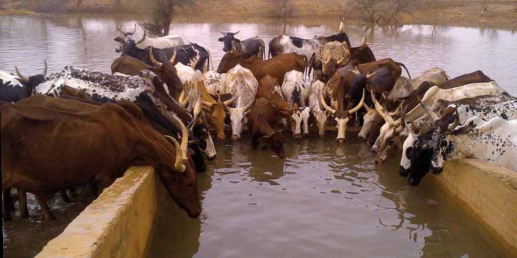
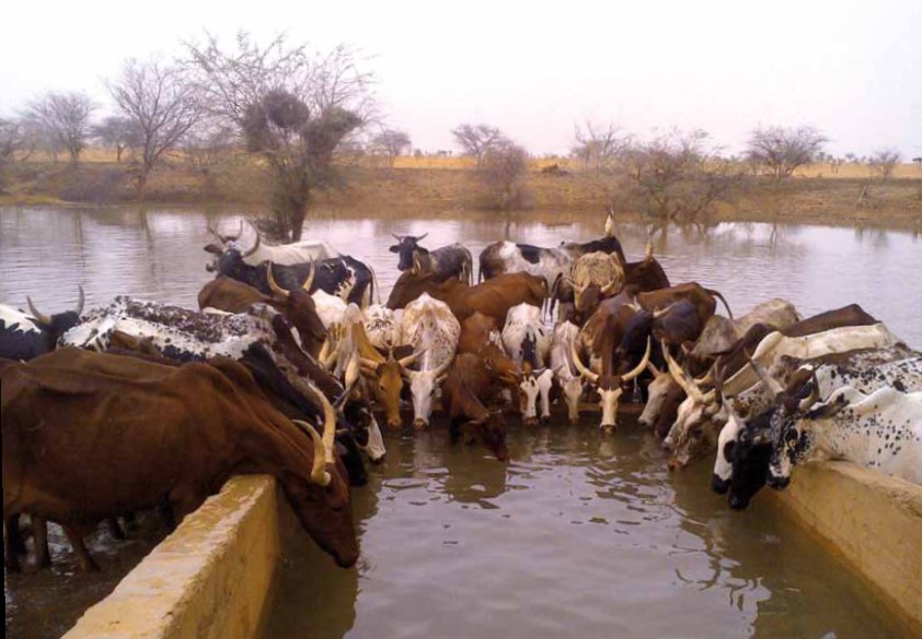
A modern hydraulic complex in the centre of the Sahelian region of Burkina Faso for watering livestock in the dry season.
2.2 ການອະທິບາຍ ລາຍລະອຽດ ຂອງເຕັກໂນໂລຢີ
ການພັນລະນາ:
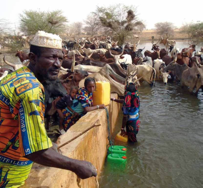
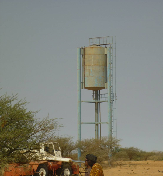
The well called 'Forage Christine' was constructed in 1971 by a French engineer, which named it after his wife, and opened it for the first time in 1972. Due to conflicts between Burkina and Mali it was ruined in 1976, and then again in 1985. In 1996 the National Office for Wells and Boreholes (ONFP), a government agency, rehabilitated the well and made two supplementary boreholes. The complex consists of a main well with an operating flow rate of 120 m3/h, having a submersible pump of brand KSB, type OPA 150s-65/8, and a pump capacity of 60 m3/h. Next to the main well there is a secondary well, which is equipped with a hand-operated pump with a capacity of 18 m3/h.
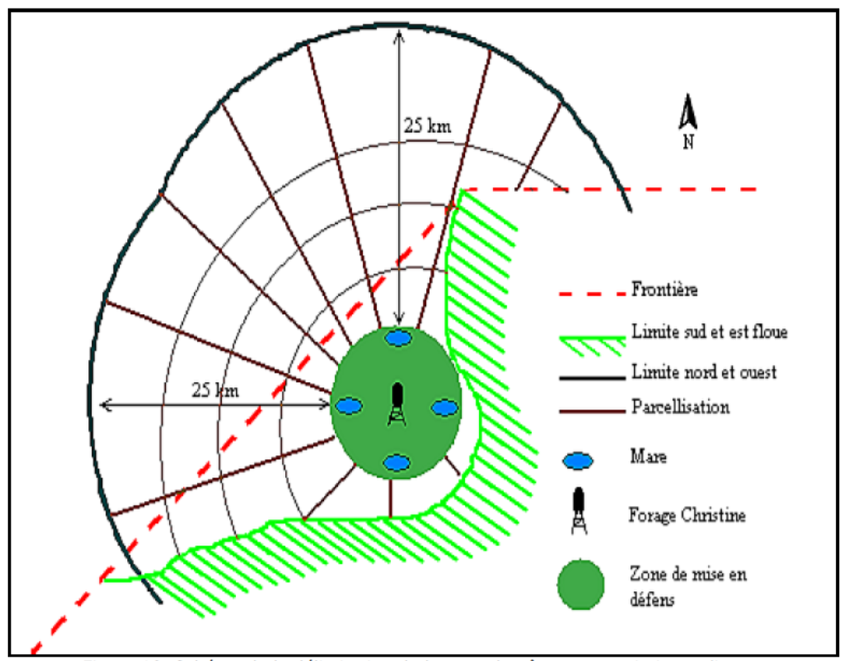
The energy for pumping water from the wells is provided by a generator with an engine of brand DEUTZ (type: F3 - 6L 912) and a switch of brand LEROY SOMER – Type LSA 42.1 L8L C1/4, a voltage of 400 V and continuous power of 50 kW. The generator has a switch and a battery. A diesel tank with a volume of approximately 9 m3 was installed for the power supply to the generator. The pumped water is stored in an elevated water tank, which is located at a distance of about 200 m from the well, and has a volume of 50 m3. The water from the elevated water tank is distributed to four artificial ponds with a dimension of 50 m x 50 m x 1.5 m at equal distances on all sides of the central reservoir. The water is conducted to the artificial ponds through PVC piping, which is buried underground over a distance of 8 km, or 2 km for each pond. The water flow is controlled by nine valves of type Nr. 4000, Reg. Nr. W 1.129, installed on the pipes. The hydraulic complex was installed in 1996 by the National Agency for Water and Sanitation (ONEA). The complex is managed by the livestock keepers through the User Association of 'Forage Christine' (AUFC). The statutes of this organisation were adopted on 2 May 2014. The well is managed according to a set of requirements which specify the terms for access to water: date of opening and closure of the well, the amount to be paid per animal and the management of the cash money provided.
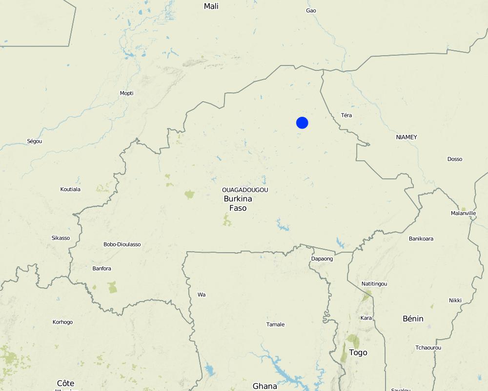
'Forage Christine' is a major water infrastructure, established in the northern part of the Sahel region in Burkina Faso between longitude 0°45’W and latitude 14°48’N, providing drinking water to herds within an area of 100 to 300 km from its central location between Burkina Faso, Mali and Niger. It was established in 1971 in the context of major droughts that had affected the Sahel, and it was opened for the first time in 1972. It is located in the middle of the Sahel region of Burkina Faso, at two km from the pond of Tin-Arkachen in the department of Déou, at approximately 45 km from the capital of the department, and 85 km from Gorom-Gorom. At the sub-regional level, the well is a around ten km from the border with Mali, and at 100 km from the border with Niger. The climate is of Sahelian type, and has a rainy season of 3 to 4 months (from June-July to September), which is subject to strong temporal and spatial variations in precipitation, and a dry season of 8 to 9 months. The climatic conditions are characterized by highly irregular winds, precipitation, evapotranspiration and moisture due to fluctuations in atmospheric circulation patterns. Annual precipitation is around 500 mm on average, with roughly 30 rainy days, and is marked by significant inter-annual variations. The stream network of the region consists of several streams, with one permanent river: Béli. To this river, ponds and many depressions are connected, which disappear after the month of January. The soils are very diverse in general, and mostly of sandy texture. They do not provide a good medium for plant growth due to the low permeability, which reduces water infiltration. Therefore water availability appears to be one of the major limitations for rainfed agriculture, in addition to the limited retention and availability of nutrients. According to the phytogeographic division of Burkina Faso (Fontes and Guinko, 1995), the area of 'Forage Christine' is situated in the northern or strict Sahelian phytogeographic sector. This sector is characterized by a set of typical Saharan and Sahelian vegetation species which mainly occur in shrub and woody steppes (48.85%) and grassy steppes (24.37%), which form the larger part of the rangelands (***). This vegetation provides the most important natural grazing land to livestock.
With regard to the human environment, the last General Population and Housing Census mentions a population of 25321 inhabitants for the municipality of Déou. Yet this number varies significantly due to the seasonal migration of people from other regions to use water and forage resources. The ethnic groups in the region are mainly Fulbé, Kurumba, Songhai, Tuareg, Mossi and Hausa people.
Economic activities in the region are livestock keeping, farming, craftmanship, fishing, trade, tourism and hunting. Several socio-economic groups are guiding these activities. Some 60 farmer groups, 53 groups of livestock keepers, six of which for female livestock keepers, and three organisations for environmental protection. With regard to infrastructure for education, sanitation and socio-economical conditions, the municipality of Déou has three markets, 18 schools, one middle school, 47 permanent functional literacy centers (CPAF), one recreation center, six cereal banks, three healthcare and welfare centers (CSPS), three medical stores, one tourist camp and one financial institution.
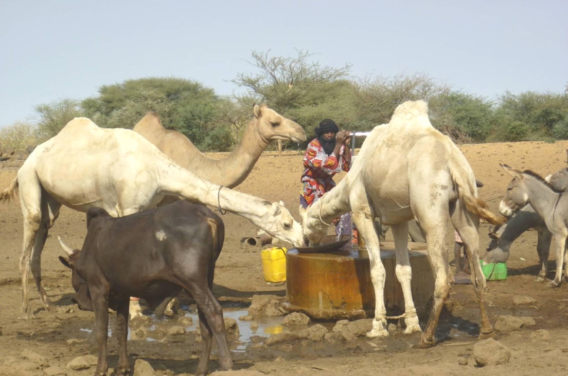
Farming and livestock keeping continue to be the most important socio-economic activities. The agricultural crops produced include millet, sorghum, maize, cowpea, rice and groundnut. In 2009, a total area of 345.5 ha was sown for these crops. The Sahel region in Burkina Faso has excellent conditions for livestock keeping. The animal species found in the region are mainly cattle, sheep, goats, pigs, camels, donkeys and horses and poultry. Several facilities and installations for water supply to pastoral areas are available in the region, as well as storage facilities for agricultural and agro-industrial by-products (SPAI) and infrastructure for trade and animal health care. The municipality of Déou disposes of one reservoir, five artificial ponds, 43 firm wells, ten vaccination centers, one store for agricultural and agro-industrial by-products (SPAI), one animal shelter, a facility for slaughtering and a livestock market.
2.3 ຮູບພາບຂອງເຕັກໂນໂລຢີ
ສື່ຮູບພາບ
ຂໍ້ສັງເກດທົ່ວໄປທີ່ກ່ຽວກັບຮູບພາບ:
The dates of the picture and the photographer are unknown.
2.4 ວິດີໂອ ເຕັກໂນໂລຢີ
ຄວາມຄິດເຫັນ, ຄໍາອະທິບາຍຫຍໍ້:
No video
2.5 ປະເທດ / ເຂດ / ສະຖານທີ່ບ່ອນທີ່ ເຕັກໂນໂລຢີ ໄດ້ຮັບການນໍາໃຊ້ ແລະ ທີ່ຖືກປົກຄຸມດ້ວຍການປະເມີນຜົນ
ປະເທດ:
ເບີກິນາ ຟາໂຊ
ພາກພື້ນ / ລັດ / ແຂວງ:
Sahel/Oudalan
ຂໍ້ມູນເພີ່ມເຕີມຂອງສະຖານທີ່:
Déou
ໃຫ້ລະບຸ ການແຜ່ຂະຫຍາຍ ເຕັກໂນໂລຢີ:
- ນໍາໃຊ້ໃນຈຸດສະເພາະ / ແນໃສ່ນໍາໃຊ້ໃນພື້ນທີ່ຂະໜາດນ້ອຍ
ຄວາມຄິດເຫັນ:
The infrastructure was created in 1971, but the facilities for use were installed in 1996.
The well is located in the municipality of Déou, but is used for livestock from the entire Sahel region in Burkina Faso, Mali and Niger.
Map
×2.6 ວັນທີໃນການຈັດຕັ້ງປະຕິບັດ
ໃຫ້ລະບຸປີ ໃນການຈັດຕັ້ງປະຕິບັດ:
1971
2.7 ການນໍາສະເໜີ ເຕັກໂນໂລຢີ
ໃຫ້ລະບຸ ເຕັກໂນໂລຢີ ໄດ້ຖືກຈັດຕັ້ງປະຕິບັດຄືແນວໃດ?
- ໂດຍຜ່ານໂຄງການ / ການຊ່ວຍເຫຼືອຈາກພາຍນອກ
ຄວາມຄິດເຫັນ (ປະເພດ ໂຄງການ ແລະ ອື່ນໆ):
A French aid worker introduced the technology with support from the government of Burkina Faso, through the National Agency for Water and Sanitation (ONEA).
3. ການໃຈ້ແຍກ ເຕັກໂນໂລຢີ ໃນການຄຸ້ມຄອງ ດິນແບບຍືນຍົງ
3.1 ຈຸດປະສົງຫຼັກ (ຫຼາຍ) ຂອງເຕັກໂນໂລຢີ
- ປັບຕົວຕໍ່ກັບການປ່ຽນແປງດິນຟ້າອາກາດ / ທີ່ຮ້າຍແຮງ ແລະ ຜົນກະທົບ
- ສ້າງຜົນກະທົບ ທາງເສດຖະກິດ ທີ່ເປັນປະໂຫຍດ
- ສ້າງຜົນກະທົບ ທີ່ເປັນທາງບວກ ໃຫ້ແກ່ສັງຄົມ
3.2 ປະເພດການນໍາໃຊ້ທີ່ດິນ ໃນປະຈຸບັນ() ທີ່ເຕັກໂນໂລຢີ ໄດ້ຖືກນໍາໃຊ້
ການນຳໃຊ້ທີ່ດິນ ປະສົມພາຍໃນພື້ນທີ່ດຽວກັນ:
ແມ່ນ
ລະບຸການນຳໃຊ້ທີ່ດິນແບບປະສົມ (ຜົນລະປູກ / ທົ່ງຫຍ້າລ້ຽງສັດ / ຕົ້ນໄມ້):
- ກະສິກໍາແບບປະສົມປະສານ (ລວມທັງ ການລ້ຽງສັດ-ປຸກຝັງ)

ດິນທີ່ປູກພືດ
- ການປູກພືດປະຈໍາປີ
ການປູກພືດປະຈຳປີ - ລະບຸປະເພດພືດ:
- ພືດປະເພດເມັດໃຫ້ນ້ຳມັນ-ຖົ່ວດິນ
- ທັນຍາພືດ-ເຂົ້າຟາງ
- ທັນຍາພືດ-ເຂົ້າຟາງ
- ພືດຕະກູນຖົ່ວ ແລະ ຖົ່ວແປກ
ຈໍານວນ ລະດູການ ປູກໃນປີໜຶ່ງ:
- 1
ລະບຸ ຊະນິດ:
Mid-June to September

ທົ່ງຫຍ້າລ້ຽງສັດ
ການລ້ຽງສັດແບບປ່ອຍ ຕາມທຳມະຊາດ:
- ການລ້ຽງສັດແບບເຄີ່ງປ່ອຍ
ປະເພດສັດ:
- ສັດໃຫ່ຍ-ງົວພັນຊີ້ນ
- ແບ້
- ອູດ
- ໂຕລໍ ແລະ ໂຕລາ
- ແກະ
ຄວາມຄິດເຫັນ:
In addition to livestock keeping, subsistence farming is practiced. The main crops are sorghum, millet, groundnut and cowpea. The size of the fields varies between 0.5 and 3 ha. The farm type is family-based.
Animal species: cattle, sheep, camels, donkeys and goats.
3.3 ການນຳໃຊ້ທີ່ດິນ ມີການປ່ຽນແປງຍ້ອນການຈັດຕັ້ງທົດລອງເຕັກໂນໂລຢີ ແມ່ນບໍ່?
ການນຳໃຊ້ທີ່ດິນ ມີການປ່ຽນແປງຍ້ອນການຈັດຕັ້ງທົດລອງເຕັກໂນໂລຢີ ແມ່ນບໍ່?
- ບໍ່ (ຕໍ່ເໜືອງກັບ ຄຳຖາມ 3.4)
3.4 ການສະໜອງນ້ຳ
ການສະໜອງນໍ້າ ໃນພື້ນທີ່ ທີ່ໄດ້ນໍາໃຊ້ ເຕັກໂນໂລຢີ:
- ນໍ້າຝົນ
3.5 ການນໍາໃຊ້ເຕັກໂນໂລຢີ ທີ່ຢູ່ໃນກຸ່ມການຄຸ້ມຄອງ ທີ່ດິນແບບຍືນຍົງ
- ການຄຸ້ມຄອງສັດລ້ຽງ ແລະ ທົ່ງຫຍ້າລ້ຽງສັດ
- ການຈັດການນໍ້າໄຕ້ດິນ
3.6 ມາດຕະການ ການຄຸ້ມຄອງ ທີ່ດິນແບບຍືນຍົງ ປະກອບດ້ວຍ ເຕັກໂນໂລຢີ

ມາດຕະການໂຄງສ້າງ
- S7: ອຸປະກອນເກັບຮັກສາ, ສະໜອງນ້ຳ, ຊົນລະປະທານ
3.7 ປະເພດດິນເຊື່ອມໂຊມ ຫຼັກທີ່ໄດ້ນໍາໃຊ້ ເຕັກໂນໂລຢີ

ການເຊື່ອມໂຊມ ຂອງນໍ້າ
- Ha: ສະພາບແຫ້ງແລ້ງ
- Hs: ການປ່ຽນແປງ ປະລິມານ ນໍ້າໜ້າດິນ
- Hg: ການປ່ຽນແປງ ລະດັບນ້ຳໃຕ້ດິນ ຫຼື ນ້ຳບາດານ
- Hp: ຄຸນນະພາບ ຂອງນ້ຳຊັ້ນໜ້າດິນຫຼຸດລົງ

ອື່ນໆ
ຄວາມຄິດເຫັນ:
The technology aims to remediate water scarcity for livestock during the dry season.
3.8 ການປ້ອງກັນ, ການຫຼຸດຜ່ອນ, ຫຼືການຟື້ນຟູຂອງການເຊື່ອມໂຊມຂອງດິນ
ໃຫ້ລະບຸ ເປົ້າໝາຍ ເຕັກໂນໂລຢີ ທີ່ພົວພັນ ກັບຄວາມເຊື່ອມໂຊມຂອງດິນ:
- ຫຼຸດຜ່ອນການເຊື່ອມໂຊມຂອງດິນ
4. ຂໍ້ກໍາໜົດ, ກິດຈະກໍາການປະຕິບັດ, ວັດຖຸດິບ, ແລະຄ່າໃຊ້ຈ່າຍ
4.1 ເຕັກນິກ ໃນການແຕ້ມແຜນວາດ ເຕັກໂນໂລຢີ
ຄຸນລັກສະນະ ຂອງເຕັກນິກ (ທີ່ກ່ຽວຂ້ອງ ກັບການແຕ້ມແຜນວາດ ທາງດ້ານເຕັກນີກ):
1. Main well, flow rate 120 m3/h.
2. Secondary well, flow rate 18 m3/h.
3. Submersible pump, brand KSB, type OPA 150s-65/8, flow rate 60m3/h, year of constrcuction1996
4. Elevated water storage tank, volume 50 m3.
5. Four ponds of 50 m x 50 m x 1.5 m.
ຜູ້ຂຽນ:
SNV
4.2 ຂໍ້ມູນທົ່ວໄປກ່ຽວກັບການຄິດໄລ່ປັດໃຈຂາເຂົ້າໃນການຜະລິດ ແລະ ມູນຄ່າອື່ນໆ
ລະບຸ ວິທີການ ຄຳໃຊ້ຈ່າຍ ແລະ ປັດໄຈນໍາເຂົ້າ ທີ່ໄດ້ຄິດໄລ່:
- ຕໍ່ຫົວໜ່ວຍ ທີ່ໄດ້ຈັດຕັ້ງປະຕິບັດ ເຕັກໂນໂລຢີ
ສະກຸນເງິນອື່ນໆ / ປະເທດອື່ນໆ (ລະບຸ):
FCFA
ຖ້າກ່ຽວຂ້ອງ, ໃຫ້ລະບຸອັດຕາແລກປ່ຽນຈາກ USD ເປັນສະກຸນເງິນທ້ອງຖິ່ນ (ເຊັ່ນ: 1 USD = 79.9 Brazilian Real): 1 USD =:
550.0
ລະບຸ ຄ່າຈ້າງ ຄ່າແຮງງານສະເລ່ຍ ຕໍ່ ວັນ:
35 000 per month
4.3 ການສ້າງຕັ້ງກິດຈະກໍາ
| ກິດຈະກໍາ | Timing (season) | |
|---|---|---|
| 1. | Main well | |
| 2. | Elevated water storage tank | |
| 3. | Artificial ponds |
ຄວາມຄິດເຫັນ:
Not evaluated.
4.4 ຕົ້ນທຶນ ແລະ ປັດໄຈຂາເຂົ້າທີ່ຈໍາເປັນໃນຈັດຕັ້ງປະຕິບັດ
ຄວາມຄິດເຫັນ:
Not applicable.
4.5 ບໍາລຸງຮັກສາ / ແຜນຈັດຕັ້ງປະຕິບັດ ກິດຈະກໍາ
| ກິດຈະກໍາ | ໄລຍະເວລາ / ຄວາມຖີ່ | |
|---|---|---|
| 1. | Use of diesel | year |
| 2. | Use of oil and filters | year |
| 3. | Periodic maintenance of the generator | year |
| 4. | Fuel delivery | year |
| 5. | Transport costs of the maintenance operator | year |
| 6. | Wage of the guard | year |
| 7. | Compensation of the manager of the generator | year |
| 8. | Charges for accounting | year |
4.6 ຄ່າໃຊ້ຈ່າຍ ແລະ ປັດໄຈນໍາເຂົ້າທີ່ຈໍາເປັນສໍາລັບການບໍາລຸງຮັກສາກິດຈະກໍາ / ແຜນປະຕິບັດ (ຕໍ່ປີ)
| ລະບຸ ປັດໃຈ ນໍາເຂົ້າ ໃນການຜະລີດ | ຫົວໜ່ວຍ | ປະລິມານ | ຕົ້ນທຶນ ຕໍ່ຫົວໜ່ວຍ | ຕົ້ນທຶນທັງໝົດ ຂອງປັດໃຈຂາເຂົ້າ ໃນການຜະລິດ | % ຂອງຕົ້ນທຶນທັງໝົດ ທີ່ຜູ້ນໍາໃຊ້ທີ່ດິນ ໃຊ້ຈ່າຍເອງ | |
|---|---|---|---|---|---|---|
| ແຮງງານ | Periodic maintenance of the generator | season | 1.0 | 150000.0 | 150000.0 | |
| ແຮງງານ | Compensation of the GE manager | person-month | 12.0 | 37500.0 | 450000.0 | |
| ແຮງງານ | Charges for accounting | person-month | 12.0 | 175.0 | 2100.0 | |
| ແຮງງານ | Wage of the guard | person-month | 12.0 | 50000.0 | 600000.0 | |
| ອື່ນໆ | Use of diesel | season | 1.0 | 2921000.0 | 2921000.0 | |
| ອື່ນໆ | Use of oil, filters | season | 1.0 | 68000.0 | 68000.0 | |
| ອື່ນໆ | Reparations to the hydraulic complex | season | ||||
| ອື່ນໆ | Fuel delivery | season | 1.0 | 125000.0 | 125000.0 | |
| ອື່ນໆ | Transport costs of maintenance operator | season | 1.0 | 60000.0 | 60000.0 | |
| ຕົ້ນທຶນທັງໝົດ ທີ່ໃຊ້ໃນການບໍາລຸງຮັກສາ ເຕັກໂນໂລຢີ | 4376100.0 | |||||
| ຄ່າໃຊ້ຈ່າຍທັງໝົດ ສຳລັບການບົວລະບັດຮກສາເຕັກໂນໂລຢີ ເປັນສະກຸນເງີນໂດລາ | 7956.55 | |||||
ຖ້າຫາກຜູ້ນຳໃຊ້ທີ່ດິນ ນຳໃຊ້ມູນຄ່າຕ່ຳກວ່າ 100% ໃຫ້ລະບຸ ແມ່ນໃຜເປັນຜູ້ຊ່ວຍ ໃນລາຍຈ່າຍທີ່ເຫຼືອ:
The municipality, the management committee and the NGOs operating in the area (SNV).
4.7 ປັດໄຈ ທີ່ສໍາຄັນ ທີ່ສົ່ງຜົນກະທົບ ຕໍ່ຄ່າໃຊ້ຈ່າຍ
ໃຫ້ອະທິບາຍ ປັດໃຈ ທີ່ສົ່ງຜົນກະທົບ ຕໍ່ຕົ້ນທຶນ ໃນການຈັດຕັ້ງປະຕິບັດ:
1. Availability of fuel for the generator.
2. Failures in the functioning of the generator to fill the storage tanks.
5. ສະພາບແວດລ້ອມທໍາມະຊາດ ແລະ ມະນຸດ
5.1 ອາກາດ
ປະລິມານນໍ້າຝົນປະຈໍາປີ
- < 250 ມີລິແມັດ
- 251-500 ມີລິແມັດ
- 501-750 ມີລິແມັດ
- 751-1,000 ມີລິແມັດ
- 1,001-1,500 ມີລິແມັດ
- 1,501-2,000 ມີລິແມັດ
- 2,001-3,000 ມີລິແມັດ
- 3,001-4,000 ມີລິແມັດ
- > 4,000 ມີລິແມັດ
ໃຫ້ລະບຸສະເລ່ຍ ປະລິມານນໍ້າຝົນຕົກປະຈໍາປີ ເປັນມິນລິແມັດ (ຖ້າຫາກຮູ້ຈັກ):
500.00
ຂໍ້ມູນສະເພາະ / ຄວາມເຫັນກ່ຽວກັບ ປະລິມານນໍ້າຝົນ:
Mean annual rainfall is around 500 mm, with approximately 30 rainy days and characterized by a strong variation between years. The water system has many streams, of which only one is permanent (the Béli river). To this river, ponds and many depressions are connected, which disappear after the month of January.
ໃຫ້ລະບຸ ຊື່ສະຖານີ ອຸຕຸນິຍົມ ເພື່ອເປັນຂໍ້ມູນອ້າງອີງ:
Station of Gorom-Gorom
ເຂດສະພາບອາກາດກະສິກໍາ
- ເຄິ່ງແຫ້ງແລ້ງ
The climate is of Sahelian type, and has a rainy season of 3 to 4 months (from June-July to September), which is subject to strong temporal and spatial variations in precipitation, and a dry season of 8 to 9 months. The climatic conditions are characterized by highly irregular winds, precipitation, evapotranspiration and moisture due to fluctuations in atmospheric circulation patterns.
5.2 ພູມິປະເທດ
ຄ່າສະເລ່ຍ ຄວາມຄ້ອຍຊັນ:
- ພື້ນທີ່ຮາບພຽງ (0-2%)
- ອ່ອນ (3-5 %)
- ປານກາງ (6-10 %)
- ມ້ວນ (11-15 %)
- ເນີນ(16-30%)
- ໍຊັນ (31-60%)
- ຊັນຫຼາຍ (>60%)
ຮູບແບບຂອງດິນ:
- ພູພຽງ / ທົ່ງພຽງ
- ສັນພູ
- ເປີ້ນພູ
- ເນີນພູ
- ຕີນພູ
- ຮ່ອມພູ
ເຂດລະດັບສູງ:
- 0-100 ແມັດ a.s.l.
- 101-500 ແມັດ a.s.l.
- 501-1,000 ແມັດ a.s.l.
- 1,001-1,500 ແມັດ a.s.l.
- 1,501-2,000 ແມັດ a.s.l.
- 2,001-2,500 ແມັດ a.s.l.
- 2,501-3,000 ແມັດ a.s.l.
- 3,001-4,000 ແມັດ a.s.l.
- > 4,000 ແມັດ a.s.l.
5.3 ດິນ
ຄວາມເລິກ ຂອງດິນສະເລ່ຍ:
- ຕື້ນຫຼາຍ (0-20 ຊັງຕີແມັດ)
- ຕື້ນ (21-50 ຊຕມ)
- ເລີກປານກາງ (51-80 ຊຕມ)
- ເລິກ (81-120 ຊມ)
- ເລິກຫຼາຍ (> 120 cm)
ເນື້ອດິນ (ໜ້າດິນ):
- ຫຍາບ / ເບົາ (ດິນຊາຍ)
ເນື້ອດິນ (ເລິກຈາກໜ້າດິນ ລົງໄປຫຼາຍກວ່າ 20 ຊັງຕິແມັດ):
- ຫຍາບ / ເບົາ (ດິນຊາຍ)
ຊັ້ນອິນຊີວັດຖຸ ເທິງໜ້າດິນ:
- ຕໍາ່ (<1 %)
ຖ້າເປັນໄປໄດ້ ແມ່ນໃຫ້ຕິດຄັດ ການພັນລະນາດິນ ຫຼື ຂໍ້ມູນສະເພາະຂອງດິນ, ຕົວຢ່າງ, ຄຸນລັກສະນະ ປະເພດຂອງດິນ, ຄ່າຄວາມເປັນກົດ / ເປັນດ່າງຂອງດິນ, ສານອາຫານ, ດິນເຄັມ ແລະ ອື່ນໆ.
The soils are very diverse in general, and mostly of sandy texture. They do not provide a good medium for plant growth due to the low permeability, which reduces water infiltration.
5.4 ມີນໍ້າ ແລະ ຄຸນນະພາບ
ລະດັບ ນໍ້າໃຕ້ດິນ:
ເທິງຊັ້ນໜ້າດິນ
ການມີນໍ້າ ເທິງໜ້າດິນ:
ທຸກຍາກ / ບໍ່ມີ
ຄຸນນະພາບນໍ້າ (ບໍ່ມີການບໍາບັດ):
ບໍ່ມີນໍ້າດື່ມ (ຮຽກຮ້ອງໃຫ້ມີການບຳບັດນ້ຳ)
ມີບັນຫາ ກ່ຽວກັບນໍ້າເຄັມບໍ່?
ບໍ່ແມ່ນ
ເກີດມີນໍ້າຖ້ວມ ໃນພື້ນທີ່ບໍ່?
ບໍ່ແມ່ນ
ຄວາມຄິດເຫັນ ແລະ ຂໍ້ກໍານົດ ເພີ່ມເຕີມ ກ່ຽວກັບ ຄຸນນະພາບ ແລະ ປະລິມານ ຂອງນ້ຳ:
Limited water availability appears to be one of the major limitations for rainfed agriculture, in addition to the low retention and availability of nutrients.
5.5 ຊີວະນາໆພັນ
ຄວາມຫຼາກຫຼາຍ ທາງສາຍພັນ:
- ປານກາງ
ຄວາມຫຼາກຫຼາຍ ທາງດ້ານ ທີ່ຢູ່ອາໃສ ຂອງສິ່ງທີ່ມີຊີວິດ:
- ຕໍ່າ
ຄວາມຄິດເຫັນ ແລະ ລັກສະນະສະເພາະ ເພີ່ມເຕີມກ່ຽວກັບ ຊີວະນາໆພັນ:
The area around the 'Forage Christine' is characterized by a variety of typical Saharan and Sahelian vegetation units which mainly occur in shrub and woody steppes (48.85%) and grassy steppes (24.37%), and which form the larger part of the rangelands.
5.6 ຄຸນລັກສະນະ ຂອງຜູ້ນໍາໃຊ້ທີ່ດິນ ທີ່ໄດ້ນໍາໃຊ້ເຕັກໂນໂລຢີ
ຢູ່ປະຈຳ ຫຼື ເຄື່ອນຍ້າຍຕະຫຼອດ:
- ບໍ່ເຄື່ອນໄຫວ
- ແບບເຄີ່ງຂັງ-ເຄີ່ງປ່ອຍ
ລະບົບ ການຕະຫຼາດ ແລະ ຜົນຜະລິດ:
- ກຸ້ມຕົນເອງ (ພໍພຽງ)
ລາຍຮັບ ທີ່ບໍ່ໄດ້ມາຈາກ ການຜະລິດ ກະສິກໍາ:
- ໜ້ອຍກ່ວາ 10 % ຂອງລາຍຮັບທັງໝົດ
ລະດັບຄວາມຮັ່ງມີ:
- ທຸກຍາກຫຼາຍ
- ທຸກຍາກ
ບຸກຄົນ ຫຼື ກຸ່ມ:
- ບຸກຄົນ / ຄົວເຮືອນ
- ກຸ່ມ / ຊຸມຊົນ
ລະດັບ ການຫັນເປັນກົນຈັກ:
- ການໃຊ້ແຮງງານຄົນ
- ສັດລາກແກ່
ເພດ:
- ຜູ້ຍິງ
- ຜູ້ຊາຍ
ອາຍຸ ຂອງຜູ້ນໍາໃຊ້ທີ່ດິນ:
- ຊາວໜຸ່ມ
- ໄວກາງຄົນ
ໃຫ້ລະບຸ ຄຸນລັກສະນະ ຂອງຜູ້ນໍາໃຊ້ທີ່ດິນ:
Several socio-economic groups are guiding the activities of land users. These include 60 farmer groups, 53 groups of livestock keepers, six of which for female livestock keepers, and three organisations for environmental protection.
5.7 ເນື້ອທີ່ສະເລ່ຍຂອງດິນ ທີ່ຜູ້ນຳໃຊ້ທີ່ດິນ ໃຊ້ເຮັດເຕັກໂນໂລຢີ
- <0.5 ເຮັກຕາ
- 0.5-1 ເຮັກຕາ
- 1-2 ເຮັກຕາ
- 2-5 ເຮັກຕາ
- 5-15 ເຮັກຕາ
- 15-50 ເຮັກຕາ
- 50-100 ເຮັກຕາ
- 100-500 ເຮັກຕາ
- 500-1,000 ເຮັກຕາ
- 1,000-10,000 ເຮັກຕາ
- > 10,000 ເຮັກຕາ
ຖືໄດ້ວ່າ ເປັນຂະໜາດນ້ອຍ, ກາງ ຫຼື ໃຫຍ່ (ອີງຕາມເງື່ອນໄຂ ສະພາບຄວາມເປັນຈິງ ຂອງທ້ອງຖີ່ນ)? :
- ຂະໜາດນ້ອຍ
- ຂະໜາດກາງ
ຄວາມຄິດເຫັນ:
Most of the agro pastoralist are smallholder farmers, livestock keeping is their main livelihood activity.
5.8 ເຈົ້າຂອງທີ່ດິນ, ສິດໃຊ້ທີ່ດິນ, ແລະ ສິດທິການນໍາໃຊ້ນໍ້າ
ເຈົ້າຂອງດິນ:
- ລັດ
- ຊຸມຊົນ / ບ້ານ
ສິດທິ ໃນການນໍາໃຊ້ທີ່ດິນ:
- ເປີດກວ້າງ (ບໍ່ມີການຈັດຕັ້ງ)
- ຊຸມຊົນ (ທີ່ມີການຈັດຕັ້ງ)
ສິດທິ ໃນການນໍາໃຊ້ນໍ້າ:
- ເປີດກວ້າງ (ບໍ່ມີການຈັດຕັ້ງ)
- ຊຸມຊົນ (ທີ່ມີການຈັດຕັ້ງ)
5.9 ການເຂົ້າເຖິງການບໍລິການ ແລະ ພື້ນຖານໂຄງລ່າງ
ສຸຂະພາບ:
- ທຸກຍາກ
- ປານກາງ
- ດີ
ການສຶກສາ:
- ທຸກຍາກ
- ປານກາງ
- ດີ
ການຊ່ວຍເຫຼືອ ດ້ານວິຊາການ:
- ທຸກຍາກ
- ປານກາງ
- ດີ
ການຈ້າງງານ (ຕົວຢ່າງ, ການເຮັດກິດຈະກໍາອື່ນ ທີ່ບໍ່ແມ່ນ ການຜະລິດກະສິກໍາ):
- ທຸກຍາກ
- ປານກາງ
- ດີ
ຕະຫຼາດ:
- ທຸກຍາກ
- ປານກາງ
- ດີ
ພະລັງງານ:
- ທຸກຍາກ
- ປານກາງ
- ດີ
ຖະໜົນຫົນທາງ ແລະ ການຂົນສົ່ງ:
- ທຸກຍາກ
- ປານກາງ
- ດີ
ການດື່ມນໍ້າ ແລະ ສຸຂາພິບານ:
- ທຸກຍາກ
- ປານກາງ
- ດີ
ການບໍລິການ ທາງດ້ານການເງິນ:
- ທຸກຍາກ
- ປານກາງ
- ດີ
6. ຜົນກະທົບ ແລະ ລາຍງານສະຫຼຸບ
6.1 ການສະແດງຜົນກະທົບ ພາຍໃນພື້ນທີ່ ທີ່ໄດ້ຈັດຕັ້ງປະຕິບັດ ເຕັກໂນໂລຢີ
ຜົນກະທົບທາງເສດຖະກິດສັງຄົມ
ການຜະລິດ
ຜົນຜະລິດຂອງສັດ
ມີນໍ້າ ແລະ ຄຸນນະພາບ
ມີນໍ້າ ໃຫ້ສັດລ້ຽງ
ຄຸນນະພາບ ຂອງນໍ້າ ສໍາລັບລ້ຽງສັດ
ຜົນກະທົບດ້ານວັດທະນາທໍາສັງຄົມ
ສິດທິ ໃນການນໍາໃຊ້ທີ່ດິນ ຫຼື ນໍ້າ
ຜົນກະທົບຕໍ່ລະບົບນິເວດ
ການຫຼຸດຜ່ອນ ຄວາມສ່ຽງ ຈາກໄພພິບັດ ແລະ ອາກາດປ່ຽນແປງ
ຜົນກະທົບ ຂອງໄພແຫ້ງແລ້ງ
6.2 ຜົນກະທົບທາງອ້ອມ ຈາກການນໍາໃຊ້ເຕັກໂນໂລຢີ
ສາມາດເຂົ້າເຖິງແຫຼ່ງນໍ້າ
ການໄຫຼຂອງນໍ້າໃນລະດູແລ້ງ
6.3 ການປ້ອງກັນ ແລະ ຄວາມບອບບາງ ຂອງເຕັກໂນໂລຢິ ໃນການປ່ຽນແປງສະພາບດິນຟ້າອາກາດ ແລະ ກ່ຽວຂ້ອງກັບອາກາດທີ່ມີການປ່ຽນແປງທີ່ຮຸນແຮງ / ໄພພິບັດທາງທໍາມະຊາດ (ຮັບຮູ້ໄດ້ໂດຍຜູ້ນໍາໃຊ້ທີ່ດິນ)
ອາກາດ ທີ່ກ່ຽວພັນກັບຄວາມຮຸນແຮງ (ໄພພິບັດທາງທໍາມະຊາດ)
ໄພພິບັດທາງພູມອາກາດ
| ການນໍາໃຊ້ ເຕັກໂນໂລຢີ ສາມາດ ຮັບມື ໄດ້ຄືແນວໃດ? | |
|---|---|
| ແຫ້ງແລ້ງ | ດີຫຼາຍ |
6.4 ການວິເຄາະຕົ້ນທຶນ ແລະ ຜົນປະໂຫຍດ
ຈະເຮັດປະໂຫຍດເພື່ອປຽບທຽບກັບຄ່າໃຊ້ຈ່າຍກັບສິ່ງກໍ່ສ້າງ (ຈາກທັດສະນະຂອງຜູ້ນຳໃຊ້ທີ່ດິນ) ໄດ້ແນວໃດ?
ຜົນຕອບແທນ ໃນໄລຍະສັ້ນ:
ຜົນກະທົບທາງບວກຫຼາຍ
ຜົນຕອບແທນ ໃນໄລຍະຍາວ:
ຜົນກະທົບທາງບວກຫຼາຍ
ຈະໄດ້ຮັບຜົນປະໂຫຍດເມື່ອປຽບທຽບກັບ / ຄ່າໃຊ້ຈ່າຍໃນການບຳລຸງຮັກສາທີເ່ກີດຂື້ນອິກ (ຈາກທັດສະນະຄະຕິຂອງຜູ້ນຳໃຊ້ທີ່ດິນ) ໄດ້ແນວໃດ?
ຜົນຕອບແທນ ໃນໄລຍະສັ້ນ:
ຜົນກະທົບທາງບວກຫຼາຍ
ຜົນຕອບແທນ ໃນໄລຍະຍາວ:
ຜົນກະທົບທາງບວກຫຼາຍ
6.5 ການປັບຕົວຮັບເອົາເຕັກໂນໂລຢີ
- > 50%
ຄວາມຄິດເຫັນ:
Not applicable
6.6 ການປັບຕົວ
ໄດ້ມີການດັດປັບ ເຕັກໂນໂລຢີ ເພື່ອໃຫ້ແທດເໝາະກັບເງື່ອນໄຂ ການປ່ຽນແປງບໍ?
ບໍ່ແມ່ນ
6.7 ຈຸດແຂງ / ຂໍ້ດີ / ໂອກາດ ໃນການນໍາໃຊ້ ເຕັກໂນໂລຢີ
| ຈຸດແຂງ / ຂໍ້ດີ / ໂອກາດໃນການນໍາໃຊ້ທີ່ດິນ |
|---|
| Existence of a temporary coordinating committee on the site of the well, acting as an interface between the authorities and the livestock keepers using the well. |
| The arrangement of the use of the artificial ponds according to the terms set by the authorities and the technical services. |
| Monitoring of animal health and informing the livestock keeping service in case of suspected infectious diseases. |
| ຈຸດແຂງ / ຈຸດດີ / ໂອກາດ ຈາກທັດສະນະຂອງຜູ້ປ້ອນຂໍ້ມູນ ຫຼື ບຸກຄົນສຳຄັນ |
|---|
| Water availability and access to water for users when the well is operational; potential users are willing to contribute to the operation of the well. |
| Water availability for livestock. |
| Strong involvement of the authorities and the technical services in issues relating to 'Forage Christine'. |
| Implementation of several methods to solve management problems. |
| Good organisation of the management of the water source. |
6.8 ຈຸດອ່ອນ / ຂໍ້ເສຍ / ຄວາມສ່ຽງ ໃນການນໍາໃຊ້ ເຕັກໂນໂລຢີ ແລະ ວິທີການແກ້ໄຂບັນຫາ
| ຈຸດອ່ອນ / ຂໍ້ເສຍ / ຄວາມສ່ຽງໃນມຸມມອງຂອງຜູ້ນໍາໃຊ້ທີ່ດິນ | ມີວິທີການແກ້ໄຂຄືແນວໃດ? |
|---|---|
| Lack of transparency in the use and management of contributions intended to cover the functioning and the maintenance of the generator and the wage of the guard, who also operates the generator and supervises the related installations. | Good functioning of the management committee and committee meetings will enable to overcome this disadvantage. |
| A low level of representation of the different population groups in the management committee (only the Djelgobé of Gandéfabou are members; these people settled in the area in Boula and claim to be the indigenous people in the area). | Involving all groups using the well more closely in order to have an appropriate representative in the management committee. |
| Lack of consultation between the management committee and the livestock keepers having their residence in the area. | Stimulating the management committee to communicate more closely with the neighboring livestock keepers through a framework for consultation on the way in which they manage the infrastructure of the 'Forage Christine'. |
| Insufficient awareness of the roles and responsibilities of the management committee by the livestock keepers (only the role of the guard is known to the livestock keepers). | |
| The undemocratic establishment of the management committee (self-appointed members), which explains why livestock keepers consider the committee as an imposed structure. |
| ຈຸດອ່ອນ/ຂໍ້ບົກຜ່ອງ/ຄວາມສ່ຽງ ຈາກທັດສະນະຂອງຜູ້ປ້ອນຂໍ້ມູນ ຫຼື ບຸກຄົນສຳຄັນ | ມີວິທີການແກ້ໄຂຄືແນວໃດ? |
|---|---|
| The non-involvement of livestock keepers (potential users) in the management of the well in some management methods (concession to RMC); their weak involvement in the management of the well, and their continued low representation in the committees (2 to 3 persons). | Involving livestock keepers more closely in the management committees and in the decision-making bodies related to 'Forage Christine'. Increasing the number of representatives of livestock keepers in the management bodies of the well. |
| The failure to address the concerns of livestock keepers in the implementation of the management methods. | Ensuring that the livestock keepers are considered by the management committee, and that they can effectively participate in the committee. |
| The inappropriate use of contributions from users of the well for operating the facilities of the well in a sustainable way. | Ensuring that the funds generated by the well are managed properly by the management committee. |
| Competition for water between humans and animals. | Providing wells or pumps for human consumption of water. |
| Huge inflow of animals which overgraze the area, thereby threatening the environment. | Raising awareness among livestock keepers and herders on the need to manage the natural resources properly in the area influenced by 'Forage Christine', with the aim to mitigate the environmental degradation that could result from overgrazing. |
7. ເອກະສານອ້າງອີງ ແລະ ການເຊື່ອມຕໍ່
7.1 ວິທີການ / ແຫຼ່ງຂໍ້ມູນ
- ການໄປຢ້ຽມຢາມພາກສະໜາມ, ການສໍາຫຼວດພາກສະໜາມ
03
- ການລວບລວມ ບົດລາຍງານ ແລະ ເອກະສານ ອື່ນໆ ທີ່ມີຢູ່ແລ້ວ
03
ເມື່ອໃດທີ່ໄດ້ສັງລວມຂໍ້ມູນ (ຢູ່ພາກສະໜາມ)?
01/06/2017
7.2 ເອກກະສານອ້າງອີງທີ່ເປັນບົດລາຍງານ
ຫົວຂໍ້, ຜູ້ຂຽນ, ປີ, ISBN:
Boundaoné et al., 2015. Textes fondamentaux et outils de gestion du forage Christine, PGP-FC/GRP, SVN, 60 p.
ຫົວຂໍ້, ຜູ້ຂຽນ, ປີ, ISBN:
SNV, 2011. Etude pour la sécurisation des ressources foncières pastorales autour du Forage Christine dans la province de l’Oudalan. Final report, 142 p.
7.3 ເຊື່ອມຕໍ່ກັບຂໍ້ມູນທີ່ກ່ຽວຂ້ອງໂດຍກົງ
ຫົວຂໍ້ / ພັນລະນາ:
News paper article: Elevage dans le Sahel : "Christine" ou le symbole de l’hydraulique pastorale.
URL:
http://lefaso.net/spip.php?article31821
ຂໍ້ມູນການເຊື່ອມຕໍ່ ແລະ ເນື້ອໃນ
ຂະຫຍາຍທັງໝົດ ຍຸບທັງໝົດການເຊື່ອມຕໍ່
ບໍ່ມີຂໍ້ມູນການເຊື່ອມຕໍ່
ເນື້ອໃນ
ບໍ່ມີເນື້ອໃນ