Stonelines [Кени]
- Шинийг нээх:
- Шинэчлэх:
- Мэдээлэл цуглуулсан: Paul Kahiga
- Редактор: –
- Хянагчид: David Streiff, Alexandra Gavilano
Miraini ya maviga
technologies_1581 - Кени
Бүлгүүдийг үзэх
Бүгдийг харуулах Бүгдийг хаах1. Ерөнхий мэдээлэл
1.2 Технологийг үнэлэх, баримтжуулах ажилд хамаарах мэдээлэл өгсөн хүмүүс, байгууллагуудын холбоо барих мэдээлэл
ГТМ мэргэжилтэн :
Mwangi Gathenya
JKUAT
Кени
ГТМ мэргэжилтэн :
Home Patrick
JKUAT
Кени
ГТМ мэргэжилтэн :
Wamuongo Jane
KARI
Кени
ГТМ мэргэжилтэн :
Namirembe Sara
ICRAF
Кени
ГТМ мэргэжилтэн :
Chege Timothy
JKUAT
Кени
ГТМ мэргэжилтэн :
Karanja Andrew
KARI
Кени
Технологи баримтжуулах/үнэлэх ажилд дэмжлэг үзүүлсэн байгууллага(ууд)-ын нэр (шаардлагатай бол)
International Centre for Research in Agroforestry (ICRAF) - КениТехнологи баримтжуулах/үнэлэх ажилд дэмжлэг үзүүлсэн байгууллага(ууд)-ын нэр (шаардлагатай бол)
KARI Headquarters (KARI Headquarters) - КениТехнологи баримтжуулах/үнэлэх ажилд дэмжлэг үзүүлсэн байгууллага(ууд)-ын нэр (шаардлагатай бол)
Jomo Kenyatta University (Jomo Kenyatta University) - Кени1.3 WOCAT-аар баримтжуулсан өгөгдлийг ашиглахтай холбоотой нөхцөл
Эмхэтгэгч болон гол мэдээлэгч хүн(хүмүүс) WOCAT аргачлалаар баримтжуулсан мэдээллийг ашиглахтай холбоотой нөхцлийг хүлээн зөвшөөрсөн.
Тийм
2. ГТМ Технологийн тодорхойлолт
2.1 Технологийн товч тодорхойлолт
Технологийн тодорхойлолт:
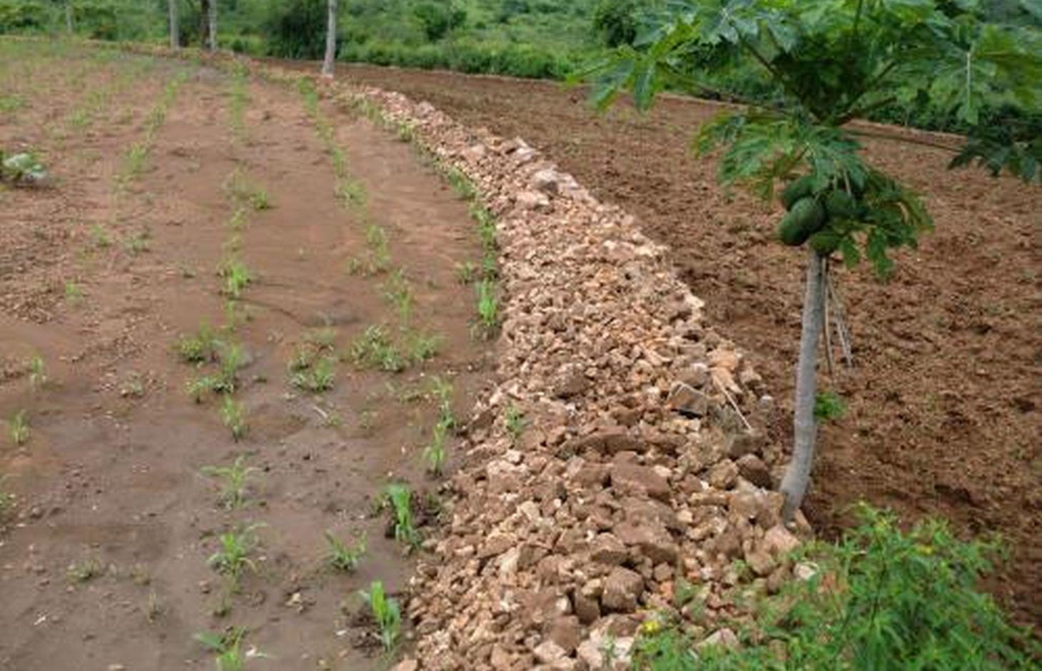
Stonelines are constructed along the contours to slow down the speed of runoff, filter the soil and enhance water infiltration.
2.2 Технологийн дэлгэрэнгүй тайлбар
Тодорхойлолт:
In Kenya stone lines are mostly practiced in areas that receive 200-750 mm of annual rainfall with a spacing of 15-30 m between them. They are particularly common in areas where rocks are readily available, such as Mbeere, Laikipia, Baringo, Mwingi, Kitui and Tharaka. Since the stonelines are permeable they do not pond runoff water but instead, they slow down the speed, filter it and spread the water over the field, thus enhancing water infiltration and reducing soil erosion. They are built in series running along the slope. In addition, the stone barrier blocks and settles down the sediments transported from the upper slopes.
Purpose of the Technology: They are often used to rehabilitate eroded and abandoned land. The advantages of stonelines include; slowing down the runoff thereby increasing infiltration and soil moisture. They also induce a natural process of terracing, reducing erosion and rehabilitation of eroded lands by trapping silt. They are easy to design and construct and since the stone line structure is permeable there is no need for construction of spillways to drain the excess runoff water. When it rains, the soil builds up on the upslope side of the stonelines and over time a natural terrace is formed.
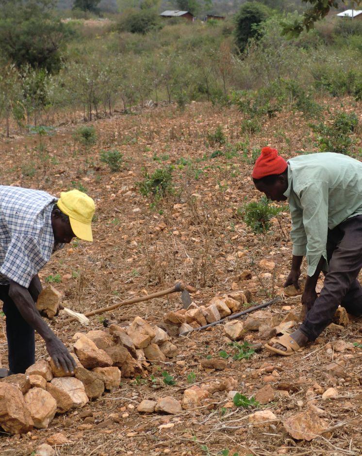
Establishment / maintenance activities and inputs: The stonelines are spaced 15-30 m apart, a shorter distance being used for the steeper slopes. Stonelines are normally suitable on gentle slopes. Slopes above 35% should be avoided. They are established in the following manner: first, the contour line are marked out with the help of a tube level or line levels. In this region here, it is done with the help of the frontline agricultural extension officers. Secondly, a shallow foundation trench is dug across the slope (5-10 cm to 30 cm deep) using basic farm equipments (jembes or hoes). As shown on the above photographs, the larger stones are put on the down slope side of the trench while the smaller stones are used to build the rest of the bund. The smallest stones are used to fill the gaps and increase the heights of the bunds up to the desired level. Farmers plant fruit trees (pawpaws) as show in the photograph above on the upper part. The trees utilises the moisture and rich sediments deposited on the upper part. The stonelines can be reinforced with earth, or crop residues to make them more stable. Maintenance of stonelines is done by repairing the already damaged /fallen stoneline that may have been knocked down or disarranged by livestock or by human beings. In this case animal access needs to be limited and/or the bund should be laid out in a way that allows the animals to pass through.
Natural / human environment: In the lower Mbeere South District where the stoneline technologies is largely practiced, unless there are stones in the individual farms, it might be difficult to import stones from other farms as the exercise can be labor intensive. In this catchment, the Ministry of Agriculture through the front line extension officers has taken a lead role in encouraging farmers to adopt the technology especially the farms which have many stones. Most of the farmers who have implemented this technology in the Lower Mbeere South District learn from the ones who are already practicing through field days or individual initiatives.
2.3 Технологийн гэрэл зураг
Медиа галерей
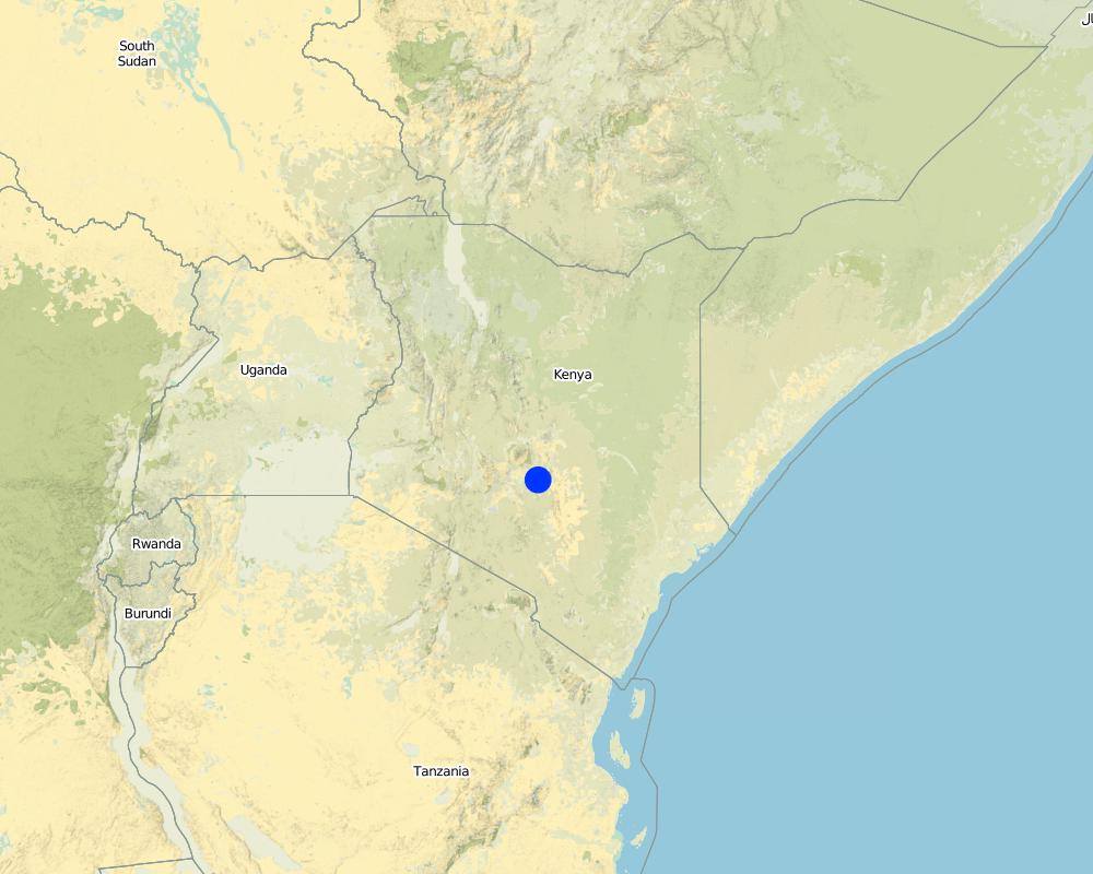
2.5 Энэ үнэлгээнд хамрагдсан технологийг хэрэгжүүлсэн улс орон / бүс нутаг / байршил
Улс :
Кени
Улс/аймаг/сум:
Eastern Province
Байршлын дэлгэрэнгүй тодорхойлолт:
Mbeere South District
Технологи өргөн дэлгэрсэн эсхийг тодорхойл:
- газар дээр жигд тархсан
Хэрэв талбайн хэмжээ тодорхойгүй бол талбайн хэмжээг ойролцоогоор тодорхойлно уу.
- < 0.1 км2 (10 га)
Тайлбар:
Not many farmers are practicing stonelines, the farmers who are practicing are copying from some successful farmers within their neighborhood. They also corroborate with the local agricultural extension officers from the Ministry of Agriculture (MoA) to show them how to construct the stonelines along the contours.
Map
×2.6 Хэрэгжих огноо
Байгуулсан тодорхой оныг мэдэхгүй бол баримжаа хугацааг тодорхойл:
- 10-50 жилийн өмнө
2.7 Технологийн танилцуулга
Технологийг хэрхэн нэвтрүүлснийг тодорхойл:
- Газар ашиглагчдын санаачилгаар
Тайлбар (төслийн төрөл г.м.):
The land had too many stones which inhibited operations. By removing the stones, the farmer placed them in line along the contour.
3. ГТМ технологийн ангилал
3.1 Технологийн үндсэн зорилго (д)
- Газрын доройтлыг бууруулах, сэргийлэх, нөхөн сэргээх
3.2 Технологи хэвтрүүлсэн газрын одоогийн газар ашиглалтын хэлбэр(д)

Тариалангийн газар
- Нэг наст үр тариа
- Олон наст (модлог биш) тариалан
- Мод, бут тариалах
Тариалан - Таримлыг тодорхойлно уу:
- үр тариа - эрдэнэ шиш
- үр тариа - шар будаа
- үр тариа - жирийн сорго
- буурцагт ургамал - вандуй
Мод, бут тариалах - Таримлыг тодорхойлно уу:
- манго, давжаа манго, гуав
- жимс (алим, лийр г.м.)
Нэг жил дэх ургамал ургах улирлын тоо:
- 2
Тодорхойлно уу:
Longest growing period in days: 90 Longest growing period from month to month: March-May Second longest growing period in days: 90 Second longest growing period from month to month: October - December
Тайлбар:
Major crop: Sorghum, maize, mangoes, pawpaws, miraa, millet, cowpeas
Major land use problems (compiler’s opinion): Limited cultivation land due to hindrances that are brought about by the scattered stones on the land's surface.
Major land use problems (land users’ perception): Soil erosion because of lack of soil and water conservation structures that leads to low land productivity.
Future (final) land use (after implementation of SLM Technology): Cropland: Ca: Annual cropping
3.3 Технологи хэрэгжүүлснээс газар ашиглалтад өөрчлөлт гарсан уу?
Технологи хэрэгжүүлснээс газар ашиглалтад өөрчлөлт гарсан уу?
- Тийм (Технологи хэрэгжүүлэхээс өмнөх үеийн газар ашиглалтын талаархи асуулгыг бөглөнө үү)
Тариалангийн газар
- Мод, бут тариалах
3.4 Усан хангамж
Технологи хэрэгжүүлсэн газрын усан хангамж:
- Байгалийн усалгаатай
3.5 Технологи ГТМ-ийн аль бүлэгт хамаарах
- урсац өөрчлөх ба урсац бүрдүүлэх
3.6 Технологийг бүрдүүлэх ГТМ арга хэмжээ

Барилга байгууламжийн арга хэмжээ
- S2: Далан, хаалт
3.7 Технологийн шийдвэрлэсэн газрын доройтлын үндсэн төрлүүд

Хөрс усаар эвдрэх
- Wt: Хөрсний гадаргын угаагдал
Тайлбар:
Main type of degradation addressed: Wt: loss of topsoil / surface erosion
Main causes of degradation: soil management, Heavy / extreme rainfall (intensity/amounts), poverty / wealth, labour availability (Construction of the technology is labour intensive)
Secondary causes of degradation: deforestation / removal of natural vegetation (incl. forest fires)
3.8 Газрын доройтлоос урьдчилан сэргийлэх, сааруулах ба нөхөн сэргээх
Газрын доройтолтой холбоотойгоор Технологи ямар зорилго тавьсан болохыг тодорхойл:
- Газрын доройтлоос урьдчилан сэргийлэх
- Хүчтэй доройтсон газрыг нөхөн сэргээх/ сайжруулах
Тайлбар:
Secondary goals: mitigation / reduction of land degradation
4. Техникийн нөхцөл, хэрэгжилтийн үйл ажиллагаа, материал ба зардал
4.1 Технологийн техникийн зураг
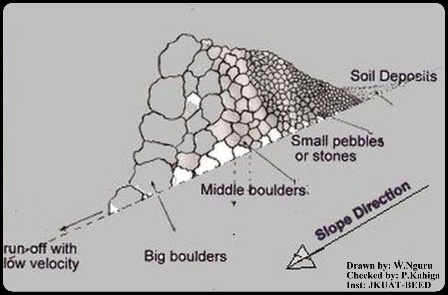
Техник тодорхойлолт (техник зурагтай уялдана):
This is a technical drawing representing a cross-section view of how the stonelines are constructed by the emerging farmers in the lower Mbeere South District.
First, a small trench is dug along an established contour line, the farmer starts arranging the stones with reference to their sizes. The bigger ones are arranged on the lower side and the small ones on the upper side as shown on the technical drawing.
By so doing, the eroded soils are trapped on the upper side by the small pebbles, allowing the water to pass through at lower speed hence low erosive capacity.
Location: Ntharawe. Lower Mbeere South District
Date: 2011-08-02
Technical knowledge required for field staff / advisors: moderate (In order to implement this technology, the farmers contact the front line agricultural extension officer in order to assist in making the contours.)
Technical knowledge required for land users: high (Stone required placement of a certain order. Big stone on the lower side and small stones on the upper side-Vertically)
Main technical functions: water spreading, sediment retention / trapping, sediment harvesting
Secondary technical functions: reduction of slope angle
Bund/ bank: graded
Spacing between structures (m): 15
Height of bunds/banks/others (m): 0.8
Width of bunds/banks/others (m): 1.2
Length of bunds/banks/others (m): 27.6
Slope (which determines the spacing indicated above): 8%
Lateral gradient along the structure: 8%
Зохиогч:
W.Nguru, P.O.Box 12776-00100 Nairobi
4.2 Материал болон зардалд хамаарах ерөнхий мэдээлэл
Үнэ өртөг, оруулсан хувь нэмрийг хэрхэн тооцсоныг тодорхойл:
- Технологийн нэгж тус бүр
Нэгжийг тодорхойл:
Stonelines
бусад/үндэсний мөнгөн нэгж (тодорхойл):
Kshs
Хэрэв боломжтой бол үндэсний валютын Америк доллартай харьцах харьцааг бичнэ үү (тухайлбал, 1 ам.дол. = 79,9 Бразил реал): 1 ам.дол. =:
80.0
Хөлсний ажилчны нэг өрдийн ажлын хөлсийг тодорхойл:
2.50
4.3 Байгуулах үйл ажиллагаа
| Үйл ажиллагаа | Хугацаа (улирал) | |
|---|---|---|
| 1. | Establish a contour line and dig up a trench upon which the stones will be arranged | yearly |
| 2. | stones are collected and arranged along the established trench. The big boulders are reduced to the required sizes by the use of mattocks | once |
| 3. | The big stones are arranged on the lower side and the rest follows with respect to their sizes on the upper side | |
| 4. | This formation is done per meter length. Mostly is charged 150Kshs per meter. |
4.4 Байгуулалтад шаардагдах зардал ба материал
| Хөрөнгө оруулалтыг дурьдана уу | Хэмжих нэгж | Тоо хэмжээ | Нэгжийн өртөг | Материал бүрийн нийт өртөг | % газар ашиглачаас гарсан зардал | |
|---|---|---|---|---|---|---|
| Хөдөлмөр эрхлэлт | Establish a contour line | Persons/day | 0.5 | 3.76 | 1.88 | 100.0 |
| Хөдөлмөр эрхлэлт | Reduce stone size | Persons/day | 0.5 | 3.76 | 1.88 | 100.0 |
| Хөдөлмөр эрхлэлт | Arranging stones | Persons/day | 0.5 | 3.76 | 1.88 | 100.0 |
| Тоног төхөөрөмж | Mattock | pieces | 1.0 | 18.75 | 18.75 | 100.0 |
| Тоног төхөөрөмж | Wheelbarrow | pieces | 1.0 | 20.0 | 20.0 | 100.0 |
| Барилгын материал | Stone | no | 1.0 | 1.88 | 1.88 | 100.0 |
| Технологи бий болгох нийт үнэ өртөг | 46.27 | |||||
| Технологи бий болгох нийт үнэ өртөг, ам.доллар | 0.58 | |||||
Тайлбар:
Duration of establishment phase: 1 month(s)
4.5 Засвар үйлчилгээ / давтагдах үйл ажиллагаа
| Үйл ажиллагаа | Хугацаа/ давтамж | |
|---|---|---|
| 1. | Repair/Rearrange stone on stone line after a rainy seasons or when people and animals have destroyed the stone line. | yearly during dry season |
4.6 Засвар үйлчилгээ / урсгал үйл ажиллагаанд шаардагдах зардал ба материал (жилээр)
| Хөрөнгө оруулалтыг дурьдана уу | Хэмжих нэгж | Тоо хэмжээ | Нэгжийн өртөг | Материал бүрийн нийт өртөг | % газар ашиглачаас гарсан зардал | |
|---|---|---|---|---|---|---|
| Хөдөлмөр эрхлэлт | Repair/Rearrange stone | mandays/acre | 14.0 | 2.5 | 35.0 | 100.0 |
| Технологийг арчилах тордоход шаардагдах нийт үнэ өртөг | 35.0 | |||||
| Технологи сайжруулах нийт үнэ өртөг, ам.доллар | 0.44 | |||||
Тайлбар:
Machinery/ tools: A wheel barrow (for carrying) and mattocks (for breaking) may be used
The cost applies for the year 2011 and was calculated per metre square, metre length, metre height and metre width.
4.7 Зардалд нөлөөлж байгаа хамгийн чухал хүчин зүйл
Өртөг зардлыг тодорхойлох гол хүчин зүйлсийг дурьдана уу:
The system is labour intensive and hence will affect the cost of constructing the stonelines. However, availability of farm equipments like wheelbarrows, mattocks or oxen will help reduce the total cost and time required for construction and maintaining the stonelines. On steep slopes, the spacing between the lines is small as compared to a relatively gentle slope.
5. Хүн, байгалийн хүрээлэн буй орчин
5.1 Уур амьсгал
Жилийн нийлбэр хур тундас
- <250 мм
- 251-500 мм
- 501-750 мм
- 751-1,000 мм
- 1,001-1,500 мм
- 1,501-2,000 мм
- 2,001-3,000 мм
- 3,001-4,000 мм
- > 4,000 мм
Хур тунадасны талаархи тодорхойлолт/ тайлбар:
Annual rainfall: Also < 250 mm
Агро-уур амьсгалын бүс
- Хагас хуурай
Thermal climate class: tropics
5.2 Байрзүйн зураг
Дундаж налуу:
- Тэгш (0-2 %)
- Бага зэрэг хэвгий (3-5 %)
- Дунд зэрэг хэвгий (6-10 % )
- Долгиорхог (11-15 %)
- Толгодорхог (16-30 %)
- Эгц налуу (31-60 % )
- Огцом эгц налуу (>60 %)
Гадаргын хэлбэр:
- Тэгш өндөрлөг/тэгш тал
- Зоо, хяр
- Уулын энгэр, хажуу
- Ухаа, гүвээ, дов толгод
- Уулын бэл
- Хөндий, хоолой, нам хотос
Өндөршлийн бүс:
- 0-100 м д.т.д
- 101-500 м д.т.д
- 501-1,000 м д.т.д
- 1,001-1,500 м д.т.д
- 1,501-2,000 м д.т.д
- 2,001-2,500 м д.т.д
- 2,501-3,000 м д.т.д
- 3,001-4,000 м д.т.д
- > 4,000 м д.т.д
5.3 Хөрс
Хөрсний дундаж зузаан:
- Маш нимгэн (0-20 см)
- Нимгэн (21-50 см)
- Дунд зэрэг зузаан (51-80 см)
- Зузаан (81-120 cм)
- Маш зузаан (>120 cм)
Хөрсний бүтэц (өнгөн хөрс):
- Сийрэг/хөнгөн (элсэрхэг)
Өнгөн хөрсний органик нэгдэл:
- Бага (<1 % )
Боломжтой бол хөрсний бүрэн тодорхойлолт, боломжит мэдээллийг өгнө үү, жишээ нь хөрсний төрөл, хөрсний урвалын орчин/хүчиллэг байдал, катион солилцох чадавхи, азотын хэмжээ, давсжилт г.м.
Soil texture: With a lot of stones
Soil fertility is medium
Soil drainage / infiltration is medium
Soil water storage capacity is medium
5.4 Усны хүртээм ба чанар
Хөрсний усны гүн:
> 50 м
Гадаргын усны хүртээмж:
Муу/огт байхгүй
Усны чанар (цэвэрлээгүй):
Сайн чанарын ундны ус
Усны чанар, нөөцийн талаархи тайлбар ба бусад тодорхойлолт:
Availability of surface water: The rivers are seasonal, water availability is from river beds if not during the rainy seasons
5.5 Биологийн төрөл зүйл
Зүйлийн олон янз байдал:
- Дунд зэрэг
5.6 Технологи нэвтрүүлсэн газар ашиглагчидын онцлог шинж
Үйлдвэрлэлийн системийн зах зээлийн чиг баримжаа:
- холимог (амьжиргаа ба худалдаанд)
Фермээс гадуурх орлого:
- Нийт орлогын %10 доош хувь
Чинээлэг байдлыг харьцангуй түвшин:
- Ядуу
Хувь хүн эсвэл бүлэг:
- Хувь хүн / өрх
Механикжилтын түвшин:
- Хүнд хүчир ажил
- Амьтны зүтгүүр
Хүйс:
- Эрэгтэй
Газар ашиглагчдын бусад шаардлагатай шинж чанарыг тодорхойл:
Land users applying the Technology are mainly common / average land users
Population density: 10-50 persons/km2
Annual population growth: < 0.5%
80% of the land users are poor.
5.7 Технологи нэвтрүүлэхэд газар ашиглагчийн ашигласан газрын дундаж талбай
- < 0.5 га
- 0.5-1 га
- 1-2 га
- 2-5 га
- 5-15 га
- 15-50 га
- 50-100 га
- 100-500 га
- 500-1,000 га
- 1,000-10,000 га
- > 10,000 га
Энэ нь жижиг, дунд, том оворт тооцогдох уу (орон нутгийн чиг баримжаагаар)?
- Бага-хэмжээний
5.8 Газар эзэмшил, газар ашиглах эрх, ус ашиглах эрх
Газар өмчлөл:
- Хувь хүн, цол эргэм бүхий
5.9 Дэд бүтэц, үйлчилгээний хүртээмж
эрүүл мэнд:
- Ядуу
- Дунд зэргийн
- Сайн
боловсрол:
- Ядуу
- Дунд зэргийн
- Сайн
техник дэмжлэг:
- Ядуу
- Дунд зэргийн
- Сайн
хөдөлмөр эрхлэлт (жишээ нь, ХАА-аас өөр):
- Ядуу
- Дунд зэргийн
- Сайн
зах зээл:
- Ядуу
- Дунд зэргийн
- Сайн
эрчим хүч:
- Ядуу
- Дунд зэргийн
- Сайн
зам ба тээвэр:
- Ядуу
- Дунд зэргийн
- Сайн
ундны ус ба ариутгал:
- Ядуу
- Дунд зэргийн
- Сайн
санхүүгийн үйлчилгээ:
- Ядуу
- Дунд зэргийн
- Сайн
6. Үр нөлөө ба дүгнэлт
6.1 Технологийн талбай дахь үр нөлөө
Нийгэм-эдийн засгийн үр нөлөө
Үйлдвэрлэл
Газар тариалангийн үйлдвэрлэл
үйлдвэрлэл зогсох эрсдэл
Үйлдвэрлэлийн газар
газрын менежмент
Тайлбар/ тодорхой дурьдах:
Such that it hinders mechanisation tractors cannot operate due to the stone line arragement
Орлого, зарлага
хөдөлмөр хүчний хэмжээ
Тайлбар/ тодорхой дурьдах:
The operation is labour intensive
Бусад нийгэм-эдийн засгийн нөлөөллүүд
Livelihood and human well-being
Тайлбар/ тодорхой дурьдах:
Increased food security (the yield near the stoneline is better as compared to the situation that it was before implementation).
Нийгэм-соёлын үр нөлөө
ГТМ/ газрын доройтлын талаархи мэдлэг
Нийгэм, эдийн засгийн хувьд эмзэг бүлгийнхний нөхцөл байдал
Экологийн үр нөлөө
Хөрс
хөрсний чийг
хөрс алдагдах
Биологийн: ургамал, амьтан
хортон шавж/өвчний хяналт
Тайлбар/ тодорхой дурьдах:
Snakes and scorpions
Уур амьсгал болон гамшгийн эрсдлийг бууруулах
үер усны нөлөө
6.2 Технологийн талбайн гадна үзүүлсэн үр нөлөө
Доод урсгалын үер
буферлэх / шүүлтүүрийн багтаамж
6.3 Технологийн уур амьсгалын өөрчлөлт ба Уур амьсгалаас хамаарах аюул/гамшигт үзэгдэлд өртөх байдал ба эмзэг байдал (газар ашиглагч нарын дүгнэлтээр)
Уур амьсгалын аажим өөрчлөлт
Уур амьсгалын аажим өөрчлөлт
| Улирал | Өсөх эсвэл буурах | Технологи түүний нөлөөг хэрхэн бууруулж байна? | |
|---|---|---|---|
| Жилийн дундаж температур | Өсөлт | Сайн |
Уур амьсгалаас хамаарах аюулууд (гамшигууд)
Цаг уурын гамшигууд
| Технологи түүний нөлөөг хэрхэн бууруулж байна? | |
|---|---|
| Орон нутгийн аадар бороо | Сайн биш |
| Орон нутгийн салхин шуурга | Сайн |
Уур амьсгалын гамшигууд
| Технологи түүний нөлөөг хэрхэн бууруулж байна? | |
|---|---|
| Ган гачиг | Сайн |
Гидрологийн гамшиг
| Технологи түүний нөлөөг хэрхэн бууруулж байна? | |
|---|---|
| усны үер (гол) | Сайн биш |
6.4 Зардал ба үр ашгийн шинжилгээ
Үр ашгийг барилга байгууламжийн зардалтай (газар ашиглагчдын үзэл бодлоор) хэрхэн харьцуулах вэ?
Богино хугацаанд эргэн төлөгдөх байдал:
Бага зэрэг эерэг
Урт хугацаанд эргэн төлөгдөх байдал:
Эерэг
Үр ашгийг засвар үйлчилгээ/ урсгал зардалтай (газар ашиглагчдын үзэл бодлоор) хэрхэн харьцуулах вэ?
Богино хугацаанд эргэн төлөгдөх байдал:
Эерэг
Урт хугацаанд эргэн төлөгдөх байдал:
Эерэг
6.5 Технологи нутагшуулах
Тайлбар:
There is a moderate trend towards spontaneous adoption of the Technology
Comments on adoption trend: The technology is mainly practiced on the farms with stones even though the farmers admit that the task of construction is labour intensive. However, these not withstanding, the farmers do acknowledge that the technology is beneficial since they can see the results of yields from the ones who are already practicing.
6.7 Технологийн давуу тал/боломжууд
| Газар ашиглагчдын тодорхойлсон давуу тал/боломжууд |
|---|
|
By concentrating the stones along a contour, the farmer is able to make use of the land which otherwise is not possible if the stones are scatered. How can they be sustained / enhanced? Farmers should be encouraged to learn from one another but they should also seek advice from extension officers in making the contours. |
| The cost of replacement of farm equipments (jembes, forks and pangas) is reduced since they aren't broken by stones during land preparation. |
| Эмхэтгэгч, бусад мэдээлэл өгсөн хүмүүсийн өнцгөөс тодорхойлсон давуу тал/боломжууд |
|---|
|
The stones for constructing the technology are readily available in most of the farms. How can they be sustained / enhanced? Encouraging farmers to use the available stones to put up the technology. |
|
Stoneline technology prevents soil loss due to erosion. How can they be sustained / enhanced? Modification of the technology to allow more infiltration. |
|
No high level technical knowledge is required for construction of stoneline technology. How can they be sustained / enhanced? More farmers should be encouraged to adopt the technology since they dont need a high level of technical knowledge. |
|
Stone lines technology can be modified to prevent soil and water from running off on the side of stone line ridge. How can they be sustained / enhanced? Construction of side ridges. |
6.8 Технологийн дутагдалтай/сул тал/аюул болон тэдгээрийн хэрхэн даван туулах арга замууд
| Газар ашиглагч нарын тодорхойлсон сул тал/ дутагдал/ эрсдэл | Тэдгээрийг хэрхэн даван туулах вэ? |
|---|---|
| Contour profiling is challenging. | Assistance from the front line agricultural extension officers. |
| Эмхэтгэгч, бусад мэдээлэл өгсөн хүмүүсийн өнцгөөс тодорхойлсон сул тал/ дутагдал/ эрсдэл | Тэдгээрийг хэрхэн даван туулах вэ? |
|---|---|
| Labour intensive. | When constructing, always move the stones downslope by gravity instead of moving upwards i.e. start from the contours from the upper side |
| The technology only allows the soil to deposit on the upper side of the stoneline but water passes through. | Proper arrangement of the stones should be enhanced basing on their sizes. |
| Increased habitats for snakes and other dangerous creatures like scorpions that hide on the stonelines. | Where there creatures are prone, the farmers should be careful. |
7. Ном зүй ба холбоосууд
7.1 Мэдээллийн аргууд / эх сурвалжууд
7.2 Хүртээмжтэй ном, бүтээлийн ишлэл
Гарчиг, зохиогч, он, ISBN:
Thomas, D.B. (eds) 1997. Soil and Water Conservation Manual for Kenya. Soil and Water Conservation Branch. Ministry of Agriculture, Livestock Development and Marketing. 210 p.
Гарчиг, зохиогч, он, ISBN:
Critchley W and Seigert K (1991) Water Harvesting. FAO
Холбоос ба модулууд
Бүгдийг харуулах Бүгдийг хаахХолбоосууд
Холбоос байхгүй байна
Модулууд
Модуль байхгүй байна