Contour stone bunds [Нигер ]
- Шинийг нээх:
- Шинэчлэх:
- Мэдээлэл цуглуулсан: Dieter Nill
- Редактор: –
- Хянагчид: David Streiff, Alexandra Gavilano
Cordons pierreux (French)
technologies_1616 - Нигер
Бүлгүүдийг үзэх
Бүгдийг харуулах Бүгдийг хаах1. Ерөнхий мэдээлэл
1.2 Технологийг үнэлэх, баримтжуулах ажилд хамаарах мэдээлэл өгсөн хүмүүс, байгууллагуудын холбоо барих мэдээлэл
ГТМ мэргэжилтэн :
Dorlöchter-Sulser Sabine
Misereor
Герман
ГТМ мэргэжилтэн :
Mamadou Abdou Gaoh Sani
Programme d’Appui à l’agriculture Productive
Нигер
Технологи баримтжуулах/үнэлэх ажилд дэмжлэг үзүүлсэн төслийн нэр (шаардлагатай бол)
Programme d’Appui à l’agriculture Productive (GIZ / PROMAP)Технологи баримтжуулах/үнэлэх ажилд дэмжлэг үзүүлсэн төслийн нэр (шаардлагатай бол)
Manual of Good Practices in Small Scale Irrigation in the Sahel (GIZ )Технологи баримтжуулах/үнэлэх ажилд дэмжлэг үзүүлсэн байгууллага(ууд)-ын нэр (шаардлагатай бол)
Deutsche Gesellschaft für Internationale Zusammenarbeit (GIZ) - ГерманТехнологи баримтжуулах/үнэлэх ажилд дэмжлэг үзүүлсэн байгууллага(ууд)-ын нэр (шаардлагатай бол)
Misereor - Герман1.3 WOCAT-аар баримтжуулсан өгөгдлийг ашиглахтай холбоотой нөхцөл
Эмхэтгэгч болон гол мэдээлэгч хүн(хүмүүс) WOCAT аргачлалаар баримтжуулсан мэдээллийг ашиглахтай холбоотой нөхцлийг хүлээн зөвшөөрсөн.
Тийм
2. ГТМ Технологийн тодорхойлолт
2.1 Технологийн товч тодорхойлолт
Технологийн тодорхойлолт:
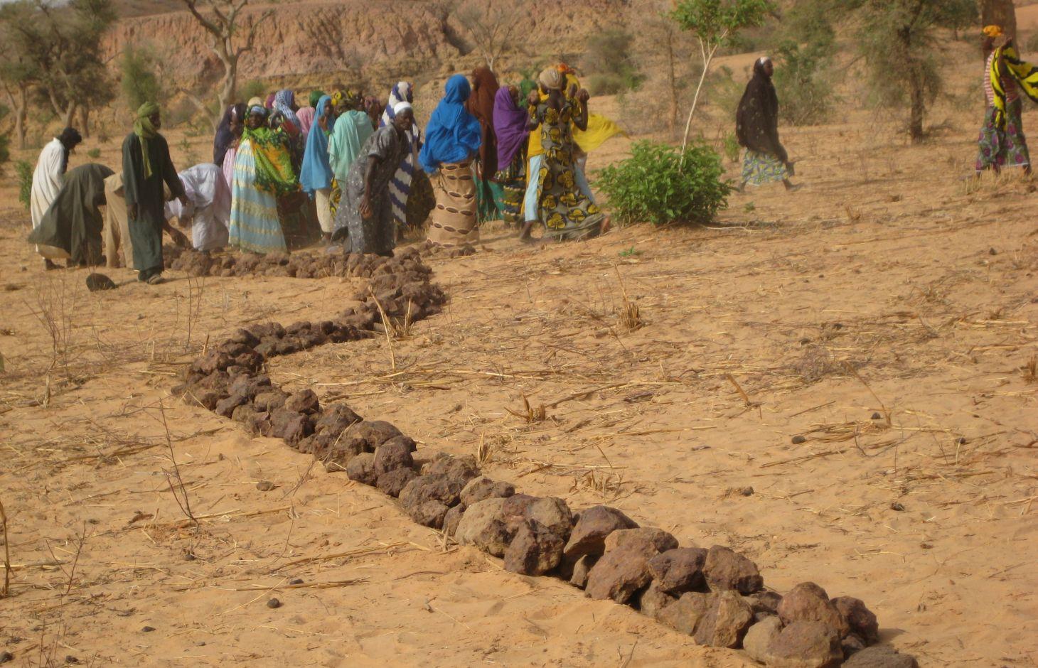
Contour stone bunds are erosion control structures and improve water retention and infiltration into the soil, resulting in an increased harvest.
2.2 Технологийн дэлгэрэнгүй тайлбар
Тодорхойлолт:
Contour stone bunds are erosion control structures built with quarry rock or stones in series of two or three. They are constructed in lines along the natural contour of the land after 10-15 cm of the soil has been removed from the line where they are to be built. They should be built to a height of 20-30 cm from the ground and spaced 20 to 50 m apart depending on the inclination of the terrain.
The best results are achieved when contour stone bunds are used in combination with biological measures (planting of grass, trees and hedges) and the use of organic fertiliser and mulching.
Purpose of the Technology: Contour stone bunds protect the land against sheet erosion caused by runoff. They form a barrier that slows down runoff and spreads it more evenly over the land. By slowing the flow of water over the land, it can seep into the soil and prevents the loss of rainwater. The bunds also act as a filter, trapping fine waterborne particles of soil and manure, resulting in a build-up of sediment and the formation of terraces. The seeds of grasses and shrubs are also trapped by the bunds, favouring the establishment of natural vegetation along the structure. This further stabilises the soil and the bunds and contributes to conserving the biodiversity of plants and small wild animals (monitor lizards, birds, snakes and other reptiles). If good vegetation cover is developed on the stone bunds, they also lower soil temperature and provide protection against wind erosion. Excess water filters through the bunds and infiltrates into the soil. When rainfall is erratic, the stone bunds contribute to conserving more moisture in the soil for longer, which helps to alleviate water stress during dry spells. There is evidence that bunds that have been in place for over 15 years have positive effects on yields.
Establishment / maintenance activities and inputs: A minimum amount of upkeep is required, which essentially involves replacing stones dislodged by animals or water flow. The lifespan of a stone bund is over 20 years.
In order to optimise the positive effects of stone bunds, it is important to ensure that they are constructed closely following the natural contour of the land and in accordance with the established technical standards.
The means of transport required depends on the proximity of a quarry or a supply of stones (cart or lorry).
Natural / human environment: This technique is designed for cropland, but can also be used on forest/rangeland. It is suitable for areas in the Sahel and the Sudan with rainfall ranging between 300 and 900 mm/year and low-to-medium gradient terrain.
When rainfall is high, they protect the land in the event of heavy rain, a phenomenon that tends to increase with climate change.
2.3 Технологийн гэрэл зураг
Медиа галерей
2.5 Энэ үнэлгээнд хамрагдсан технологийг хэрэгжүүлсэн улс орон / бүс нутаг / байршил
Улс :
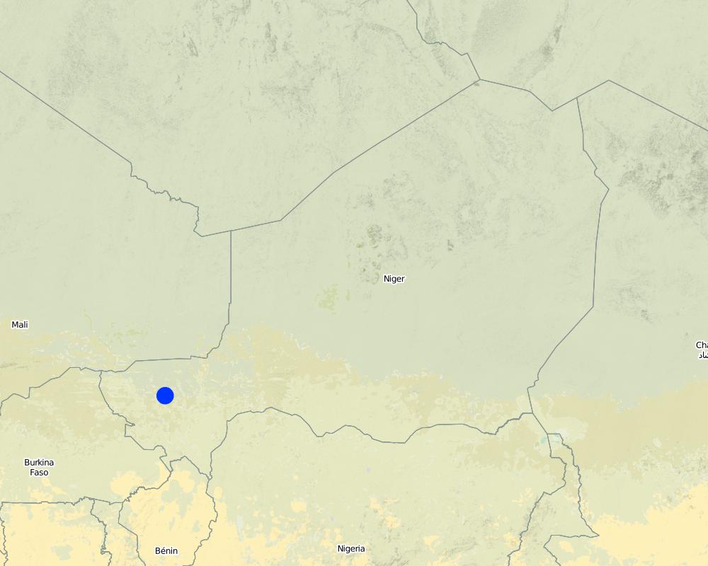
Нигер
Улс/аймаг/сум:
Niger, Mali, Burkina Faso, Chad
Байршлын дэлгэрэнгүй тодорхойлолт:
Regions of Tillabéri, Filingué, Ouallam, Téra and Tahuoa
Технологи өргөн дэлгэрсэн эсхийг тодорхойл:
- газар дээр жигд тархсан
Хэрэв талбайн хэмжээ тодорхойгүй бол талбайн хэмжээг ойролцоогоор тодорхойлно уу.
- > 10,000 км2
Тайлбар:
Large-scale areas have been protected in most Sahel countries. German Development Cooperation (BMZ/GIZ/KfW) for example has had several projects in Chad, Burkina Faso, Niger, Mali, Benin, which have applied stone bunds on around 800.000 to 1.000.000 ha since the 90ies.
Map
×2.6 Хэрэгжих огноо
Байгуулсан тодорхой оныг мэдэхгүй бол баримжаа хугацааг тодорхойл:
- 10-50 жилийн өмнө
2.7 Технологийн танилцуулга
Технологийг хэрхэн нэвтрүүлснийг тодорхойл:
- Гадны төсөл/хөтөлбөрийн дэмжлэгтэйгээр
Тайлбар (төслийн төрөл г.м.):
Known as traditional method in some areas. Improved and up-scaled as part of numerous projects in many semi-arid countries. German Developmenmt Cooperation has used the technology from the 1980s onwards to combat desertification and improve natural resource management e.g. PDRT (Projet de développement rural de Tahoua - Tahoua Rural Development Project), PASP (Projet de protection intégrée des ressources agro-sylvo-pastorales Tillabéri-Nord - Project for the Integrated Protection of Agricultural, Forest and Rangeland Resources in Tillabéri-Nord) and several other projects of GIZ/KfW and other donors.
3. ГТМ технологийн ангилал
3.1 Технологийн үндсэн зорилго (д)
- Газрын доройтлыг бууруулах, сэргийлэх, нөхөн сэргээх
3.2 Технологи хэвтрүүлсэн газрын одоогийн газар ашиглалтын хэлбэр(д)
Нэг газр нутгийн хэмжээнд хэрэгжих холимог газар ашиглалт:
Тийм
Газар ашиглалтын холимог тогтолцоог (тарилан/бэлчээр/ой мод) тодорхойл:
- Агро-сильво-пасторализм

Тариалангийн газар
- Нэг наст үр тариа
- Мод, бут тариалах
Тариалан - Таримлыг тодорхойлно уу:
- тосны ургамал - газрын самар
- үр тариа - шар будаа
- үр тариа - жирийн сорго
- буурцагт ургамал - вандуй
Мод, бут тариалах - Таримлыг тодорхойлно уу:
- манго, давжаа манго, гуав
Нэг жил дэх ургамал ургах улирлын тоо:
- 1
Тодорхойлно уу:
Longest growing period in days: 120; Longest growing period from month to month: August to October

Бэлчээрийн газар
Нүүдлийн бэлчээр ашиглалт:
- Нүүдэлчин
- Хагас нүүдлийн бэлчээрийн аж ахуй
Эрчимжсэн бэлчээр / тэжээл үйлдвэрлэл:
- Хадлан буюу бэлчээрт ашиглагдахгүй талбай
- Сайжруулсан бэлчээр

Байгалийн ой / модтой газар
- (Сайжруулсан) байгалийн ой/мод бүхий газар
(Хагас)байгалийн ой/тармаг ойд: Менежментийн төрлийг тодорхойлно уу:
- Сонголттой огтлол
Бүтээгдэхүүн ба үйлчилгээ:
- Мод бэлтгэл
- Түлшний мод
- Жимс, самар
- Бусал ойн дагалт бүтээгдэхүүн
- Бэлчээрийн талбай/Хариулгатай бэлчээрлэлт
Тайлбар:
major cash crop: Ground nut
major food crop: Millet
other: Sorghum, cow pea and mangoes
Major land use problems (compiler’s opinion): surface runoff, erosion by water and wind, fertility decline,
Nomadism: Yes
Semi-nomadism / pastoralism: Yes
Cut-and-carry/ zero grazing: Yes
Improved pasture: Yes
Other grazingland: agropastoralism
Selective felling of (semi-) natural forests: Yes
Forest products and services: timber, fuelwood, fruits and nuts, grazing / browsing, other forest products / uses (honey, medical, etc.)
Type of cropping system and major crops comments: farmers are mainly agropastoralists with some communities specialised on pure pastoralism
Constraints of common grazing land
Constraints of forested government-owned land or commons
Livestock density: 1-10 LU /km2
3.4 Усан хангамж
Технологи хэрэгжүүлсэн газрын усан хангамж:
- Байгалийн усалгаатай
Тайлбар:
Water supply: Also mixed rainfed - irrigated and post-flooding
3.5 Технологи ГТМ-ийн аль бүлэгт хамаарах
- Налуугийн хөндөлн огтлолын дагуух арга хэмжээ
3.6 Технологийг бүрдүүлэх ГТМ арга хэмжээ

Барилга байгууламжийн арга хэмжээ
- S2: Далан, хаалт
3.7 Технологийн шийдвэрлэсэн газрын доройтлын үндсэн төрлүүд

Хөрс усаар эвдрэх
- Wt: Хөрсний гадаргын угаагдал
- Wg: Гуу жалгын элэгдэл
- Wo: Усны элэгдлийн дам нөлөө

Хөрс салхиар эвдрэх
- Et: Хөрсний гадаргын зөөгдөл

Хөрсний химийн доройтол
- Cn: Үржил шим болон органик агууламж буурах (элэгдлийн шалтгаангүй)

Биологийн доройтол
- Bc: Ургамлан нөмрөг багасах

Усны доройтол
- Hs: Гадаргын усны хэмжээ багасах
Тайлбар:
Secondary types of degradation addressed: Et: loss of topsoil
Main causes of degradation: soil management (Unadapted landuse methods, reduced or abandoned fallow periods), crop management (annual, perennial, tree/shrub) (Neglect of fallow periods and crop rotation), droughts (due to heat waves and unreliable rainfall), population pressure (rapidly growing population increasing pressure on land), land tenure (insecure access to land and collectively managed communal land), poverty / wealth (very poor population)
Secondary causes of degradation: deforestation / removal of natural vegetation (incl. forest fires) (deforestation through overgrazing and fire wood collection), over-exploitation of vegetation for domestic use (firewood collection), overgrazing (cattle, sheep and goats), change in temperature (Climate change: heat waves), change of seasonal rainfall (more variable onset of rain), Heavy / extreme rainfall (intensity/amounts) (more variable and intensive rains), wind storms / dust storms (frequent storms), floods (due to intensive rain storms), labour availability (some migration of men to nearby cities), education, access to knowledge and support services (high level of illiteracy)
3.8 Газрын доройтлоос урьдчилан сэргийлэх, сааруулах ба нөхөн сэргээх
Газрын доройтолтой холбоотойгоор Технологи ямар зорилго тавьсан болохыг тодорхойл:
- Хүчтэй доройтсон газрыг нөхөн сэргээх/ сайжруулах
Тайлбар:
Secondary goals: prevention of land degradation, mitigation / reduction of land degradation
4. Техникийн нөхцөл, хэрэгжилтийн үйл ажиллагаа, материал ба зардал
4.1 Технологийн техникийн зураг
Техник тодорхойлолт (техник зурагтай уялдана):
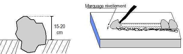
Contour stone bunds are built with quarry rock or stones in series of two or three. They are constructed in lines along the natural contour of the land after 10-15 cm of the soil has been removed from the line where they are to be built. They should be built to a height of 20-30 cm from the ground and spaced 20 to 50 m apart. The best results are achieved when contour stone bunds are used in combination with biological measures (planting of grass, trees and hedges) and the use of organic fertiliser and mulching.
Technical knowledge required for field staff / advisors: moderate
Technical knowledge required for land users: low
Main technical functions: control of dispersed runoff: retain / trap, control of dispersed runoff: impede / retard, control of concentrated runoff: retain / trap, control of concentrated runoff: impede / retard, stabilisation of soil (eg by tree roots against land slides), increase of infiltration, increase / maintain water stored in soil, water harvesting / increase water supply
Secondary technical functions: reduction of slope angle, improvement of ground cover, increase in nutrient availability (supply, recycling,…), increase of groundwater level / recharge of groundwater, sediment retention / trapping, sediment harvesting, reduction in wind speed, increase of biomass (quantity)
Bund/ bank: graded
Spacing between structures (m): 20-50
Height of bunds/banks/others (m): 0.2-0.3
Length of bunds/banks/others (m): 0.2
Material: Stone
Зохиогч:
PASP, GIZ
4.2 Материал болон зардалд хамаарах ерөнхий мэдээлэл
Үнэ өртөгийг тооцоход ашигласан мөнгөн нэгж:
- Ам.доллар
4.3 Байгуулах үйл ажиллагаа
| Үйл ажиллагаа | Хугацаа (улирал) | |
|---|---|---|
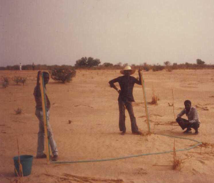
| 1. | Levelling and marking out the contour lines | |
| 2. | collecting stones and loading them onto carts | |
| 3. | transporting the stones by cart | |
| 4. | constructing the bunds | |
| 5. | applying manure |
4.4 Байгуулалтад шаардагдах зардал ба материал
| Хөрөнгө оруулалтыг дурьдана уу | Хэмжих нэгж | Тоо хэмжээ | Нэгжийн өртөг | Материал бүрийн нийт өртөг | % газар ашиглачаас гарсан зардал | |
|---|---|---|---|---|---|---|
| Хөдөлмөр эрхлэлт | Levelling and construction of bunds | ha | 1.0 | 19.32 | 19.32 | |
| Тоног төхөөрөмж | Tools | ha | 1.0 | 1.95 | 1.95 | |
| Бусад | Transport of stones | ha | 1.0 | 15.07 | 15.07 | |
| Технологи бий болгох нийт үнэ өртөг | 36.34 | |||||
| Технологи бий болгох нийт үнэ өртөг, ам.доллар | 36.34 | |||||
4.5 Засвар үйлчилгээ / давтагдах үйл ажиллагаа
| Үйл ажиллагаа | Хугацаа/ давтамж | |
|---|---|---|
| 1. | Replacing stones dislodged by animals or water flow |
4.7 Зардалд нөлөөлж байгаа хамгийн чухал хүчин зүйл
Өртөг зардлыг тодорхойлох гол хүчин зүйлсийг дурьдана уу:
The exact cost per hectare of constructing stone bunds depends on the distance of the site from the quarry, the size of the quarry, the inclination of the terrain, which determines the spacing between the stone bunds, and the actual amount of stones transported in each lorryload. The prices below are provided as a guide.
Supply of quarry rock/stones: 24 m3 per 400 m of bund
Labour: 30 man-days per ha
• levelling and marking out the contour lines: 1 man-day
• collecting stones and loading them onto carts:
10 man-days
• transporting the stones by cart: 10 man-days
• constructing the bunds: 9 man-days
• applying manure.
Transportation by cart:
• 20 cartloads of stones
• 20 cartloads of manure (if used).
Transportation by lorry:
• 6 lorryloads (skip loader – 4.5 m3 per load).
Other costs: equipment (pickaxes, shovels, wheelbarrows, water-tube level, etc.).
5. Хүн, байгалийн хүрээлэн буй орчин
5.1 Уур амьсгал
Жилийн нийлбэр хур тундас
- <250 мм
- 251-500 мм
- 501-750 мм
- 751-1,000 мм
- 1,001-1,500 мм
- 1,501-2,000 мм
- 2,001-3,000 мм
- 3,001-4,000 мм
- > 4,000 мм
Агро-уур амьсгалын бүс
- Хагас хуурай
Thermal climate class: subtropics
5.2 Байрзүйн зураг
Дундаж налуу:
- Тэгш (0-2 %)
- Бага зэрэг хэвгий (3-5 %)
- Дунд зэрэг хэвгий (6-10 % )
- Долгиорхог (11-15 %)
- Толгодорхог (16-30 %)
- Эгц налуу (31-60 % )
- Огцом эгц налуу (>60 %)
Гадаргын хэлбэр:
- Тэгш өндөрлөг/тэгш тал
- Зоо, хяр
- Уулын энгэр, хажуу
- Ухаа, гүвээ, дов толгод
- Уулын бэл
- Хөндий, хоолой, нам хотос
Өндөршлийн бүс:
- 0-100 м д.т.д
- 101-500 м д.т.д
- 501-1,000 м д.т.д
- 1,001-1,500 м д.т.д
- 1,501-2,000 м д.т.д
- 2,001-2,500 м д.т.д
- 2,501-3,000 м д.т.д
- 3,001-4,000 м д.т.д
- > 4,000 м д.т.д
Гадаргын талаархи тайлбар ба бусад тодорхойлолт:
Landforms: Also footslopes and valley floors
Altitudinal zone: 200 m a.s.l.
5.3 Хөрс
Хөрсний дундаж зузаан:
- Маш нимгэн (0-20 см)
- Нимгэн (21-50 см)
- Дунд зэрэг зузаан (51-80 см)
- Зузаан (81-120 cм)
- Маш зузаан (>120 cм)
Хөрсний бүтэц (өнгөн хөрс):
- Дунд зэрэг (шавранцар)
- Хүнд (шаварлаг)
Өнгөн хөрсний органик нэгдэл:
- Бага (<1 % )
Боломжтой бол хөрсний бүрэн тодорхойлолт, боломжит мэдээллийг өгнө үү, жишээ нь хөрсний төрөл, хөрсний урвалын орчин/хүчиллэг байдал, катион солилцох чадавхи, азотын хэмжээ, давсжилт г.м.
Soil texture (topsoil): Fine to medium (sandy to clayey loams)
5.4 Усны хүртээм ба чанар
Хөрсний усны гүн:
5-50 м
Гадаргын усны хүртээмж:
Дунд зэрэг
Усны чанар (цэвэрлээгүй):
Зөвхөн газар тариалангийн зориулалтаар ашиглах (усалгаа)
Усны чанар, нөөцийн талаархи тайлбар ба бусад тодорхойлолт:
Ground water table: > 10 m
Availability of surface water: Surface runoff generated by limited but intense rainfalls
5.5 Биологийн төрөл зүйл
Зүйлийн олон янз байдал:
- Бага
5.6 Технологи нэвтрүүлсэн газар ашиглагчидын онцлог шинж
Үйлдвэрлэлийн системийн зах зээлийн чиг баримжаа:
- Амь зуух арга хэлбэрийн (өөрийгөө хангах)
- холимог (амьжиргаа ба худалдаанд)
Фермээс гадуурх орлого:
- Нийт орлогын % 10-50 хувь
Чинээлэг байдлыг харьцангуй түвшин:
- Нэн ядуу
- Ядуу
Механикжилтын түвшин:
- Хүнд хүчир ажил
- Амьтны зүтгүүр
Хүйс:
- Эрэгтэй
Газар ашиглагчдын бусад шаардлагатай шинж чанарыг тодорхойл:
Population density: 10-50 persons/km2
Annual population growth: 3% - 4%
(mostly poor households below poverty line).
Off-farm income specification: men migrate temporarily or permanently to cities for off-farm income, women and men seasonally carry out paid farm work
Market orientation of production system: Most households crop for subsistence (mainly for small agropastoralists) and surplus is sold on market (medium agropastoralists). Commercial markets: some vegetable growing and pastoralists.
Level of mechanization: Ox and donkey used for animal traction
5.7 Технологи нэвтрүүлэхэд газар ашиглагчийн ашигласан газрын дундаж талбай
- < 0.5 га
- 0.5-1 га
- 1-2 га
- 2-5 га
- 5-15 га
- 15-50 га
- 50-100 га
- 100-500 га
- 500-1,000 га
- 1,000-10,000 га
- > 10,000 га
Энэ нь жижиг, дунд, том оворт тооцогдох уу (орон нутгийн чиг баримжаагаар)?
- Бага-хэмжээний
Тайлбар:
Average area of land owned or leased by land users applying the Technology: Also 1-2 ha
5.8 Газар эзэмшил, газар ашиглах эрх, ус ашиглах эрх
Газар өмчлөл:
- Төр засаг
- Нэгдэл/ тосгон
Газар ашиглах эрх:
- Нэгдлийн хэлбэрээр (зохион байгуулалттай)
- Хувь хүн
Тайлбар:
traditional land use rights prevail. On fields individual land use rights, communal rights on pasture and forest land (collection of wood and other products (fruits, medicinal plants))
Land ownership: Also individual not titled
5.9 Дэд бүтэц, үйлчилгээний хүртээмж
эрүүл мэнд:
- Ядуу
- Дунд зэргийн
- Сайн
боловсрол:
- Ядуу
- Дунд зэргийн
- Сайн
техник дэмжлэг:
- Ядуу
- Дунд зэргийн
- Сайн
хөдөлмөр эрхлэлт (жишээ нь, ХАА-аас өөр):
- Ядуу
- Дунд зэргийн
- Сайн
зах зээл:
- Ядуу
- Дунд зэргийн
- Сайн
эрчим хүч:
- Ядуу
- Дунд зэргийн
- Сайн
зам ба тээвэр:
- Ядуу
- Дунд зэргийн
- Сайн
ундны ус ба ариутгал:
- Ядуу
- Дунд зэргийн
- Сайн
санхүүгийн үйлчилгээ:
- Ядуу
- Дунд зэргийн
- Сайн
6. Үр нөлөө ба дүгнэлт
6.1 Технологийн талбай дахь үр нөлөө
Нийгэм-эдийн засгийн үр нөлөө
Үйлдвэрлэл
Газар тариалангийн үйлдвэрлэл
тэжээл үйлдвэрлэл
үйлдвэрлэл зогсох эрсдэл
Усны хүртээм ба чанар
усалгааны усны хэрэгцээ
Орлого, зарлага
ХАА-н хөрөнгө оруулалтын зардал
тариалангийн газрын орлого
Нийгэм-соёлын үр нөлөө
хүнсний аюулгүй байдал/ өөрийгөө хангах
ГТМ/ газрын доройтлын талаархи мэдлэг
livelihood and human well-being
Тайлбар/ тодорхой дурьдах:
There is evidence that 15 year old bunds still maintain their positive effects on yields. 40 % higher grain yields were measured on such bunds and there is no evidence to suggest that yields decline with time. In dry years, while unimproved land produces nothing, land protected by stone bunds can still produce a harvest. Higher crop production improves household food security in proportion to the area of a farm improved with bunds. Under the PASP in Niger, an average of 16% of the area of a farm was improved with stone bunds, resulting in an increase of between 8% and 33% in annual output with no other additional measures.
Экологийн үр нөлөө
Усны эргэлт/ илүүдэл
ус хураах / цуглуулах
гадаргын урсац
Хөрс
хөрсний чийг
хөрсөн бүрхэвч
хөрс алдагдах
шимт бодисын эргэлт/ сэргэлт
Биологийн: ургамал, амьтан
ургамлын төрөл, зүйл
Уур амьсгал болон гамшгийн эрсдлийг бууруулах
салхины хурд
Бусад экологийн үр нөлөө
hazard towards adverse events
6.2 Технологийн талбайн гадна үзүүлсэн үр нөлөө
урсацын адагт лаг шавар хуримтлагдана
салхиар тээвэрлэгдэх хурдас
хөрш зэргэлдээ газарт учирах хохирол
6.3 Технологийн уур амьсгалын өөрчлөлт ба Уур амьсгалаас хамаарах аюул/гамшигт үзэгдэлд өртөх байдал ба эмзэг байдал (газар ашиглагч нарын дүгнэлтээр)
Уур амьсгалын аажим өөрчлөлт
Уур амьсгалын аажим өөрчлөлт
| Улирал | Өсөх эсвэл буурах | Технологи түүний нөлөөг хэрхэн бууруулж байна? | |
|---|---|---|---|
| Жилийн дундаж температур | Өсөлт | Сайн |
Уур амьсгалаас хамаарах аюулууд (гамшигууд)
Цаг уурын гамшигууд
| Технологи түүний нөлөөг хэрхэн бууруулж байна? | |
|---|---|
| Орон нутгийн аадар бороо | Сайн биш |
| Орон нутгийн салхин шуурга | Сайн |
Уур амьсгалын гамшигууд
| Технологи түүний нөлөөг хэрхэн бууруулж байна? | |
|---|---|
| Ган гачиг | Сайн |
Гидрологийн гамшиг
| Технологи түүний нөлөөг хэрхэн бууруулж байна? | |
|---|---|
| усны үер (гол) | Сайн биш |
Бусад уур амьсгалд хамаарах үр дагаварууд
Бусад уур амьсгалд хамаарах үр дагаварууд
| Технологи түүний нөлөөг хэрхэн бууруулж байна? | |
|---|---|
| Ургалтын хугацаа багасах | Мэдэхгүй |
6.4 Зардал ба үр ашгийн шинжилгээ
Үр ашгийг барилга байгууламжийн зардалтай (газар ашиглагчдын үзэл бодлоор) хэрхэн харьцуулах вэ?
Богино хугацаанд эргэн төлөгдөх байдал:
Эерэг
Урт хугацаанд эргэн төлөгдөх байдал:
Маш эерэг
Үр ашгийг засвар үйлчилгээ/ урсгал зардалтай (газар ашиглагчдын үзэл бодлоор) хэрхэн харьцуулах вэ?
Богино хугацаанд эргэн төлөгдөх байдал:
Маш эерэг
Урт хугацаанд эргэн төлөгдөх байдал:
Маш эерэг
6.5 Технологи нутагшуулах
Технологийг өөрийн талбайд нэвтрүүлсэн бусад иргэдээс хэд нь үүнийг өөрийн хүчээр, өөрөөр хэлбэл ямар нэг материал, техникийн дэмжлэг, төлбөр авалгүй хийсэн бэ?
- 51-90%
Тайлбар:
Comments on acceptance with external material support: While in emergency programs erosion control structures are mostly implemented through cash/food for work this is not the case in natural resource programs. As concerns German Development Cooperation, cash/food for work has been used during the 80ies and 90ies to implement stone bunds. Thereafter most programs switched to a voluntary approach where only Tools and transport were provided but all labour has been provided by the beneficiaries without payment.
80% of land user families have adopted the Technology without any external material support
There is a little trend towards spontaneous adoption of the Technology
Comments on adoption trend: The success of this measure and implementation on a wide scale depend to a large extent on whether grants are available to cover the cost of transporting the stones required to the site, good community organisation and the capacity of the community to mobilise the necessary labour, the contribution required from the farmers.
The farmers’ commitment to implementing the measure largely depends on whether they are allowed to choose the sites to be improved in their area. Forcing them to begin the improvement work upstream, as dictated by the traditional watershed development approach, has often proved counterproductive. Most communities prefer to improve individual plots first in order to achieve immediate effects on crop production and leave the treatment of forest/ rangeland areas as a second step.
6.7 Технологийн давуу тал/боломжууд
| Эмхэтгэгч, бусад мэдээлэл өгсөн хүмүүсийн өнцгөөс тодорхойлсон давуу тал/боломжууд |
|---|
| There is evidence that bunds that have been in place for over 15 years have positive effects on yields. Grain yields increase by more than 40% for millet up to 15 years after the bunds were established, and there is no evidence to suggest that yields decline with time. This can be explained by improved soil structure, which increases infiltration, even after the bunds are completely silted up. |
|
The lifespan of a stone bund is over 20 years. There is a progressive build-up of sediment behind the bunds, resulting in the formation of terraces. Although the capacity of the bunds to retain water declines as the sediment builds up, soil infiltration capacity increases, thanks to improved soil structure, and the slope becomes gentler thanks to the terracing effect. How can they be sustained / enhanced? Farmers can maintain water retention capacity by raising the height of the existing bunds. In some places, farmers take the stones from the original bunds when a ridge of vegetation has been established and use them to form new bunds between the old ones. |
|
The decrease in surface runoff in the treated area reduces the flow of floodwater and the amount of sediment carried by the water downstream, thereby protecting the fertile land in the valley bottoms from siltation and gully erosion. How can they be sustained / enhanced? In order to optimise the positive effects of stone bunds, it is important to ensure that they are constructed closely following the natural contour of the land and in accordance with the established technical standards. |
|
In dry years, while unimproved land produces nothing, land protected by stone bunds can still produce a harvest. How can they be sustained / enhanced? When stone bunds are used in combination with zai planting pits, sorghum yields can increase by 114-124%. When used in conjunction with the application of the right amount of organic fertiliser, sorghum yields can be doubled. |
| Higher crop production improves household food security in proportion to the area of a farm improved with bunds. Under the PASP in Niger, an average of 16% of the area of a farm was improved with stone bunds, resulting in an increase of between 8% and 33% in annual output with no other additional measures. |
6.8 Технологийн дутагдалтай/сул тал/аюул болон тэдгээрийн хэрхэн даван туулах арга замууд
| Эмхэтгэгч, бусад мэдээлэл өгсөн хүмүүсийн өнцгөөс тодорхойлсон сул тал/ дутагдал/ эрсдэл | Тэдгээрийг хэрхэн даван туулах вэ? |
|---|---|
| In wet years, the bunds may cause waterlogging in some parts of the field, which can adversely affect some crops. | If this happens, farmers must open up a gap in the bunds to drain off the water. |
7. Ном зүй ба холбоосууд
7.1 Мэдээллийн аргууд / эх сурвалжууд
7.3 Холбогдох мэдээллийн интернет холбоос
Гарчиг/ тодорхойлолт :
Good Practices in Soil and Water Conservation. A contribution to adaptation and farmers resilience towards climate change in the Sahel. Published by GIZ in 2012.
URL:
http://agriwaterpedia.info/wiki/Main_Page
Холбоос ба модулууд
Бүгдийг харуулах Бүгдийг хаахХолбоосууд
Холбоос байхгүй байна
Модулууд
Модуль байхгүй байна