Contour stone bunds [ไนเจอร์]
- ผู้สร้างสรรค์:
- การอัพเดท:
- ผู้รวบรวม: Dieter Nill
- ผู้เรียบเรียง: –
- ผู้ตรวจสอบ: David Streiff, Alexandra Gavilano
Cordons pierreux (French)
technologies_1616 - ไนเจอร์
ดูส่วนย่อย
ขยายทั้งหมด ย่อทั้งหมด1. ข้อมูลทั่วไป
1.2 รายละเอียดที่ติดต่อได้ของผู้รวบรวมและองค์กรที่เกี่ยวข้องในการประเมินและการจัดเตรียมทำเอกสารของเทคโนโลยี
ผู้เชี่ยวชาญ SLM:
Dorlöchter-Sulser Sabine
Misereor
เยอรมนี
ผู้เชี่ยวชาญ SLM:
Mamadou Abdou Gaoh Sani
Programme d’Appui à l’agriculture Productive
ไนเจอร์
ชื่อของโครงการซึ่งอำนวยความสะดวกในการทำเอกสารหรือการประเมินเทคโนโลยี (ถ้าเกี่ยวข้อง)
Programme d’Appui à l’agriculture Productive (GIZ / PROMAP)ชื่อของโครงการซึ่งอำนวยความสะดวกในการทำเอกสารหรือการประเมินเทคโนโลยี (ถ้าเกี่ยวข้อง)
Manual of Good Practices in Small Scale Irrigation in the Sahel (GIZ )ชื่อขององค์กรซึ่งอำนวยความสะดวกในการทำเอกสารหรือการประเมินเทคโนโลยี (ถ้าเกี่ยวข้อง)
Deutsche Gesellschaft für Internationale Zusammenarbeit (GIZ) - เยอรมนีชื่อขององค์กรซึ่งอำนวยความสะดวกในการทำเอกสารหรือการประเมินเทคโนโลยี (ถ้าเกี่ยวข้อง)
Misereor - เยอรมนี1.3 เงื่อนไขการใช้ข้อมูลที่ได้บันทึกผ่านทาง WOCAT
ผู้รวบรวมและวิทยากรหลักยอมรับเงื่อนไขเกี่ยวกับการใช้ข้อมูลที่ถูกบันทึกผ่านทาง WOCAT:
ใช่
2. การอธิบายลักษณะของเทคโนโลยี SLM
2.1 การอธิบายแบบสั้น ๆ ของเทคโนโลยี
คำจำกัดความของเทคโนโลยี:
Contour stone bunds are erosion control structures and improve water retention and infiltration into the soil, resulting in an increased harvest.
2.2 การอธิบายแบบละเอียดของเทคโนโลยี
คำอธิบาย:
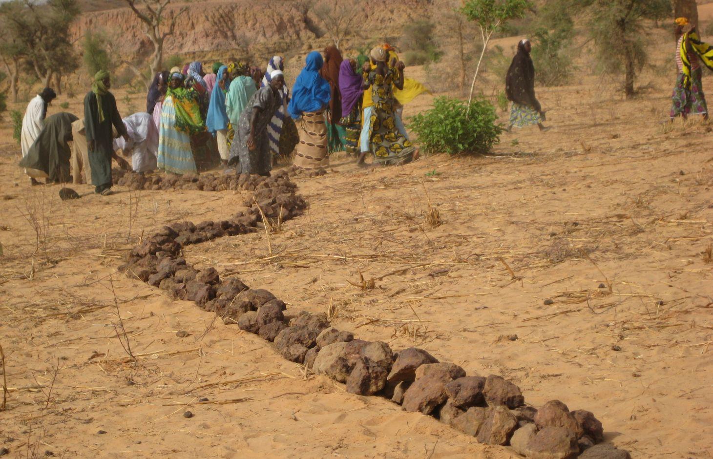
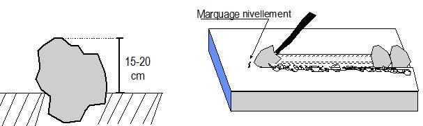
Contour stone bunds are erosion control structures built with quarry rock or stones in series of two or three. They are constructed in lines along the natural contour of the land after 10-15 cm of the soil has been removed from the line where they are to be built. They should be built to a height of 20-30 cm from the ground and spaced 20 to 50 m apart depending on the inclination of the terrain.
The best results are achieved when contour stone bunds are used in combination with biological measures (planting of grass, trees and hedges) and the use of organic fertiliser and mulching.
Purpose of the Technology: Contour stone bunds protect the land against sheet erosion caused by runoff. They form a barrier that slows down runoff and spreads it more evenly over the land. By slowing the flow of water over the land, it can seep into the soil and prevents the loss of rainwater. The bunds also act as a filter, trapping fine waterborne particles of soil and manure, resulting in a build-up of sediment and the formation of terraces. The seeds of grasses and shrubs are also trapped by the bunds, favouring the establishment of natural vegetation along the structure. This further stabilises the soil and the bunds and contributes to conserving the biodiversity of plants and small wild animals (monitor lizards, birds, snakes and other reptiles). If good vegetation cover is developed on the stone bunds, they also lower soil temperature and provide protection against wind erosion. Excess water filters through the bunds and infiltrates into the soil. When rainfall is erratic, the stone bunds contribute to conserving more moisture in the soil for longer, which helps to alleviate water stress during dry spells. There is evidence that bunds that have been in place for over 15 years have positive effects on yields.
Establishment / maintenance activities and inputs: A minimum amount of upkeep is required, which essentially involves replacing stones dislodged by animals or water flow. The lifespan of a stone bund is over 20 years.
In order to optimise the positive effects of stone bunds, it is important to ensure that they are constructed closely following the natural contour of the land and in accordance with the established technical standards.
The means of transport required depends on the proximity of a quarry or a supply of stones (cart or lorry).
Natural / human environment: This technique is designed for cropland, but can also be used on forest/rangeland. It is suitable for areas in the Sahel and the Sudan with rainfall ranging between 300 and 900 mm/year and low-to-medium gradient terrain.
When rainfall is high, they protect the land in the event of heavy rain, a phenomenon that tends to increase with climate change.
2.3 รูปภาพของเทคโนโลยี
อัลบั้มสื่อบันทึก
2.5 ประเทศภูมิภาค หรือสถานที่ตั้งที่เทคโนโลยีได้นำไปใช้และได้รับการครอบคลุมโดยการประเมินนี้
ประเทศ:
ไนเจอร์
ภูมิภาค/รัฐ/จังหวัด:
Niger, Mali, Burkina Faso, Chad
ข้อมูลจำเพาะเพิ่มเติมของสถานที่ตั้ง :
Regions of Tillabéri, Filingué, Ouallam, Téra and Tahuoa
ระบุการกระจายตัวของเทคโนโลยี:
- กระจายไปอย่างสม่ำเสมอในพื้นที่
If precise area is not known, indicate approximate area covered:
- > 10,000 ตร.กม.
แสดงความคิดเห็น:
Large-scale areas have been protected in most Sahel countries. German Development Cooperation (BMZ/GIZ/KfW) for example has had several projects in Chad, Burkina Faso, Niger, Mali, Benin, which have applied stone bunds on around 800.000 to 1.000.000 ha since the 90ies.
Map
×2.6 วันที่การดำเนินการ
ถ้าไม่รู้ปีที่แน่นอน ให้ระบุวันที่โดยประมาณ:
- 10-50 ปี
2.7 คำแนะนำของเทคโนโลยี
ให้ระบุว่าเทคโนโลยีถูกแนะนำเข้ามาอย่างไร:
- ทางโครงการหรือจากภายนอก
ความคิดเห็น (ประเภทของโครงการ เป็นต้น) :
Known as traditional method in some areas. Improved and up-scaled as part of numerous projects in many semi-arid countries. German Developmenmt Cooperation has used the technology from the 1980s onwards to combat desertification and improve natural resource management e.g. PDRT (Projet de développement rural de Tahoua - Tahoua Rural Development Project), PASP (Projet de protection intégrée des ressources agro-sylvo-pastorales Tillabéri-Nord - Project for the Integrated Protection of Agricultural, Forest and Rangeland Resources in Tillabéri-Nord) and several other projects of GIZ/KfW and other donors.
3. การจัดประเภทของเทคโนโลยี SLM
3.1 วัตถุประสงค์หลักของเทคโนโลยี
- ลด ป้องกัน ฟื้นฟู การเสื่อมโทรมของที่ดิน
3.2 ประเภทของการใช้ที่ดินในปัจจุบันที่ได้นำเทคโนโลยีไปใช้
Land use mixed within the same land unit:
ใช่
Specify mixed land use (crops/ grazing/ trees):
- การปลูกพืชร่วมกับปศุสัตว์และการทำป่าไม้ (Agro-silvopastoralism)

พื้นที่ปลูกพืช
- การปลูกพืชล้มลุกอายุปีเดียว
- การปลูกไม้ยืนต้น ไม้พุ่ม
Annual cropping - Specify crops:
- oilseed crops - groundnuts
- cereals - millet
- cereals - sorghum
- legumes and pulses - peas
Tree and shrub cropping - Specify crops:
- mango, mangosteen, guava
จำนวนของฤดูเพาะปลูกต่อปี:
- 1
ระบุ:
Longest growing period in days: 120; Longest growing period from month to month: August to October

ทุ่งหญ้าเลี้ยงสัตว์
Extensive grazing:
- การเลี้ยงสัตว์แบบเร่ร่อนไปตามที่ต่าง ๆ (Nomadism)
- กึ่งโนแมนดิซึ่มหรือแพสโตแรลลิซึ่ม (Semi-nomadism/pastoralism)
ทุ่งหญ้าเลี้ยงสัตว์ที่มีการจัดการแบบเข้มข้นหรือการผลิตอาหารสัตว์:
- ตัดแล้วขนไป / ไม่มีการปล่อยแทะเล็มเอง (Cut-and-carry / zero grazing)
- ทุ่งหญ้าเลี้ยงสัตว์ที่ได้มีการปรับปรุง (Improved pastures)

ป่า/พื้นที่ทำไม้
- ป่ากึ่งธรรมชาติ / พื้นที่ทำไม้
(Semi-)natural forests/ woodlands: Specify management type:
- การตัดไม้ที่มีคัดเลือก (Selective felling)
ผลิตภัณฑ์และบริการ:
- ไม้ซุง
- ไม้ที่นำมาทำเป็นเชื้อเพลิง
- ผลไม้และถั่ว
- ผลิตภัณฑ์อื่น ๆ จากป่า
- การแทะเล็มหญ้า / การเก็บกินหญ้า
แสดงความคิดเห็น:
major cash crop: Ground nut
major food crop: Millet
other: Sorghum, cow pea and mangoes
Major land use problems (compiler’s opinion): surface runoff, erosion by water and wind, fertility decline,
Nomadism: Yes
Semi-nomadism / pastoralism: Yes
Cut-and-carry/ zero grazing: Yes
Improved pasture: Yes
Other grazingland: agropastoralism
Selective felling of (semi-) natural forests: Yes
Forest products and services: timber, fuelwood, fruits and nuts, grazing / browsing, other forest products / uses (honey, medical, etc.)
Type of cropping system and major crops comments: farmers are mainly agropastoralists with some communities specialised on pure pastoralism
Constraints of common grazing land
Constraints of forested government-owned land or commons
Livestock density: 1-10 LU /km2
3.4 การใช้น้ำ
การใช้น้ำของที่ดินที่มีการใช้เทคโนโลยีอยู่:
- จากน้ำฝน
แสดงความคิดเห็น:
Water supply: Also mixed rainfed - irrigated and post-flooding
3.5 กลุ่ม SLM ที่ตรงกับเทคโนโลยีนี้
- มาตรการปลูกพืชขวางความลาดชัน (cross-slope measure)
3.6 มาตรการ SLM ที่ประกอบกันเป็นเทคโนโลยี

มาตรการอนุรักษ์ด้วยโครงสร้าง
- S2: ทำนบ เขื่อนดิน
3.7 รูปแบบหลักของการเสื่อมโทรมของที่ดินที่ได้รับการแก้ไขโดยเทคโนโลยี

การกัดกร่อนของดินโดยน้ำ
- Wt (Loss of topsoil): การสูญเสียดินชั้นบนหรือการกัดกร่อนที่ผิวดิน
- Wg (Gully erosion): การกัดกร่อนแบบร่องธารหรือการทำให้เกิดร่องน้ำเซาะ
- Wo (Offsite degradation): ผลกระทบนอกพื้นที่

การกัดกร่อนของดินโดยลม
- Et (Loss of topsoil): การสูญเสียดินชั้นบน

การเสื่อมโทรมของดินทางด้านเคมี
- Cn (Fertility decline): ความอุดมสมบูรณ์และปริมาณอินทรียวัตถุในดินถูกทำให้ลดลงไป (ไม่ได้เกิดจากสาเหตุการกัดกร่อน)

การเสื่อมโทรมของดินทางด้านชีวภาพ
- Bc (Reduction of vegetation cover): การลดลงของจำนวนพืชที่ปกคลุมดิน

การเสื่อมโทรมของน้ำ
- Hs (Change in quantity of surface water): การเปลี่ยนแปลงปริมาณของน้ำที่ผิวดิน
แสดงความคิดเห็น:
Secondary types of degradation addressed: Et: loss of topsoil
Main causes of degradation: soil management (Unadapted landuse methods, reduced or abandoned fallow periods), crop management (annual, perennial, tree/shrub) (Neglect of fallow periods and crop rotation), droughts (due to heat waves and unreliable rainfall), population pressure (rapidly growing population increasing pressure on land), land tenure (insecure access to land and collectively managed communal land), poverty / wealth (very poor population)
Secondary causes of degradation: deforestation / removal of natural vegetation (incl. forest fires) (deforestation through overgrazing and fire wood collection), over-exploitation of vegetation for domestic use (firewood collection), overgrazing (cattle, sheep and goats), change in temperature (Climate change: heat waves), change of seasonal rainfall (more variable onset of rain), Heavy / extreme rainfall (intensity/amounts) (more variable and intensive rains), wind storms / dust storms (frequent storms), floods (due to intensive rain storms), labour availability (some migration of men to nearby cities), education, access to knowledge and support services (high level of illiteracy)
3.8 การป้องกัน การลดลง หรือการฟื้นฟูความเสื่อมโทรมของที่ดิน
ระบุเป้าหมายของเทคโนโลยีกับความเสื่อมโทรมของที่ดิน:
- ฟื้นฟูบำบัดที่ดินที่เสื่อมโทรมลงอย่างมาก
แสดงความคิดเห็น:
Secondary goals: prevention of land degradation, mitigation / reduction of land degradation
4. ข้อมูลจำเพาะด้านเทคนิค กิจกรรมการนำไปปฏิบัติใช้ ปัจจัยนำเข้า และค่าใช้จ่าย
4.1 แบบแปลนทางเทคนิคของเทคโนโลยี
ข้อมูลจำเพาะด้านเทคนิค (แบบแปลนทางเทคนิคของเทคโนโลยี):
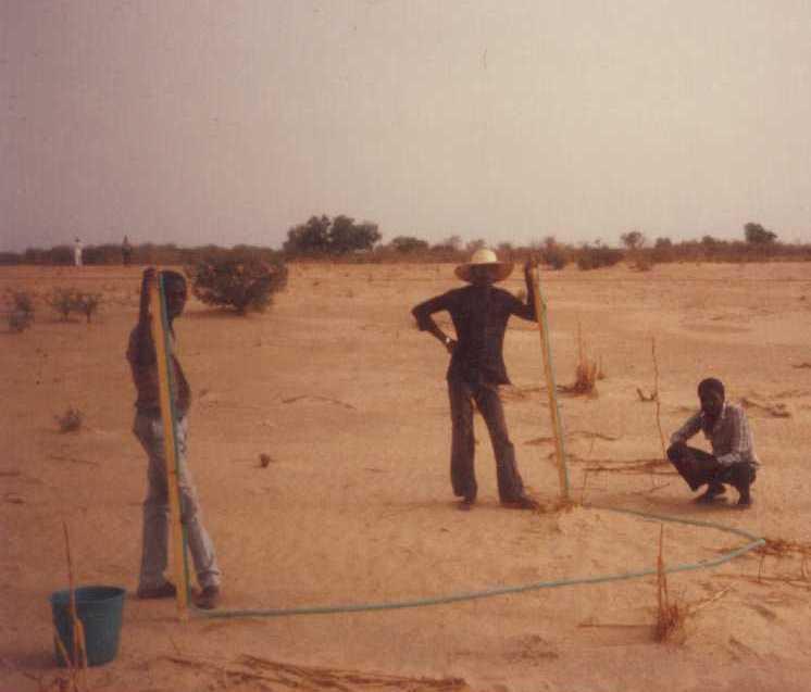
Contour stone bunds are built with quarry rock or stones in series of two or three. They are constructed in lines along the natural contour of the land after 10-15 cm of the soil has been removed from the line where they are to be built. They should be built to a height of 20-30 cm from the ground and spaced 20 to 50 m apart. The best results are achieved when contour stone bunds are used in combination with biological measures (planting of grass, trees and hedges) and the use of organic fertiliser and mulching.
Technical knowledge required for field staff / advisors: moderate
Technical knowledge required for land users: low
Main technical functions: control of dispersed runoff: retain / trap, control of dispersed runoff: impede / retard, control of concentrated runoff: retain / trap, control of concentrated runoff: impede / retard, stabilisation of soil (eg by tree roots against land slides), increase of infiltration, increase / maintain water stored in soil, water harvesting / increase water supply
Secondary technical functions: reduction of slope angle, improvement of ground cover, increase in nutrient availability (supply, recycling,…), increase of groundwater level / recharge of groundwater, sediment retention / trapping, sediment harvesting, reduction in wind speed, increase of biomass (quantity)
Bund/ bank: graded
Spacing between structures (m): 20-50
Height of bunds/banks/others (m): 0.2-0.3
Length of bunds/banks/others (m): 0.2
Material: Stone
ผู้เขียน:
PASP, GIZ
4.2 ข้อมูลทั่วไปเกี่ยวกับการคำนวณปัจจัยนำเข้าและค่าใช้จ่าย
ระบุสกุลเงินที่ใช้คำนวณค่าใช้จ่าย:
- USD
4.3 กิจกรรมเพื่อการจัดตั้ง
| กิจกรรม | Timing (season) | |
|---|---|---|
| 1. | Levelling and marking out the contour lines | |
| 2. | collecting stones and loading them onto carts | |
| 3. | transporting the stones by cart | |
| 4. | constructing the bunds | |
| 5. | applying manure |
4.4 ค่าใช้จ่ายของปัจจัยนำเข้าที่จำเป็นสำหรับการจัดตั้ง
| ปัจจัยนำเข้า | หน่วย | ปริมาณ | ค่าใช้จ่ายต่อหน่วย | ค่าใช้จ่ายทั้งหมดต่อปัจจัยนำเข้า | %ของค่าใช้จ่ายที่ก่อให้เกิดขึ้นโดยผู้ใช้ที่ดิน | |
|---|---|---|---|---|---|---|
| แรงงาน | Levelling and construction of bunds | ha | 1.0 | 19.32 | 19.32 | |
| อุปกรณ์ | Tools | ha | 1.0 | 1.95 | 1.95 | |
| อื่น ๆ | Transport of stones | ha | 1.0 | 15.07 | 15.07 | |
| ค่าใช้จ่ายทั้งหมดของการจัดตั้งเทคโนโลยี | 36.34 | |||||
| Total costs for establishment of the Technology in USD | 36.34 | |||||
4.5 การบำรุงรักษาสภาพหรือกิจกรรมที่เกิดขึ้นเป็นประจำ
| กิจกรรม | ช่วงระยะเวลา/ความถี่ | |
|---|---|---|
| 1. | Replacing stones dislodged by animals or water flow |
4.7 ปัจจัยสำคัญที่สุดที่มีผลกระทบต่อค่าใช้จ่าย
ปัจจัยสำคัญที่สุดที่มีผลกระทบต่อค่าใช้จ่ายต่างๆ:
The exact cost per hectare of constructing stone bunds depends on the distance of the site from the quarry, the size of the quarry, the inclination of the terrain, which determines the spacing between the stone bunds, and the actual amount of stones transported in each lorryload. The prices below are provided as a guide.
Supply of quarry rock/stones: 24 m3 per 400 m of bund
Labour: 30 man-days per ha
• levelling and marking out the contour lines: 1 man-day
• collecting stones and loading them onto carts:
10 man-days
• transporting the stones by cart: 10 man-days
• constructing the bunds: 9 man-days
• applying manure.
Transportation by cart:
• 20 cartloads of stones
• 20 cartloads of manure (if used).
Transportation by lorry:
• 6 lorryloads (skip loader – 4.5 m3 per load).
Other costs: equipment (pickaxes, shovels, wheelbarrows, water-tube level, etc.).
5. สิ่งแวดล้อมทางธรรมชาติและของมนุษย์
5.1 ภูมิอากาศ
ฝนประจำปี
- < 250 ม.ม.
- 251-500 ม.ม.
- 501-750 ม.ม.
- 751-1,000 ม.ม.
- 1,001-1,500 ม.ม.
- 1,501-2,000 ม.ม.
- 2,001-3,000 ม.ม.
- 3,001-4,000 ม.ม.
- > 4,000 ม.ม.
เขตภูมิอากาศเกษตร
- กึ่งแห้งแล้ง
Thermal climate class: subtropics
5.2 สภาพภูมิประเทศ
ค่าเฉลี่ยความลาดชัน:
- ราบเรียบ (0-2%)
- ลาดที่ไม่ชัน (3-5%)
- ปานกลาง (6-10%)
- เป็นลูกคลื่น (11-15%)
- เป็นเนิน (16-30%)
- ชัน (31-60%)
- ชันมาก (>60%)
ธรณีสัณฐาน:
- ที่ราบสูง/ที่ราบ
- สันเขา
- ไหล่เขา
- ไหล่เนินเขา
- ตีนเนิน
- หุบเขา
ระดับความสูง:
- 0-100 เมตร
- 101-500 เมตร
- 501-1,000 เมตร
- 1,001-1,500 เมตร
- 1,501-2,000 เมตร
- 2,001-2,500 เมตร
- 2,501-3,000 เมตร
- 3,001-4,000 เมตร
- > 4,000 เมตร
ความคิดเห็นและข้อมูลจำเพาะเพิ่มเติมเรื่องสภาพภูมิประเทศ:
Landforms: Also footslopes and valley floors
Altitudinal zone: 200 m a.s.l.
5.3 ดิน
ค่าเฉลี่ยความลึกของดิน:
- ตื้นมาก (0-20 ซ.ม.)
- ตื้น (21-50 ซ.ม.)
- ลึกปานกลาง (51-80 ซ.ม.)
- ลึก (81-120 ซ.ม.)
- ลึกมาก (>120 ซ.ม.)
เนื้อดิน (ดินชั้นบน):
- ปานกลาง (ดินร่วน ทรายแป้ง)
- ละเอียด/หนัก (ดินเหนียว)
อินทรียวัตถุในดิน:
- ต่ำ (<1%)
(ถ้ามี) ให้แนบคำอธิบายเรื่องดินแบบเต็มหรือระบุข้อมูลที่มีอยู่ เช่น ชนิดของดิน ค่า pH ของดินหรือความเป็นกรดของดิน ความสามารถในการแลกเปลี่ยนประจุบวก ไนโตรเจน ความเค็ม เป็นต้น:
Soil texture (topsoil): Fine to medium (sandy to clayey loams)
5.4 ความเป็นประโยชน์และคุณภาพของน้ำ
ระดับน้ำใต้ดิน:
5-50 เมตร
น้ำไหลบ่าที่ผิวดิน:
ปานกลาง
คุณภาพน้ำ (ที่ยังไม่ได้บำบัด):
เป็นน้ำใช้เพื่อการเกษตรเท่านั้น (การชลประทาน)
ความคิดเห็นและข้อมูลจำเพาะเพิ่มเติมเรื่องคุณภาพและปริมาณน้ำ:
Ground water table: > 10 m
Availability of surface water: Surface runoff generated by limited but intense rainfalls
5.5 ความหลากหลายทางชีวภาพ
ความหลากหลายทางชนิดพันธุ์:
- ต่ำ
5.6 ลักษณะของผู้ใช้ที่ดินที่นำเทคโนโลยีไปปฏิบัติใช้
แนวทางการตลาดของระบบการผลิต:
- เพื่อการยังชีพ (หาเลี้ยงตนเอง)
- mixed (subsistence/ commercial)
รายได้ที่มาจากนอกฟาร์ม:
- 10-50% ของรายได้ทั้งหมด
ระดับของความมั่งคั่งโดยเปรียบเทียบ:
- ยากจนมาก
- จน
ระดับของการใช้เครื่องจักรกล:
- งานที่ใช้แรงกาย
- การใช้กำลังจากสัตว์
เพศ:
- ชาย
ระบุลักษณะอื่นๆที่เกี่ยวข้องของผู้ใช้ที่ดิน:
Population density: 10-50 persons/km2
Annual population growth: 3% - 4%
(mostly poor households below poverty line).
Off-farm income specification: men migrate temporarily or permanently to cities for off-farm income, women and men seasonally carry out paid farm work
Market orientation of production system: Most households crop for subsistence (mainly for small agropastoralists) and surplus is sold on market (medium agropastoralists). Commercial markets: some vegetable growing and pastoralists.
Level of mechanization: Ox and donkey used for animal traction
5.7 Average area of land used by land users applying the Technology
- < 0.5 เฮกตาร์
- 0.5-1 เฮกตาร์
- 1-2 เฮกตาร์
- 2-5 เฮกตาร์
- 5-15 เฮกตาร์
- 15-50 เฮกตาร์
- 50-100 เฮกตาร์
- 100-500 เฮกตาร์
- 500-1,000 เฮกตาร์
- 1,000-10,000 เฮกตาร์
- >10,000 เฮกตาร์
พิจารณาว่าเป็นขนาดเล็ก กลาง หรือขนาดใหญ่ (ซึ่งอ้างอิงถึงบริบทระดับท้องถิ่น):
- ขนาดเล็ก
แสดงความคิดเห็น:
Average area of land owned or leased by land users applying the Technology: Also 1-2 ha
5.8 กรรมสิทธิ์ในที่ดิน สิทธิในการใช้ที่ดินและสิทธิในการใช้น้ำ
กรรมสิทธิ์ในที่ดิน:
- รัฐ
- เป็นแบบชุมชนหรือหมู่บ้าน
สิทธิในการใช้ที่ดิน:
- เกี่ยวกับชุมชน (ถูกจัดระเบียบ)
- รายบุคคล
แสดงความคิดเห็น:
traditional land use rights prevail. On fields individual land use rights, communal rights on pasture and forest land (collection of wood and other products (fruits, medicinal plants))
Land ownership: Also individual not titled
5.9 การเข้าถึงบริการและโครงสร้างพื้นฐาน
สุขภาพ:
- จน
- ปานกลาง
- ดี
การศึกษา:
- จน
- ปานกลาง
- ดี
ความช่วยเหลือทางด้านเทคนิค:
- จน
- ปานกลาง
- ดี
การจ้างงาน (เช่น ภายนอกฟาร์ม):
- จน
- ปานกลาง
- ดี
ตลาด:
- จน
- ปานกลาง
- ดี
พลังงาน:
- จน
- ปานกลาง
- ดี
ถนนและการขนส่ง:
- จน
- ปานกลาง
- ดี
น้ำดื่มและการสุขาภิบาล:
- จน
- ปานกลาง
- ดี
บริการด้านการเงิน:
- จน
- ปานกลาง
- ดี
6. ผลกระทบและสรุปคำบอกกล่าว
6.1 ผลกระทบในพื้นที่ดำเนินการ (On-site) จากการใช้เทคโนโลยี
ผลกระทบทางด้านเศรษฐกิจและสังคม
การผลิต
การผลิตพืชผล
การผลิตพืชที่ใช้เลี้ยงปศุสัตว์
การเสี่ยงต่อความล้มเหลวในการผลิต
ความเป็นประโยชน์และคุณภาพของน้ำ
ความต้องการน้ำจากการชลประทาน
รายได้และค่าใช้จ่าย
ค่าใช่จ่ายของปัจจัยการผลิตทางการเกษตร
รายได้จากฟาร์ม
ผลกระทบด้านสังคมวัฒนธรรมอื่น ๆ
ความมั่นคงด้านอาหาร / พึ่งตนเองได้
SLM หรือความรู้เรื่องความเสื่อมโทรมของที่ดิน
livelihood and human well-being
แสดงความคิดเห็น/ระบุ:
There is evidence that 15 year old bunds still maintain their positive effects on yields. 40 % higher grain yields were measured on such bunds and there is no evidence to suggest that yields decline with time. In dry years, while unimproved land produces nothing, land protected by stone bunds can still produce a harvest. Higher crop production improves household food security in proportion to the area of a farm improved with bunds. Under the PASP in Niger, an average of 16% of the area of a farm was improved with stone bunds, resulting in an increase of between 8% and 33% in annual output with no other additional measures.
ผลกระทบด้านนิเวศวิทยา
วัฐจักรน้ำหรือน้ำบ่า
การเก็บเกี่ยวหรือการกักเก็บน้ำ
น้ำไหลบ่าที่ผิวดิน
ดิน
ความชื้นในดิน
สิ่งปกคลุมดิน
การสูญเสียดิน
การหมุนเวียนและการเติมของธาตุอาหาร
ความหลากหลายทางชีวภาพของพืชและสัตว์
ความหลากหลายทางชีวภาพของพืช
ลดความเสี่ยงของภัยพิบัติ
ความเร็วของลม
ผลกระทบด้านนิเวศวิทยาอื่น ๆ
hazard towards adverse events
6.2 ผลกระทบนอกพื้นที่ดำเนินการ (Off-site) จากการใช้เทคโนโลยี
การทับถมของดินตะกอนพื้นที่ท้ายน้ำ
ตะกอนที่ถูกพัดพามาโดยลม
ความเสียหายต่อพื้นที่เพาะปลูกของเพื่อนบ้าน
6.3 การเผชิญและความตอบสนองของเทคโนโลยีต่อการเปลี่ยนแปลงสภาพภูมิอากาศที่ค่อยเป็นค่อยไป และสภาพรุนแรงของภูมิอากาศ / ภัยพิบัติ (ที่รับรู้ได้โดยผู้ใช้ที่ดิน)
การเปลี่ยนแปลงสภาพภูมิอากาศที่ค่อยเป็นค่อยไป
การเปลี่ยนแปลงสภาพภูมิอากาศที่ค่อยเป็นค่อยไป
| ฤดู | increase or decrease | เทคโนโลยีมีวิธีการรับมืออย่างไร | |
|---|---|---|---|
| อุณหภูมิประจำปี | เพิ่มขึ้น | ดี |
สภาพรุนแรงของภูมิอากาศ (ภัยพิบัติ)
ภัยพิบัติทางอุตุนิยมวิทยา
| เทคโนโลยีมีวิธีการรับมืออย่างไร | |
|---|---|
| พายุฝนประจำท้องถิ่น | ไม่ค่อยดี |
| พายุลมประจำท้องถิ่น | ดี |
ภัยพิบัติจากสภาพภูมิอากาศ
| เทคโนโลยีมีวิธีการรับมืออย่างไร | |
|---|---|
| ภัยจากฝนแล้ง | ดี |
ภัยพิบัติจากน้ำ
| เทคโนโลยีมีวิธีการรับมืออย่างไร | |
|---|---|
| น้ำท่วมตามปกติ (แม่น้ำ) | ไม่ค่อยดี |
ผลลัพธ์ตามมาที่เกี่ยวข้องกับภูมิอากาศอื่น ๆ
ผลลัพธ์ตามมาที่เกี่ยวข้องกับภูมิอากาศอื่น ๆ
| เทคโนโลยีมีวิธีการรับมืออย่างไร | |
|---|---|
| ช่วงการปลูกพืชที่ลดลงมา | ไม่ทราบ |
6.4 การวิเคราะห์ค่าใช้จ่ายและผลประโยชน์ที่ได้รับ
ผลประโยชน์ที่ได้รับเปรียบเทียบกับค่าใช้จ่ายในการจัดตั้งเป็นอย่างไร (จากมุมมองของผู้ใช้ที่ดิน)
ผลตอบแทนระยะสั้น:
ด้านบวก
ผลตอบแทนระยะยาว:
ด้านบวกอย่างมาก
ผลประโยชน์ที่ได้รับเปรียบเทียบกับค่าใช้จ่ายในการบำรุงรักษาหรือต้นทุนที่เกิดขึ้นซ้ำอีก เป็นอย่างไร (จากมุมมองของผู้ใช้ที่ดิน)
ผลตอบแทนระยะสั้น:
ด้านบวกอย่างมาก
ผลตอบแทนระยะยาว:
ด้านบวกอย่างมาก
6.5 การปรับตัวของเทคโนโลยี
Of all those who have adopted the Technology, how many did so spontaneously, i.e. without receiving any material incentives/ payments?
- 51-90%
แสดงความคิดเห็น:
Comments on acceptance with external material support: While in emergency programs erosion control structures are mostly implemented through cash/food for work this is not the case in natural resource programs. As concerns German Development Cooperation, cash/food for work has been used during the 80ies and 90ies to implement stone bunds. Thereafter most programs switched to a voluntary approach where only Tools and transport were provided but all labour has been provided by the beneficiaries without payment.
80% of land user families have adopted the Technology without any external material support
There is a little trend towards spontaneous adoption of the Technology
Comments on adoption trend: The success of this measure and implementation on a wide scale depend to a large extent on whether grants are available to cover the cost of transporting the stones required to the site, good community organisation and the capacity of the community to mobilise the necessary labour, the contribution required from the farmers.
The farmers’ commitment to implementing the measure largely depends on whether they are allowed to choose the sites to be improved in their area. Forcing them to begin the improvement work upstream, as dictated by the traditional watershed development approach, has often proved counterproductive. Most communities prefer to improve individual plots first in order to achieve immediate effects on crop production and leave the treatment of forest/ rangeland areas as a second step.
6.7 จุดแข็ง / ข้อได้เปรียบ / โอกาสของเทคโนโลยี
| จุดแข็ง / ข้อได้เปรียบ / โอกาสในทัศนคติของผู้รวบรวมหรือวิทยากรหลัก |
|---|
| There is evidence that bunds that have been in place for over 15 years have positive effects on yields. Grain yields increase by more than 40% for millet up to 15 years after the bunds were established, and there is no evidence to suggest that yields decline with time. This can be explained by improved soil structure, which increases infiltration, even after the bunds are completely silted up. |
|
The lifespan of a stone bund is over 20 years. There is a progressive build-up of sediment behind the bunds, resulting in the formation of terraces. Although the capacity of the bunds to retain water declines as the sediment builds up, soil infiltration capacity increases, thanks to improved soil structure, and the slope becomes gentler thanks to the terracing effect. How can they be sustained / enhanced? Farmers can maintain water retention capacity by raising the height of the existing bunds. In some places, farmers take the stones from the original bunds when a ridge of vegetation has been established and use them to form new bunds between the old ones. |
|
The decrease in surface runoff in the treated area reduces the flow of floodwater and the amount of sediment carried by the water downstream, thereby protecting the fertile land in the valley bottoms from siltation and gully erosion. How can they be sustained / enhanced? In order to optimise the positive effects of stone bunds, it is important to ensure that they are constructed closely following the natural contour of the land and in accordance with the established technical standards. |
|
In dry years, while unimproved land produces nothing, land protected by stone bunds can still produce a harvest. How can they be sustained / enhanced? When stone bunds are used in combination with zai planting pits, sorghum yields can increase by 114-124%. When used in conjunction with the application of the right amount of organic fertiliser, sorghum yields can be doubled. |
| Higher crop production improves household food security in proportion to the area of a farm improved with bunds. Under the PASP in Niger, an average of 16% of the area of a farm was improved with stone bunds, resulting in an increase of between 8% and 33% in annual output with no other additional measures. |
6.8 จุดอ่อน / ข้อเสียเปรียบ / ความเสี่ยงของเทคโนโลยีและวิธีการแก้ไข
| จุดอ่อน / ข้อเสียเปรียบ / ความเสี่ยงในทัศนคติของผู้รวบรวมหรือวิทยากรหลัก | มีวิธีการแก้ไขได้อย่างไร |
|---|---|
| In wet years, the bunds may cause waterlogging in some parts of the field, which can adversely affect some crops. | If this happens, farmers must open up a gap in the bunds to drain off the water. |
7. การอ้างอิงและการเชื่อมต่อ
7.1 วิธีการและแหล่งข้อมูล
7.3 Links to relevant online information
ชื่อเรื่องหรือคำอธิบาย:
Good Practices in Soil and Water Conservation. A contribution to adaptation and farmers resilience towards climate change in the Sahel. Published by GIZ in 2012.
URL:
http://agriwaterpedia.info/wiki/Main_Page
ลิงก์และโมดูล
ขยายทั้งหมด ย่อทั้งหมดลิงก์
ไม่มีลิงก์
โมดูล
ไม่มีโมดูล