Dejen Stone Bund [เอธิโอเปีย]
- ผู้สร้างสรรค์:
- การอัพเดท:
- ผู้รวบรวม: Unknown User
- ผู้เรียบเรียง: –
- ผู้ตรวจสอบ: Fabian Ottiger
Gidad, Irken
technologies_1059 - เอธิโอเปีย
ดูส่วนย่อย
ขยายทั้งหมด ย่อทั้งหมด1. ข้อมูลทั่วไป
1.3 เงื่อนไขการใช้ข้อมูลที่ได้บันทึกผ่านทาง WOCAT
วันที่เก็บรวบรวมข้อมูล(ภาคสนาม) :
10/10/2005
ผู้รวบรวมและวิทยากรหลักยอมรับเงื่อนไขเกี่ยวกับการใช้ข้อมูลที่ถูกบันทึกผ่านทาง WOCAT:
ใช่
2. การอธิบายลักษณะของเทคโนโลยี SLM
2.1 การอธิบายแบบสั้น ๆ ของเทคโนโลยี
คำจำกัดความของเทคโนโลยี:
Stone bund is an enbankment of stone constructed acrros the slope following the contour.
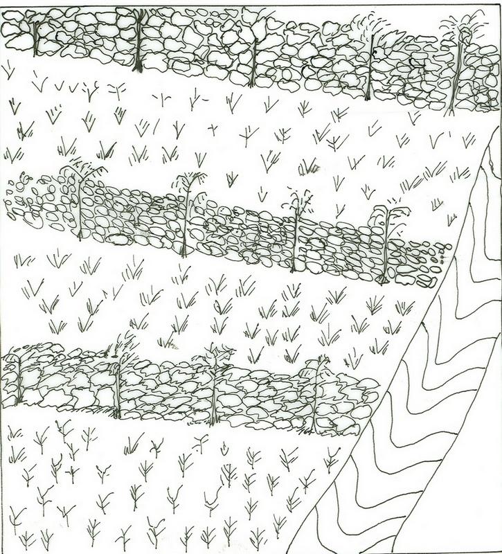
2.2 การอธิบายแบบละเอียดของเทคโนโลยี
คำอธิบาย:
It is a stone wall stablized with grasses and fodder plant species. Its main purpose is moisture harvesting and soil erosion control. Establishment is made first by laying out contour lines, digging foundation and placing of stones in a manner to interlock to each other. Stone bunds placed on contour are known as level stone bunds. The purpose is to arrest runoff and enhance soil moisture to increaseavailability of water to plants. It is also aimed at controlling soil erosion from cultivated fields such that the plants have sufficient soil depth to establish and grow. Maintenance is done every year especially before thev rains. Maintenance continues for several years until the slope of the terraced land forms nearly level bench or slightly sloping outward terrace. The technology is suitable to semi-arid and arid climatic conditions having steep to very steep cultivated lands. It is suitable to major annual cereal crops, perennial crops, fruit trees and cash crops.
2.3 รูปภาพของเทคโนโลยี
อัลบั้มสื่อบันทึก
2.5 ประเทศภูมิภาค หรือสถานที่ตั้งที่เทคโนโลยีได้นำไปใช้และได้รับการครอบคลุมโดยการประเมินนี้
ประเทศ:
เอธิโอเปีย
ภูมิภาค/รัฐ/จังหวัด:
Amhara/Dejen
ข้อมูลจำเพาะเพิ่มเติมของสถานที่ตั้ง :
Dejen-Inemay
Map
×2.6 วันที่การดำเนินการ
ถ้าไม่รู้ปีที่แน่นอน ให้ระบุวันที่โดยประมาณ:
- น้อยกว่า 10 ปี (ไม่นานนี้)
2.7 คำแนะนำของเทคโนโลยี
ให้ระบุว่าเทคโนโลยีถูกแนะนำเข้ามาอย่างไร:
- ทางโครงการหรือจากภายนอก
ความคิดเห็น (ประเภทของโครงการ เป็นต้น) :
Originally it is indiginous and now some improvement techniques have been included.
3. การจัดประเภทของเทคโนโลยี SLM
3.1 วัตถุประสงค์หลักของเทคโนโลยี
- ปรับปรุงการผลิตให้ดีขึ้น
- ลด ป้องกัน ฟื้นฟู การเสื่อมโทรมของที่ดิน
3.2 ประเภทของการใช้ที่ดินในปัจจุบันที่ได้นำเทคโนโลยีไปใช้

พื้นที่ปลูกพืช
- การปลูกพืชล้มลุกอายุปีเดียว
พืชหลัก (พืชเศรษฐกิจและพืชอาหาร):
Major food crop annual cropping: sorghum
Major cash crop perennial (non-woody) cropping: sugar cane, fruit trees
แสดงความคิดเห็น:
Major land use problems (compiler’s opinion): Overgrazing with little vegetation cover and exposed surface, cultivating on very steep slopes.
Major land use problems (land users’ perception): Low productivity of land, erosion, low soil fertility and surface stoniness.
Type of cropping system and major crops comments: sorghum-teff-sorghum
3.3 ข้อมูลเพิ่มเติมเกี่ยวกับการใช้ที่ดิน
การใช้น้ำของที่ดินที่มีการใช้เทคโนโลยีอยู่:
- จากน้ำฝน
แสดงความคิดเห็น:
Water supply: Also mixed rainfed - irrigated
จำนวนของฤดูเพาะปลูกต่อปี:
- 1
ระบุ:
Longest growing period in days: 210
3.4 กลุ่ม SLM ที่ตรงกับเทคโนโลยีนี้
- มาตรการปลูกพืชขวางความลาดชัน (cross-slope measure)
3.5 กระจายตัวของเทคโนโลยี
แสดงความคิดเห็น:
Total area covered by the SLM Technology is 10 m2.
The technology is applied mostly on the low land part of the woreda.
3.6 มาตรการ SLM ที่ประกอบกันเป็นเทคโนโลยี
3.7 รูปแบบหลักของการเสื่อมโทรมของที่ดินที่ได้รับการแก้ไขโดยเทคโนโลยี

การกัดกร่อนของดินโดยน้ำ
- Wt (Loss of topsoil): การสูญเสียดินชั้นบนหรือการกัดกร่อนที่ผิวดิน
- Wg (Gully erosion): การกัดกร่อนแบบร่องธารหรือการทำให้เกิดร่องน้ำเซาะ

การเสื่อมโทรมของดินทางด้านเคมี
- Cn (Fertility decline): ความอุดมสมบูรณ์และปริมาณอินทรียวัตถุในดินถูกทำให้ลดลงไป (ไม่ได้เกิดจากสาเหตุการกัดกร่อน)
แสดงความคิดเห็น:
Main type of degradation addressed: Wt: loss of topsoil / surface erosion
Secondary types of degradation addressed: Wg: gully erosion / gullying, Cn: fertility decline and reduced organic matter content
3.8 การป้องกัน การลดลง หรือการฟื้นฟูความเสื่อมโทรมของที่ดิน
ระบุเป้าหมายของเทคโนโลยีกับความเสื่อมโทรมของที่ดิน:
- ลดความเสื่อมโทรมของดิน
แสดงความคิดเห็น:
Secondary goals: prevention of land degradation, rehabilitation / reclamation of denuded land
4. ข้อมูลจำเพาะด้านเทคนิค กิจกรรมการนำไปปฏิบัติใช้ ปัจจัยนำเข้า และค่าใช้จ่าย
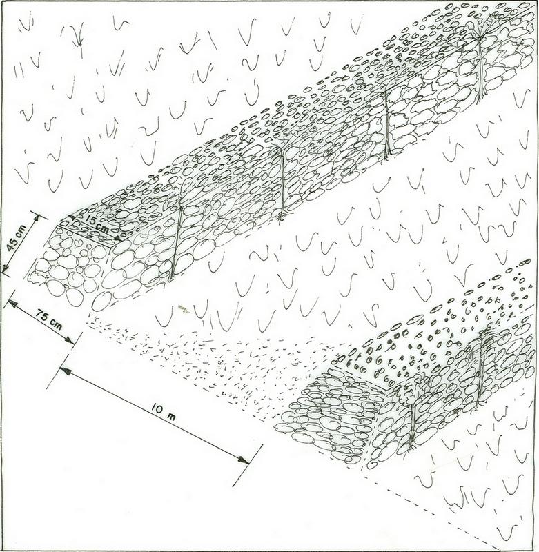
4.1 แบบแปลนทางเทคนิคของเทคโนโลยี
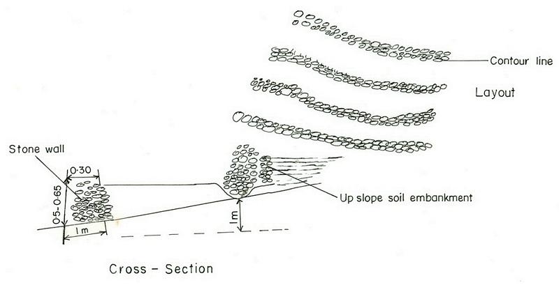
4.2 ข้อมูลจำเพาะด้านเทคนิคและการอธิบายแบบแปลนทางเทคนิค
Amhara
Technical knowledge required for field staff / advisors: moderate
Technical knowledge required for land users: moderate
Main technical functions: control of dispersed runoff: retain / trap
Secondary technical functions: reduction of slope angle, reduction of slope length, increase of infiltration, water harvesting / increase water supply
Better crop cover
Material/ species: Sorghum, Teff, Suflower
Remarks: broad cast
Contour planting / strip cropping
Material/ species: Sesbania, leucaena
Remarks: by planting across the slope
Agronomic measure: removing less vegetation cover
Material/ species: Crop residue, grasses
Remarks: across the slope
Mineral (inorganic) fertilizers
Material/ species: DAP/Urea
Quantity/ density: 150 Kg/ha
Remarks: Sown by broadcasting
Contour tillage
Remarks: oxen plough
Pits
Remarks: hand pick axe
Aligned: -contour
Vegetative material: T : trees / shrubs
Number of plants per (ha): 1500
Vertical interval between rows / strips / blocks (m): 1m
Spacing between rows / strips / blocks (m): 5 m
Vertical interval within rows / strips / blocks (m): 1m
Width within rows / strips / blocks (m): 2m
Scattered / dispersed
Vegetative material: T : trees / shrubs
Number of plants per (ha): 500
Spacing between rows / strips / blocks (m): 5m
Width within rows / strips / blocks (m): 10m
Trees/ shrubs species: sesbania
Grass species: local
Slope (which determines the spacing indicated above): 15.00%
If the original slope has changed as a result of the Technology, the slope today is (see figure below): 10.00%
Gradient along the rows / strips: 0.00%
Bund/ bank: level
Vertical interval between structures (m): 2m
Spacing between structures (m): 10m
Height of bunds/banks/others (m): 0.45m
Width of bunds/banks/others (m): 0.45m
Length of bunds/banks/others (m): 80m
Structural measure: diversion ditch / cut-off drain
Depth of ditches/pits/dams (m): 0.4m
Width of ditches/pits/dams (m): 0.3m
Length of ditches/pits/dams (m): 58m
Height of bunds/banks/others (m): 0.75m
Width of bunds/banks/others (m): 1.0m
Length of bunds/banks/others (m): 58m
Construction material (earth): reinforce the stone embankment
Construction material (stone): strengthen/support the terrace wall
Slope (which determines the spacing indicated above): 15%
If the original slope has changed as a result of the Technology, the slope today is: 10%
Lateral gradient along the structure: 0%
Vegetation is used for stabilisation of structures.
Other type of management: change of management / intensity level - from random/open access to controlled system
4.3 ข้อมูลทั่วไปเกี่ยวกับการคำนวณปัจจัยนำเข้าและค่าใช้จ่าย
อื่นๆ หรือสกุลเงินประจำชาติ (ระบุ):
Birr
ระบุอัตราแลกเปลี่ยนจากดอลลาร์สหรัฐเป็นสกุลเงินท้องถิ่น (ถ้าเกี่ยวข้อง) คือ 1 เหรียญสหรัฐ =:
8.6
ระบุค่าเฉลี่ยของค่าจ้างในการจ้างแรงงานต่อวัน:
0.70
4.4 กิจกรรมเพื่อการจัดตั้ง
| กิจกรรม | ประเภทของมาตรการ | ช่วงเวลาดำเนินการ | |
|---|---|---|---|
| 1. | preparation of seedlings | ด้วยวิธีพืช | dry season |
| 2. | transporting of seedlings | ด้วยวิธีพืช | rainy season |
| 3. | plantation on bund | ด้วยวิธีพืช | rainy season |
| 4. | surveying | ด้วยโครงสร้าง | dry season |
| 5. | collecting of stones | ด้วยโครงสร้าง | dry season |
| 6. | constructing the bund | ด้วยโครงสร้าง | dry season |
| 7. | Seek solution for the management problems | ด้วยการจัดการ | before harvesting |
| 8. | controlling the development activities by guarding from free grazing animals. | ด้วยการจัดการ | after harvesting |
| 9. | discussing on management and measures | ด้วยการจัดการ | before harvesting |
4.5 ค่าใช้จ่ายของปัจจัยนำเข้าที่จำเป็นสำหรับการจัดตั้ง
| ปัจจัยนำเข้า | หน่วย | ปริมาณ | ค่าใช้จ่ายต่อหน่วย | ค่าใช้จ่ายทั้งหมดต่อปัจจัยนำเข้า | %ของค่าใช้จ่ายที่ก่อให้เกิดขึ้นโดยผู้ใช้ที่ดิน | |
|---|---|---|---|---|---|---|
| แรงงาน | Labour | ha | 1.0 | 236.0 | 236.0 | 100.0 |
| อุปกรณ์ | Tools | ha | 1.0 | 6.0 | 6.0 | 100.0 |
| วัสดุด้านพืช | Seedlings | ha | 1.0 | 58.0 | 58.0 | 100.0 |
| วัสดุสำหรับก่อสร้าง | Stone | ha | 1.0 | 83.0 | 83.0 | 100.0 |
| ค่าใช้จ่ายทั้งหมดของการจัดตั้งเทคโนโลยี | 383.0 | |||||
แสดงความคิดเห็น:
Duration of establishment phase: 24 month(s)
4.6 การบำรุงรักษาสภาพหรือกิจกรรมที่เกิดขึ้นเป็นประจำ
| กิจกรรม | ประเภทของมาตรการ | ช่วงระยะเวลา/ความถี่ | |
|---|---|---|---|
| 1. | Contour ploughing | จัดการพืช | dry season / three times |
| 2. | Harrowing | จัดการพืช | dry season / one time |
| 3. | Planting | จัดการพืช | wet season / one time |
| 4. | Temporary trashline | จัดการพืช | dry -rainy season / |
| 5. | Residues | จัดการพืช | dry season / many times |
| 6. | Weeding | จัดการพืช | rainy season / two times |
| 7. | Harvest | จัดการพืช | dry season / annual |
| 8. | cutting/prunnig | ด้วยวิธีพืช | dry season /after and befor cropping |
| 9. | repair breaks | ด้วยโครงสร้าง | dry season/annually |
4.7 ค่าใช้จ่ายของปัจจัยนำเข้าและกิจกรรมที่เกิดขึ้นเป็นประจำที่ต้องการการบำรุงรักษา (ต่อปี)
| ปัจจัยนำเข้า | หน่วย | ปริมาณ | ค่าใช้จ่ายต่อหน่วย | ค่าใช้จ่ายทั้งหมดต่อปัจจัยนำเข้า | %ของค่าใช้จ่ายที่ก่อให้เกิดขึ้นโดยผู้ใช้ที่ดิน | |
|---|---|---|---|---|---|---|
| แรงงาน | Labour | ha | 1.0 | 30.0 | 30.0 | 100.0 |
| วัสดุด้านพืช | Seedlings | ha | 1.0 | 30.0 | 30.0 | 100.0 |
| วัสดุสำหรับก่อสร้าง | Stone | ha | 1.0 | 12.0 | 12.0 | 100.0 |
| ค่าใช้จ่ายทั้งหมดของการบำรุงรักษาสภาพเทคโนโลยี | 72.0 | |||||
แสดงความคิดเห็น:
Machinery/ tools: hoe, sickle, axe, pad, spane
length of structure per ha of land protected
4.8 ปัจจัยสำคัญที่สุดที่มีผลกระทบต่อค่าใช้จ่าย
ปัจจัยสำคัญที่สุดที่มีผลกระทบต่อค่าใช้จ่ายต่างๆ:
slope, soil depth
5. สิ่งแวดล้อมทางธรรมชาติและของมนุษย์
5.1 ภูมิอากาศ
ฝนประจำปี
- < 250 ม.ม.
- 251-500 ม.ม.
- 501-750 ม.ม.
- 751-1,000 ม.ม.
- 1,001-1,500 ม.ม.
- 1,501-2,000 ม.ม.
- 2,001-3,000 ม.ม.
- 3,001-4,000 ม.ม.
- > 4,000 ม.ม.
เขตภูมิอากาศเกษตร
- กึ่งชุ่มชื้น
5.2 สภาพภูมิประเทศ
ค่าเฉลี่ยความลาดชัน:
- ราบเรียบ (0-2%)
- ลาดที่ไม่ชัน (3-5%)
- ปานกลาง (6-10%)
- เป็นลูกคลื่น (11-15%)
- เป็นเนิน (16-30%)
- ชัน (31-60%)
- ชันมาก (>60%)
ธรณีสัณฐาน:
- ที่ราบสูง/ที่ราบ
- สันเขา
- ไหล่เขา
- ไหล่เนินเขา
- ตีนเนิน
- หุบเขา
ระดับความสูง:
- 0-100 เมตร
- 101-500 เมตร
- 501-1,000 เมตร
- 1,001-1,500 เมตร
- 1,501-2,000 เมตร
- 2,001-2,500 เมตร
- 2,501-3,000 เมตร
- 3,001-4,000 เมตร
- > 4,000 เมตร
ความคิดเห็นและข้อมูลจำเพาะเพิ่มเติมเรื่องสภาพภูมิประเทศ:
Slopes on average: Hilly (mostly terraced by stone bunds). Also rolling (ranked 2) and steep (ranked 3)
5.3 ดิน
ค่าเฉลี่ยความลึกของดิน:
- ตื้นมาก (0-20 ซ.ม.)
- ตื้น (21-50 ซ.ม.)
- ลึกปานกลาง (51-80 ซ.ม.)
- ลึก (81-120 ซ.ม.)
- ลึกมาก (>120 ซ.ม.)
เนื้อดิน (ดินชั้นบน):
- หยาบ/เบา (ดินทราย)
อินทรียวัตถุในดิน:
- ต่ำ (<1%)
(ถ้ามี) ให้แนบคำอธิบายเรื่องดินแบบเต็มหรือระบุข้อมูลที่มีอยู่ เช่น ชนิดของดิน ค่า pH ของดินหรือความเป็นกรดของดิน ความสามารถในการแลกเปลี่ยนประจุบวก ไนโตรเจน ความเค็ม เป็นต้น:
Soil fertility is low-very low
Soil drainage/ infiltration is good-medium
Soil water storage capacity is low-very low
5.6 ลักษณะของผู้ใช้ที่ดินที่นำเทคโนโลยีไปปฏิบัติใช้
แนวทางการตลาดของระบบการผลิต:
- เพื่อการยังชีพ (หาเลี้ยงตนเอง)
รายได้ที่มาจากนอกฟาร์ม:
- < 10% ของรายได้ทั้งหมด
ระดับของความมั่งคั่งโดยเปรียบเทียบ:
- ยากจนมาก
- จน
ระดับของการใช้เครื่องจักรกล:
- งานที่ใช้แรงกาย
- การใช้กำลังจากสัตว์
ระบุลักษณะอื่นๆที่เกี่ยวข้องของผู้ใช้ที่ดิน:
Population density: 50-100 persons/km2
Annual population growth: 2% - 3%
and own 50% of the land.
and own 40% of the land.
and own 10% of the land.
Off-farm income specification: In the land with proper conservation techniques the productivity increased by about two folds whereas the land with out conservation measures yield is seen to decrease
5.7 พื้นที่เฉลี่ยของที่ดินที่เป็นเจ้าของหรือเช่าโดยผู้ใช้ที่ดินที่นำเทคโนโลยีไปปฏิบัติใช้
- < 0.5 เฮกตาร์
- 0.5-1 เฮกตาร์
- 1-2 เฮกตาร์
- 2-5 เฮกตาร์
- 5-15 เฮกตาร์
- 15-50 เฮกตาร์
- 50-100 เฮกตาร์
- 100-500 เฮกตาร์
- 500-1,000 เฮกตาร์
- 1,000-10,000 เฮกตาร์
- >10,000 เฮกตาร์
แสดงความคิดเห็น:
Grazing land: Far away from homesteads.
5.8 กรรมสิทธิ์ในที่ดิน สิทธิในการใช้ที่ดินและสิทธิในการใช้น้ำ
กรรมสิทธิ์ในที่ดิน:
- รัฐ
6. ผลกระทบและสรุปคำบอกกล่าว
6.1 ผลกระทบในพื้นที่ดำเนินการ (On-site) จากการใช้เทคโนโลยี
ผลกระทบทางด้านเศรษฐกิจและสังคม
การผลิต
การผลิตพืชผล
การผลิตพืชที่ใช้เลี้ยงปศุสัตว์
แสดงความคิดเห็น/ระบุ:
Due to bund plantation
คุณภาพพืชที่ใช้เลี้ยงปศุสัตว์
แสดงความคิดเห็น/ระบุ:
Due to bund plantation
พื้นที่สำหรับการผลิต
แสดงความคิดเห็น/ระบุ:
The loss is only for the first two years
รายได้และค่าใช้จ่าย
รายได้จากฟาร์ม
ผลกระทบด้านสังคมวัฒนธรรมอื่น ๆ
สถาบันของชุมชน
การบรรเทาความขัดแย้ง
แสดงความคิดเห็น/ระบุ:
Because of placements of cutoff drains
ผลกระทบด้านนิเวศวิทยา
วัฐจักรน้ำหรือน้ำบ่า
การระบายน้ำส่วนเกิน
ดิน
สิ่งปกคลุมดิน
6.2 ผลกระทบนอกพื้นที่ดำเนินการ (Off-site) จากการใช้เทคโนโลยี
น้ำท่วมพื้นที่ท้ายน้ำ
แสดงความคิดเห็น/ระบุ:
Sediment trapped on the bunds
6.4 การวิเคราะห์ค่าใช้จ่ายและผลประโยชน์ที่ได้รับ
ผลประโยชน์ที่ได้รับเปรียบเทียบกับค่าใช้จ่ายในการจัดตั้งเป็นอย่างไร (จากมุมมองของผู้ใช้ที่ดิน)
ผลตอบแทนระยะสั้น:
ด้านลบ
ผลตอบแทนระยะยาว:
ด้านบวกเล็กน้อย
ผลประโยชน์ที่ได้รับเปรียบเทียบกับค่าใช้จ่ายในการบำรุงรักษาหรือต้นทุนที่เกิดขึ้นซ้ำอีก เป็นอย่างไร (จากมุมมองของผู้ใช้ที่ดิน)
ผลตอบแทนระยะสั้น:
ด้านลบเล็กน้อย
ผลตอบแทนระยะยาว:
ด้านบวกเล็กน้อย
6.5 การปรับตัวของเทคโนโลยี
จากทั้งหมดที่ได้รับเทคโนโลยีเข้ามามีจำนวนเท่าใดที่ทำแบบทันที โดยไม่ได้รับการจูงใจด้านวัสดุหรือการเงินใด ๆ:
- 90-100%
แสดงความคิดเห็น:
320 land user families have adopted the Technology without any external material support
Comments on spontaneous adoption: estimates
There is a moderate trend towards spontaneous adoption of the Technology
Comments on adoption trend: Farmers in the near by village are gradually adopting good lessons learnet from farmers who have implemented the technology. As a result the technology is expanding in the area.
6.7 จุดแข็ง / ข้อได้เปรียบ / โอกาสของเทคโนโลยี
| จุดแข็ง / ข้อได้เปรียบ / โอกาสในทัศนคติของผู้ใช้ที่ดิน |
|---|
|
The soil stablizes because of bund plantation How can they be sustained / enhanced? maintenance and proper management needed. |
| จุดแข็ง / ข้อได้เปรียบ / โอกาสในทัศนคติของผู้รวบรวมหรือวิทยากรหลัก |
|---|
|
reduction of slope How can they be sustained / enhanced? frequent maintenance and avoid free grazing |
|
increase soil depth How can they be sustained / enhanced? frequent maintenance and avoid free grazing |
6.8 จุดอ่อน / ข้อเสียเปรียบ / ความเสี่ยงของเทคโนโลยีและวิธีการแก้ไข
| จุดอ่อน / ข้อเสียเปรียบ / ความเสี่ยงในทัศนคติของผู้ใช้ที่ดิน | มีวิธีการแก้ไขได้อย่างไร |
|---|---|
| Loss of land for few years | Make bund area productive |
| จุดอ่อน / ข้อเสียเปรียบ / ความเสี่ยงในทัศนคติของผู้รวบรวมหรือวิทยากรหลัก | มีวิธีการแก้ไขได้อย่างไร |
|---|---|
| Conflicts | discussion and reaching agreements |
7. การอ้างอิงและการเชื่อมต่อ
7.2 การอ้างอิงถึงสิ่งตีพิมพ์
หัวข้อ, ผู้เขียน, ปี, หมายเลข ISBN:
monthly, quarterly and annual acheivment report of the woreda
หัวข้อ, ผู้เขียน, ปี, หมายเลข ISBN:
work norm
หัวข้อ, ผู้เขียน, ปี, หมายเลข ISBN:
Soil map: assistance for land use planning and regulatory department.
ลิงก์และโมดูล
ขยายทั้งหมด ย่อทั้งหมดลิงก์
ไม่มีลิงก์
โมดูล
ไม่มีโมดูล