Check dam for land [จีน]
- ผู้สร้างสรรค์:
- การอัพเดท:
- ผู้รวบรวม: Fei WANG
- ผู้เรียบเรียง: –
- ผู้ตรวจสอบ: David Streiff, Alexandra Gavilano
淤地坝,谷坊
technologies_1455 - จีน
ดูส่วนย่อย
ขยายทั้งหมด ย่อทั้งหมด1. ข้อมูลทั่วไป
1.2 รายละเอียดที่ติดต่อได้ของผู้รวบรวมและองค์กรที่เกี่ยวข้องในการประเมินและการจัดเตรียมทำเอกสารของเทคโนโลยี
ผู้เชี่ยวชาญ SLM:
Mu Xingming
Institute of Soil and Water Conservation, CAS and MWR
จีน
ผู้เชี่ยวชาญ SLM:
Wen Zhongmin
Institute of Soil and Water Conservation, CAS and MWR
จีน
ผู้เชี่ยวชาญ SLM:
ผู้เชี่ยวชาญ SLM:
Chen Yun-ming
Institute of Soil and Water Conservation, CAS and MWR
จีน
ชื่อขององค์กรซึ่งอำนวยความสะดวกในการทำเอกสารหรือการประเมินเทคโนโลยี (ถ้าเกี่ยวข้อง)
Northwest A&F University (NWAFU) - จีน1.3 เงื่อนไขการใช้ข้อมูลที่ได้บันทึกผ่านทาง WOCAT
ผู้รวบรวมและวิทยากรหลักยอมรับเงื่อนไขเกี่ยวกับการใช้ข้อมูลที่ถูกบันทึกผ่านทาง WOCAT:
ใช่
1.5 Reference to Questionnaire(s) on SLM Approaches (documented using WOCAT)

Project of check-dam for land [จีน]
Approach of check dam for land is a kind of soil and water conservation activity to reduce the sediment discharge and improve the agricultural condition through building a dam across the valley in order to silt the sediment from upstream untill it convert to land with few soil erosion and …
- ผู้รวบรวม: Fei WANG
2. การอธิบายลักษณะของเทคโนโลยี SLM
2.1 การอธิบายแบบสั้น ๆ ของเทคโนโลยี
คำจำกัดความของเทคโนโลยี:
Check dam for land is a structural SLM practice that is constructed in the valley of a watershed in order to slow down the runoff and increase sedimentation. After this, the land quality of the controlling area will increase because soil and water conditions in this place are improved.
2.2 การอธิบายแบบละเอียดของเทคโนโลยี
คำอธิบาย:
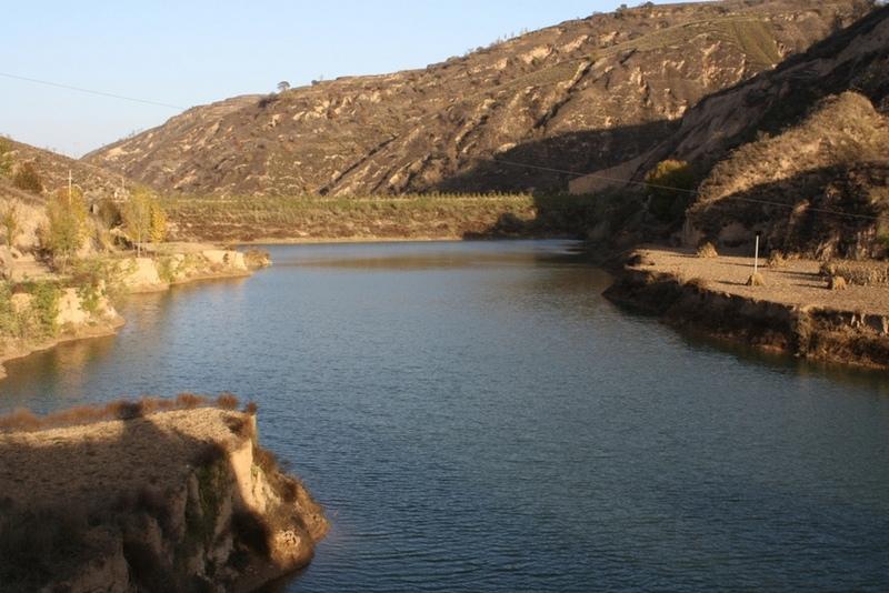
The check dam is a small dam designed to reduce flow velocity, control soil erosion, and allow to settle on the bed of the valley. The whole system includes main body of dam, spillway, overflow and supporting measures. The check dam for land is a small dam mainly for land after it is filled up by the sediment from upstream area, from several years to 20 years in common, it could be flat land in the valley, not mainly for water collection (different from reservior).
Purpose of the Technology: Check dams in the Loess Plateau are very common. There are many advantages. The check dam could not only reduce the erosion of the gullies, furthermore it retain the sediment in the flow and this decreases the sediment of the Yellow River. The check dam is good quality land for the soils because of the sedimentation of organic matter and other nutrients from topsoil . In this region soils are deep and very fertile because most soil is from the top soil upstream. The soil moisture of check dam is also much better than in any other places in the watershed because the flood should go away from its surface and the water inflitration is great in raining seasons.
Establishment / maintenance activities and inputs: The establishment needs enough money because it has to be safe enough, and the maintenance cost is not so high. The catchment with great soil erosion is better when we considered the formation time of land.
Natural / human environment: The controlling area of check dam for land varies greatly from 30 square km or more. Since the "Grain for Green" Project of China in 1999, the soil erosion on the slope decreased. The time from reservoir to land need more time because there is less and less sediment from upstream and the sedimentation changed slowly.
2.3 รูปภาพของเทคโนโลยี
อัลบั้มสื่อบันทึก
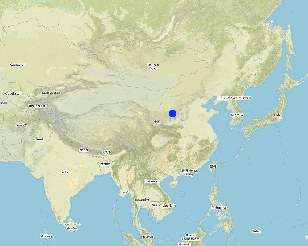
2.5 ประเทศภูมิภาค หรือสถานที่ตั้งที่เทคโนโลยีได้นำไปใช้และได้รับการครอบคลุมโดยการประเมินนี้
ประเทศ:
จีน
ภูมิภาค/รัฐ/จังหวัด:
Shaanxi Province
ข้อมูลจำเพาะเพิ่มเติมของสถานที่ตั้ง :
Yanhe River Basin
ระบุการกระจายตัวของเทคโนโลยี:
- ใช้ ณ จุดที่เฉพาะเจาะจงหรือเน้นไปยังบริเวณพื้นที่ขนาดเล็ก
แสดงความคิดเห็น:
Boundary points of the Technology area: Only one check-dam for land is listed here.
Total area covered by the SLM Technology is 19.4 km2.
The total area with different measures is almost 2000 km2 . Yanhe River is a first class branch of Yellow River, China. The average channel slope is 3.26‰, and the area of whole basin is 7,687 km2. It is situated in the semi-arid North Temperate Zone with an average annual precipitation varying from 500 to 550 mm, and an average annual air temperature ranging from 8.5 to 11.4℃. It is in hilly gully area of the Loess Plateau covered by loess. The landform is broken seriously. The gully density (the length of channel in one km2) is amount to 2.1 to 4.6 km•km-2. The soil loss is severe all along.
The Ganguyi Hydrology Station (109°48′E, 36°42′N) located in the Ganguyi Town, Baota Country, Yan’an City, Shaanxi Province. The area up Ganguyi Hydrology Station is 5,891 km2, including of Jingbian County(256km2), Zhidan County(708km2), Ansai County(2,699km2) and Baota County(2,228km2). The average annual runoff is 0.22 billion m3, and the runoff modulus accounting for 4,776.36 m3•km-2•yr-1. The average annual sediment flow is 4.776 million tons, and the sediment flow modulus accounting for 8,100 t•km-2•yr-1. The coarse sediment (sediment particle diameter not less than 0.05 mm) flow modulus is 2,430 t•km-2•yr-1 on the Ganguyi Hydrology Station.
Map
×2.6 วันที่การดำเนินการ
ถ้าไม่รู้ปีที่แน่นอน ให้ระบุวันที่โดยประมาณ:
- 10-50 ปี
2.7 คำแนะนำของเทคโนโลยี
ให้ระบุว่าเทคโนโลยีถูกแนะนำเข้ามาอย่างไร:
- ในช่วงการทดลองหรือการทำวิจัย
ความคิดเห็น (ประเภทของโครงการ เป็นต้น) :
It is an old methodology in the Loess Plateau. Since 2003, the check dam had been determined as "Highlight Project " of the Ministry of Water Resources in order to expand in the whole area of the Yellow River Basin.
3. การจัดประเภทของเทคโนโลยี SLM
3.1 วัตถุประสงค์หลักของเทคโนโลยี
- ลด ป้องกัน ฟื้นฟู การเสื่อมโทรมของที่ดิน
3.2 ประเภทของการใช้ที่ดินในปัจจุบันที่ได้นำเทคโนโลยีไปใช้
Land use mixed within the same land unit:
ใช่
Specify mixed land use (crops/ grazing/ trees):
- การปลูกพืชร่วมกับปศุสัตว์และการทำป่าไม้ (Agro-silvopastoralism)

พื้นที่ปลูกพืช
- การปลูกพืชล้มลุกอายุปีเดียว
- การปลูกไม้ยืนต้น ไม้พุ่ม
Annual cropping - Specify crops:
- cereals - maize
- cereals - millet
- flower crops
- fodder crops - alfalfa
- legumes and pulses - beans
- oilseed crops - sunflower, rapeseed, other
- root/tuber crops - potatoes
- buckwheat
Tree and shrub cropping - Specify crops:
- dates
- pome fruits (apples, pears, quinces, etc.)
ระบุ:
Longest growing period in days: 300Longest growing period from month to month: March to NovemberSecond longest growing period in days: 200Second longest growing period from month to month: April to October

ทางน้ำ แหล่งน้ำ พื้นที่ชุ่มน้ำ
- บ่อน้ำ เขื่อน
แสดงความคิดเห็น:
major crop: beans, sunflower, apple, Chinese date, alfalfa, potato, millets, maize, buckwheat
Major land use problems (compiler’s opinion): Normally, the bed of valley is V-shaped and is covered by grass and trees. For the seasonal torrent or flash, it is very difficult to plant crops. The gully also cuts down by runoff and extends because of erosion's gravity .
Major land use problems (land users’ perception): It can not be used as agricultural purpose, especially to get more food.
Future (final) land use (after implementation of SLM Technology): Cropland: Ca: Annual cropping
Livestock is grazing on crop residues
3.3 Has land use changed due to the implementation of the Technology?
Has land use changed due to the implementation of the Technology?
- Yes (Please fill out the questions below with regard to the land use before implementation of the Technology)
พื้นที่ปลูกพืช
- การปลูกพืชล้มลุกอายุปีเดียว
3.4 การใช้น้ำ
การใช้น้ำของที่ดินที่มีการใช้เทคโนโลยีอยู่:
- จากน้ำฝน
3.5 กลุ่ม SLM ที่ตรงกับเทคโนโลยีนี้
- มาตรการปลูกพืชขวางความลาดชัน (cross-slope measure)
- การจัดการน้ำผิวดิน (น้ำพุ แม่น้ำทะเลสาบ ทะเล)
3.6 มาตรการ SLM ที่ประกอบกันเป็นเทคโนโลยี

มาตรการอนุรักษ์ด้วยโครงสร้าง
- S5: เขื่อน ชั้นดินที่แน่นแข็งบ่อน้ำ
- S11: อื่น ๆ
แสดงความคิดเห็น:
Main measures: structural measures
3.7 รูปแบบหลักของการเสื่อมโทรมของที่ดินที่ได้รับการแก้ไขโดยเทคโนโลยี

การกัดกร่อนของดินโดยน้ำ
- Wg (Gully erosion): การกัดกร่อนแบบร่องธารหรือการทำให้เกิดร่องน้ำเซาะ
- Wo (Offsite degradation): ผลกระทบนอกพื้นที่
แสดงความคิดเห็น:
Main type of degradation addressed: Wg: gully erosion / gullying
Secondary types of degradation addressed: Wo: offsite degradation effects
Secondary causes of degradation: Heavy / extreme rainfall (intensity/amounts) (It is the reason of erosion that influence the valley.)
3.8 การป้องกัน การลดลง หรือการฟื้นฟูความเสื่อมโทรมของที่ดิน
ระบุเป้าหมายของเทคโนโลยีกับความเสื่อมโทรมของที่ดิน:
- ป้องกันความเสื่อมโทรมของที่ดิน
- ลดความเสื่อมโทรมของดิน
แสดงความคิดเห็น:
Main goals: prevention of land degradation
Secondary goals: mitigation / reduction of land degradation
4. ข้อมูลจำเพาะด้านเทคนิค กิจกรรมการนำไปปฏิบัติใช้ ปัจจัยนำเข้า และค่าใช้จ่าย
4.1 แบบแปลนทางเทคนิคของเทคโนโลยี
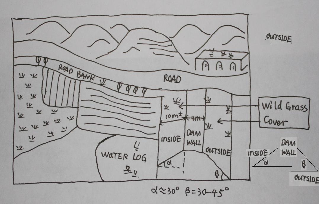
ข้อมูลจำเพาะด้านเทคนิค (แบบแปลนทางเทคนิคของเทคโนโลยี):
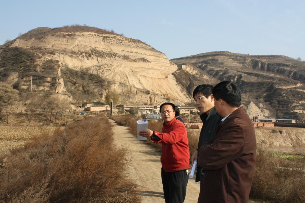
The check dam land.
Location: Mazhuang Watershed. Baota County, Yan'an City, Shaanxi China
Date: 2008-10-20
Technical knowledge required for field staff / advisors: high (The design and construction need professional knowledge.)
Technical knowledge required for land users: low (it is easy to use, like alluvial land or wide terrace.)
Main technical functions: control of concentrated runoff: retain / trap
Spillway
Vertical interval between structures (m): 3
Spacing between structures (m): 6
Height of bunds/banks/others (m): 4
Width of bunds/banks/others (m): 6
Length of bunds/banks/others (m): 100
Dam/ pan/ pond
Vertical interval between structures (m): 10
Spacing between structures (m): 100
Depth of ditches/pits/dams (m): 10
Width of ditches/pits/dams (m): 50-100
Length of ditches/pits/dams (m): 300-1000
Construction material (earth): The earth-bank dam is built in Yanhe River Basin.
Construction material (stone): to build the spillways
Slope (which determines the spacing indicated above): 2-5%
If the original slope has changed as a result of the Technology, the slope today is: 2%
Lateral gradient along the structure: 2%
Specification of dams/ pans/ ponds: Capacity 180000m3
Catchment area: 58.3km2m2
Slope of dam wall inside: 30%;
Slope of dam wall outside: 60%
Dimensions of spillways: 3m
Vegetation is used for stabilisation of structures.
ผู้เขียน:
Wang Fei, Yangling, Shaanxi Province, China
4.2 ข้อมูลทั่วไปเกี่ยวกับการคำนวณปัจจัยนำเข้าและค่าใช้จ่าย
ระบุสกุลเงินที่ใช้คำนวณค่าใช้จ่าย:
- USD
If relevant, indicate exchange rate from USD to local currency (e.g. 1 USD = 79.9 Brazilian Real): 1 USD =:
-2.17
ระบุค่าเฉลี่ยของค่าจ้างในการจ้างแรงงานต่อวัน:
8.80
4.3 กิจกรรมเพื่อการจัดตั้ง
| กิจกรรม | Timing (season) | |
|---|---|---|
| 1. | Field survey and location selection | Before design |
| 2. | Design | before construction |
| 3. | Build the dam wall | |
| 4. | Check and accept | After the construction |
4.4 ค่าใช้จ่ายของปัจจัยนำเข้าที่จำเป็นสำหรับการจัดตั้ง
| ปัจจัยนำเข้า | หน่วย | ปริมาณ | ค่าใช้จ่ายต่อหน่วย | ค่าใช้จ่ายทั้งหมดต่อปัจจัยนำเข้า | %ของค่าใช้จ่ายที่ก่อให้เกิดขึ้นโดยผู้ใช้ที่ดิน | |
|---|---|---|---|---|---|---|
| แรงงาน | Building the wall/ field survey and planning | Person/day | 180.0 | 8.8 | 1584.0 | 90.0 |
| แรงงาน | Building the wall/ field survey | Machine/hrs | 75.0 | 43.8 | 3285.0 | |
| วัสดุสำหรับก่อสร้าง | Stone | m^3 | 40.0 | 26.35 | 1054.0 | |
| ค่าใช้จ่ายทั้งหมดของการจัดตั้งเทคโนโลยี | 5923.0 | |||||
| Total costs for establishment of the Technology in USD | -2729.49 | |||||
แสดงความคิดเห็น:
Duration of establishment phase: 1 month(s)
4.5 การบำรุงรักษาสภาพหรือกิจกรรมที่เกิดขึ้นเป็นประจำ
| กิจกรรม | ช่วงระยะเวลา/ความถี่ | |
|---|---|---|
| 1. | check the dam wall | annually |
4.6 ค่าใช้จ่ายของปัจจัยนำเข้าและกิจกรรมที่เกิดขึ้นเป็นประจำที่ต้องการการบำรุงรักษา (ต่อปี)
| ปัจจัยนำเข้า | หน่วย | ปริมาณ | ค่าใช้จ่ายต่อหน่วย | ค่าใช้จ่ายทั้งหมดต่อปัจจัยนำเข้า | %ของค่าใช้จ่ายที่ก่อให้เกิดขึ้นโดยผู้ใช้ที่ดิน | |
|---|---|---|---|---|---|---|
| แรงงาน | check annualy the dam wall | Person/day | 15.0 | 8.8 | 132.0 | |
| ค่าใช้จ่ายทั้งหมดของการบำรุงรักษาสภาพเทคโนโลยี | 132.0 | |||||
| Total costs for maintenance of the Technology in USD | -60.83 | |||||
แสดงความคิดเห็น:
Machinery/ tools: crawler type bulldozer, giant jet, tractor, traditional tools, ruler,
The grass on both sides of check wall is natural grass.
4.7 ปัจจัยสำคัญที่สุดที่มีผลกระทบต่อค่าใช้จ่าย
ปัจจัยสำคัญที่สุดที่มีผลกระทบต่อค่าใช้จ่ายต่างๆ:
The wide of dam wall affects the cost greatly, the wider, more expensive.The labour cost and the distance of rock quarry are also important.
5. สิ่งแวดล้อมทางธรรมชาติและของมนุษย์
5.1 ภูมิอากาศ
ฝนประจำปี
- < 250 ม.ม.
- 251-500 ม.ม.
- 501-750 ม.ม.
- 751-1,000 ม.ม.
- 1,001-1,500 ม.ม.
- 1,501-2,000 ม.ม.
- 2,001-3,000 ม.ม.
- 3,001-4,000 ม.ม.
- > 4,000 ม.ม.
ข้อมูลจำเพาะ/ความคิดเห็นเรื่องปริมาณน้ำฝน:
The mean annual rainfall in the basin is 515.2 mm in the duration from 1952 to 2000. The rainfall from May to Oct accounts for 446.8 mm, up to 86.7%; and that from Jun to Sep accounts for 367.6 mm, up
เขตภูมิอากาศเกษตร
- กึ่งแห้งแล้ง
Thermal climate class: temperate. The accumulating time that temperature above 0 ℃ about 3800 hours, and that above 10 ℃ is more than 3200 hours
It is based on the classification sysytem only based on the rainfall.
5.2 สภาพภูมิประเทศ
ค่าเฉลี่ยความลาดชัน:
- ราบเรียบ (0-2%)
- ลาดที่ไม่ชัน (3-5%)
- ปานกลาง (6-10%)
- เป็นลูกคลื่น (11-15%)
- เป็นเนิน (16-30%)
- ชัน (31-60%)
- ชันมาก (>60%)
ธรณีสัณฐาน:
- ที่ราบสูง/ที่ราบ
- สันเขา
- ไหล่เขา
- ไหล่เนินเขา
- ตีนเนิน
- หุบเขา
ระดับความสูง:
- 0-100 เมตร
- 101-500 เมตร
- 501-1,000 เมตร
- 1,001-1,500 เมตร
- 1,501-2,000 เมตร
- 2,001-2,500 เมตร
- 2,501-3,000 เมตร
- 3,001-4,000 เมตร
- > 4,000 เมตร
ให้ระบุถ้าเทคโนโลยีได้ถูกนำไปใช้:
- บริเวณแอ่งบนที่ราบ (concave situations)
ความคิดเห็นและข้อมูลจำเพาะเพิ่มเติมเรื่องสภาพภูมิประเทศ:
Altitudinal zone: All check dam and check dam liand here is in such altitudinal zonation.
Slopes on average: Based on 1:100 thousand scale landform map
5.3 ดิน
ค่าเฉลี่ยความลึกของดิน:
- ตื้นมาก (0-20 ซ.ม.)
- ตื้น (21-50 ซ.ม.)
- ลึกปานกลาง (51-80 ซ.ม.)
- ลึก (81-120 ซ.ม.)
- ลึกมาก (>120 ซ.ม.)
เนื้อดิน (ดินชั้นบน):
- ปานกลาง (ดินร่วน ทรายแป้ง)
อินทรียวัตถุในดิน:
- ต่ำ (<1%)
(ถ้ามี) ให้แนบคำอธิบายเรื่องดินแบบเต็มหรือระบุข้อมูลที่มีอยู่ เช่น ชนิดของดิน ค่า pH ของดินหรือความเป็นกรดของดิน ความสามารถในการแลกเปลี่ยนประจุบวก ไนโตรเจน ความเค็ม เป็นต้น:
Soil depth on average: The depth of Loess varies from nearly 30 m to more than 100 m in Yanhe River Basin. The depth of soil is less than this but it could be nearly 10 meters in commom.
Soil texture: There are more than 50% soil particle which are fine sand with size between 0.05 and 0.1 mm
Soil fertility very low: Lack of N, P and SOM
Topsoil organic matter: <0.5%
Soil drainage / infiltration good: The inflitration in Loess is very fast, but it prones to sealing when flashing
Soil water storage capacity low: Evaporation and drainage are easy
5.4 ความเป็นประโยชน์และคุณภาพของน้ำ
ระดับน้ำใต้ดิน:
5-50 เมตร
น้ำไหลบ่าที่ผิวดิน:
ปานกลาง
คุณภาพน้ำ (ที่ยังไม่ได้บำบัด):
เป็นน้ำเพื่อการดื่มที่ไม่ดี (จำเป็นต้องได้รับการบำบัด)
ความคิดเห็นและข้อมูลจำเพาะเพิ่มเติมเรื่องคุณภาพและปริมาณน้ำ:
Availability of surface water also poor/ none and: Nearly all the branches of Yanhe are seasonal rivers
Availability of surface water medium: It is very stable in this region
Water quality (untreated): Good quality for there are few pollution sources
5.5 ความหลากหลายทางชีวภาพ
ความหลากหลายทางชนิดพันธุ์:
- ปานกลาง
ความคิดเห็นและข้อมูลจำเพาะเพิ่มเติมของความหลากหลายทางชีวภาพ:
It is very stable in this region
5.6 ลักษณะของผู้ใช้ที่ดินที่นำเทคโนโลยีไปปฏิบัติใช้
แนวทางการตลาดของระบบการผลิต:
- mixed (subsistence/ commercial)
- ทำการค้า/การตลาด
รายได้ที่มาจากนอกฟาร์ม:
- 10-50% ของรายได้ทั้งหมด
ระดับของความมั่งคั่งโดยเปรียบเทียบ:
- พอมีพอกิน
เป็นรายบุคคล/ครัวเรือน:
- กลุ่ม/ชุมชน
ระดับของการใช้เครื่องจักรกล:
- การใช้กำลังจากสัตว์
- การใช้เครื่องจักรหรือเครื่องยนต์
เพศ:
- หญิง
- ชาย
ระบุลักษณะอื่นๆที่เกี่ยวข้องของผู้ใช้ที่ดิน:
Land users applying the Technology are mainly Leaders / privileged
Difference in the involvement of women and men: No clear difference
Population density: 50-100 persons/km2
Annual population growth: < 0.5%
(The Check dam for land are build together in some villages for all the people funded by national sub).
Level of mechanization also manual work: The harvesting and other management are by hand
Level of mechanization animal traction: Tillage with animal power mostly
Level of mechanization mechanized/motorized: Tillage with machine in large area check-dam land.
Market orientation of production system mixed: Some production for themselves, but most of production is exchanged on the market.
5.7 Average area of land used by land users applying the Technology
- < 0.5 เฮกตาร์
- 0.5-1 เฮกตาร์
- 1-2 เฮกตาร์
- 2-5 เฮกตาร์
- 5-15 เฮกตาร์
- 15-50 เฮกตาร์
- 50-100 เฮกตาร์
- 100-500 เฮกตาร์
- 500-1,000 เฮกตาร์
- 1,000-10,000 เฮกตาร์
- >10,000 เฮกตาร์
พิจารณาว่าเป็นขนาดเล็ก กลาง หรือขนาดใหญ่ (ซึ่งอ้างอิงถึงบริบทระดับท้องถิ่น):
- ขนาดเล็ก
แสดงความคิดเห็น:
According to 0.054 ha per capita
5.8 กรรมสิทธิ์ในที่ดิน สิทธิในการใช้ที่ดินและสิทธิในการใช้น้ำ
กรรมสิทธิ์ในที่ดิน:
- รัฐ
- เป็นแบบชุมชนหรือหมู่บ้าน
สิทธิในการใช้ที่ดิน:
- รายบุคคล
สิทธิในการใช้น้ำ:
- เข้าถึงได้แบบเปิด (ไม่ได้จัดระเบียบ)
แสดงความคิดเห็น:
Like other rural areas in China
5.9 การเข้าถึงบริการและโครงสร้างพื้นฐาน
สุขภาพ:
- จน
- ปานกลาง
- ดี
การศึกษา:
- จน
- ปานกลาง
- ดี
การจ้างงาน (เช่น ภายนอกฟาร์ม):
- จน
- ปานกลาง
- ดี
ถนนและการขนส่ง:
- จน
- ปานกลาง
- ดี
น้ำดื่มและการสุขาภิบาล:
- จน
- ปานกลาง
- ดี
บริการด้านการเงิน:
- จน
- ปานกลาง
- ดี
6. ผลกระทบและสรุปคำบอกกล่าว
6.1 ผลกระทบในพื้นที่ดำเนินการ (On-site) จากการใช้เทคโนโลยี
ผลกระทบทางด้านเศรษฐกิจและสังคม
การผลิต
การผลิตพืชผล
จำนวนก่อน SLM:
600
หลังจาก SLM:
6000
การเสี่ยงต่อความล้มเหลวในการผลิต
จำนวนก่อน SLM:
4500kg/ha
หลังจาก SLM:
2500kg/ha
แสดงความคิดเห็น/ระบุ:
In extreme year with great rainfall, low yield of check dam land
ความหลากหลายของผลิตภัณฑ์
พื้นที่สำหรับการผลิต
จำนวนก่อน SLM:
950
หลังจาก SLM:
59
ผลกระทบด้านสังคมวัฒนธรรมอื่น ๆ
สถาบันแห่งชาติ
สถานการณ์ของกลุ่มด้อยโอกาส ทางด้านสังคมและเศรษฐกิจ
จำนวนก่อน SLM:
200 kg
หลังจาก SLM:
350 kg
Livelihoods and human well-being
ผลกระทบด้านนิเวศวิทยา
วัฐจักรน้ำหรือน้ำบ่า
การระบายน้ำส่วนเกิน
น้ำบาดาลหรือระดับน้ำในแอ่งน้ำบาดาล
จำนวนก่อน SLM:
8 m
หลังจาก SLM:
4-6m
ดิน
ความชื้นในดิน
จำนวนก่อน SLM:
12-16%
หลังจาก SLM:
16-22%
การสูญเสียดิน
จำนวนก่อน SLM:
60t/ha/yr
หลังจาก SLM:
5t/ha/yr
ผลกระทบด้านนิเวศวิทยาอื่น ๆ
long time period to form land
แสดงความคิดเห็น/ระบุ:
Sediment from slope decelerate the process of building arable land. In other words the economic function can not appear soon.
6.2 ผลกระทบนอกพื้นที่ดำเนินการ (Off-site) จากการใช้เทคโนโลยี
การไหลของน้ำคงที่และสม่ำเสมอในช่วงฤดูแล้ง
น้ำท่วมพื้นที่ท้ายน้ำ
จำนวนก่อน SLM:
2events/yr
หลังจาก SLM:
nearly no
การเกิดมลพิษในน้ำบาดาลหรือแม่น้ำ
6.3 การเผชิญและความตอบสนองของเทคโนโลยีต่อการเปลี่ยนแปลงสภาพภูมิอากาศที่ค่อยเป็นค่อยไป และสภาพรุนแรงของภูมิอากาศ / ภัยพิบัติ (ที่รับรู้ได้โดยผู้ใช้ที่ดิน)
การเปลี่ยนแปลงสภาพภูมิอากาศที่ค่อยเป็นค่อยไป
การเปลี่ยนแปลงสภาพภูมิอากาศที่ค่อยเป็นค่อยไป
| ฤดู | increase or decrease | เทคโนโลยีมีวิธีการรับมืออย่างไร | |
|---|---|---|---|
| อุณหภูมิประจำปี | เพิ่มขึ้น | ดี |
สภาพรุนแรงของภูมิอากาศ (ภัยพิบัติ)
ภัยพิบัติทางอุตุนิยมวิทยา
| เทคโนโลยีมีวิธีการรับมืออย่างไร | |
|---|---|
| พายุฝนประจำท้องถิ่น | ดี |
| พายุลมประจำท้องถิ่น | ดี |
ภัยพิบัติจากสภาพภูมิอากาศ
| เทคโนโลยีมีวิธีการรับมืออย่างไร | |
|---|---|
| ภัยจากฝนแล้ง | ดี |
ภัยพิบัติจากน้ำ
| เทคโนโลยีมีวิธีการรับมืออย่างไร | |
|---|---|
| น้ำท่วมตามปกติ (แม่น้ำ) | ดี |
ผลลัพธ์ตามมาที่เกี่ยวข้องกับภูมิอากาศอื่น ๆ
ผลลัพธ์ตามมาที่เกี่ยวข้องกับภูมิอากาศอื่น ๆ
| เทคโนโลยีมีวิธีการรับมืออย่างไร | |
|---|---|
| ช่วงการปลูกพืชที่ลดลงมา | ไม่ทราบ |
แสดงความคิดเห็น:
The better condition of soil and water of check dam land improves the capacity of land tp cope with the changing climate.
6.4 การวิเคราะห์ค่าใช้จ่ายและผลประโยชน์ที่ได้รับ
ผลประโยชน์ที่ได้รับเปรียบเทียบกับค่าใช้จ่ายในการจัดตั้งเป็นอย่างไร (จากมุมมองของผู้ใช้ที่ดิน)
ผลตอบแทนระยะสั้น:
ด้านลบเล็กน้อย
ผลตอบแทนระยะยาว:
ด้านบวก
ผลประโยชน์ที่ได้รับเปรียบเทียบกับค่าใช้จ่ายในการบำรุงรักษาหรือต้นทุนที่เกิดขึ้นซ้ำอีก เป็นอย่างไร (จากมุมมองของผู้ใช้ที่ดิน)
ผลตอบแทนระยะสั้น:
ด้านบวก
ผลตอบแทนระยะยาว:
ด้านบวก
แสดงความคิดเห็น:
In the first stage, there is no economic output but the check dam is going to fill up with sediments. Afterwards the check dam forms land and with it benefit which would keep up a long time.
6.5 การปรับตัวของเทคโนโลยี
- 11-50%
ถ้ามีข้อมูลให้บอกปริมาณด้วย (จำนวนของครัวเรือนหรือครอบคลุมพื้นที่):
675 households in an area of 19.4 km^2 (11 percent of the area)
Of all those who have adopted the Technology, how many did so spontaneously, i.e. without receiving any material incentives/ payments?
- 0-10%
แสดงความคิดเห็น:
100% of land user families have adopted the Technology with external material support
675 land user families have adopted the Technology with external material support
Comments on acceptance with external material support: All the lands (cropland on the slope or check dam land and forest et al, ) are shared evenly by people. Of course, the work like to build check dam should be finished by all the families.
Comments on spontaneous adoption: No single farmer or family can finish this work because the land right and great investment.
There is a strong trend towards spontaneous adoption of the Technology
Comments on adoption trend: More and more local farmers want to get more check dam land for its long-term benefits.
6.7 จุดแข็ง / ข้อได้เปรียบ / โอกาสของเทคโนโลยี
| จุดแข็ง / ข้อได้เปรียบ / โอกาสในทัศนคติของผู้ใช้ที่ดิน |
|---|
|
The yield of check dam land is much higher than that on the slope land. How can they be sustained / enhanced? Ask the local people to do more work without payment because they would get more benefits from this land as such. |
|
The yield is stable because the soil moisture is good even in dry year How can they be sustained / enhanced? Use the land efficient and mainten it. |
| จุดแข็ง / ข้อได้เปรียบ / โอกาสในทัศนคติของผู้รวบรวมหรือวิทยากรหลัก |
|---|
|
It could reduce the soil erosion originated from the gully. How can they be sustained / enhanced? The local people know this benefit that make them try to find chance to build check dam. |
|
The dam can retain the flow and sediment and reduces the sediment delivery of the downstream. How can they be sustained / enhanced? Ask the people or government of the lower reaches to combat soil erosion through the building of check dams. |
|
The check dam land is fertile and productive How can they be sustained / enhanced? When we make the plan or design the construction, we should better take this into account. |
|
Land is fertile and productive How can they be sustained / enhanced? Improve the awareness of local people to use this technology. |
|
The ceck dam can be used as rural road. How can they be sustained / enhanced? When we make the plan or design the construction, we should better take this into account. |
6.8 จุดอ่อน / ข้อเสียเปรียบ / ความเสี่ยงของเทคโนโลยีและวิธีการแก้ไข
| จุดอ่อน / ข้อเสียเปรียบ / ความเสี่ยงในทัศนคติของผู้ใช้ที่ดิน | มีวิธีการแก้ไขได้อย่างไร |
|---|---|
| It is too expensive to build the check dam. | Ask the government or other organization and person to invest in check dams.The local people can work together without payment. |
| จุดอ่อน / ข้อเสียเปรียบ / ความเสี่ยงในทัศนคติของผู้รวบรวมหรือวิทยากรหลัก | มีวิธีการแก้ไขได้อย่างไร |
|---|---|
| The land in a check dam with less and less soil erosion on the slope, needs longer time to form | It is difficult to overcome this because the control of erosion on slope has higher priority. We can find how to use the water or the temporary wetland. |
| The input of check dam is quite high. | Ask the government or other organization and person to invest in check dams. The local people can work together without payment. |
7. การอ้างอิงและการเชื่อมต่อ
7.1 วิธีการและแหล่งข้อมูล
7.2 การอ้างอิงถึงสิ่งตีพิมพ์
หัวข้อ, ผู้เขียน, ปี, หมายเลข ISBN:
Soil and water conservation records of Shaanxi Province. 2000. Shaanxi People's Press, Xi'an City, China
ชื่อเรื่อง ผู้เขียน ปี ISBN:
Library of ISWC, CAS
ลิงก์และโมดูล
ขยายทั้งหมด ย่อทั้งหมดลิงก์
Project of check-dam for land [จีน]
Approach of check dam for land is a kind of soil and water conservation activity to reduce the sediment discharge and improve the agricultural condition through building a dam across the valley in order to silt the sediment from upstream untill it convert to land with few soil erosion and …
- ผู้รวบรวม: Fei WANG
โมดูล
ไม่มีโมดูล