Village irrigation schemes developed using the PMN/IPRODI approach [มาลี]
- ผู้สร้างสรรค์:
- การอัพเดท:
- ผู้รวบรวม: Dieter Nill
- ผู้เรียบเรียง: –
- ผู้ตรวจสอบ: Deborah Niggli, Alexandra Gavilano
Périmètres irrigués villageois type PMN/IPRODI (French)
technologies_1630 - มาลี
ดูส่วนย่อย
ขยายทั้งหมด ย่อทั้งหมด1. ข้อมูลทั่วไป
1.2 รายละเอียดที่ติดต่อได้ของผู้รวบรวมและองค์กรที่เกี่ยวข้องในการประเมินและการจัดเตรียมทำเอกสารของเทคโนโลยี
ผู้เชี่ยวชาญ SLM:
Ali Yehia Ag Mohamed
PMN/IPRODI
มาลี
ผู้เชี่ยวชาญ SLM:
Kliewe Matthias
PMN/IPRODI
มาลี
ชื่อของโครงการซึ่งอำนวยความสะดวกในการทำเอกสารหรือการประเมินเทคโนโลยี (ถ้าเกี่ยวข้อง)
Manual of Good Practices in Small Scale Irrigation in the Sahel (GIZ )ชื่อขององค์กรซึ่งอำนวยความสะดวกในการทำเอกสารหรือการประเมินเทคโนโลยี (ถ้าเกี่ยวข้อง)
Deutsche Gesellschaft für Internationale Zusammenarbeit (GIZ) - เยอรมนี1.3 เงื่อนไขการใช้ข้อมูลที่ได้บันทึกผ่านทาง WOCAT
ผู้รวบรวมและวิทยากรหลักยอมรับเงื่อนไขเกี่ยวกับการใช้ข้อมูลที่ถูกบันทึกผ่านทาง WOCAT:
ใช่
1.4 การเปิดเผยเรื่องความยั่งยืนของเทคโนโลยีที่ได้อธิบายไว้
เทคโนโลยีที่ได้อธิบายไว้นี้เป็นปัญหาของความเสื่อมโทรมโทรมของที่ดินหรือไม่ จึงไม่ได้รับการยอมรับว่าเป็นเทคโนโลยีเพื่อการจัดการที่ดินอย่างยั่งยืน:
ไม่ใช่
1.5 Reference to Questionnaire(s) on SLM Approaches (documented using WOCAT)

Participatory approach to small-scale irrigation [มาลี]
The participatory approach to small-scale irrigation ensures skills and expertise are transferred to scheme beneficiaries and other stakeholders.
- ผู้รวบรวม: Dieter Nill
2. การอธิบายลักษณะของเทคโนโลยี SLM
2.1 การอธิบายแบบสั้น ๆ ของเทคโนโลยี
คำจำกัดความของเทคโนโลยี:
Village irrigation schemes (VISs) help to control the water supply and significantly increase yields.
2.2 การอธิบายแบบละเอียดของเทคโนโลยี
คำอธิบาย:
Village irrigation schemes (VISs) are a concept and a development typology created in the 1970s and 80s. Using a relatively simple development concept, it was possible to create production units that were built and managed by local people in areas seriously affected by drought and a sharp decline in inundation events in the 1970s and 80s. Instead of being dependent on food aid, local people operating a VIS were able to guarantee sufficient rice production to cover their village’s food needs. With one pumping facility and one canal network installed, it is possible to control the water supply for an area of at least 20 hectares, thus creating the required conditions for intensive rice growing.
Prior to the installation of the scheme, the sites are not suitable for rice growing. Yields significantly increase as a result of the work carried out. An average harvest of six tonnes per hectare increases incomes. With an average price of 125 CFA francs per kilo of paddy, the rate of sales reaches 750,000 CFA francs per hectare. The surplus per hectare is estimated at 300,000 CFA francs.
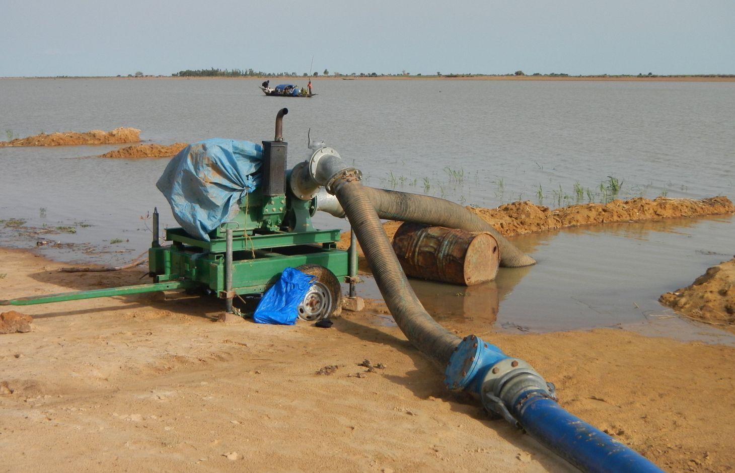
A VIS comprises a pumping station, small-scale facilities infrastructure, and irrigation and drainage networks. The pumping station consists of a pump unit fitted with a diesel motor with two or three 28 to 38 horse-power cylinders and a centrifugal pump with a capacity of 350 to 480 cubic metres per hour. The pump is positioned right alongside the water source (river, lake) and is mounted on a mobile chassis so it can be repositioned as and when required
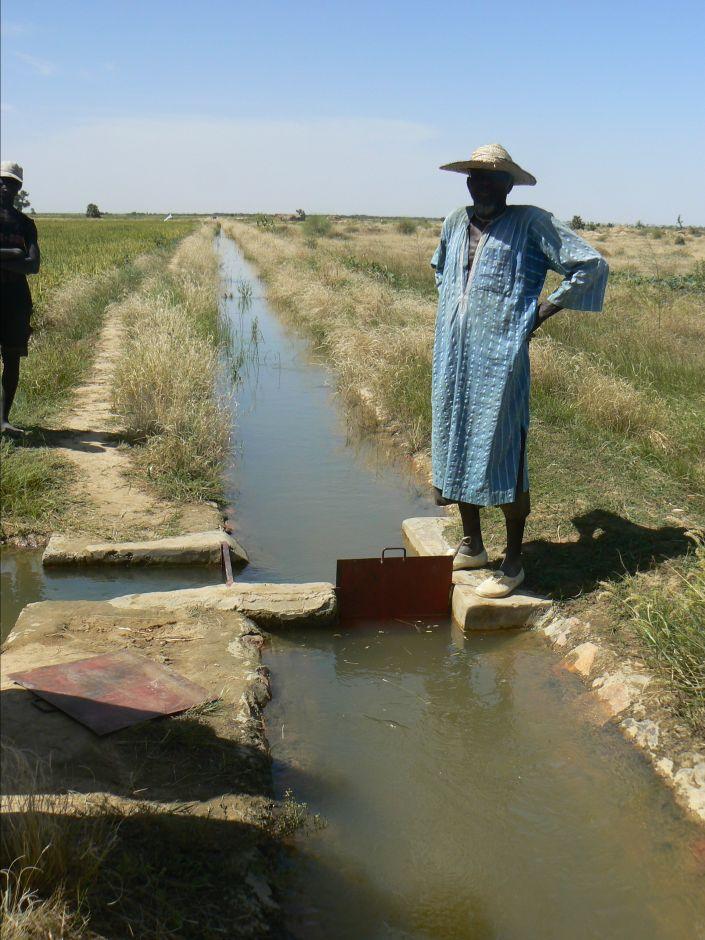
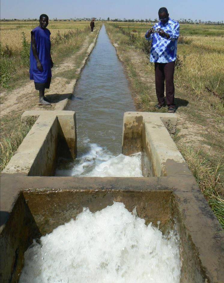
and depending on the situation of the water source, which can vary considerably during the winter growing season. At the end of the growing season, the pump unit can be stored in a secure, weather-proof location (out of the sun, rain, etc.). Water is then pumped through a flexible hose of reinforced polyethylene (the lengths generally being multiples of 50 metres, but no longer than 150 metres) up into the delivery basin where the energy carried in the turbulent pumped water is dissipated to prevent erosion damage and where the flow is calmed from turbulent to laminar. From the delivery basin onwards, the system makes use of gravity to feed its open canal network. The majority of the network is comprised of earthen structures, with only a section of the main canal being lined (usually a length of between 150 to 300 metres leading from the delivery basin outflow). The secondary and/or tertiary canals are supplied with water through a division box that apportions supply using a system of (‘all or nothing’) gates. Plots are watered from the tertiary canal by turning on the PVC hose.
Initially, villagers are able to express their need for a VIS through a village diagnostic exercise. This installation request is then taken up by the communes’ PDESC. A formal request is then referred to the mayor and drawn up by the community. The support structure (PMN/IPRODI) reviews the request and carries out a preliminary feasibility study. Decisions are then taken in a planning workshop on which schemes to prioritise. Following this, private planning consultants are commissioned to conduct feasibility studies. In parallel, technical and financial analyses are carried out by the programme’s planners, who also validate the studies. A meeting is held to inform and raise the awareness of the beneficiary communities about the development approach. The community is then requested to contribute their labour as part of the HLIW measures. The financial contribution required for the pump unit is up to 30% of its cost.
Farming a VIS (intensive rice growing) is fundamentally different to other, more traditional production systems to which farmers are accustomed (extensive rice growing in floodplains and millet growing in non-flooded areas). VISs require the purchase of inputs and the sale of at least part of the produce. Farming a VIS requires the development and good functioning of a value chain with many more links upstream and downstream of production and beyond the confines of the village than would be found in a traditional system. Although the VIS was initially conceived as a drought response mechanism in the 1970 and 80s, VIS farming encourages farmers to become more integrated in the rural and regional economy.
2.3 รูปภาพของเทคโนโลยี
อัลบั้มสื่อบันทึก
2.5 ประเทศภูมิภาค หรือสถานที่ตั้งที่เทคโนโลยีได้นำไปใช้และได้รับการครอบคลุมโดยการประเมินนี้
ประเทศ:
มาลี
ภูมิภาค/รัฐ/จังหวัด:
Mali
ข้อมูลจำเพาะเพิ่มเติมของสถานที่ตั้ง :
Mopti, Timbuktu
แสดงความคิดเห็น:
Total area covered by the SLM Technology is 0.4 km2.
Five communes in the Mopti region and 38 communes in the Timbuktu region.
Installation of 489 VISs in at least 43 communes. Farmable land: 16,832 hectares. Approximate number of beneficiaries: 335,200 People.
The area of schemes developed by PMN/IPRODI ranges from 30 to 40 hectares. Initially, the programme installed 30-hectare schemes supplied with two-cylinder pump units. Since 2004, it has only developed 40-hectare schemes supplied with three-cylinder pump units. All the schemes are divided up into 0.25-hectare plots, making a total of 160 plots. The maximum distance from the sprinkler to the drain on the other side is 100 metres.
2.6 วันที่การดำเนินการ
ถ้าไม่รู้ปีที่แน่นอน ให้ระบุวันที่โดยประมาณ:
- 10-50 ปี
2.7 คำแนะนำของเทคโนโลยี
ให้ระบุว่าเทคโนโลยีถูกแนะนำเข้ามาอย่างไร:
- ทางโครงการหรือจากภายนอก
ความคิดเห็น (ประเภทของโครงการ เป็นต้น) :
Since 1997, by PMN/IPRODI
3. การจัดประเภทของเทคโนโลยี SLM
3.1 วัตถุประสงค์หลักของเทคโนโลยี
- ปรับปรุงการผลิตให้ดีขึ้น
- อนุรักษ์ระบบนิเวศน์
3.2 ประเภทของการใช้ที่ดินในปัจจุบันที่ได้นำเทคโนโลยีไปใช้
Land use mixed within the same land unit:
ใช่
Specify mixed land use (crops/ grazing/ trees):
- Agro-pastoralism (incl. integrated crop-livestock)

พื้นที่ปลูกพืช
- การปลูกพืชล้มลุกอายุปีเดียว
- rice
จำนวนของฤดูเพาะปลูกต่อปี:
- 1
ระบุ:
Longest growing period in days: 120, Longest growing period from month to month: August-November

ทุ่งหญ้าเลี้ยงสัตว์
แสดงความคิดเห็น:
Major land use problems (compiler’s opinion): Prior to the installation of the scheme, the sites are not suitable for rice growing.
Livestock density: 1-10 LU /km2
3.4 การใช้น้ำ
การใช้น้ำของที่ดินที่มีการใช้เทคโนโลยีอยู่:
- น้ำฝนร่วมกับการชลประทาน
3.5 กลุ่ม SLM ที่ตรงกับเทคโนโลยีนี้
- การจัดการด้านชลประทาน (รวมถึงการลำเลียงส่งน้ำ การระบายน้ำ)
- การผันน้ำและการระบายน้ำ
- การจัดการน้ำผิวดิน (น้ำพุ แม่น้ำทะเลสาบ ทะเล)
3.6 มาตรการ SLM ที่ประกอบกันเป็นเทคโนโลยี

มาตรการอนุรักษ์ด้วยการจัดการ
- M7: อื่นๆ
แสดงความคิดเห็น:
Specification of other management measures: irrigation schemes
3.7 รูปแบบหลักของการเสื่อมโทรมของที่ดินที่ได้รับการแก้ไขโดยเทคโนโลยี

การเสื่อมโทรมของน้ำ
- Ha (Aridification): การเกิดความแห้งแล้ง
แสดงความคิดเห็น:
Main causes of degradation: over abstraction / excessive withdrawal of water (for irrigation, industry, etc.)
3.8 การป้องกัน การลดลง หรือการฟื้นฟูความเสื่อมโทรมของที่ดิน
ระบุเป้าหมายของเทคโนโลยีกับความเสื่อมโทรมของที่ดิน:
- ฟื้นฟูบำบัดที่ดินที่เสื่อมโทรมลงอย่างมาก
4. ข้อมูลจำเพาะด้านเทคนิค กิจกรรมการนำไปปฏิบัติใช้ ปัจจัยนำเข้า และค่าใช้จ่าย
4.1 แบบแปลนทางเทคนิคของเทคโนโลยี
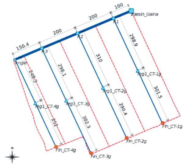
ข้อมูลจำเพาะด้านเทคนิค (แบบแปลนทางเทคนิคของเทคโนโลยี):
Layout plan of the irrigation network (in blue) and the drainage network (in red)
Technical knowledge required for field staff / advisors: high
Technical knowledge required for land users: moderate
Main technical functions: increase / maintain water stored in soil, water harvesting / increase water supply, promotion of vegetation species and varieties (quality, eg palatable fodder)
ผู้เขียน:
PMN/IPRODI
4.2 ข้อมูลทั่วไปเกี่ยวกับการคำนวณปัจจัยนำเข้าและค่าใช้จ่าย
อื่นๆ หรือสกุลเงินประจำชาติ (ระบุ):
CFA Franc
If relevant, indicate exchange rate from USD to local currency (e.g. 1 USD = 79.9 Brazilian Real): 1 USD =:
517.0
4.3 กิจกรรมเพื่อการจัดตั้ง
| กิจกรรม | Timing (season) | |
|---|---|---|
| 1. | formal request for irrigation scheme | |
| 2. | support structure (PMN/IPRODI) reviews the request and carries out a preliminary feasibility study | |
| 3. | Decisions are then taken in a planning workshop on which schemes to prioritise | |
| 4. | private planning consultants are commissioned to conduct feasibility studies | |
| 5. | In parallel, technical and financial analyses are carried out by the programme’s planners | |
| 6. | meeting is held to inform and raise the awareness of the beneficiary communities about the development approach | |
| 7. | community is then requested to contribute their labour |
4.4 ค่าใช้จ่ายของปัจจัยนำเข้าที่จำเป็นสำหรับการจัดตั้ง
| ปัจจัยนำเข้า | หน่วย | ปริมาณ | ค่าใช้จ่ายต่อหน่วย | ค่าใช้จ่ายทั้งหมดต่อปัจจัยนำเข้า | %ของค่าใช้จ่ายที่ก่อให้เกิดขึ้นโดยผู้ใช้ที่ดิน | |
|---|---|---|---|---|---|---|
| อื่น ๆ | total construction | ha | 1.0 | 2497.0 | 2497.0 | 100.0 |
| ค่าใช้จ่ายทั้งหมดของการจัดตั้งเทคโนโลยี | 2497.0 | |||||
| Total costs for establishment of the Technology in USD | 4.83 | |||||
4.5 การบำรุงรักษาสภาพหรือกิจกรรมที่เกิดขึ้นเป็นประจำ
| กิจกรรม | ช่วงระยะเวลา/ความถี่ | |
|---|---|---|
| 1. | Regularly maintaining the facilities and networks | |
| 2. | Agricultural advisory support and monitoring of crops by the technical services |
4.7 ปัจจัยสำคัญที่สุดที่มีผลกระทบต่อค่าใช้จ่าย
ปัจจัยสำคัญที่สุดที่มีผลกระทบต่อค่าใช้จ่ายต่างๆ:
The development costs are estimated at 1.3 million CFA francs per hectare (2,497 Dollar).
On the technical side, numerous scheme configurations have been observed. The most common involves a limited number of small-scale distribution control structures and a network of open, earthen canals. This type of scheme requires an investment in the order of between 1 and 1.5 million CFA francs per hectare. It also fosters the large-scale participation of villagers in all the building works, particularly excavation work and the installation of plots. At the other end of the spectrum are the VISs that have lined canals throughout their entire irrigation network. These require much more substantial investment (up to 7 or 8 million CFA francs per hectare) and building works (including plot installation) are generally carried out by contractors. As yet, no study has indicated that the yields and technical lifespan of such high-cost ‘sophisticated’ schemes are greater than those of ‘basic’ schemes.
5. สิ่งแวดล้อมทางธรรมชาติและของมนุษย์
5.1 ภูมิอากาศ
ฝนประจำปี
- < 250 ม.ม.
- 251-500 ม.ม.
- 501-750 ม.ม.
- 751-1,000 ม.ม.
- 1,001-1,500 ม.ม.
- 1,501-2,000 ม.ม.
- 2,001-3,000 ม.ม.
- 3,001-4,000 ม.ม.
- > 4,000 ม.ม.
เขตภูมิอากาศเกษตร
- กึ่งแห้งแล้ง
Thermal climate class: tropics
5.2 สภาพภูมิประเทศ
ค่าเฉลี่ยความลาดชัน:
- ราบเรียบ (0-2%)
- ลาดที่ไม่ชัน (3-5%)
- ปานกลาง (6-10%)
- เป็นลูกคลื่น (11-15%)
- เป็นเนิน (16-30%)
- ชัน (31-60%)
- ชันมาก (>60%)
ธรณีสัณฐาน:
- ที่ราบสูง/ที่ราบ
- สันเขา
- ไหล่เขา
- ไหล่เนินเขา
- ตีนเนิน
- หุบเขา
ระดับความสูง:
- 0-100 เมตร
- 101-500 เมตร
- 501-1,000 เมตร
- 1,001-1,500 เมตร
- 1,501-2,000 เมตร
- 2,001-2,500 เมตร
- 2,501-3,000 เมตร
- 3,001-4,000 เมตร
- > 4,000 เมตร
5.3 ดิน
ค่าเฉลี่ยความลึกของดิน:
- ตื้นมาก (0-20 ซ.ม.)
- ตื้น (21-50 ซ.ม.)
- ลึกปานกลาง (51-80 ซ.ม.)
- ลึก (81-120 ซ.ม.)
- ลึกมาก (>120 ซ.ม.)
เนื้อดิน (ดินชั้นบน):
- ปานกลาง (ดินร่วน ทรายแป้ง)
- ละเอียด/หนัก (ดินเหนียว)
อินทรียวัตถุในดิน:
- ปานกลาง (1-3%)
- ต่ำ (<1%)
5.4 ความเป็นประโยชน์และคุณภาพของน้ำ
ระดับน้ำใต้ดิน:
5-50 เมตร
น้ำไหลบ่าที่ผิวดิน:
ปานกลาง
คุณภาพน้ำ (ที่ยังไม่ได้บำบัด):
เป็นน้ำใช้เพื่อการเกษตรเท่านั้น (การชลประทาน)
5.5 ความหลากหลายทางชีวภาพ
ความหลากหลายทางชนิดพันธุ์:
- ปานกลาง
5.6 ลักษณะของผู้ใช้ที่ดินที่นำเทคโนโลยีไปปฏิบัติใช้
แนวทางการตลาดของระบบการผลิต:
- mixed (subsistence/ commercial)
รายได้ที่มาจากนอกฟาร์ม:
- 10-50% ของรายได้ทั้งหมด
ระดับของความมั่งคั่งโดยเปรียบเทียบ:
- จน
- พอมีพอกิน
ระดับของการใช้เครื่องจักรกล:
- งานที่ใช้แรงกาย
เพศ:
- ชาย
ระบุลักษณะอื่นๆที่เกี่ยวข้องของผู้ใช้ที่ดิน:
Population density: < 10 persons/km2
Annual population growth: 2% - 3%
10% of the land users are rich.
50% of the land users are average wealthy.
30% of the land users are poor.
10% of the land users are very poor.
5.7 Average area of land used by land users applying the Technology
- < 0.5 เฮกตาร์
- 0.5-1 เฮกตาร์
- 1-2 เฮกตาร์
- 2-5 เฮกตาร์
- 5-15 เฮกตาร์
- 15-50 เฮกตาร์
- 50-100 เฮกตาร์
- 100-500 เฮกตาร์
- 500-1,000 เฮกตาร์
- 1,000-10,000 เฮกตาร์
- >10,000 เฮกตาร์
พิจารณาว่าเป็นขนาดเล็ก กลาง หรือขนาดใหญ่ (ซึ่งอ้างอิงถึงบริบทระดับท้องถิ่น):
- ขนาดเล็ก
5.8 กรรมสิทธิ์ในที่ดิน สิทธิในการใช้ที่ดินและสิทธิในการใช้น้ำ
แสดงความคิดเห็น:
The irrigated land is allocated by the chief
5.9 การเข้าถึงบริการและโครงสร้างพื้นฐาน
สุขภาพ:
- จน
- ปานกลาง
- ดี
การศึกษา:
- จน
- ปานกลาง
- ดี
ความช่วยเหลือทางด้านเทคนิค:
- จน
- ปานกลาง
- ดี
การจ้างงาน (เช่น ภายนอกฟาร์ม):
- จน
- ปานกลาง
- ดี
ตลาด:
- จน
- ปานกลาง
- ดี
พลังงาน:
- จน
- ปานกลาง
- ดี
ถนนและการขนส่ง:
- จน
- ปานกลาง
- ดี
น้ำดื่มและการสุขาภิบาล:
- จน
- ปานกลาง
- ดี
บริการด้านการเงิน:
- จน
- ปานกลาง
- ดี
6. ผลกระทบและสรุปคำบอกกล่าว
6.1 ผลกระทบในพื้นที่ดำเนินการ (On-site) จากการใช้เทคโนโลยี
ผลกระทบทางด้านเศรษฐกิจและสังคม
การผลิต
การผลิตพืชผล
การเสี่ยงต่อความล้มเหลวในการผลิต
ความหลากหลายของผลิตภัณฑ์
พื้นที่สำหรับการผลิต
รายได้และค่าใช้จ่าย
รายได้จากฟาร์ม
ความหลากหลายของแหล่งผลิตรายได้
ผลกระทบด้านสังคมวัฒนธรรมอื่น ๆ
ความมั่นคงด้านอาหาร / พึ่งตนเองได้
สถาบันของชุมชน
contribution to human well-being
แสดงความคิดเห็น/ระบุ:
Instead of being dependent on food aid, local people operating a VIS are able to guarantee sufficient rice production to cover their village’s food needs.
ผลกระทบด้านนิเวศวิทยา
วัฐจักรน้ำหรือน้ำบ่า
ปริมาณน้ำ
การเก็บเกี่ยวหรือการกักเก็บน้ำ
น้ำบาดาลหรือระดับน้ำในแอ่งน้ำบาดาล
ดิน
ความชื้นในดิน
6.3 การเผชิญและความตอบสนองของเทคโนโลยีต่อการเปลี่ยนแปลงสภาพภูมิอากาศที่ค่อยเป็นค่อยไป และสภาพรุนแรงของภูมิอากาศ / ภัยพิบัติ (ที่รับรู้ได้โดยผู้ใช้ที่ดิน)
การเปลี่ยนแปลงสภาพภูมิอากาศที่ค่อยเป็นค่อยไป
การเปลี่ยนแปลงสภาพภูมิอากาศที่ค่อยเป็นค่อยไป
| ฤดู | increase or decrease | เทคโนโลยีมีวิธีการรับมืออย่างไร | |
|---|---|---|---|
| อุณหภูมิประจำปี | เพิ่มขึ้น | ดี |
สภาพรุนแรงของภูมิอากาศ (ภัยพิบัติ)
ภัยพิบัติทางอุตุนิยมวิทยา
| เทคโนโลยีมีวิธีการรับมืออย่างไร | |
|---|---|
| พายุฝนประจำท้องถิ่น | ดี |
| พายุลมประจำท้องถิ่น | ดี |
ภัยพิบัติจากสภาพภูมิอากาศ
| เทคโนโลยีมีวิธีการรับมืออย่างไร | |
|---|---|
| ภัยจากฝนแล้ง | ดี |
ภัยพิบัติจากน้ำ
| เทคโนโลยีมีวิธีการรับมืออย่างไร | |
|---|---|
| น้ำท่วมตามปกติ (แม่น้ำ) | ดี |
ผลลัพธ์ตามมาที่เกี่ยวข้องกับภูมิอากาศอื่น ๆ
ผลลัพธ์ตามมาที่เกี่ยวข้องกับภูมิอากาศอื่น ๆ
| เทคโนโลยีมีวิธีการรับมืออย่างไร | |
|---|---|
| ช่วงการปลูกพืชที่ลดลงมา | ดี |
6.4 การวิเคราะห์ค่าใช้จ่ายและผลประโยชน์ที่ได้รับ
ผลประโยชน์ที่ได้รับเปรียบเทียบกับค่าใช้จ่ายในการจัดตั้งเป็นอย่างไร (จากมุมมองของผู้ใช้ที่ดิน)
ผลตอบแทนระยะสั้น:
ด้านบวกอย่างมาก
ผลตอบแทนระยะยาว:
ด้านบวกอย่างมาก
ผลประโยชน์ที่ได้รับเปรียบเทียบกับค่าใช้จ่ายในการบำรุงรักษาหรือต้นทุนที่เกิดขึ้นซ้ำอีก เป็นอย่างไร (จากมุมมองของผู้ใช้ที่ดิน)
ผลตอบแทนระยะสั้น:
ด้านบวกอย่างมาก
ผลตอบแทนระยะยาว:
ด้านบวกอย่างมาก
6.5 การปรับตัวของเทคโนโลยี
แสดงความคิดเห็น:
The community is requested to contribute their labour as part of the HLIW measures. The financial contribution required for the pump unit is up to 30% of its cost
There is a moderate trend towards spontaneous adoption of the Technology
On the back of over 15 years’ work and major investments, the programme has been able to develop 489 VISs across an intervention area that covers six circles (second-tier government structures). While most of the VISs grow in-season rice (July to December), 10% grow rice off season and 20%, located mainly in the Diré area, grow wheat (October to March). A small percentage of VISs (around 2%) grow two crops a year. The reasons for this low percentage are the risks involved and clashes in the growing calendar. Many of the pump units are, however, used several times over (on different sites for different crops).
6.7 จุดแข็ง / ข้อได้เปรียบ / โอกาสของเทคโนโลยี
| จุดแข็ง / ข้อได้เปรียบ / โอกาสในทัศนคติของผู้ใช้ที่ดิน |
|---|
| Option for scheme extensions to be undertaken by the beneficiaries themselves |
| จุดแข็ง / ข้อได้เปรียบ / โอกาสในทัศนคติของผู้รวบรวมหรือวิทยากรหลัก |
|---|
| Yields significantly increase |
| Building more sustainable and less costly schemes through the careful configuration of irrigation canals |
| Low investment costs |
| Existence of 15-year-old schemes that are still productive and in good condition |
| Possibility for beneficiaries to replace spent pump units using their own savings |
6.8 จุดอ่อน / ข้อเสียเปรียบ / ความเสี่ยงของเทคโนโลยีและวิธีการแก้ไข
| จุดอ่อน / ข้อเสียเปรียบ / ความเสี่ยงในทัศนคติของผู้รวบรวมหรือวิทยากรหลัก | มีวิธีการแก้ไขได้อย่างไร |
|---|---|
| scheme areas may become a source of conflict |
7. การอ้างอิงและการเชื่อมต่อ
7.1 วิธีการและแหล่งข้อมูล
- ไปเยี่ยมชมภาคสนาม การสำรวจพื้นที่ภาคสนาม
- การสัมภาษณ์กับผู้ใช้ที่ดิน
วันที่เก็บรวบรวมข้อมูล(ภาคสนาม) :
01/07/2012
7.2 การอ้างอิงถึงสิ่งตีพิมพ์
หัวข้อ, ผู้เขียน, ปี, หมายเลข ISBN:
Manual of Good Practices in Small Scale Irrigation in the Sahel. Experiences from Mali. Published by GIZ in 2014.
ชื่อเรื่อง ผู้เขียน ปี ISBN:
http://star-www.giz.de/starweb/giz/pub/servlet.starweb
หัวข้อ, ผู้เขียน, ปี, หมายเลข ISBN:
IPRODI (2009): Approche du PMN pour le développement de l’irrigation de proximité, region de Tombouctou [North Mali Programme’s approach to developing small-scale irrigation in the Timbuktu region].
ลิงก์และโมดูล
ขยายทั้งหมด ย่อทั้งหมดลิงก์
Participatory approach to small-scale irrigation [มาลี]
The participatory approach to small-scale irrigation ensures skills and expertise are transferred to scheme beneficiaries and other stakeholders.
- ผู้รวบรวม: Dieter Nill
โมดูล
ไม่มีโมดูล