Small constructed wetland [นอร์เวย์]
- ผู้สร้างสรรค์:
- การอัพเดท:
- ผู้รวบรวม: Dominika Krzeminska
- ผู้เรียบเรียง: Anne-Grete Buseth Blankenberg
- ผู้ตรวจสอบ: Rima Mekdaschi Studer, William Critchley, Tatenda Lemann
Fangdam
technologies_5940 - นอร์เวย์
ดูส่วนย่อย
ขยายทั้งหมด ย่อทั้งหมด1. ข้อมูลทั่วไป
1.2 รายละเอียดที่ติดต่อได้ของผู้รวบรวมและองค์กรที่เกี่ยวข้องในการประเมินและการจัดเตรียมทำเอกสารของเทคโนโลยี
ผู้เชี่ยวชาญ SLM:
ชื่อของโครงการซึ่งอำนวยความสะดวกในการทำเอกสารหรือการประเมินเทคโนโลยี (ถ้าเกี่ยวข้อง)
OPtimal strategies to retAIN and re-use water and nutrients in small agricultural catchments across different soil-climatic regions in Europe (OPTAIN)ชื่อขององค์กรซึ่งอำนวยความสะดวกในการทำเอกสารหรือการประเมินเทคโนโลยี (ถ้าเกี่ยวข้อง)
Norwegian Institute of Bioeconomy Research (NIBIO) - นอร์เวย์1.3 เงื่อนไขการใช้ข้อมูลที่ได้บันทึกผ่านทาง WOCAT
ผู้รวบรวมและวิทยากรหลักยอมรับเงื่อนไขเกี่ยวกับการใช้ข้อมูลที่ถูกบันทึกผ่านทาง WOCAT:
ใช่
1.4 การเปิดเผยเรื่องความยั่งยืนของเทคโนโลยีที่ได้อธิบายไว้
เทคโนโลยีที่ได้อธิบายไว้นี้เป็นปัญหาของความเสื่อมโทรมโทรมของที่ดินหรือไม่ จึงไม่ได้รับการยอมรับว่าเป็นเทคโนโลยีเพื่อการจัดการที่ดินอย่างยั่งยืน:
ไม่ใช่
1.5 Reference to Questionnaire(s) on SLM Approaches (documented using WOCAT)

Regional Environmental program [นอร์เวย์]
Regulations and financial grants for reduction of pollution and promotion of the cultural landscape.
- ผู้รวบรวม: Kamilla Skaalsveen
2. การอธิบายลักษณะของเทคโนโลยี SLM
2.1 การอธิบายแบบสั้น ๆ ของเทคโนโลยี
คำจำกัดความของเทคโนโลยี:
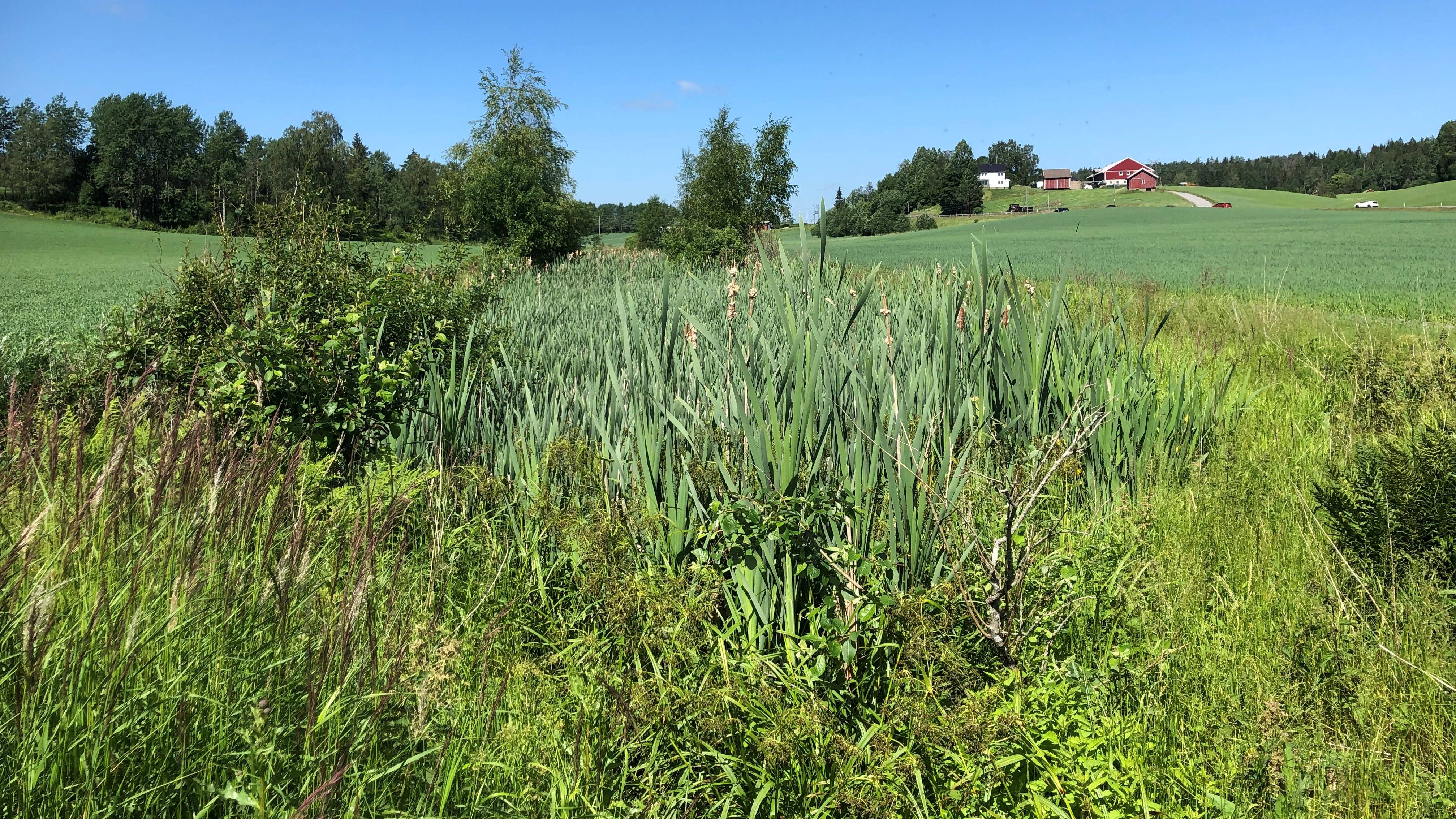
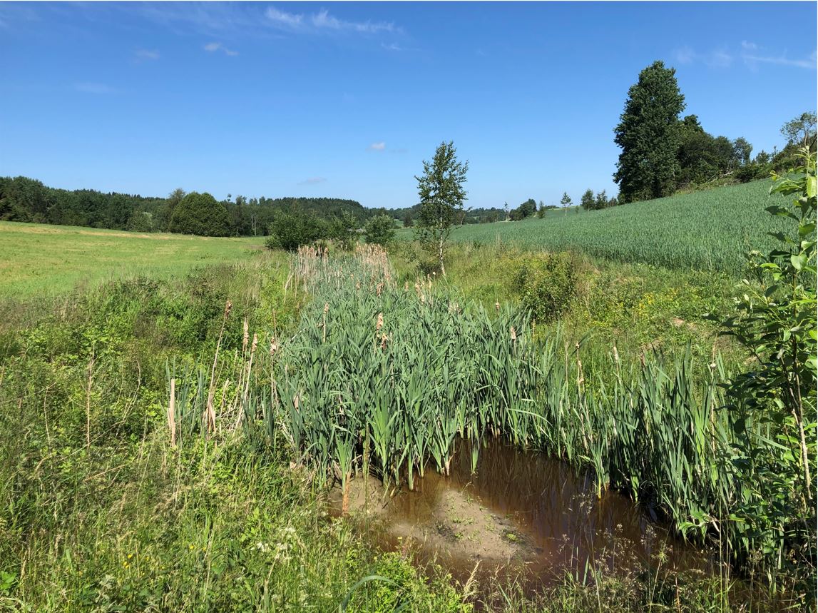
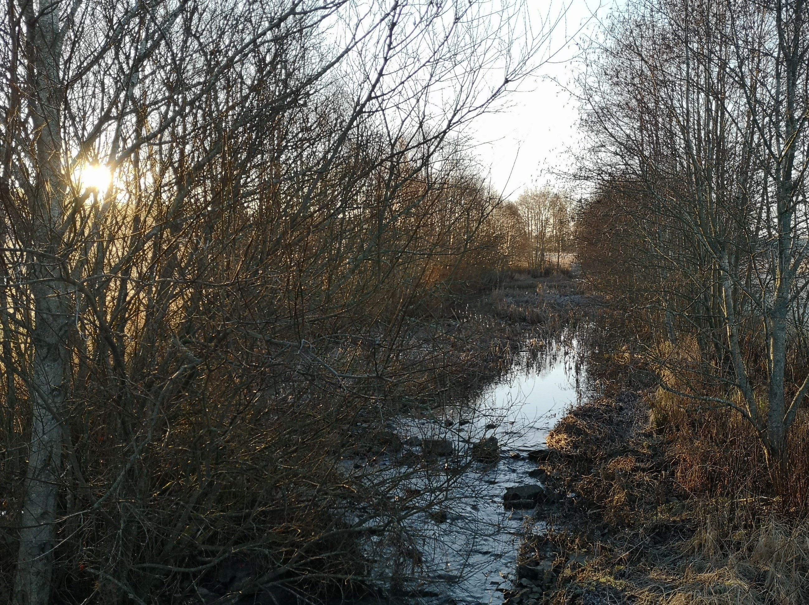
A small constructed wetland is a combination of ponds and vegetation filters, designed mainly to remove sediment and nutrients from streams. It is usually located in first and second order streams in agricultural landscapes.
2.2 การอธิบายแบบละเอียดของเทคโนโลยี
คำอธิบาย:
Purpose/aim: Small constructed wetlands (CWs) are designed to improve water quality in streams and thus downstream water quality as well. The shape of the constructed wetlands can differ and include different components. Generally, they include a deeper sedimentation pond at the inlet (depth 1.5-2 m), followed by one or more shallow vegetated zones (depth 0.5 m). The sedimentation pond decreases the water velocity to allow particles to settle, while the vegetated, shallower zones act as filters for particles passing the sedimentation pond and protect trapped sediments from re-suspension by stabilizing them with their roots.
Small constructed wetlands treating agricultural runoff have been in operation in Norway since the early 1990s. From 1994-2020, more than 1200 CWs have been established across the country, with the aim of reducing sediment, nutrients, pesticides and other pollutants in agricultural runoff.
Establishment/maintenance: Norwegian CW are designed mainly to remove phosphorus and particles (suspended sediment) with main removal mechanism being sedimentation and filtration, and (to a lesser extent) plant uptake. The CWs treating agricultural runoff are usually constructed by expanding the width of natural streams. At the inlet of the CW, the stream water flows into a sedimentation pond. From the sedimentation pond, water passes through a sprinkling zone, and then through one or more vegetated wetland filters. Due to the typical small-scale Norwegian agriculture and the landscape with rough topography, CWs are often quite small (<0.1 % of the catchment area). The size of CWs is one of the crucial factors limiting overall treatment efficiency.
Over the years, the CW will fill up with sediments, and to maintain good treatment efficiency, it is necessary to empty the CWs periodically (Blankenberg et al. 2013 ).
Benefits/impacts: Norwegian studies show that retention of total phosphorus (TP), both particulate P and dissolved P, increase with increasing area of the CW (Braskerud et al. 2005 ). The retention of sediments, nutrients and pesticides in different CWs also varies due to other factors like design principles, soil types in the catchment, hydraulic loads, and locations along the streams (Braskerud and Blankenberg 2005 ; Blankenberg et al. 2007 , 2008 ; Elsaesser et al. 2011 ). Braskerud ( 2001 ) showed that average retention in six CWs in Norway varied from 45% to 74% for soil particles and 21%–44% for TP. For CW in Skuterud catchment Krzeminska et al (2021) showed that average efficiency of removal was 36% of sediment, 19% of phosphorus and 3% of nitrogen .
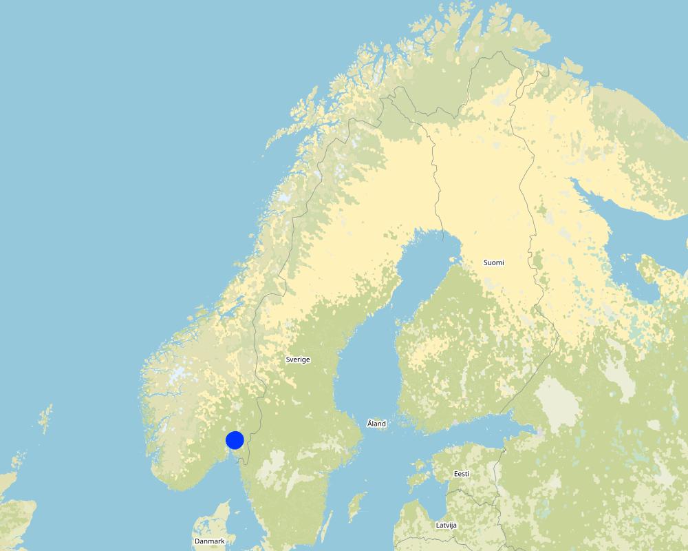
Natural / human environment: The information presented here is based on the investigations and/or reports from different part of Norway. For the purpose of OPTAIN project, the technology is further presented in the natural and human environment context of the Kråkstad River catchment - a Norwegian Case Study catchment within OPTAIN project.
The Kråkstad River is mainly situated in Ski commune in South-Eastern parts of Norway. The river catchment is a western tributary of the Vannsjø-Hobøl watercourse, also known as the Morsa watercourse. The Kråkstad River catchment area is c.a 51 km², 43% of which is agricultural land, where mostly cereals are produced on heavy clays soils. The main environmental challenge in the area is water quality (incl. high phosphorus pollution) and soil erosion (incl. riverbank erosion and quick-clay landslides).
2.3 รูปภาพของเทคโนโลยี
อัลบั้มสื่อบันทึก
2.5 ประเทศภูมิภาค หรือสถานที่ตั้งที่เทคโนโลยีได้นำไปใช้และได้รับการครอบคลุมโดยการประเมินนี้
ประเทศ:
นอร์เวย์
ภูมิภาค/รัฐ/จังหวัด:
Viken county
ข้อมูลจำเพาะเพิ่มเติมของสถานที่ตั้ง :
The Vansø - Hobøl catchment
ระบุการกระจายตัวของเทคโนโลยี:
- ใช้ ณ จุดที่เฉพาะเจาะจงหรือเน้นไปยังบริเวณพื้นที่ขนาดเล็ก
Is/are the technology site(s) located in a permanently protected area?
ไม่ใช่
แสดงความคิดเห็น:
Here we show only some example locations within the Kråkstad catchment
Map
×2.6 วันที่การดำเนินการ
ถ้าไม่รู้ปีที่แน่นอน ให้ระบุวันที่โดยประมาณ:
- 10-50 ปี
2.7 คำแนะนำของเทคโนโลยี
ให้ระบุว่าเทคโนโลยีถูกแนะนำเข้ามาอย่างไร:
- ในช่วงการทดลองหรือการทำวิจัย
- SMIL (Special Environmental measures in agriculture)
ความคิดเห็น (ประเภทของโครงการ เป็นต้น) :
Constructed wetlands are part of SMIL subsidy system (Special Environmental measures in Agriculture)
3. การจัดประเภทของเทคโนโลยี SLM
3.1 วัตถุประสงค์หลักของเทคโนโลยี
- ป้องกันพื้นที่ลุ่มน้ำ/บริเวณท้ายน้ำ โดยร่วมกับเทคโนโลยีอื่นๆ
- ปรับตัวเข้ากับการเปลี่ยนแปลงภูมิอากาศของโลก สภาพภูมิอากาศที่รุนแรงและผลกระทบ
- ชะลอการเปลี่ยนแปลงภูมิอากาศของโลกและผลกระทบ
3.2 ประเภทของการใช้ที่ดินในปัจจุบันที่ได้นำเทคโนโลยีไปใช้
Land use mixed within the same land unit:
ไม่ใช่

พื้นที่ปลูกพืช
- การปลูกพืชล้มลุกอายุปีเดียว
Annual cropping - Specify crops:
- cereals - other
- small grains
จำนวนของฤดูเพาะปลูกต่อปี:
- 1
ระบุ:
Longest growing period in days: 135. Longest growing period from month to month: May to mid September
Is intercropping practiced?
ไม่ใช่
Is crop rotation practiced?
ไม่ใช่

ป่า/พื้นที่ทำไม้
- Natrual forest

ทางน้ำ แหล่งน้ำ พื้นที่ชุ่มน้ำ
- ทางระบายน้ำ ทางน้ำ
3.3 Has land use changed due to the implementation of the Technology?
Has land use changed due to the implementation of the Technology?
- No (Continue with question 3.4)
ทางน้ำ แหล่งน้ำ พื้นที่ชุ่มน้ำ
- บ่อน้ำ เขื่อน
- หนองบึง พื้นที่ชุ่มน้ำ
3.4 การใช้น้ำ
การใช้น้ำของที่ดินที่มีการใช้เทคโนโลยีอยู่:
- จากน้ำฝน
3.5 กลุ่ม SLM ที่ตรงกับเทคโนโลยีนี้
- การจัดการน้ำผิวดิน (น้ำพุ แม่น้ำทะเลสาบ ทะเล)
- การป้องกัน / การจัดการพื้นที่ชุ่มน้ำ
3.6 มาตรการ SLM ที่ประกอบกันเป็นเทคโนโลยี

มาตรการอนุรักษ์ด้วยโครงสร้าง
- S5: เขื่อน ชั้นดินที่แน่นแข็งบ่อน้ำ
3.7 รูปแบบหลักของการเสื่อมโทรมของที่ดินที่ได้รับการแก้ไขโดยเทคโนโลยี

การเสื่อมโทรมของน้ำ
- Hp (Decline of surface water quality): การลดลงของคุณภาพน้ำที่ผิวดิน
3.8 การป้องกัน การลดลง หรือการฟื้นฟูความเสื่อมโทรมของที่ดิน
ระบุเป้าหมายของเทคโนโลยีกับความเสื่อมโทรมของที่ดิน:
- ป้องกันความเสื่อมโทรมของที่ดิน
- ลดความเสื่อมโทรมของดิน
4. ข้อมูลจำเพาะด้านเทคนิค กิจกรรมการนำไปปฏิบัติใช้ ปัจจัยนำเข้า และค่าใช้จ่าย
4.1 แบบแปลนทางเทคนิคของเทคโนโลยี
ข้อมูลจำเพาะด้านเทคนิค (แบบแปลนทางเทคนิคของเทคโนโลยี):
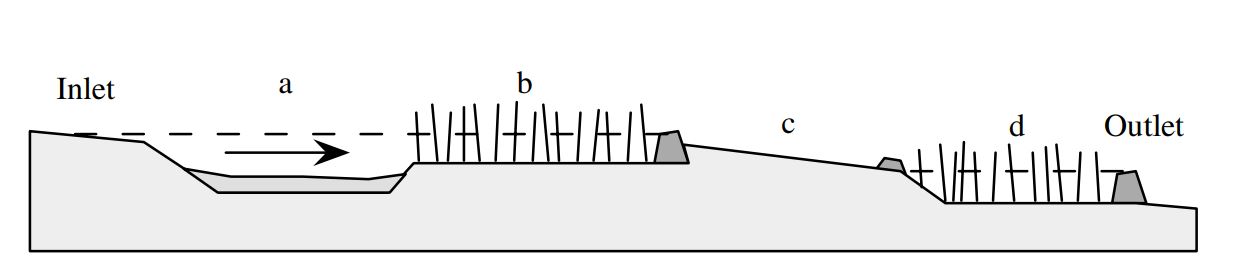
Components of typical constructed wetland in Norway: (a) sedimentation pond, (b) wetland filter, (c) overflow zone covered with vegetation or stones and (d) outlet basin.
ผู้เขียน:
B.C. Braskerud (2002)
วันที่:
26/01/2022
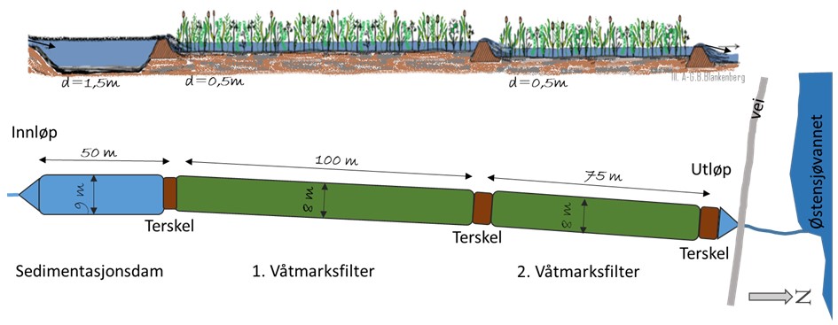
ข้อมูลจำเพาะด้านเทคนิค (แบบแปลนทางเทคนิคของเทคโนโลยี):
Schematic representation of constructed wetland in Skuterud catchment.
ผู้เขียน:
Anne-Grete Buseth Blankenberg (e.g. in the report from 2021)
วันที่:
26/01/2022
4.2 ข้อมูลทั่วไปเกี่ยวกับการคำนวณปัจจัยนำเข้าและค่าใช้จ่าย
ให้ระบุว่าค่าใช้จ่ายและปัจจัยนำเข้าได้รับการคำนวณอย่างไร:
- ต่อหน่วยเทคโนโลยี
โปรดระบุหน่วย:
constructed wetland - area of water surface
Specify dimensions of unit (if relevant):
<0.1 % of the catchment area. For Skuterud wetland it is 2300 m2
อื่นๆ หรือสกุลเงินประจำชาติ (ระบุ):
NOK
If relevant, indicate exchange rate from USD to local currency (e.g. 1 USD = 79.9 Brazilian Real): 1 USD =:
8.89
ระบุค่าเฉลี่ยของค่าจ้างในการจ้างแรงงานต่อวัน:
1440
4.3 กิจกรรมเพื่อการจัดตั้ง
| กิจกรรม | Timing (season) | |
|---|---|---|
| 1. | Construction of the wetland |
4.4 ค่าใช้จ่ายของปัจจัยนำเข้าที่จำเป็นสำหรับการจัดตั้ง
If you are unable to break down the costs in the table above, give an estimation of the total costs of establishing the Technology:
87500.0
ถ้าผู้ใช้ที่ดินรับภาระน้อยกว่า 100% ของค่าใช้จ่าย ให้ระบุว่าใครเป็นผู้รับผิดชอบส่วนที่เหลือ:
The landowners can apply for subsidies to establish and maintenance constructed wetland (70% support of the cost), within SMIL system (Special Environmental measures in Agriculture). Local county authorities are responsible for the administration of these schemes.
แสดงความคิดเห็น:
The information about cost are coming from Blankenber et al (2016):
During a period of 20 years (1994 - 2014) the government has spent in total about 88 million Norwegian crowns (NOK) to subsidize the CWs for agricultural runoff, and total
costs are assumed to be about 150 mill NOK. Costs per CW varies from about 26.000 NOK to 124.000 NOK, and average cost per CW is approximately 87.500 NOK.
4.5 การบำรุงรักษาสภาพหรือกิจกรรมที่เกิดขึ้นเป็นประจำ
| กิจกรรม | ช่วงระยะเวลา/ความถี่ | |
|---|---|---|
| 1. | Maintenance - emptying the ponds | every 5-20 years depending on dimensions of the ponds. |
| 2. | Maintenance of the damming/barriers | when needed |
| 3. | Maintenance of stream banks | when needed |
4.6 ค่าใช้จ่ายของปัจจัยนำเข้าและกิจกรรมที่เกิดขึ้นเป็นประจำที่ต้องการการบำรุงรักษา (ต่อปี)
If you are unable to break down the costs in the table above, give an estimation of the total costs of maintaining the Technology:
41000.0
ถ้าผู้ใช้ที่ดินรับภาระน้อยกว่า 100% ของค่าใช้จ่าย ให้ระบุว่าใครเป็นผู้รับผิดชอบส่วนที่เหลือ:
The landowners can apply for subsidies to establish and maintenance constructed wetland (70 % support of the cost), within SMIL system (Special Environmental measures in Agriculture). Local county authorities are responsible for the administration of these schemes.
แสดงความคิดเห็น:
The information is coming from (Hauge et al 2008):
The cost of maintenance of CWs estimated based n data from 2008 from 16 ponds established or planned in Morsa water region (that includes Kråkstad catchment). The (estimated) costs varied from 5,67 NOK/m2 of water surface area up to 49 NOK/m2 of water surface area
Given number of 41000 NOK is calculated for SKuterud CW (2300 m2 of water surface area).
4.7 ปัจจัยสำคัญที่สุดที่มีผลกระทบต่อค่าใช้จ่าย
ปัจจัยสำคัญที่สุดที่มีผลกระทบต่อค่าใช้จ่ายต่างๆ:
The most important factor affecting the costs of constructed wetland is the size. Larger constructed wetlands have lower establishment costs per m2 of water surface area. In terms of operating costs for capture ponds - mainly emptying the sedimentation pond - it is assumed that the cost per emptying is more or less independent of the size of the sedimentation pond. This is because a large component in the emptying cost is assumed to be the transport of the machinery and the removal of the excavated mass.
The landowners can apply for subsidies to establish and maintenance constructed wetland (70% support of the cost), within SMIL system (Special Environmental measures in Agriculture). Local county authorities are responsible for the administration of these schemes.
5. สิ่งแวดล้อมทางธรรมชาติและของมนุษย์
5.1 ภูมิอากาศ
ฝนประจำปี
- < 250 ม.ม.
- 251-500 ม.ม.
- 501-750 ม.ม.
- 751-1,000 ม.ม.
- 1,001-1,500 ม.ม.
- 1,501-2,000 ม.ม.
- 2,001-3,000 ม.ม.
- 3,001-4,000 ม.ม.
- > 4,000 ม.ม.
เขตภูมิอากาศเกษตร
- กึ่งชุ่มชื้น
- กึ่งแห้งแล้ง
5.2 สภาพภูมิประเทศ
ค่าเฉลี่ยความลาดชัน:
- ราบเรียบ (0-2%)
- ลาดที่ไม่ชัน (3-5%)
- ปานกลาง (6-10%)
- เป็นลูกคลื่น (11-15%)
- เป็นเนิน (16-30%)
- ชัน (31-60%)
- ชันมาก (>60%)
ธรณีสัณฐาน:
- ที่ราบสูง/ที่ราบ
- สันเขา
- ไหล่เขา
- ไหล่เนินเขา
- ตีนเนิน
- หุบเขา
ระดับความสูง:
- 0-100 เมตร
- 101-500 เมตร
- 501-1,000 เมตร
- 1,001-1,500 เมตร
- 1,501-2,000 เมตร
- 2,001-2,500 เมตร
- 2,501-3,000 เมตร
- 3,001-4,000 เมตร
- > 4,000 เมตร
ให้ระบุถ้าเทคโนโลยีได้ถูกนำไปใช้:
- ไม่เกี่ยวข้อง
5.3 ดิน
ค่าเฉลี่ยความลึกของดิน:
- ตื้นมาก (0-20 ซ.ม.)
- ตื้น (21-50 ซ.ม.)
- ลึกปานกลาง (51-80 ซ.ม.)
- ลึก (81-120 ซ.ม.)
- ลึกมาก (>120 ซ.ม.)
เนื้อดิน (ดินชั้นบน):
- ปานกลาง (ดินร่วน ทรายแป้ง)
- ละเอียด/หนัก (ดินเหนียว)
เนื้อดินล่าง (> 20 ซ.ม.ต่ำจากผิวดิน):
- ปานกลาง (ดินร่วน ทรายแป้ง)
- ละเอียด/หนัก (ดินเหนียว)
อินทรียวัตถุในดิน:
- ปานกลาง (1-3%)
5.4 ความเป็นประโยชน์และคุณภาพของน้ำ
ระดับน้ำใต้ดิน:
<5 เมตร
น้ำไหลบ่าที่ผิวดิน:
ดี
คุณภาพน้ำ (ที่ยังไม่ได้บำบัด):
เป็นน้ำใช้เพื่อการเกษตรเท่านั้น (การชลประทาน)
Water quality refers to:
both ground and surface water
ความเค็มของน้ำเป็นปัญหาหรือไม่:
ไม่ใช่
กำลังเกิดน้ำท่วมในพื้นที่หรือไม่:
ใช่
บ่อยครั้ง:
บ่อยครั้ง
5.5 ความหลากหลายทางชีวภาพ
ความหลากหลายทางชนิดพันธุ์:
- ต่ำ
ความหลากหลายของแหล่งที่อยู่:
- ต่ำ
5.6 ลักษณะของผู้ใช้ที่ดินที่นำเทคโนโลยีไปปฏิบัติใช้
อยู่กับที่หรือเร่ร่อน:
- อยู่กับที่
แนวทางการตลาดของระบบการผลิต:
- mixed (subsistence/ commercial)
- ทำการค้า/การตลาด
รายได้ที่มาจากนอกฟาร์ม:
- 10-50% ของรายได้ทั้งหมด
- > 50% ของรายได้ทั้งหมด
ระดับของความมั่งคั่งโดยเปรียบเทียบ:
- พอมีพอกิน
- รวย
เป็นรายบุคคล/ครัวเรือน:
- เป็นรายบุคคล/ครัวเรือน
ระดับของการใช้เครื่องจักรกล:
- การใช้เครื่องจักรหรือเครื่องยนต์
เพศ:
- หญิง
- ชาย
อายุของผู้ใช้ที่ดิน:
- ผู้เยาว์
- วัยกลางคน
ระบุลักษณะอื่นๆที่เกี่ยวข้องของผู้ใช้ที่ดิน:
Population density: < 10 persons/km2
Annual population growth: < 0.5%
10% of the land users are rich and own 10% of the land.
90% of the land users are average wealthy and own 90% of the land.
5.7 Average area of land used by land users applying the Technology
- < 0.5 เฮกตาร์
- 0.5-1 เฮกตาร์
- 1-2 เฮกตาร์
- 2-5 เฮกตาร์
- 5-15 เฮกตาร์
- 15-50 เฮกตาร์
- 50-100 เฮกตาร์
- 100-500 เฮกตาร์
- 500-1,000 เฮกตาร์
- 1,000-10,000 เฮกตาร์
- >10,000 เฮกตาร์
พิจารณาว่าเป็นขนาดเล็ก กลาง หรือขนาดใหญ่ (ซึ่งอ้างอิงถึงบริบทระดับท้องถิ่น):
- ขนาดกลาง
5.8 กรรมสิทธิ์ในที่ดิน สิทธิในการใช้ที่ดินและสิทธิในการใช้น้ำ
กรรมสิทธิ์ในที่ดิน:
- รายบุคคล ได้รับสิทธิครอบครอง
สิทธิในการใช้ที่ดิน:
- เกี่ยวกับชุมชน (ถูกจัดระเบียบ)
- รายบุคคล
สิทธิในการใช้น้ำ:
- เข้าถึงได้แบบเปิด (ไม่ได้จัดระเบียบ)
5.9 การเข้าถึงบริการและโครงสร้างพื้นฐาน
สุขภาพ:
- จน
- ปานกลาง
- ดี
การศึกษา:
- จน
- ปานกลาง
- ดี
ความช่วยเหลือทางด้านเทคนิค:
- จน
- ปานกลาง
- ดี
การจ้างงาน (เช่น ภายนอกฟาร์ม):
- จน
- ปานกลาง
- ดี
ตลาด:
- จน
- ปานกลาง
- ดี
พลังงาน:
- จน
- ปานกลาง
- ดี
ถนนและการขนส่ง:
- จน
- ปานกลาง
- ดี
น้ำดื่มและการสุขาภิบาล:
- จน
- ปานกลาง
- ดี
บริการด้านการเงิน:
- จน
- ปานกลาง
- ดี
6. ผลกระทบและสรุปคำบอกกล่าว
6.1 ผลกระทบในพื้นที่ดำเนินการ (On-site) จากการใช้เทคโนโลยี
ผลกระทบทางด้านเศรษฐกิจและสังคม
การผลิต
พื้นที่สำหรับการผลิต
ผลกระทบด้านนิเวศวิทยา
วัฐจักรน้ำหรือน้ำบ่า
คุณภาพน้ำ
ดิน
การสูญเสียดิน
แสดงความคิดเห็น/ระบุ:
The sediment taken out from the sedimentation pond can be distributed on the agricultural field - soil recovery.
การหมุนเวียนและการเติมของธาตุอาหาร
แสดงความคิดเห็น/ระบุ:
The sediment taken out from the sedimentation pond can be distributed on the agricultural field - nutrient recovery.
ความหลากหลายทางชีวภาพของพืชและสัตว์
ความหลากหลายทางชีวภาพของพืช
ความหลากหลายทางชีวภาพของสัตว์
ความหลากหลายของสัตว์
6.2 ผลกระทบนอกพื้นที่ดำเนินการ (Off-site) จากการใช้เทคโนโลยี
การทับถมของดินตะกอนพื้นที่ท้ายน้ำ
แสดงความคิดเห็น/ระบุ:
Better water quality downstream
ความสามารถต้านทานการเปลี่ยนแปลง / ความสามารถในการคัดกรอง
6.3 การเผชิญและความตอบสนองของเทคโนโลยีต่อการเปลี่ยนแปลงสภาพภูมิอากาศที่ค่อยเป็นค่อยไป และสภาพรุนแรงของภูมิอากาศ / ภัยพิบัติ (ที่รับรู้ได้โดยผู้ใช้ที่ดิน)
การเปลี่ยนแปลงสภาพภูมิอากาศที่ค่อยเป็นค่อยไป
การเปลี่ยนแปลงสภาพภูมิอากาศที่ค่อยเป็นค่อยไป
| ฤดู | increase or decrease | เทคโนโลยีมีวิธีการรับมืออย่างไร | |
|---|---|---|---|
| อุณหภูมิประจำปี | เพิ่มขึ้น | ดี | |
| ฝนประจำปี | เพิ่มขึ้น | ดี |
สภาพรุนแรงของภูมิอากาศ (ภัยพิบัติ)
ภัยพิบัติจากน้ำ
| เทคโนโลยีมีวิธีการรับมืออย่างไร | |
|---|---|
| น้ำท่วมตามปกติ (แม่น้ำ) | ดี |
6.4 การวิเคราะห์ค่าใช้จ่ายและผลประโยชน์ที่ได้รับ
ผลประโยชน์ที่ได้รับเปรียบเทียบกับค่าใช้จ่ายในการจัดตั้งเป็นอย่างไร (จากมุมมองของผู้ใช้ที่ดิน)
ผลตอบแทนระยะสั้น:
ด้านบวกเล็กน้อย
ผลตอบแทนระยะยาว:
ด้านบวกเล็กน้อย
ผลประโยชน์ที่ได้รับเปรียบเทียบกับค่าใช้จ่ายในการบำรุงรักษาหรือต้นทุนที่เกิดขึ้นซ้ำอีก เป็นอย่างไร (จากมุมมองของผู้ใช้ที่ดิน)
ผลตอบแทนระยะสั้น:
ด้านบวกเล็กน้อย
ผลตอบแทนระยะยาว:
ด้านบวกเล็กน้อย
6.5 การปรับตัวของเทคโนโลยี
- 1-10%
Of all those who have adopted the Technology, how many did so spontaneously, i.e. without receiving any material incentives/ payments?
- 0-10%
แสดงความคิดเห็น:
Adaptation of technology is stimulated by subsidies scheme.
Subsidies for the establishment of constructed wetlands are part of the SMIL system (Special Environmental Measures in Agriculture). Both the initial investment for construction and
subsequent maintenance may be paid by subsidies (70% support of the cost). During the period from 1994 to 2012 subsidies for in total 941 sedimentation ponds and constructed wetlands were given in Norway (Greipsland, 2016)
6.6 การปรับตัว
เทคโนโลยีได้รับการปรับเปลี่ยนเมื่อเร็วๆนี้ เพื่อให้ปรับตัวเข้ากับสภาพที่กำลังเปลี่ยนแปลงหรือไม่:
ไม่ใช่
6.7 จุดแข็ง / ข้อได้เปรียบ / โอกาสของเทคโนโลยี
| จุดแข็ง / ข้อได้เปรียบ / โอกาสในทัศนคติของผู้ใช้ที่ดิน |
|---|
| Improvement of water quality downstream |
| จุดแข็ง / ข้อได้เปรียบ / โอกาสในทัศนคติของผู้รวบรวมหรือวิทยากรหลัก |
|---|
| Improve of water quality downstream |
| Resource recovery |
6.8 จุดอ่อน / ข้อเสียเปรียบ / ความเสี่ยงของเทคโนโลยีและวิธีการแก้ไข
| จุดอ่อน / ข้อเสียเปรียบ / ความเสี่ยงในทัศนคติของผู้ใช้ที่ดิน | มีวิธีการแก้ไขได้อย่างไร |
|---|---|
| Loss of productive cropland | |
| Need for maintenance |
7. การอ้างอิงและการเชื่อมต่อ
7.1 วิธีการและแหล่งข้อมูล
- ไปเยี่ยมชมภาคสนาม การสำรวจพื้นที่ภาคสนาม
Several in different areas in Norway. See for example:
- Hauge et al (2008) Bioforsk Report vol 3 Nr 140 (in Norwegian)
- Krzeminska et al (2021) Nibio Report 7(101) (in Norwegian)
- การสัมภาษณ์ผู้เชี่ยวชาญด้าน SLM หรือผู้ชำนาญ
NIBIO, and its SLM specialists, has been conducting many national projects related to monitoring constructed wetlands in agricultural catchments.
- การเก็บรวบรวมมาจากรายงานและเอกสารที่มีอยู่
There are several reports and research publication available. Some examples below:
- Braskerud, B.C et al (2001) Dr. Scient. Theses 2001:10,
Agriculture University of Norway, Ås, Norway.
- Braskerud, B. C. (2002). Water Science and Technology Vol 45 No 9 pp 77–85.
- Braskerud, B.C et al (2005).Journal of Environmental Quality , 34(6), 2145–2155.
- Braskerud B.C. and Blankenberg A-G. B (2005) Jordforsk book nr. 48/05. 145: 126–128.
- Blankenberg, A.-G. B et al. (2007) Water Science and Technology, 55(3), 37–44.
- Blankenberg, A.-G. B et al. (2008) Desalination, 226, 114–120.
- Hauge et al (2008) Bioforsk Report vol 3 Nr 140 (in Norwegian)
- Blankenberg et al (2016) in Natural and Constructed Wetlands. DOI 10.1007/978-3-319-38927-1_2
- Krzeminska et al (2021) Nibio Report 7(101) (in Norwegian)
วันที่เก็บรวบรวมข้อมูล(ภาคสนาม) :
26/01/2022
7.2 การอ้างอิงถึงสิ่งตีพิมพ์
หัวข้อ, ผู้เขียน, ปี, หมายเลข ISBN:
Hauge A., Blankenberg A-G. B., Hanserud O.H. 2008. Evaluering av fangdammer som miljøtiltak i SMIL. Bioforsk Rapport Vol. 3 Nr. 140 2008.
ชื่อเรื่อง ผู้เขียน ปี ISBN:
https://evalueringsportalen.no/
หัวข้อ, ผู้เขียน, ปี, หมายเลข ISBN:
Blankenberg A-G.B., Paruch A.M., Paruch L., Deelstra J., Haarstad K. 2016. Nutrients tracking and removal in constructed wetlands treating catchment runoff in Norway. In: Vymazal J. (ed) Natural and Constructed Wetlands. Springer International Publishing Switzerland, pp. 23-40. DOI 10.1007/978-3-319-38927-1_2
ชื่อเรื่อง ผู้เขียน ปี ISBN:
Springer Book
หัวข้อ, ผู้เขียน, ปี, หมายเลข ISBN:
Krzeminska D., Blankenberg A-G., Bechmann M. Deelstra J. 2021. Effekt av fangdam i et endret klima. NIBIO-rapport;7(101)2021
ชื่อเรื่อง ผู้เขียน ปี ISBN:
NIBIO website
หัวข้อ, ผู้เขียน, ปี, หมายเลข ISBN:
Greipsland I.2016. Norwegian policy and practices regarding mitigation measures in agriculture.
ชื่อเรื่อง ผู้เขียน ปี ISBN:
NIBIO website
7.3 Links to relevant online information
ชื่อเรื่องหรือคำอธิบาย:
Hauge A., Blankenberg A-G. B., Hanserud O.H. 2008. Evaluering av fangdammer som miljøtiltak i SMIL. Bioforsk Rapport Vol. 3 Nr. 140 2008.
URL:
https://evalueringsportalen.no/evaluering/evalueringen-av-fangdammer-som-miljotiltak-i-smil/Rapport%20Evaluering%20av%20fangdammer%20-%20Bioforsk%20Jord%20og%20Milj%C3%B8.pdf/@@inline
ชื่อเรื่องหรือคำอธิบาย:
Krzeminska D., Blankenberg A-G., Bechmann M. Deelstra J. 2021. Effekt av fangdam i et endret klima. NIBIO-rapport;7(101)2021
URL:
https://nibio.brage.unit.no/nibio-xmlui/bitstream/handle/11250/2757116/NIBIO_RAPPORT_2021_7_101.pdf?sequence=4&isAllowed=y
ชื่อเรื่องหรือคำอธิบาย:
Greipsland I.2016. Norwegian policy and practices regarding mitigation measures in agriculture.
URL:
https://nibio.brage.unit.no/nibio-xmlui/bitstream/handle/11250/2387569/NIBIO_POP_2016_2_21.pdf?sequence=3&isAllowed=y
ลิงก์และโมดูล
ขยายทั้งหมด ย่อทั้งหมดลิงก์
Regional Environmental program [นอร์เวย์]
Regulations and financial grants for reduction of pollution and promotion of the cultural landscape.
- ผู้รวบรวม: Kamilla Skaalsveen
โมดูล
ไม่มีโมดูล