Longan, Plum interplanting [จีน]
- ผู้สร้างสรรค์:
- การอัพเดท:
- ผู้รวบรวม: zhangsheng LIU
- ผู้เรียบเรียง: –
- ผู้ตรวจสอบ: David Streiff, Alexandra Gavilano
Development of Southward Fruit Trees
technologies_942 - จีน
ดูส่วนย่อย
ขยายทั้งหมด ย่อทั้งหมด1. ข้อมูลทั่วไป
1.2 รายละเอียดที่ติดต่อได้ของผู้รวบรวมและองค์กรที่เกี่ยวข้องในการประเมินและการจัดเตรียมทำเอกสารของเทคโนโลยี
ชื่อขององค์กรซึ่งอำนวยความสะดวกในการทำเอกสารหรือการประเมินเทคโนโลยี (ถ้าเกี่ยวข้อง)
Water & Soil Conservation Office of Zhaoan County (Water & Soil Conservation Office of Zhaoan County) - จีน1.3 เงื่อนไขการใช้ข้อมูลที่ได้บันทึกผ่านทาง WOCAT
ผู้รวบรวมและวิทยากรหลักยอมรับเงื่อนไขเกี่ยวกับการใช้ข้อมูลที่ถูกบันทึกผ่านทาง WOCAT:
ใช่
1.5 Reference to Questionnaire(s) on SLM Approaches (documented using WOCAT)
Interplanting fruit trees of Longan, Peach, Plum etc. [จีน]
Interplanting plum, peach and other fruit trees in longan orchard on level terraces in order to prevent soil and water loss and improve production of the fruit trees.
- ผู้รวบรวม: zhangsheng LIU
2. การอธิบายลักษณะของเทคโนโลยี SLM
2.1 การอธิบายแบบสั้น ๆ ของเทคโนโลยี
คำจำกัดความของเทคโนโลยี:
Interplanting plum, peach in the Longan orchard to conserve soil and water and improve soil fertility.
2.2 การอธิบายแบบละเอียดของเทคโนโลยี
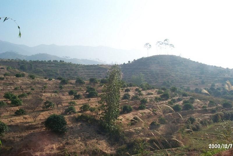
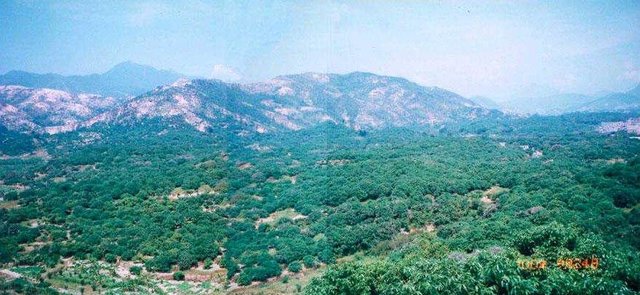
คำอธิบาย:
The technology is to interplant fruit trees in orchard so as to prevent water loss and soil erosion. To implement the project, local government gave financial support and SWC specialists gave technologically guide to local land users. The slope land in the hilly and mountain areas were constructed into terraces and plant trees in order to improve surface vegetation cover rate and reduce water and soil loss; the harvesting surplus rainfall in the raining season and irrigate the fruit trees in dry seasons.
2.3 รูปภาพของเทคโนโลยี
อัลบั้มสื่อบันทึก
2.5 ประเทศภูมิภาค หรือสถานที่ตั้งที่เทคโนโลยีได้นำไปใช้และได้รับการครอบคลุมโดยการประเมินนี้
ประเทศ:
จีน
ภูมิภาค/รัฐ/จังหวัด:
Fujian
ระบุการกระจายตัวของเทคโนโลยี:
- กระจายไปอย่างสม่ำเสมอในพื้นที่
If precise area is not known, indicate approximate area covered:
- 10-100 ตร.กม.
แสดงความคิดเห็น:
After the land users' arduously cultivating over many years, the former waste mountains have become a picture of vital force, the various growing fruit trees are very vital, water loss & soil erosion is controlled, and cultivated land can be used in a sustainable way.
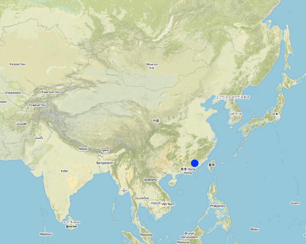
Map
×2.6 วันที่การดำเนินการ
ถ้าไม่รู้ปีที่แน่นอน ให้ระบุวันที่โดยประมาณ:
- มากกว่า 50 ปี (แบบดั้งเดิม)
2.7 คำแนะนำของเทคโนโลยี
ให้ระบุว่าเทคโนโลยีถูกแนะนำเข้ามาอย่างไร:
- ทางโครงการหรือจากภายนอก
ความคิดเห็น (ประเภทของโครงการ เป็นต้น) :
The technology originated from Institute of Water & Soil Conservation in Taiwan and improved by the national SWC specialists.
3. การจัดประเภทของเทคโนโลยี SLM
3.1 วัตถุประสงค์หลักของเทคโนโลยี
- ลด ป้องกัน ฟื้นฟู การเสื่อมโทรมของที่ดิน
3.2 ประเภทของการใช้ที่ดินในปัจจุบันที่ได้นำเทคโนโลยีไปใช้
Land use mixed within the same land unit:
ใช่
Specify mixed land use (crops/ grazing/ trees):
- วนเกษตร (Agroforestry)

พื้นที่ปลูกพืช
- การปลูกพืชล้มลุกอายุปีเดียว
- การปลูกพืชยืนต้นที่ไม่มีเนื้อไม้
- การปลูกไม้ยืนต้น ไม้พุ่ม
Tree and shrub cropping - Specify crops:
- stone fruits (peach, apricot, cherry, plum, etc)
จำนวนของฤดูเพาะปลูกต่อปี:
- 2
ระบุ:
Longest growing period in days: 240Longest growing period from month to month: Mar - OctSecond longest growing period in days: 120Second longest growing period from month to month: Nov - Feb
Is intercropping practiced?
ใช่
If yes, specify which crops are intercropped:
Interplanting plum, peach

ป่า/พื้นที่ทำไม้
ผลิตภัณฑ์และบริการ:
- ไม้ซุง
- ไม้ที่นำมาทำเป็นเชื้อเพลิง
- ผลไม้และถั่ว
แสดงความคิดเห็น:
Major land use problems (compiler’s opinion): The ground surface of the SWC application area did not plant grass and green manure. The soil in the mountaintop area is lean, where broadleaf forest could be planted.
Major land use problems (land users’ perception): Because the soil layer is thin and poor, the local farmers wouldn't like to invest in the area where water loss and soil erosion is serious.
Problems / comments regarding forest use: Commonly, supplementary planting of trees in the following Spring.
3.4 การใช้น้ำ
การใช้น้ำของที่ดินที่มีการใช้เทคโนโลยีอยู่:
- จากน้ำฝน
3.5 กลุ่ม SLM ที่ตรงกับเทคโนโลยีนี้
- มาตรการปลูกพืชขวางความลาดชัน (cross-slope measure)
3.6 มาตรการ SLM ที่ประกอบกันเป็นเทคโนโลยี

มาตรการอนุรักษ์ด้วยวิธีพืช
- V1: ต้นไม้และพุ่มไม้คลุมดิน
แสดงความคิดเห็น:
Type of agronomic measures: mixed cropping / intercropping, contour ridging
3.7 รูปแบบหลักของการเสื่อมโทรมของที่ดินที่ได้รับการแก้ไขโดยเทคโนโลยี

การกัดกร่อนของดินโดยน้ำ
- Wt (Loss of topsoil): การสูญเสียดินชั้นบนหรือการกัดกร่อนที่ผิวดิน
- Wg (Gully erosion): การกัดกร่อนแบบร่องธารหรือการทำให้เกิดร่องน้ำเซาะ
แสดงความคิดเห็น:
Main type of degradation addressed: Wt: loss of topsoil / surface erosion
Secondary types of degradation addressed: Wg: gully erosion / gullying
Main causes of degradation: over-exploitation of vegetation for domestic use (Causing land surface bare, ruderal cluster.), poverty / wealth (Lack of captial: hindering ulterior expanding of the water and soil conservation)
Secondary causes of degradation: Land subdivision (seperated land area can not be entirely developed)
3.8 การป้องกัน การลดลง หรือการฟื้นฟูความเสื่อมโทรมของที่ดิน
ระบุเป้าหมายของเทคโนโลยีกับความเสื่อมโทรมของที่ดิน:
- ลดความเสื่อมโทรมของดิน
4. ข้อมูลจำเพาะด้านเทคนิค กิจกรรมการนำไปปฏิบัติใช้ ปัจจัยนำเข้า และค่าใช้จ่าย
4.1 แบบแปลนทางเทคนิคของเทคโนโลยี
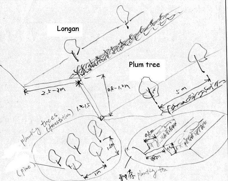
ข้อมูลจำเพาะด้านเทคนิค (แบบแปลนทางเทคนิคของเทคโนโลยี):
Technical drawing of interplanting in orchard.
Location: Zhaoan county. Fujian
Date: 1997
Technical knowledge required for field staff / advisors: moderate
Technical knowledge required for land users: low
Main technical functions: control of dispersed runoff: impede / retard
Secondary technical functions: reduction of slope angle, improvement of ground cover, wind-break
Mixed cropping / intercropping
Material/ species: Plum trees
Quantity/ density: 238
Remarks: increasing ground cover
Contour ridging
Remarks: reasonable layout
Trees/ shrubs species: jequirity tree
Perennial crops species: Plum, peach lichi trees
Slope (which determines the spacing indicated above): 30.00%
If the original slope has changed as a result of the Technology, the slope today is (see figure below): 15.00%
Gradient along the rows / strips: 60.00%
Construction material (earth): cheaper, local materials, good effect
Slope (which determines the spacing indicated above): 28.00%
If the original slope has changed as a result of the Technology, the slope today is: 13.00%
Lateral gradient along the structure: 26.00%
For water harvesting: the ratio between the area where the harvested water is applied and the total area from which water is collected is: 1:2.00
Vegetation is used for stabilisation of structures.
Change of land use practices / intensity level: Forbidding disafforest in mountain areas for 3 years.
ผู้เขียน:
LIU Zhangsheng, Zhaoan, China
4.2 ข้อมูลทั่วไปเกี่ยวกับการคำนวณปัจจัยนำเข้าและค่าใช้จ่าย
ระบุสกุลเงินที่ใช้คำนวณค่าใช้จ่าย:
- USD
If relevant, indicate exchange rate from USD to local currency (e.g. 1 USD = 79.9 Brazilian Real): 1 USD =:
8.3
ระบุค่าเฉลี่ยของค่าจ้างในการจ้างแรงงานต่อวัน:
2.40
4.3 กิจกรรมเพื่อการจัดตั้ง
| กิจกรรม | Timing (season) | |
|---|---|---|
| 1. | plant trees | spring |
| 2. | Level off land | winter |
| 3. | weed | winter |
| 4. | digging ditch | spring |
| 5. | Level off land | Autumn |
| 6. | costruct bank of field | winter |
| 7. | Closure and forbidding disafforest | 3 years |
4.4 ค่าใช้จ่ายของปัจจัยนำเข้าที่จำเป็นสำหรับการจัดตั้ง
แสดงความคิดเห็น:
Duration of establishment phase: 24 month(s)
4.5 การบำรุงรักษาสภาพหรือกิจกรรมที่เกิดขึ้นเป็นประจำ
| กิจกรรม | ช่วงระยะเวลา/ความถี่ | |
|---|---|---|
| 1. | digging ditch(interplant) | winter / Annually |
| 2. | irrigate | spring / Each cropping season |
| 3. | fertilization | Mar.Jun.Sep. /Annual |
| 4. | spew pesticide | Apl.Jul. /Annual |
| 5. | reinforce banks of level terrace | autumn/Annual |
| 6. | complementing seedling | spring / 1 |
| 7. | Fertilizing | Mar. Jun. / 2 |
4.6 ค่าใช้จ่ายของปัจจัยนำเข้าและกิจกรรมที่เกิดขึ้นเป็นประจำที่ต้องการการบำรุงรักษา (ต่อปี)
แสดงความคิดเห็น:
Slope angle degree, and earth volume being moved.
4.7 ปัจจัยสำคัญที่สุดที่มีผลกระทบต่อค่าใช้จ่าย
ปัจจัยสำคัญที่สุดที่มีผลกระทบต่อค่าใช้จ่ายต่างๆ:
Main factor influencing the SWC cost is steeper slope. Since the slope steeper is, much more cost needed to level off terrace. In some places, the earth needs to be moved from one place to another which will spend a lot of labor forces.
5. สิ่งแวดล้อมทางธรรมชาติและของมนุษย์
5.1 ภูมิอากาศ
ฝนประจำปี
- < 250 ม.ม.
- 251-500 ม.ม.
- 501-750 ม.ม.
- 751-1,000 ม.ม.
- 1,001-1,500 ม.ม.
- 1,501-2,000 ม.ม.
- 2,001-3,000 ม.ม.
- 3,001-4,000 ม.ม.
- > 4,000 ม.ม.
เขตภูมิอากาศเกษตร
- ชื้น
- กึ่งชุ่มชื้น
5.2 สภาพภูมิประเทศ
ค่าเฉลี่ยความลาดชัน:
- ราบเรียบ (0-2%)
- ลาดที่ไม่ชัน (3-5%)
- ปานกลาง (6-10%)
- เป็นลูกคลื่น (11-15%)
- เป็นเนิน (16-30%)
- ชัน (31-60%)
- ชันมาก (>60%)
ธรณีสัณฐาน:
- ที่ราบสูง/ที่ราบ
- สันเขา
- ไหล่เขา
- ไหล่เนินเขา
- ตีนเนิน
- หุบเขา
ระดับความสูง:
- 0-100 เมตร
- 101-500 เมตร
- 501-1,000 เมตร
- 1,001-1,500 เมตร
- 1,501-2,000 เมตร
- 2,001-2,500 เมตร
- 2,501-3,000 เมตร
- 3,001-4,000 เมตร
- > 4,000 เมตร
ให้ระบุถ้าเทคโนโลยีได้ถูกนำไปใช้:
- ไม่เกี่ยวข้อง
ความคิดเห็นและข้อมูลจำเพาะเพิ่มเติมเรื่องสภาพภูมิประเทศ:
slopes on average also moderate
5.3 ดิน
ค่าเฉลี่ยความลึกของดิน:
- ตื้นมาก (0-20 ซ.ม.)
- ตื้น (21-50 ซ.ม.)
- ลึกปานกลาง (51-80 ซ.ม.)
- ลึก (81-120 ซ.ม.)
- ลึกมาก (>120 ซ.ม.)
เนื้อดิน (ดินชั้นบน):
- หยาบ/เบา (ดินทราย)
- ปานกลาง (ดินร่วน ทรายแป้ง)
เนื้อดินล่าง (> 20 ซ.ม.ต่ำจากผิวดิน):
- หยาบ/เบา (ดินทราย)
- ปานกลาง (ดินร่วน ทรายแป้ง)
อินทรียวัตถุในดิน:
- ปานกลาง (1-3%)
- ต่ำ (<1%)
(ถ้ามี) ให้แนบคำอธิบายเรื่องดินแบบเต็มหรือระบุข้อมูลที่มีอยู่ เช่น ชนิดของดิน ค่า pH ของดินหรือความเป็นกรดของดิน ความสามารถในการแลกเปลี่ยนประจุบวก ไนโตรเจน ความเค็ม เป็นต้น:
Soil depth als moderatly deep
Soil fertility very low - medium
Soil drainage / infiltration medium - good
Soil water storage capacity medium - high
5.6 ลักษณะของผู้ใช้ที่ดินที่นำเทคโนโลยีไปปฏิบัติใช้
รายได้ที่มาจากนอกฟาร์ม:
- 10-50% ของรายได้ทั้งหมด
ระดับของความมั่งคั่งโดยเปรียบเทียบ:
- รวย
ระดับของการใช้เครื่องจักรกล:
- งานที่ใช้แรงกาย
- การใช้กำลังจากสัตว์
ระบุลักษณะอื่นๆที่เกี่ยวข้องของผู้ใช้ที่ดิน:
Population density: 100-200 persons/km2
Annual population growth: 0.5% - 1%
12% of the land users are very rich and own 12% of the land.
44% of the land users are rich and own 44% of the land.
35% of the land users are average wealthy and own 35% of the land.
9% of the land users are poor and own 9% of the land.
Off-farm income specification: Mainly in transport of goods and travelers, such as transport service. It needs much more idle labor forces.
5.8 กรรมสิทธิ์ในที่ดิน สิทธิในการใช้ที่ดินและสิทธิในการใช้น้ำ
กรรมสิทธิ์ในที่ดิน:
- รัฐ
- รายบุคคล ไม่ได้รับสิทธิครอบครอง
สิทธิในการใช้ที่ดิน:
- เช่า
6. ผลกระทบและสรุปคำบอกกล่าว
6.4 การวิเคราะห์ค่าใช้จ่ายและผลประโยชน์ที่ได้รับ
ผลประโยชน์ที่ได้รับเปรียบเทียบกับค่าใช้จ่ายในการจัดตั้งเป็นอย่างไร (จากมุมมองของผู้ใช้ที่ดิน)
ผลตอบแทนระยะสั้น:
ด้านลบเล็กน้อย
ผลตอบแทนระยะยาว:
ด้านบวกอย่างมาก
ผลประโยชน์ที่ได้รับเปรียบเทียบกับค่าใช้จ่ายในการบำรุงรักษาหรือต้นทุนที่เกิดขึ้นซ้ำอีก เป็นอย่างไร (จากมุมมองของผู้ใช้ที่ดิน)
ผลตอบแทนระยะสั้น:
เป็นกลางหรือสมดุล
ผลตอบแทนระยะยาว:
ด้านบวกอย่างมาก
6.5 การปรับตัวของเทคโนโลยี
- > 50%
ถ้ามีข้อมูลให้บอกปริมาณด้วย (จำนวนของครัวเรือนหรือครอบคลุมพื้นที่):
1253 households
Of all those who have adopted the Technology, how many did so spontaneously, i.e. without receiving any material incentives/ payments?
- 51-90%
แสดงความคิดเห็น:
80% of land user families have adopted the Technology with external material support
690 land user families have adopted the Technology with external material support
Comments on acceptance with external material support: survey results
20% of land user families have adopted the Technology without any external material support
563 land user families have adopted the Technology without any external material support
Comments on spontaneous adoption: survey results
There is a moderate trend towards spontaneous adoption of the Technology
Comments on adoption trend: The farmers have known that the SWC technology could produce benefits of improving agricultural production.
7. การอ้างอิงและการเชื่อมต่อ
7.1 วิธีการและแหล่งข้อมูล
ลิงก์และโมดูล
ขยายทั้งหมด ย่อทั้งหมดลิงก์
Interplanting fruit trees of Longan, Peach, Plum etc. [จีน]
Interplanting plum, peach and other fruit trees in longan orchard on level terraces in order to prevent soil and water loss and improve production of the fruit trees.
- ผู้รวบรวม: zhangsheng LIU
โมดูล
ไม่มีโมดูล