Indigenous water collecting pond and livestock watering trough [Tanzania, United Republic of]
- Creation:
- Update:
- Compiler: ALLAN BUBELWA
- Editor: –
- Reviewers: Donia Mühlematter, Fabian Ottiger, Alexandra Gavilano
elyeshero ne elyato (Haya tribe)
technologies_1157 - Tanzania, United Republic of
- Full summary as PDF
- Full summary as PDF for print
- Full summary in the browser
- Full summary (unformatted)
- Indigenous water collecting pond and livestock watering trough: Dec. 29, 2016 (inactive)
- Indigenous water collecting pond and livestock watering trough: June 5, 2017 (inactive)
- Indigenous water collecting pond and livestock watering trough: June 28, 2018 (inactive)
- Indigenous water collecting pond and livestock watering trough: Aug. 6, 2019 (public)
View sections
Expand all Collapse all1. General information
1.2 Contact details of resource persons and institutions involved in the assessment and documentation of the Technology
Key resource person(s)
government:
Kagaruki Annagrace
Misseny District Council
SLM specialist:
government:
Name of the institution(s) which facilitated the documentation/ evaluation of the Technology (if relevant)
Missenyi District Council (Missenyi District Council) - Tanzania, United Republic ofName of the institution(s) which facilitated the documentation/ evaluation of the Technology (if relevant)
FAO Food and Agriculture Organization (FAO Food and Agriculture Organization) - Italy1.3 Conditions regarding the use of data documented through WOCAT
The compiler and key resource person(s) accept the conditions regarding the use of data documented through WOCAT:
Yes
2. Description of the SLM Technology
2.1 Short description of the Technology
Definition of the Technology:
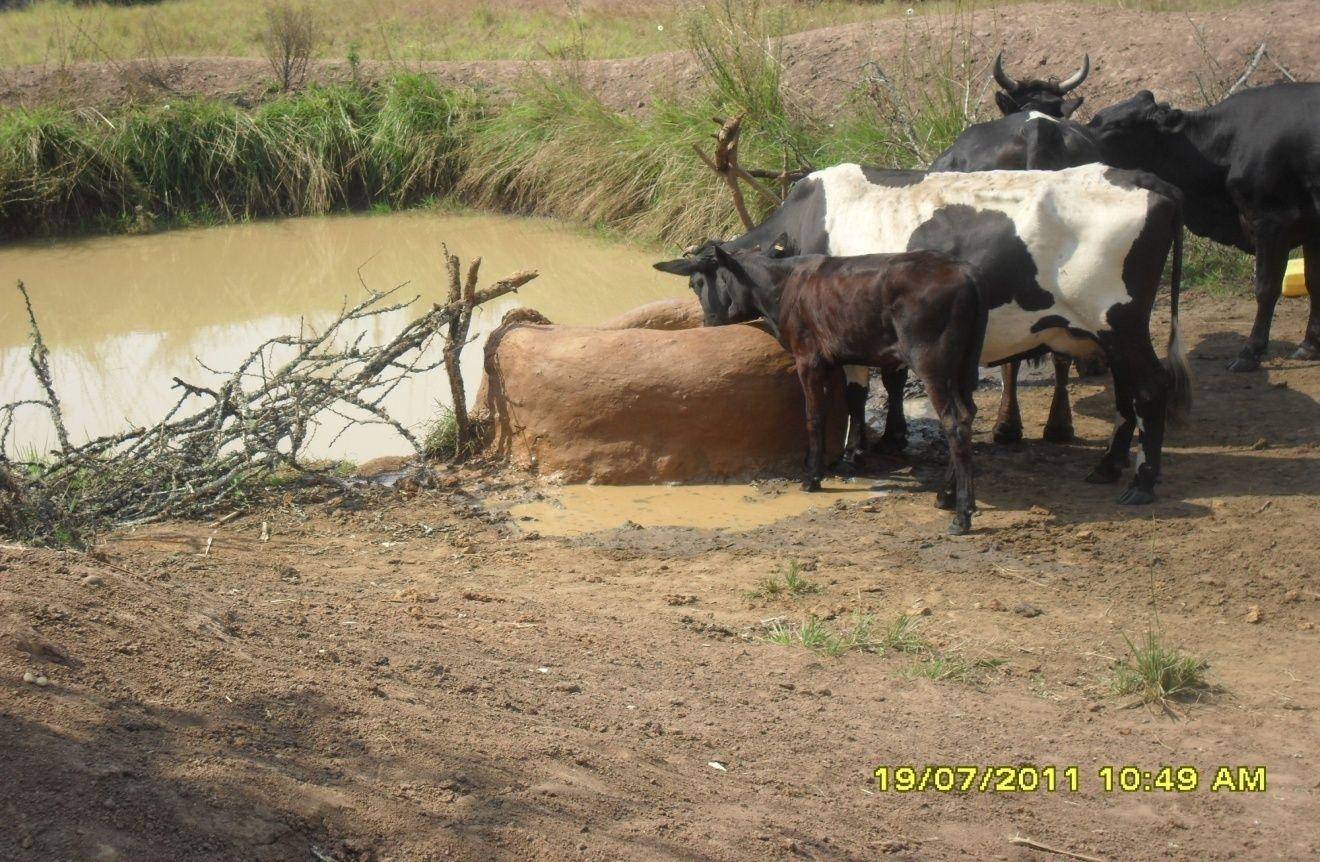
Construction of indigenous water pond and a livestock watering trough along an underground water source.
2.2 Detailed description of the Technology
Description:
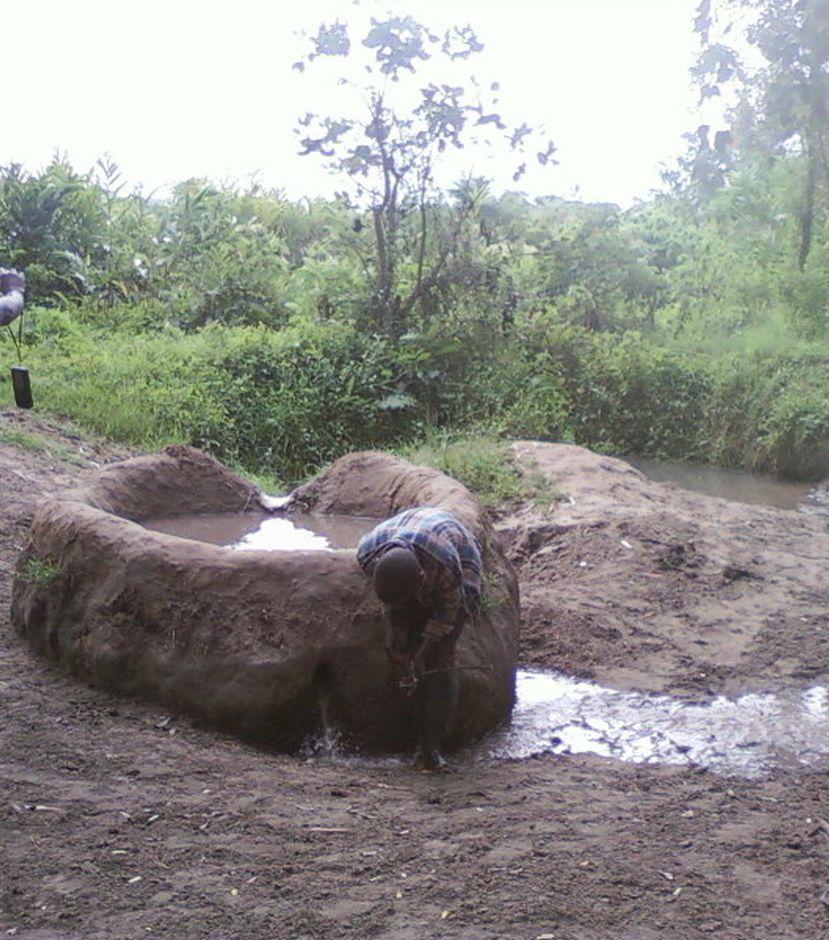
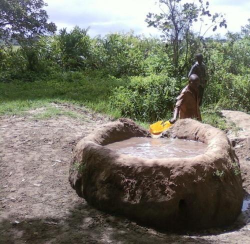
This technology is used during the dry seasons and where ground water level is high and there is natural water stream flowing from underground water source. Water pond is excavated along the naturally flowing water stream and is recharged by natural ground water. The size of the pond will vary depending on the area available, groundwater table, slope and soil characteristic. Groundwater collection ponds described in this technology on average are 4m long, 3m wide and 1m deep of 12m3 (12 000 liter) capacity and the slope is moderate 5% to 8% and soil characteristics is clay loam with deep soil. Water troughs (Elyato by local name) are constructed adjacent to the water pond to allow livestock to access clean drinking water. The number of troughs per pond is usually 1 to 2. Materials used in construction of water trough include clay, red termite mound soil, grass and wooden poles. The number of ponds needed usually depends on the expected number of animals and are arranged at irregular intervals ranging from 10 to 20 meters apart. The average size of a water trough is 0.14 m3 and can cater for 5 cattle at a time. The Pond is stabilized by naturally growing grass on its banks. Common pond stabilizer species are Leodicatiar digitalia and Hyperrhenia rufa. Management of the natural water source is through preventive village/customary by-laws which prohibit tree and grass cutting around the water source. The dominant indicator tree species normally found are Erythrina abysinica, Ficus thorgii and Phoenix recrinata. The animal watering troughs are usually used in the dry period. Before watering the troughs are coated (smeared) with red termite mound soil (normally hand carried by herders) to provide a good taste which is attractive to animals. Water is transferred from the pond to the water trough manually using cans or buckets. Animals drink directly from the troughs. This water from the trough is rich in iron (Fe) from red termite mound soil. The troughs are constructed with outlets used to spill out water immediately after drinking in order to prevent their damage through excessive water saturation.
Purpose of the Technology: This technology is preferred by livestock keepers as it provides for animals to drink clean and mineralized water and for health improvement. User fee payed to land owners also enable them to expand and diversify there income sources.
Establishment / maintenance activities and inputs: Establishment: Land clearing, excavation and shaping of water pond and construction of animal watering trough.
Maintenance: repair of water pond and water trough (de-siltation, grass slashing and gap refilling).
Inputs: labour, implements (machete, spade, hand hoe, sickle), clay, red termite mound soil, wooden poles, buckets, grass and tying rope. Average establishment cost for one pond and its water trough is 41.27 American dollars. Average annual maintenance and recurrent costs (filling and emptying of water trough) for one pond and its water trough stands at 458.76 dollars and labour is a core cost determinant factor.
Natural / human environment: Natural environment: Extensive grazing land. The technology is largely structural (excavation and shaping of water ponds and construction of water troughs) supported by the use of by-laws which prohibit destruction of the protective natural and indicative trees and grasses around. The technology is common in sub-humid climatic zone.
Social economic environment: Level of mechanization is handy tools with subsistence production systems on individual fields.
2.3 Photos of the Technology
Media Gallery
2.5 Country/ region/ locations where the Technology has been applied and which are covered by this assessment
Country:
Tanzania, United Republic of
Region/ State/ Province:
Tanzania
Further specification of location:
Missenyi District (Minziro)
Specify the spread of the Technology:
- evenly spread over an area
If precise area is not known, indicate approximate area covered:
- < 0.1 km2 (10 ha)
Comments:
Boundary points of the Technology area: -1.11472, 31.655 ; -1,09972, 31.70194
The area is owned by individual farmer. The area is found adjacent to extensive grazing land. Water table is high and there is a permanent underground natural water flows.
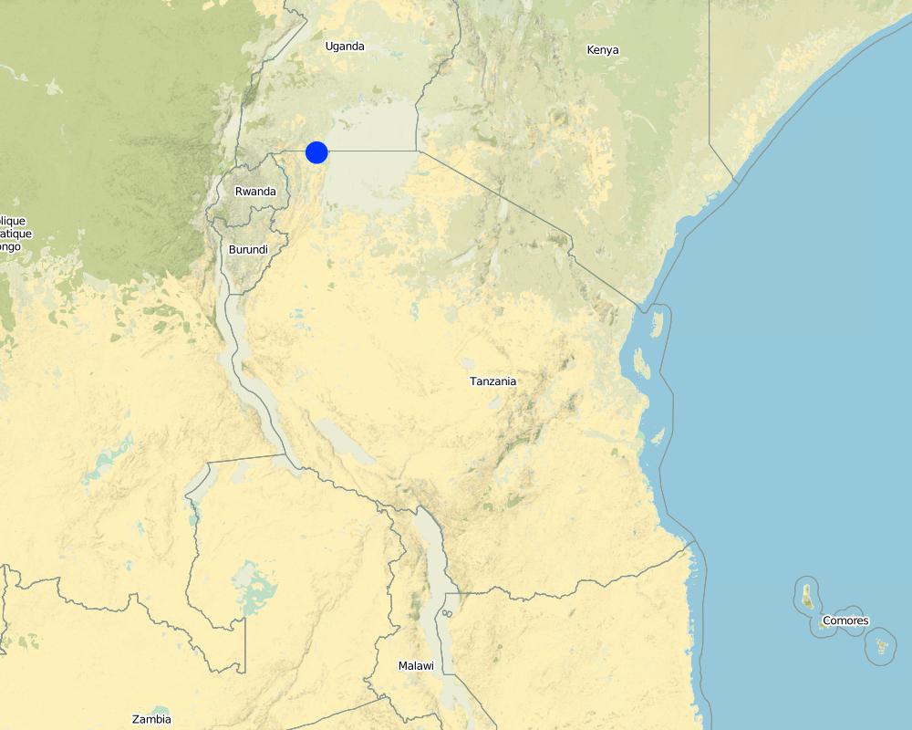
Map
×2.6 Date of implementation
If precise year is not known, indicate approximate date:
- more than 50 years ago (traditional)
2.7 Introduction of the Technology
Specify how the Technology was introduced:
- as part of a traditional system (> 50 years)
Comments (type of project, etc.):
the technology has been in use for about 80 years ago
3. Classification of the SLM Technology
3.2 Current land use type(s) where the Technology is applied
Land use mixed within the same land unit:
Yes
Specify mixed land use (crops/ grazing/ trees):
- Agro-pastoralism (incl. integrated crop-livestock)

Cropland
Number of growing seasons per year:
- 2
Specify:
Longest growing period in days: 120Longest growing period from month to month: September to DecemberSecond longest growing period in days: 90Second longest growing period from month to month: March to May

Grazing land
Extensive grazing:
- Semi-nomadic pastoralism
Animal type:
- cattle - dairy
- goats
- sheep

Forest/ woodlands
Comments:
Livestock density (if relevant):
10-25 LU /km2
Major land use problems (compiler’s opinion): Eutrophication, siltation, water shortage, deforestation and wildfire outbreaks
Major land use problems (land users’ perception): Drying of the underground water source.
Constraints of mines and extractive industries
Constraints of settlement / urban
Constraints of infrastructure network (roads, railways, pipe lines, power lines)
Constraints of wastelands / deserts / glaciers / swamps
Constraints of recreation
3.4 Water supply
Water supply for the land on which the Technology is applied:
- rainfed
3.6 SLM measures comprising the Technology

vegetative measures
- V1: Tree and shrub cover
- V2: Grasses and perennial herbaceous plants

structural measures
- S11: Others

management measures
- M7: Others
Comments:
Specification of other structural measures: water collection pond and animal watering trough
Specification of other management measures: protect water source enclosure by naturally regenerating vegetation
3.7 Main types of land degradation addressed by the Technology

physical soil deterioration
- Pc: compaction

biological degradation
- Bc: reduction of vegetation cover

water degradation
- Hp: decline of surface water quality
Comments:
Main causes of degradation: deforestation / removal of natural vegetation (incl. forest fires) (cutting of natural tree and removal of grass along the natural water flow way), overgrazing (Compaction by trampling animals, rainfall runoff, siltation of water collection point and disapearence of vegatative cover.), discharges (point contamination of water) (spoilage and contamination of surface water by human and livestock feaces.), population pressure (Overstocking due to increase in the number of livestock), poverty / wealth (low capacity to invest in enviromental friendly energy sources), inputs and infrastructure: (roads, markets, distribution of water points, other, …) (Unavailable improved and reliable water ponds and animal watering troughs), education, access to knowledge and support services (limited knowledge on sustainable use of natural water sources), governance / institutional (limited enforcement of existing environmental regulatory systems.)
Secondary causes of degradation: soil management (excavation and layout that contradict the natural environment), crop management (annual, perennial, tree/shrub), over-exploitation of vegetation for domestic use (fire wood collection from the natural water source), industrial activities and mining, urbanisation and infrastructure development, release of airborne pollutants (urban/industry…), disturbance of water cycle (infiltration / runoff), over abstraction / excessive withdrawal of water (for irrigation, industry, etc.), other human induced causes (specify), change in temperature, change of seasonal rainfall, Heavy / extreme rainfall (intensity/amounts), wind storms / dust storms, floods, droughts, other natural causes (avalanches, volcanic eruptions, mud flows, highly susceptible natural resources, extreme topography, etc.) specify, land tenure, labour availability, war and conflicts
3.8 Prevention, reduction, or restoration of land degradation
Specify the goal of the Technology with regard to land degradation:
- prevent land degradation
- restore/ rehabilitate severely degraded land
4. Technical specifications, implementation activities, inputs, and costs
4.1 Technical drawing of the Technology
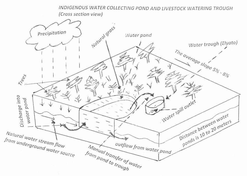
Technical specifications (related to technical drawing):
Water pond and water trough cross section view.
The water pond has an average internal capacity of size of 12m3 (4m length, 3m width and 1m depth).
Water troughs are constructed on the side of the water ponds. The water trough outside height is 0.2 - 0.4m above ground, inner depth is 0.5m, and diameter varies from 0.6 to 1m. It is made of cylindrical walls whose average width is 0.1m.
The average slope of the water catchment is 5% to 8%.
Location: Minziro village, Minziro ward, Missenyi division. Missenyi Dist, Kagera Reg, United Rep of Tanzania
Technical knowledge required for land users: moderate (At least primary school leaver with the basic indigenous technical knowledge.)
Main technical functions: control of dispersed runoff: retain / trap, control of concentrated runoff: retain / trap, water harvesting / increase water supply, improvement of water quality, buffering / filtering water
Secondary technical functions: improvement of ground cover, improvement of surface structure (crusting, sealing), stabilisation of soil (eg by tree roots against land slides), increase / maintain water stored in soil, increase of groundwater level / recharge of groundwater, water spreading, sediment retention / trapping, sediment harvesting, increase of biomass (quantity), control of fires, spatial arrangement and diversification of land use
Dam/ pan/ pond
Vertical interval between structures (m): 0
Spacing between structures (m): 10 to 20
Depth of ditches/pits/dams (m): 1
Width of ditches/pits/dams (m): 3
Length of ditches/pits/dams (m): 4
Height of bunds/banks/others (m): 0.3
Width of bunds/banks/others (m): 0.3
Length of bunds/banks/others (m): 4
Structural measure: water trough
Depth of ditches/pits/dams (m): 0.5
Width of ditches/pits/dams (m): 0.6 to 1
Length of ditches/pits/dams (m): 0.6 to 1
Height of bunds/banks/others (m): 0.2
Width of bunds/banks/others (m): 0.1
Length of bunds/banks/others (m): 0.6
Construction material (earth): mostry used clay soil and red termite mound soil.
Construction material (wood): for water pond and trough stabilization
Slope (which determines the spacing indicated above): 8%
If the original slope has changed as a result of the Technology, the slope today is: 8%
Lateral gradient along the structure: 5%
Specification of dams/ pans/ ponds: Capacity 10.6m3
Catchment area: 4 acresm2
For water harvesting: the ratio between the area where the harvested water is applied and the total area from which water is collected is: 1:4
Vegetation is used for stabilisation of structures.
Author:
Allan Bubelwa, Box 38 Kyaka Missenyi
Date:
28/8/2012
4.2 General information regarding the calculation of inputs and costs
other/ national currency (specify):
Tanzanian shillings
If relevant, indicate exchange rate from USD to local currency (e.g. 1 USD = 79.9 Brazilian Real): 1 USD =:
1600.0
Indicate average wage cost of hired labour per day:
3.13
4.3 Establishment activities
| Activity | Timing (season) | |
|---|---|---|
| 1. | Land preparation for pond excavation | During dry season |
| 2. | Construction of pond | During dry period |
| 3. | Construction of water trough | During dry season |
4.4 Costs and inputs needed for establishment
| Specify input | Unit | Quantity | Costs per Unit | Total costs per input | % of costs borne by land users | |
|---|---|---|---|---|---|---|
| Labour | Land preparation for pond excavation | person/day | 1.0 | 1.25 | 1.25 | 100.0 |
| Labour | Construction of pond | person/day | 1.0 | 21.88 | 21.88 | 100.0 |
| Labour | Construction of water trough | person/day | 1.0 | 3.13 | 3.13 | 100.0 |
| Equipment | Tools | piece | 1.0 | 3.13 | 3.13 | 100.0 |
| Equipment | Tools | piece | 3.0 | 9.38 | 28.14 | 100.0 |
| Construction material | Wood | pieces | 2.0 | 1.25 | 2.5 | 100.0 |
| Construction material | Earth | kg | 20.0 | 1.25 | 25.0 | 100.0 |
| Total costs for establishment of the Technology | 85.03 | |||||
| Total costs for establishment of the Technology in USD | 0.05 | |||||
Comments:
Duration of establishment phase: 1 month(s)
4.5 Maintenance/ recurrent activities
| Activity | Timing/ frequency | |
|---|---|---|
| 1. | Desiltation | During dry season |
| 2. | Wall and bank strengthening and repair (reshaping and grass slashing/gap filling) | During dry season |
| 3. | Water trough repairing | dry season |
| 4. | Filling to and emptying water from water trough and collection and application of red termite mound soil. |
4.6 Costs and inputs needed for maintenance/ recurrent activities (per year)
| Specify input | Unit | Quantity | Costs per Unit | Total costs per input | % of costs borne by land users | |
|---|---|---|---|---|---|---|
| Labour | Desiltation | person days | 5.0 | 6.25 | 31.25 | 100.0 |
| Labour | Wall and bank strengthening and repair (reshaping and grass slashing/gap filling) | person days | 5.0 | 6.25 | 31.25 | 100.0 |
| Labour | Water trough repairing | person days | 8.0 | 10.0 | 80.0 | 100.0 |
| Labour | Filling to and emptying water from water trough and collection and application of red termite mound soil. | person days | 450.0 | 1.25 | 562.5 | 100.0 |
| Equipment | Tools | pieces | 2.0 | 5.0 | 10.0 | 100.0 |
| Equipment | Water can | pieces | 2.0 | 1.88 | 3.76 | 100.0 |
| Construction material | Wood | pieces | 6.0 | 3.75 | 22.5 | 100.0 |
| Construction material | Earth | kg | 60.0 | 3.75 | 225.0 | 100.0 |
| Total costs for maintenance of the Technology | 966.26 | |||||
| Total costs for maintenance of the Technology in USD | 0.6 | |||||
Comments:
The cost is calculated per one water pond and its one trough and as per 28 August 2012
4.7 Most important factors affecting the costs
Describe the most determinate factors affecting the costs:
Labour is the most determinant factor affecting the costs
5. Natural and human environment
5.1 Climate
Annual rainfall
- < 250 mm
- 251-500 mm
- 501-750 mm
- 751-1,000 mm
- 1,001-1,500 mm
- 1,501-2,000 mm
- 2,001-3,000 mm
- 3,001-4,000 mm
- > 4,000 mm
Agro-climatic zone
- humid
- sub-humid
Thermal climate class: tropics. all months temperature is above 18
Thermal climate class: subtropics
Thermal climate class: temperate
Thermal climate class: boreal
Thermal climate class: polar/arctic
5.2 Topography
Slopes on average:
- flat (0-2%)
- gentle (3-5%)
- moderate (6-10%)
- rolling (11-15%)
- hilly (16-30%)
- steep (31-60%)
- very steep (>60%)
Landforms:
- plateau/plains
- ridges
- mountain slopes
- hill slopes
- footslopes
- valley floors
Altitudinal zone:
- 0-100 m a.s.l.
- 101-500 m a.s.l.
- 501-1,000 m a.s.l.
- 1,001-1,500 m a.s.l.
- 1,501-2,000 m a.s.l.
- 2,001-2,500 m a.s.l.
- 2,501-3,000 m a.s.l.
- 3,001-4,000 m a.s.l.
- > 4,000 m a.s.l.
5.3 Soils
Soil depth on average:
- very shallow (0-20 cm)
- shallow (21-50 cm)
- moderately deep (51-80 cm)
- deep (81-120 cm)
- very deep (> 120 cm)
Soil texture (topsoil):
- fine/ heavy (clay)
Topsoil organic matter:
- medium (1-3%)
- low (<1%)
5.4 Water availability and quality
Ground water table:
on surface
Availability of surface water:
good
Water quality (untreated):
good drinking water
5.6 Characteristics of land users applying the Technology
Market orientation of production system:
- mixed (subsistence/ commercial)
Relative level of wealth:
- average
Individuals or groups:
- individual/ household
Gender:
- women
- men
Indicate other relevant characteristics of the land users:
Difference in the involvement of women and men: little involvement of women because at large/traditionally livestock rearing is done by men.
Population density: 50-100 persons/km2
Annual population growth: 2% - 3%
5% of the land users are rich and own 5% of the land.
10% of the land users are average wealthy and own 35% of the land (the techology is used by rich and average livestock keepers who have the animal).
75% of the land users are poor and own 40% of the land (the village poors usually do not have the animals though most of them are cattle herders).
10% of the land users are poor and own 20% of the land.
5.7 Average area of land used by land users applying the Technology
- < 0.5 ha
- 0.5-1 ha
- 1-2 ha
- 2-5 ha
- 5-15 ha
- 15-50 ha
- 50-100 ha
- 100-500 ha
- 500-1,000 ha
- 1,000-10,000 ha
- > 10,000 ha
Is this considered small-, medium- or large-scale (referring to local context)?
- small-scale
5.8 Land ownership, land use rights, and water use rights
Land ownership:
- communal/ village
- individual, not titled
Land use rights:
- individual
Water use rights:
- communal (organized)
- individual
5.9 Access to services and infrastructure
health:
- poor
- moderate
- good
education:
- poor
- moderate
- good
technical assistance:
- poor
- moderate
- good
employment (e.g. off-farm):
- poor
- moderate
- good
markets:
- poor
- moderate
- good
roads and transport:
- poor
- moderate
- good
drinking water and sanitation:
- poor
- moderate
- good
6. Impacts and concluding statements
6.1 On-site impacts the Technology has shown
Socio-economic impacts
Production
animal production
product diversity
energy generation
Water availability and quality
drinking water availability
Income and costs
diversity of income sources
economic disparities
Socio-cultural impacts
community institutions
national institutions
SLM/ land degradation knowledge
Ecological impacts
Water cycle/ runoff
water quantity
water quality
harvesting/ collection of water
surface runoff
groundwater table/ aquifer
evaporation
Soil
soil moisture
nutrient cycling/ recharge
Biodiversity: vegetation, animals
biomass/ above ground C
habitat diversity
pest/ disease control
Climate and disaster risk reduction
emission of carbon and greenhouse gases
fire risk
wind velocity
6.2 Off-site impacts the Technology has shown
reliable and stable stream flows in dry season
downstream flooding
buffering/ filtering capacity
damage on neighbours' fields
6.3 Exposure and sensitivity of the Technology to gradual climate change and climate-related extremes/ disasters (as perceived by land users)
Gradual climate change
Gradual climate change
| Season | increase or decrease | How does the Technology cope with it? | |
|---|---|---|---|
| annual temperature | increase | well |
Climate-related extremes (disasters)
Meteorological disasters
| How does the Technology cope with it? | |
|---|---|
| local rainstorm | not well |
| local windstorm | well |
Climatological disasters
| How does the Technology cope with it? | |
|---|---|
| drought | well |
Hydrological disasters
| How does the Technology cope with it? | |
|---|---|
| general (river) flood | not well |
Other climate-related consequences
Other climate-related consequences
| How does the Technology cope with it? | |
|---|---|
| reduced growing period | not known |
Comments:
Improving structure on the pond (use impermeable materials to prevent seepage, use concrete as a building material)
6.4 Cost-benefit analysis
How do the benefits compare with the establishment costs (from land users’ perspective)?
Short-term returns:
positive
Long-term returns:
positive
How do the benefits compare with the maintenance/ recurrent costs (from land users' perspective)?
Short-term returns:
positive
Long-term returns:
positive
Comments:
The technology requires low establishment and maintenance cost and benefit surpass the costs.
6.5 Adoption of the Technology
Of all those who have adopted the Technology, how many did so spontaneously, i.e. without receiving any material incentives/ payments?
- 11-50%
Comments:
12% of land user families have adopted the Technology without any external material support
250 land user families have adopted the Technology without any external material support
All livestock keepers use the technology to water their animals voluntary and through self mobilization.
There is a moderate trend towards spontaneous adoption of the Technology
The technology is cheap and requires low investment costs.
6.7 Strengths/ advantages/ opportunities of the Technology
| Strengths/ advantages/ opportunities in the land user’s view |
|---|
|
Income generation due to water use fee. How can they be sustained / enhanced? improve service to water users. . |
| Strengths/ advantages/ opportunities in the compiler’s or other key resource person’s view |
|---|
|
Reduce conflict between livestock keepers and domestic water users. How can they be sustained / enhanced? Bylaws reinforcement, Area enclosure and Demarcation |
|
Improve accessibility of water to animals (improved animal water intake) How can they be sustained / enhanced? sensitization on regular maintenance. |
6.8 Weaknesses/ disadvantages/ risks of the Technology and ways of overcoming them
| Weaknesses/ disadvantages/ risks in the land user’s view | How can they be overcome? |
|---|---|
| Not durable and requires frequent and regular maintenance | Sensitize on regular maintenance. |
| Weaknesses/ disadvantages/ risks in the compiler’s or other key resource person’s view | How can they be overcome? |
|---|---|
| not durable | Sensitize on regular maintenance. |
| high labor demand to fill the troughs | Use simple leverage pump |
7. References and links
7.1 Methods/ sources of information
7.2 References to available publications
Title, author, year, ISBN:
Kagera TAMP project website
Available from where? Costs?
http://www.fao.org/nr/kagera/en/
Links and modules
Expand all Collapse allLinks
No links
Modules
No modules