Rangeland Improvement in Savanah with High Livestocks [Tanzania, United Republic of]
- Creation:
- Update:
- Compiler: Jasson Rwazo
- Editor: –
- Reviewers: Deborah Niggli, Alexandra Gavilano
Uboreshaji wa Nyanda za malisho katika uoto wa asili wa savana wenye ng'ombe wengi.
technologies_1314 - Tanzania, United Republic of
View sections
Expand all Collapse all1. General information
1.2 Contact details of resource persons and institutions involved in the assessment and documentation of the Technology
SLM specialist:
Poder Alexander
Name of the institution(s) which facilitated the documentation/ evaluation of the Technology (if relevant)
Missenyi District Council (Missenyi District Council) - Tanzania, United Republic of1.3 Conditions regarding the use of data documented through WOCAT
The compiler and key resource person(s) accept the conditions regarding the use of data documented through WOCAT:
Yes
1.4 Declaration on sustainability of the described Technology
Is the Technology described here problematic with regard to land degradation, so that it cannot be declared a sustainable land management technology?
No
2. Description of the SLM Technology
2.1 Short description of the Technology
Definition of the Technology:
Improvement of degraded rangeland in savannah using multiple rangeland improvement techniques that complement each other to optimize livestock production and productivity sustainably.
2.2 Detailed description of the Technology
Description:
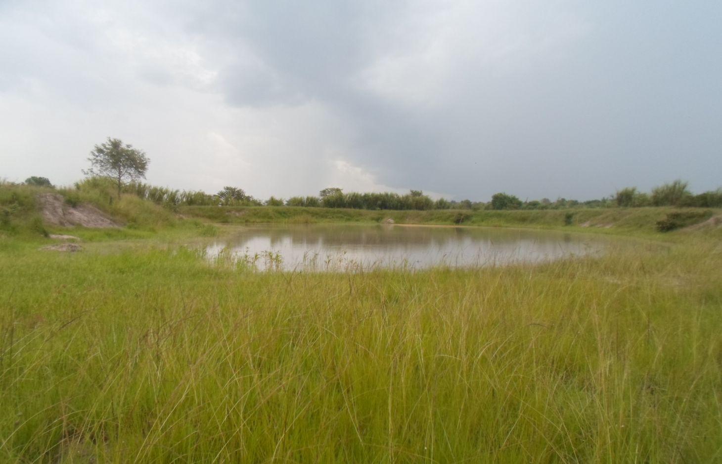
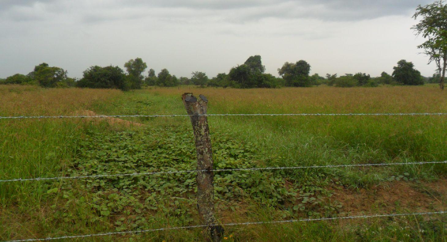
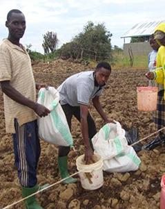
Multiple rangeland and pasture improvement techniques that combines water harvesting, rangeland reseeding and pasture establishment, livestock breeding management techniques to restore degraded rangeland in savannah with high livestock and optimize livestock production and productivity sustainably. These includes; 1. Chaco dam excavation for rain runoff harvesting mainly during the rainy season (February to April and August to December) mostly;(i).To ensure year round availability of water largely for watering livestock and partly for domestic and agriculture use especially during the main dry season when local sources (Ponds, springs or stream) are dry,(ii).To reduce soil erosion by water (lily or gully erosion, (iii).To reduce river bank erosion and silitation due direct watering of livestock in to Kagera river, (iii). To reduce the distance animal has to walk for watering and (iv) to reduce water use conflicts between herders and other land users. 2. Establishment of pasture demonstration plots where farmers are exposed to a basket choice (Low cost technique Vs high cost technique) of pasture and rangeland improvement technique either through ;( a). Tilling the land and broadcasting drought tolerant indigenous degenerated palatable pasture species of high nutritive value and, mainly (i).Grass; Cenchrus cliaris, Chloris gayana and (ii).Legumes; Centrocema puberse, Lablab purpureus, Mucuna Pluriens and Puperaria Phaseilides ) to a manured degraded rangeland; (b).i. Encouraging re-growth of proper pasture species in a degraded area to take place through clearing bushes, shrubs or trees ( leaving edible shrubs and few selected shed trees especially acacia spp which allow pasture re-growth underneath and provide shed against intense sun radiations to livestock especially during the main dry season- July to September); ii. Closing the degraded area by fencing using live indigenous trees or using wooden pole with or without barbed wire for 2 -3 years, removal of anthills and discouraging regeneration of unproductive invasive species and hence returning the rangeland to productivity;3. Genetical improvement of local cattle (Ankole or Zebu) through crossbreeding with introduced improved bull especially boran, Frisian or Mpwapwa bulls to allow farmers to keep few improved offspring of high production and productivity ;4.Farmer training on rangeland improvement and grazing management including hay making and how to estimate carrying capacity 5. Establishment of livestock markets directly on the rangeland to encourage off take and hence control stocking rate and increase carrying capacity.
Purpose:To contribute to the increase of herders’ standard of living through increased livestock production and productivity while conserving the environment
Estblishment activities:1. Community mobilization and formation of project management commetee with 10 members; 2. Identification of project sites; 3. Land clearing; 4. Establishment of pasture demonstration plots; 5. Excavation of chacodam and construction of watering troughs; 6. Fencing of individual owned land using wooden pole with barbed wire or live fencing using euphobia spp; 7. Farmer training on pasture establishment and controll of stocking rate; 8. Procurement of bulls (Boran or Mpwapwa) for cross breeding with ankole females; 9. Construction of livestock market
Maintanence Activities: 1. Repair of livestock infrastructures (Chacodam, watering troughs, livestock fence, livestock markets).
The technology is implemented in extensive grazing land under semi arid condition receiving 600 -1000mm of rains per year. A combination of rangeland improvement measures (Excavation of chacodam for rainwater runoff harvesting, pasture improvement and establishment techniques, fencing and breeding management through cross breeding local cow (Ankole/zebu) with Boran/Mpwapwa bulls) complement each other to restore degraded rangeland and increase livestock production and productivity in savannah. The slope is gentle to moderate; soil depth is shallow and soil texture clay. Heavy tools (Bulldozer) to Simple hand tools are traditional used. Bulldozers are used during chacodam excavation and bush clearing by well-off herder will small hand tools such as hand hoe, bush knife and spade are used smallholder herders for excavation of water pond and construction of indigenous livestock watering points. Land ownership is Communal/village, individual titled and individual not titled. Water use rights is open access (unorganized), communal (organized). Application of this technology determined by high establishment costs.
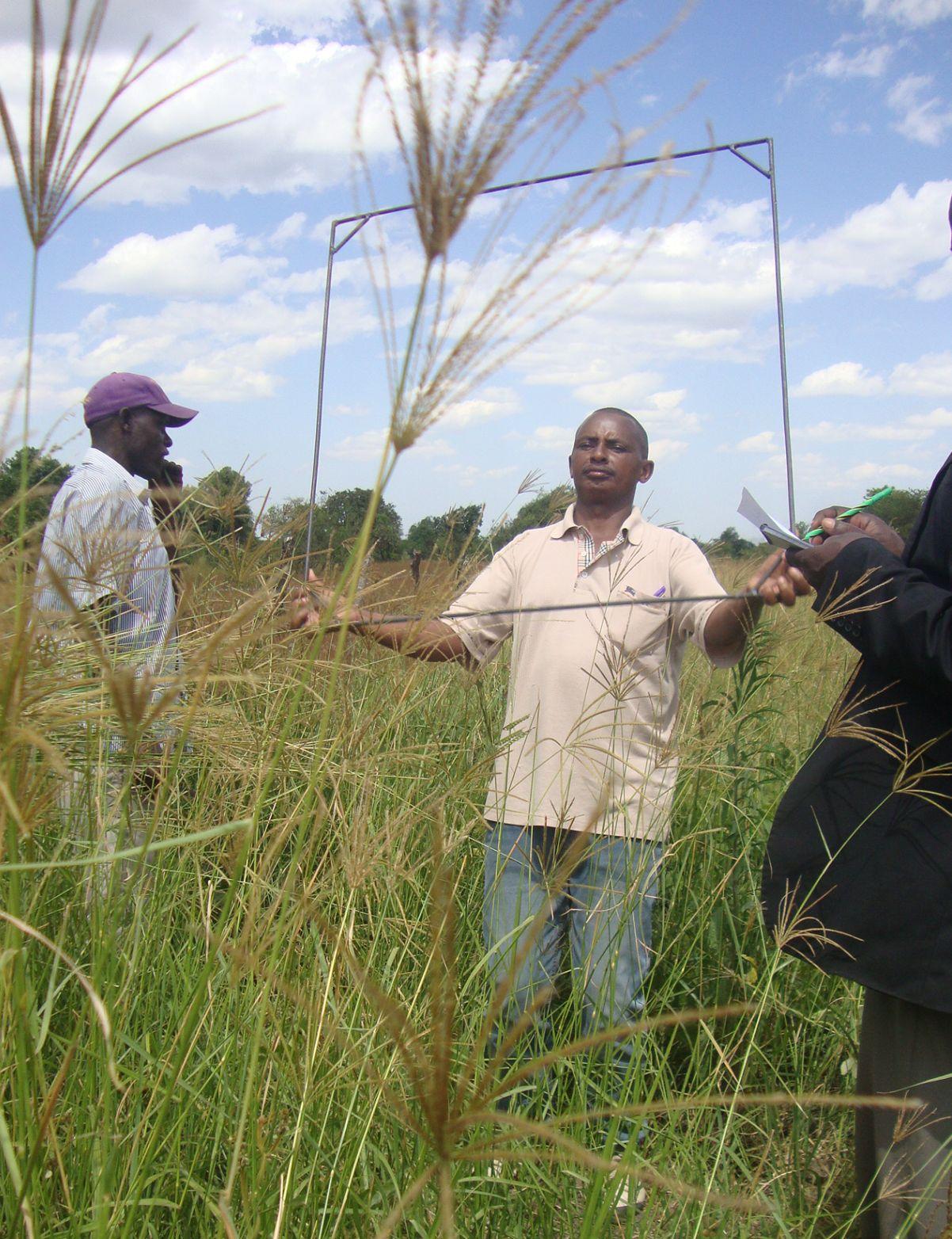
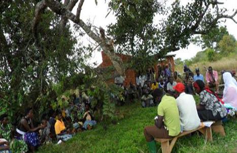
2.3 Photos of the Technology
Media Gallery
2.5 Country/ region/ locations where the Technology has been applied and which are covered by this assessment
Country:
Tanzania, United Republic of
Region/ State/ Province:
Kagera
Further specification of location:
Missenyi, Tanzania
Specify the spread of the Technology:
- evenly spread over an area
If precise area is not known, indicate approximate area covered:
- 1-10 km2
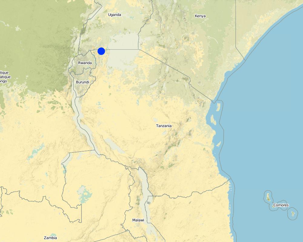
Map
×2.6 Date of implementation
If precise year is not known, indicate approximate date:
- less than 10 years ago (recently)
2.7 Introduction of the Technology
Specify how the Technology was introduced:
- through projects/ external interventions
3. Classification of the SLM Technology
3.1 Main purpose(s) of the Technology
- improve production
- reduce, prevent, restore land degradation
3.2 Current land use type(s) where the Technology is applied

Cropland
- Tree and shrub cropping

Grazing land
Extensive grazing:
- Semi-nomadic pastoralism
Animal type:
- cattle - non-dairy working
- Ankole, Zebu
Comments:
Livestock density (if relevant):
> 100 LU /km2
Major land use problems (compiler’s opinion): Major land use problem without conservation includes, overgrazing, soil erosion, siltation of water bodies (Kagera River) and loss of paratable pasture spp.
Major land use problems (land users’ perception): Shortage of pasture and water for livestock
3.3 Has land use changed due to the implementation of the Technology?
Grazing land
Extensive grazing:
- Semi-nomadic pastoralism
Comments:
Grazing land: Extensive grazing land
3.4 Water supply
Water supply for the land on which the Technology is applied:
- rainfed
Comments:
Number of growing seasons per year:
2
3.5 SLM group to which the Technology belongs
- pastoralism and grazing land management
3.6 SLM measures comprising the Technology

agronomic measures
- A1: Vegetation/ soil cover
- A7: Others

vegetative measures
- V3: Clearing of vegetation
- V5: Others

structural measures
- S5: Dams, pans, ponds

management measures
- M1: Change of land use type
- M2: Change of management/ intensity level
- M5: Control/ change of species composition
Comments:
Type of agronomic measures: legume inter-planting, manure / compost / residues
Type of vegetative measures: in blocks
3.7 Main types of land degradation addressed by the Technology

soil erosion by water
- Wg: gully erosion/ gullying

soil erosion by wind
- Et: loss of topsoil

physical soil deterioration
- Pc: compaction

biological degradation
- Bc: reduction of vegetation cover
- Bq: quantity/ biomass decline
Comments:
Main causes of degradation: overgrazing (Overgrazing due overstocking due to illegal migration on livestock), change in temperature (increased average temperature from 20.9o to 21.5oC in the past 20 years), Heavy / extreme rainfall (intensity/amounts) (decreased average annual rainfall from 1000mm to 870mm in the past 20 years), droughts, land tenure (Lack of village land use plan), inputs and infrastructure: (roads, markets, distribution of water points, other, …)
Secondary causes of degradation: deforestation / removal of natural vegetation (incl. forest fires) (Uncontrolled bush fire set purposely to remove overgrown bushes), disturbance of water cycle (infiltration / runoff), change of seasonal rainfall, population pressure (In migration of people from neighbourig districts and countries), education, access to knowledge and support services
3.8 Prevention, reduction, or restoration of land degradation
Specify the goal of the Technology with regard to land degradation:
- reduce land degradation
4. Technical specifications, implementation activities, inputs, and costs
4.1 Technical drawing of the Technology
Technical specifications (related to technical drawing):
Location: Bubale Village. Missenyi District/Kagera
Technical knowledge required for field staff / advisors: high
Technical knowledge required for land users: high
Main technical functions: improvement of ground cover, increase in organic matter, water harvesting / increase water supply, promotion of vegetation species and varieties (quality, eg palatable fodder)
Secondary technical functions: control of raindrop splash, control of concentrated runoff: retain / trap, improvement of topsoil structure (compaction), stabilisation of soil (eg by tree roots against land slides), increase / maintain water stored in soil
Legume inter-planting
Remarks: Legumes are inter-planted with grass to increase the nutritive value of the pasture
Manure / compost / residues
Material/ species: Farmyard manure
Quantity/ density: 60t/Ha
In blocks
Vegetative material: G : grass, O : other
Grass species: Cenchrus cliaris, Chloris gayana, elephant grass,
Other species: Legumes:Centrocema puberse, Lablab purpureus, Mucuna Pluriens and Puperaria Phaseilides
Dam/ pan/ pond
Depth of ditches/pits/dams (m): 2.3
Width of ditches/pits/dams (m): 40
Length of ditches/pits/dams (m): 80
Height of bunds/banks/others (m): 6
Width of bunds/banks/others (m): 4
Length of bunds/banks/others (m): 240
Structural measure: Water trough
Depth of ditches/pits/dams (m): 2.5
Width of ditches/pits/dams (m): 1
Length of ditches/pits/dams (m): 21
Structural measure: Appron
Depth of ditches/pits/dams (m): 3
Width of ditches/pits/dams (m): 0.3
Length of ditches/pits/dams (m): 27
Construction material (earth): Clay soil
Construction material (concrete): concrete
Vegetation is used for stabilisation of structures.
Control / change of species composition: Crossbreeding local female cattle(Ankole or Zebu) with boran or mpwapwa bulls
Other type of management: Closing the degraded area by fencing using pole or live indigenous trees with or without barbed wire for 2 -3 years, removal of anthills and discouraging regeneration of unproductive invasive species.
Author:
Jasson Rwazo, P.O.BOX 38, Missenyi Tanzania,email: Wazo12375@yahoo.co.uk
4.2 General information regarding the calculation of inputs and costs
other/ national currency (specify):
Tanzanian Shilling
If relevant, indicate exchange rate from USD to local currency (e.g. 1 USD = 79.9 Brazilian Real): 1 USD =:
2186.41
Indicate average wage cost of hired labour per day:
6.86
4.3 Establishment activities
| Activity | Timing (season) | |
|---|---|---|
| 1. | Procurement of 6 Boran/Mpwapwa bulls | |
| 2. | Transportation of bulls from Dodoma | |
| 3. | Vaccination against East Cost fever (ECF) | |
| 4. | Fencing | Procument Barbed wire |
| 5. | Excavation of water chaco dam | During the dry season |
| 6. | Fence construction | During the dry season |
| 7. | Construction of livestock market | |
| 8. | Land preparation | Eary June to september |
| 9. | Manure application | Mid september to early november |
| 10. | Planting | Early octobar |
4.4 Costs and inputs needed for establishment
| Specify input | Unit | Quantity | Costs per Unit | Total costs per input | % of costs borne by land users | |
|---|---|---|---|---|---|---|
| Labour | labour | ha | 1.0 | 810.93 | 810.93 | |
| Equipment | tools | ha | 1.0 | 34.0 | 34.0 | |
| Plant material | seeds | ha | 1.0 | 1204.0 | 1204.0 | |
| Fertilizers and biocides | compost/manure | ha | 1.0 | 274.42 | 274.42 | 20.0 |
| Construction material | Chacodam Excavation | ha | 1.0 | 16007.0 | 16007.0 | 20.0 |
| Construction material | Const livestock makert | ha | 1.0 | 12577.0 | 12577.0 | 20.0 |
| Other | Procument of 6 bulls | ha | 1.0 | 548.84 | 548.84 | 20.0 |
| Other | Vaccination | ha | 1.0 | 54.88 | 54.88 | |
| Other | Fencing | ha | 1.0 | 1957.7 | 1957.7 | |
| Total costs for establishment of the Technology | 33468.77 | |||||
| Total costs for establishment of the Technology in USD | 15.31 | |||||
Comments:
Duration of establishment phase: 36 month(s)
4.5 Maintenance/ recurrent activities
| Activity | Timing/ frequency | |
|---|---|---|
| 1. | Repair of the fence | Once per year |
| 2. | Weeding and bush thinning | 0nce per year |
| 3. | Construction of fire break | Once per year |
| 4. | Harvesting pasture seeds | Once per year |
4.6 Costs and inputs needed for maintenance/ recurrent activities (per year)
| Specify input | Unit | Quantity | Costs per Unit | Total costs per input | % of costs borne by land users | |
|---|---|---|---|---|---|---|
| Labour | labour | ha | 1.0 | 205.34 | 205.34 | 20.0 |
| Equipment | tools | ha | 1.0 | 34.0 | 34.0 | |
| Total costs for maintenance of the Technology | 239.34 | |||||
| Total costs for maintenance of the Technology in USD | 0.11 | |||||
Comments:
Machinery/ tools: Hand hoe, bush knife, Bulldozer, handhooe, spade, truck, Hand hoe, hamer, nails, woods
4.7 Most important factors affecting the costs
Describe the most determinate factors affecting the costs:
Excavation of chacodam, fencing and procurement of breeding bulls
5. Natural and human environment
5.1 Climate
Annual rainfall
- < 250 mm
- 251-500 mm
- 501-750 mm
- 751-1,000 mm
- 1,001-1,500 mm
- 1,501-2,000 mm
- 2,001-3,000 mm
- 3,001-4,000 mm
- > 4,000 mm
Agro-climatic zone
- semi-arid
Thermal climate class: tropics
5.2 Topography
Slopes on average:
- flat (0-2%)
- gentle (3-5%)
- moderate (6-10%)
- rolling (11-15%)
- hilly (16-30%)
- steep (31-60%)
- very steep (>60%)
Landforms:
- plateau/plains
- ridges
- mountain slopes
- hill slopes
- footslopes
- valley floors
Altitudinal zone:
- 0-100 m a.s.l.
- 101-500 m a.s.l.
- 501-1,000 m a.s.l.
- 1,001-1,500 m a.s.l.
- 1,501-2,000 m a.s.l.
- 2,001-2,500 m a.s.l.
- 2,501-3,000 m a.s.l.
- 3,001-4,000 m a.s.l.
- > 4,000 m a.s.l.
5.3 Soils
Soil depth on average:
- very shallow (0-20 cm)
- shallow (21-50 cm)
- moderately deep (51-80 cm)
- deep (81-120 cm)
- very deep (> 120 cm)
Soil texture (topsoil):
- fine/ heavy (clay)
Topsoil organic matter:
- medium (1-3%)
5.4 Water availability and quality
Ground water table:
> 50 m
Availability of surface water:
medium
Water quality (untreated):
poor drinking water (treatment required)
5.5 Biodiversity
Species diversity:
- medium
5.6 Characteristics of land users applying the Technology
Market orientation of production system:
- subsistence (self-supply)
- commercial/ market
Off-farm income:
- less than 10% of all income
Relative level of wealth:
- rich
- very rich
Individuals or groups:
- groups/ community
Gender:
- men
Indicate other relevant characteristics of the land users:
Land users applying the Technology are mainly common / average land users
Population density: 10-50 persons/km2
5% of the land users are very rich and own 50% of the land.
35% of the land users are rich and own 25% of the land.
55% of the land users are average wealthy and own 10% of the land.
5.7 Average area of land used by land users applying the Technology
- < 0.5 ha
- 0.5-1 ha
- 1-2 ha
- 2-5 ha
- 5-15 ha
- 15-50 ha
- 50-100 ha
- 100-500 ha
- 500-1,000 ha
- 1,000-10,000 ha
- > 10,000 ha
Is this considered small-, medium- or large-scale (referring to local context)?
- small-scale
5.8 Land ownership, land use rights, and water use rights
Land ownership:
- communal/ village
- individual, not titled
5.9 Access to services and infrastructure
health:
- poor
- moderate
- good
education:
- poor
- moderate
- good
technical assistance:
- poor
- moderate
- good
employment (e.g. off-farm):
- poor
- moderate
- good
markets:
- poor
- moderate
- good
energy:
- poor
- moderate
- good
roads and transport:
- poor
- moderate
- good
drinking water and sanitation:
- poor
- moderate
- good
financial services:
- poor
- moderate
- good
6. Impacts and concluding statements
6.1 On-site impacts the Technology has shown
Socio-economic impacts
Production
crop production
fodder production
fodder quality
animal production
wood production
Water availability and quality
drinking water availability
Income and costs
farm income
Socio-cultural impacts
food security/ self-sufficiency
health situation
community institutions
SLM/ land degradation knowledge
conflict mitigation
contribution to human well-being
Comments/ specify:
Grazing management and conservation knowledge
Ecological impacts
Water cycle/ runoff
water quantity
harvesting/ collection of water
Soil
soil cover
soil compaction
Climate and disaster risk reduction
fire risk
6.2 Off-site impacts the Technology has shown
water availability
downstream siltation
damage on neighbours' fields
6.3 Exposure and sensitivity of the Technology to gradual climate change and climate-related extremes/ disasters (as perceived by land users)
Climate-related extremes (disasters)
Meteorological disasters
| How does the Technology cope with it? | |
|---|---|
| local windstorm | well |
Climatological disasters
| How does the Technology cope with it? | |
|---|---|
| drought | well |
Comments:
Construction of chaco dam for water harvesting during the wet season to be used during the dry season, planting drought tolerant pasture sp
6.4 Cost-benefit analysis
How do the benefits compare with the establishment costs (from land users’ perspective)?
Short-term returns:
slightly positive
Long-term returns:
very positive
How do the benefits compare with the maintenance/ recurrent costs (from land users' perspective)?
Short-term returns:
positive
Long-term returns:
very positive
6.5 Adoption of the Technology
Comments:
50 land user families have adopted the Technology without any external material support
There is a strong trend towards spontaneous adoption of the Technology
6.7 Strengths/ advantages/ opportunities of the Technology
| Strengths/ advantages/ opportunities in the land user’s view |
|---|
| Increased livestock production(Milk and Meat) |
| Increased farm income |
| Strengths/ advantages/ opportunities in the compiler’s or other key resource person’s view |
|---|
| Increased water availability for livestock and domestic use |
| Increased pasture availability for livestock |
| Increased conservation knowledge |
| Increased livestock production and productivity |
6.8 Weaknesses/ disadvantages/ risks of the Technology and ways of overcoming them
| Weaknesses/ disadvantages/ risks in the compiler’s or other key resource person’s view | How can they be overcome? |
|---|---|
| High fire risk | Strengthener fire control bylaw, control burning and use of fire break |
7. References and links
7.1 Methods/ sources of information
- field visits, field surveys
- interviews with land users
When were the data compiled (in the field)?
04/12/2015
Links and modules
Expand all Collapse allLinks
No links
Modules
No modules