Reafforestation of Tugai floodplain ecosystem [Tajikistan]
- Creation:
- Update:
- Compiler: Rustam Nugmanov
- Editor: –
- Reviewers: Fabian Ottiger, Alexandra Gavilano
technologies_1509 - Tajikistan
View sections
Expand all Collapse all1. General information
1.2 Contact details of resource persons and institutions involved in the assessment and documentation of the Technology
SLM specialist:
Nickalls Tom
ACTED
Tajikistan
Name of the institution(s) which facilitated the documentation/ evaluation of the Technology (if relevant)
Agency for Technical Cooperation and Development Tajikistan (ACTED Tajikistan) - Tajikistan1.3 Conditions regarding the use of data documented through WOCAT
The compiler and key resource person(s) accept the conditions regarding the use of data documented through WOCAT:
Yes
1.4 Declaration on sustainability of the described Technology
Is the Technology described here problematic with regard to land degradation, so that it cannot be declared a sustainable land management technology?
No
2. Description of the SLM Technology
2.1 Short description of the Technology
Definition of the Technology:
Reforestation of the Tugai floodplain ecosystem with reed stands, poplars, djigda, and tamarisk thickets to strengthen the river bank area along the Pyanj river.
2.2 Detailed description of the Technology
Description:
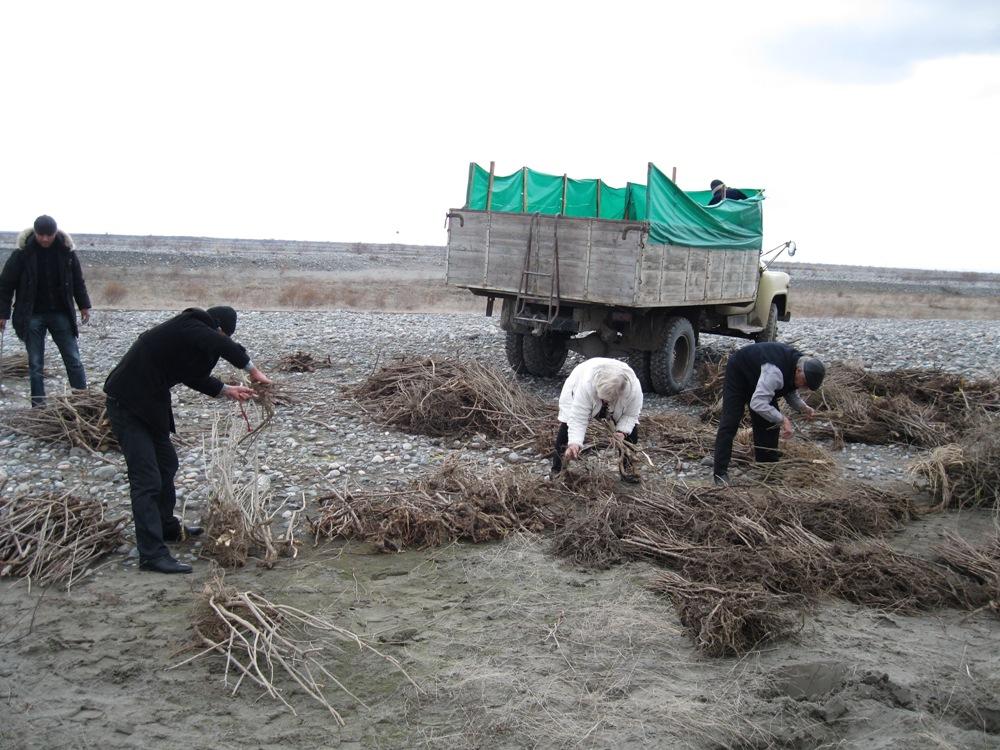
Reforestation works are being carried out in an area of 18.2 km2 in four demarcated zones each measuring 4.55 km2. ACTED and CAREC have entered into labour agreements with household representatives of villages near the riparian area to carry out the plantation of seedlings and bushes. 520 household representatives will plant a variety of 150,000 seedlings and bushes in the floodplain area (prone to flooding).
Reforestation works will help to reinforce the river bank area and protect it against potentially large scale floods. It will also diminish the effect of river bank erosion caused by flood waters. The activity will also protect the natural ecosystem in the target area and provide greater security for both the animal and human habitat. As a secondary purpose the reforestation works will also encourage local communities to be more aware of, and to hopefully motivate them to address some of the serious environmental and socio-economical problems affecting them.
The area was preselected by an expert as an area that was a degraded Tugai floodplain forest ecosystem. The area was assessed to ensure it still maintained a Tugai ecosystem. The extensive area was broken into smaller manageable parts of 3.5 h.a., these areas were then allocated to Jamoats who then further reassigned the responsibility to households. The next step is the development of a planting plan and schedule that includes fruit trees, timber and thickets.
The seedlings are obtained from the National Park area in collaboration with the state forestry department. The households are taught basic planting techniques, and supervised during the planting from November to March. A maintenance plan was established to ensure the upkeep of the ecosystem including watering, composting, and pruning.
The issue was that the Pyanj river was encroaching towards villages and cultivated lands that are essential to the livelihood of the local inhabitants. There is a lack of natural resources and increasing pressure on the available land for subsistence farming.
2.3 Photos of the Technology
Media Gallery
2.5 Country/ region/ locations where the Technology has been applied and which are covered by this assessment
Country:
Tajikistan
Region/ State/ Province:
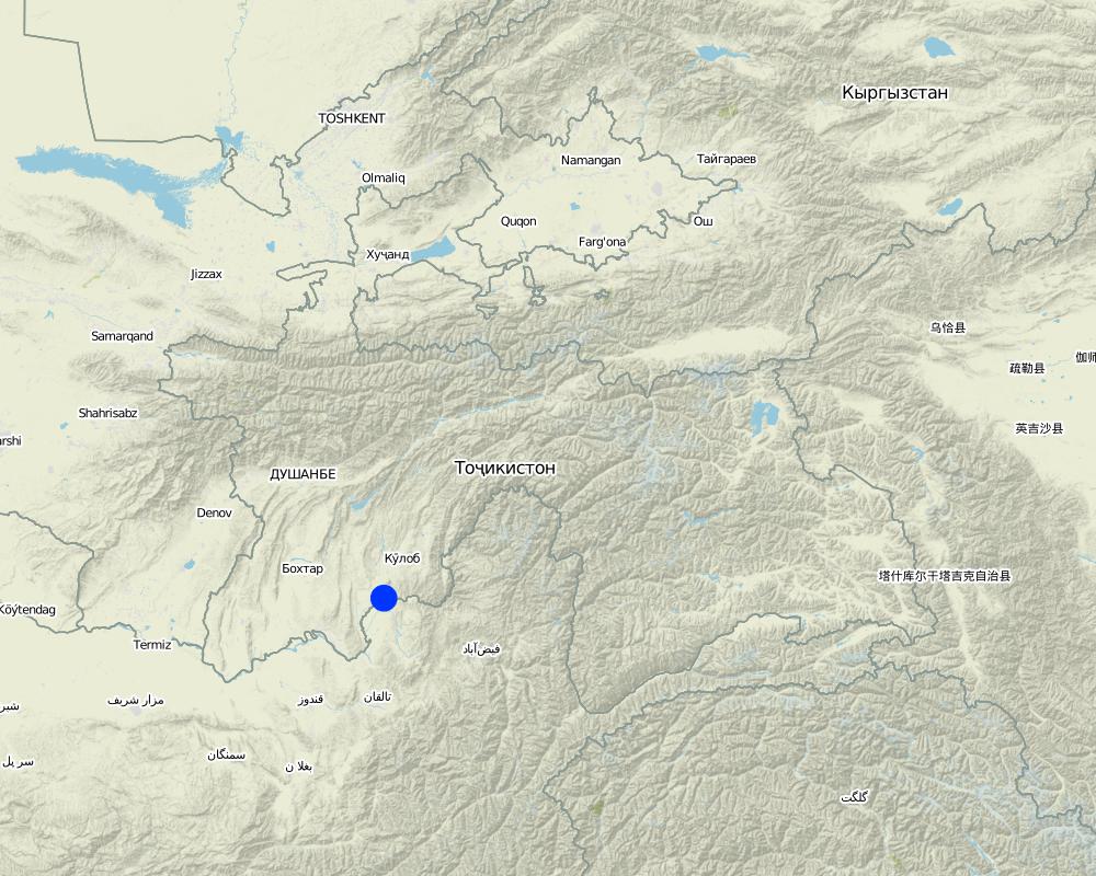
Khatlon
Further specification of location:
MSA Hamadoni
Comments:
Specify the spread of the Technology:
evenly spread over an area
If the Technology is evenly spread over an area, indicate approximate area covered:
1-10 km2
Comments:
Total area covered by the SLM Technology is 4 km2.
The Vakil (village representant) was not sure about the area, between 300 to 500 ha.
Total area covered by the SLM Technology is 18.2 km2.
Map
×2.6 Date of implementation
If precise year is not known, indicate approximate date:
- less than 10 years ago (recently)
2.7 Introduction of the Technology
Specify how the Technology was introduced:
- through projects/ external interventions
Comments (type of project, etc.):
In 2008 the Asian Development Bank did their initial appraisal of the Tugai ecosystem.
3. Classification of the SLM Technology
3.1 Main purpose(s) of the Technology
- reduce, prevent, restore land degradation
- conserve ecosystem
- preserve/ improve biodiversity
3.2 Current land use type(s) where the Technology is applied

Forest/ woodlands
- Poor natural Tugai forest ecosystem
Products and services:
- Timber
- Fuelwood
- Nature conservation/ protection
Comments:
Major land use problems (compiler’s opinion): The seasonal flooding has resulted in severe river bank and soil erosion that has caused a reduction in the area of cultivated land, which provides an increasing threat to the village settlements. An increasing population is also adding to pressures on the limited land available, so threatening the livelihoods of local farmer households.
Major land use problems (land users’ perception): Local people highlight a lack of income and energy sources that lead them to cut down trees and vegetation for use as fuel and animal feed.
Problems / comments regarding forest use: It is a degraded forest with little economic value.
Future (final) land use (after implementation of SLM Technology): Forests / woodlands: Fp: Plantations, afforestations
3.3 Has land use changed due to the implementation of the Technology?
Forest/ woodlands
- Tree plantation, afforestation
- reed stands, poplars, djigda, tamarisk thickets
Comments:
Number of growing seasons per year:
1
Specify:
Longest growing period in days: 220, Longest growing period from month to month: March - October
3.5 SLM group to which the Technology belongs
- natural and semi-natural forest management
- forest plantation management
3.6 SLM measures comprising the Technology

vegetative measures
- V1: Tree and shrub cover
- V2: Grasses and perennial herbaceous plants

structural measures
- S3: Graded ditches, channels, waterways
Comments:
Main measures: vegetative measures
Secondary measures: structural measures
Type of vegetative measures: scattered / dispersed
3.7 Main types of land degradation addressed by the Technology

soil erosion by water
- Wr: riverbank erosion

biological degradation
- Bc: reduction of vegetation cover

water degradation
- Hg: change in groundwater/aquifer level
Comments:
Main causes of degradation: deforestation / removal of natural vegetation (incl. forest fires)
Secondary causes of degradation: over-exploitation of vegetation for domestic use, change of seasonal rainfall, population pressure, poverty / wealth, war and conflicts (Border guards exploited/cleared the area during their patrols)
3.8 Prevention, reduction, or restoration of land degradation
Specify the goal of the Technology with regard to land degradation:
- reduce land degradation
- restore/ rehabilitate severely degraded land
4. Technical specifications, implementation activities, inputs, and costs
4.1 Technical drawing of the Technology
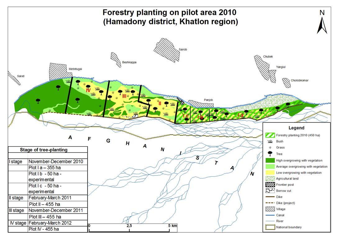
Technical specifications (related to technical drawing):
Shows the different parts of the reforestation zones in the target area for the rehabilitation of the Tugai floodplain ecosystem.
Location: MSA Hamadoni. Khatlon
Date: 21 May 2011
Technical knowledge required for field staff / advisors: high
Technical knowledge required for land users: low (Once they are trained, the actual activities are just basic planting and care of the vegetation.)
Main technical functions: improvement of ground cover, stabilisation of soil (eg by tree roots against land slides), increase of groundwater level / recharge of groundwater
Secondary technical functions: increase / maintain water stored in soil, sediment retention / trapping, sediment harvesting, reduction in wind speed, promotion of vegetation species and varieties (quality, eg palatable fodder), improved wild animal habitats
Scattered / dispersed
Vegetative material: T : trees / shrubs
Number of plants per (ha): 80
Vertical interval between rows / strips / blocks (m): 12
Spacing between rows / strips / blocks (m): 10
Trees/ shrubs species: reed stands, poplars, djigda, tamarisk thickets
Author:
CAREC, ACTED/CAREC
4.2 General information regarding the calculation of inputs and costs
other/ national currency (specify):
Tajik Somoni
If relevant, indicate exchange rate from USD to local currency (e.g. 1 USD = 79.9 Brazilian Real): 1 USD =:
4.5
Indicate average wage cost of hired labour per day:
5.50
4.3 Establishment activities
| Activity | Timing (season) | |
|---|---|---|
| 1. | Planting of tree seedlings | autumn |
4.4 Costs and inputs needed for establishment
| Specify input | Unit | Quantity | Costs per Unit | Total costs per input | % of costs borne by land users | |
|---|---|---|---|---|---|---|
| Labour | Planting of tree seedlings | person day | 5.0 | 5.44 | 27.2 | |
| Equipment | Machine use | machine hours | 5.0 | 20.0 | 100.0 | |
| Equipment | Tools | pieces | 5.0 | 4.44 | 22.2 | 100.0 |
| Plant material | Seedlings | Pieces | 80.0 | 1.10625 | 88.5 | |
| Fertilizers and biocides | Compost/manure | kg | 80.0 | 0.22125 | 17.7 | 100.0 |
| Total costs for establishment of the Technology | 255.6 | |||||
| Total costs for establishment of the Technology in USD | 56.8 | |||||
Comments:
Duration of establishment phase: 1 month(s)
4.5 Maintenance/ recurrent activities
| Activity | Timing/ frequency | |
|---|---|---|
| 1. | Maintenance of vegetation cover | annually |
4.6 Costs and inputs needed for maintenance/ recurrent activities (per year)
| Specify input | Unit | Quantity | Costs per Unit | Total costs per input | % of costs borne by land users | |
|---|---|---|---|---|---|---|
| Labour | Maintenance of vegetation cover | person days | 18.0 | 5.5555 | 100.0 | 50.0 |
| Equipment | Tools | Pieces | 2.0 | 5.0 | 10.0 | |
| Total costs for maintenance of the Technology | 110.0 | |||||
| Total costs for maintenance of the Technology in USD | 24.44 | |||||
Comments:
Machinery/ tools: shovel, knife
The costs are based on an area of 1 h.a. using 2010 prices, split from the entire scheme.
4.7 Most important factors affecting the costs
Describe the most determinate factors affecting the costs:
The intial costs of the activities are met by the donor project budget, the labourers are paid directly for their efforts under a `food for work' scheme. The seedlings, transport and tools are provided for planting, and the inhabitants are reimbursed in the longer term by the establishment of tree nurseries and fruit tree orchards.
5. Natural and human environment
5.1 Climate
Annual rainfall
- < 250 mm
- 251-500 mm
- 501-750 mm
- 751-1,000 mm
- 1,001-1,500 mm
- 1,501-2,000 mm
- 2,001-3,000 mm
- 3,001-4,000 mm
- > 4,000 mm
Agro-climatic zone
- semi-arid
Thermal climate class: temperate
5.2 Topography
Slopes on average:
- flat (0-2%)
- gentle (3-5%)
- moderate (6-10%)
- rolling (11-15%)
- hilly (16-30%)
- steep (31-60%)
- very steep (>60%)
Landforms:
- plateau/plains
- ridges
- mountain slopes
- hill slopes
- footslopes
- valley floors
Altitudinal zone:
- 0-100 m a.s.l.
- 101-500 m a.s.l.
- 501-1,000 m a.s.l.
- 1,001-1,500 m a.s.l.
- 1,501-2,000 m a.s.l.
- 2,001-2,500 m a.s.l.
- 2,501-3,000 m a.s.l.
- 3,001-4,000 m a.s.l.
- > 4,000 m a.s.l.
5.3 Soils
Soil depth on average:
- very shallow (0-20 cm)
- shallow (21-50 cm)
- moderately deep (51-80 cm)
- deep (81-120 cm)
- very deep (> 120 cm)
Soil texture (topsoil):
- coarse/ light (sandy)
Topsoil organic matter:
- medium (1-3%)
If available, attach full soil description or specify the available information, e.g. soil type, soil PH/ acidity, Cation Exchange Capacity, nitrogen, salinity etc.
Soil fertility: Medium
Soil drainage/infiltration: Medium
Soil water storage capacity: Medium
5.4 Water availability and quality
Ground water table:
< 5 m
Availability of surface water:
excess
Water quality (untreated):
for agricultural use only (irrigation)
Comments and further specifications on water quality and quantity:
Availability of surface water: Also medium
5.5 Biodiversity
Species diversity:
- medium
5.6 Characteristics of land users applying the Technology
Market orientation of production system:
- subsistence (self-supply)
Off-farm income:
- > 50% of all income
Relative level of wealth:
- very poor
- poor
Individuals or groups:
- groups/ community
Gender:
- women
- men
Indicate other relevant characteristics of the land users:
Land users applying the Technology are mainly common / average land users
Population density: 10-50 persons/km2
Annual population growth: 1% - 2%
80% of the land users are poor.
20% of the land users are poor.
Off-farm income specification: There is significant income from remittances sent back from Russia.
5.7 Average area of land used by land users applying the Technology
- < 0.5 ha
- 0.5-1 ha
- 1-2 ha
- 2-5 ha
- 5-15 ha
- 15-50 ha
- 50-100 ha
- 100-500 ha
- 500-1,000 ha
- 1,000-10,000 ha
- > 10,000 ha
Is this considered small-, medium- or large-scale (referring to local context)?
- small-scale
Comments:
Average of 3.5 ha per household
5.8 Land ownership, land use rights, and water use rights
Land ownership:
- state
Land use rights:
- communal (organized)
Comments:
Different parts of the Tugai system are allocated to individual households through the local Jamoat, as there are no formal land user certificates.
5.9 Access to services and infrastructure
health:
- poor
- moderate
- good
education:
- poor
- moderate
- good
technical assistance:
- poor
- moderate
- good
employment (e.g. off-farm):
- poor
- moderate
- good
markets:
- poor
- moderate
- good
energy:
- poor
- moderate
- good
roads and transport:
- poor
- moderate
- good
drinking water and sanitation:
- poor
- moderate
- good
financial services:
- poor
- moderate
- good
6. Impacts and concluding statements
6.1 On-site impacts the Technology has shown
Socio-cultural impacts
SLM/ land degradation knowledge
Improved livelihoods and human well-being
Comments/ specify:
Helps to protect the land on which the inhabitants make their living and provides them with environmental education on land use systems.
Ecological impacts
Soil
soil cover
soil loss
Biodiversity: vegetation, animals
plant diversity
animal diversity
beneficial species
habitat diversity
Climate and disaster risk reduction
flood impacts
Other ecological impacts
River bank protection
6.2 Off-site impacts the Technology has shown
buffering/ filtering capacity
Comments/ specify:
Increased protection to cultivated lands and settlements.
damage on neighbours' fields
damage on public/ private infrastructure
6.3 Exposure and sensitivity of the Technology to gradual climate change and climate-related extremes/ disasters (as perceived by land users)
Gradual climate change
Gradual climate change
| Season | increase or decrease | How does the Technology cope with it? | |
|---|---|---|---|
| annual temperature | increase | not known |
Climate-related extremes (disasters)
Meteorological disasters
| How does the Technology cope with it? | |
|---|---|
| local rainstorm | not known |
| local windstorm | not known |
Climatological disasters
| How does the Technology cope with it? | |
|---|---|
| drought | not well |
Hydrological disasters
| How does the Technology cope with it? | |
|---|---|
| general (river) flood | well |
Other climate-related consequences
Other climate-related consequences
| How does the Technology cope with it? | |
|---|---|
| reduced growing period | not known |
Comments:
The choice of species are those that are able to grow in very wet/flood conditions.
6.4 Cost-benefit analysis
How do the benefits compare with the establishment costs (from land users’ perspective)?
Short-term returns:
neutral/ balanced
Long-term returns:
positive
How do the benefits compare with the maintenance/ recurrent costs (from land users' perspective)?
Short-term returns:
slightly negative
Long-term returns:
positive
Comments:
The inhabitants will not see any returns in the short term, and will have to maintain the forest for several years before they will reap the benefits in the longer term.
6.5 Adoption of the Technology
If available, quantify (no. of households and/ or area covered):
520 families and 100% of the area covered
Of all those who have adopted the Technology, how many did so spontaneously, i.e. without receiving any material incentives/ payments?
- 0-10%
Comments:
100% of land user families have adopted the Technology with external material support
520 land user families have adopted the Technology with external material support
Comments on acceptance with external material support: The entire area selected for the project was reforested.
There is no trend towards spontaneous adoption of the Technology
6.7 Strengths/ advantages/ opportunities of the Technology
| Strengths/ advantages/ opportunities in the land user’s view |
|---|
| Land users are happy that their land is protected and that they are being provided with added incentives through food for work and the construction of orchards and nurseries. |
| Strengths/ advantages/ opportunities in the compiler’s or other key resource person’s view |
|---|
| The Tugai ecosystem acts as natural mitigation system for large scale flooding in the target area. It does not rely on heavy structural maintenance such as artificial dikes or gabions. |
| Involves representatives of target communities in the mitigation works. It gives them a sense of ownership towards the activities. |
6.8 Weaknesses/ disadvantages/ risks of the Technology and ways of overcoming them
| Weaknesses/ disadvantages/ risks in the compiler’s or other key resource person’s view | How can they be overcome? |
|---|---|
| Mitigation is not an instant and obvious return, so the benefits are less obvious. | Land users need to be educated about the environmental and risk mitigation benefits of the project. Practical demonstrations are advisable. Furthermore, as there is no instant benefit it is also advisable to offer land users incentives (e.g. food for work and construction of household orchards and nurseries). |
| Maintenance of the reforested area requires labour post-reforestation phase (e.g. watering). | The use of incentives is advisable to increase motivation to participate. |
7. References and links
7.1 Methods/ sources of information
- field visits, field surveys
- interviews with land users
When were the data compiled (in the field)?
04/05/2011
Links and modules
Expand all Collapse allLinks
No links
Modules
No modules