Village irrigation schemes developed using the PMN/IPRODI approach [Mali]
- Creation:
- Update:
- Compiler: Dieter Nill
- Editor: –
- Reviewers: Deborah Niggli, Alexandra Gavilano
Périmètres irrigués villageois type PMN/IPRODI (French)
technologies_1630 - Mali
View sections
Expand all Collapse all1. General information
1.2 Contact details of resource persons and institutions involved in the assessment and documentation of the Technology
SLM specialist:
Ali Yehia Ag Mohamed
PMN/IPRODI
Mali
SLM specialist:
Kliewe Matthias
PMN/IPRODI
Mali
Name of project which facilitated the documentation/ evaluation of the Technology (if relevant)
Manual of Good Practices in Small Scale Irrigation in the Sahel (GIZ )Name of the institution(s) which facilitated the documentation/ evaluation of the Technology (if relevant)
Deutsche Gesellschaft für Internationale Zusammenarbeit (GIZ) - Germany1.3 Conditions regarding the use of data documented through WOCAT
The compiler and key resource person(s) accept the conditions regarding the use of data documented through WOCAT:
Yes
1.4 Declaration on sustainability of the described Technology
Is the Technology described here problematic with regard to land degradation, so that it cannot be declared a sustainable land management technology?
No
1.5 Reference to Questionnaire(s) on SLM Approaches (documented using WOCAT)

Participatory approach to small-scale irrigation [Mali]
The participatory approach to small-scale irrigation ensures skills and expertise are transferred to scheme beneficiaries and other stakeholders.
- Compiler: Dieter Nill
2. Description of the SLM Technology
2.1 Short description of the Technology
Definition of the Technology:
Village irrigation schemes (VISs) help to control the water supply and significantly increase yields.
2.2 Detailed description of the Technology
Description:
Village irrigation schemes (VISs) are a concept and a development typology created in the 1970s and 80s. Using a relatively simple development concept, it was possible to create production units that were built and managed by local people in areas seriously affected by drought and a sharp decline in inundation events in the 1970s and 80s. Instead of being dependent on food aid, local people operating a VIS were able to guarantee sufficient rice production to cover their village’s food needs. With one pumping facility and one canal network installed, it is possible to control the water supply for an area of at least 20 hectares, thus creating the required conditions for intensive rice growing.
Prior to the installation of the scheme, the sites are not suitable for rice growing. Yields significantly increase as a result of the work carried out. An average harvest of six tonnes per hectare increases incomes. With an average price of 125 CFA francs per kilo of paddy, the rate of sales reaches 750,000 CFA francs per hectare. The surplus per hectare is estimated at 300,000 CFA francs.
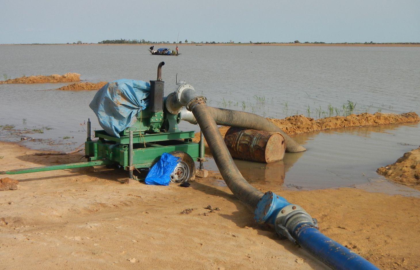
A VIS comprises a pumping station, small-scale facilities infrastructure, and irrigation and drainage networks. The pumping station consists of a pump unit fitted with a diesel motor with two or three 28 to 38 horse-power cylinders and a centrifugal pump with a capacity of 350 to 480 cubic metres per hour. The pump is positioned right alongside the water source (river, lake) and is mounted on a mobile chassis so it can be repositioned as and when required
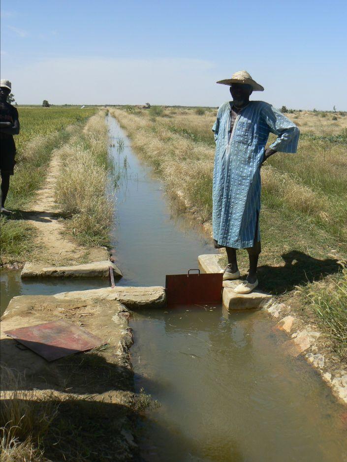
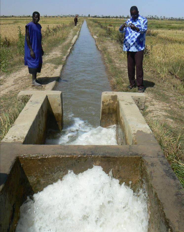
and depending on the situation of the water source, which can vary considerably during the winter growing season. At the end of the growing season, the pump unit can be stored in a secure, weather-proof location (out of the sun, rain, etc.). Water is then pumped through a flexible hose of reinforced polyethylene (the lengths generally being multiples of 50 metres, but no longer than 150 metres) up into the delivery basin where the energy carried in the turbulent pumped water is dissipated to prevent erosion damage and where the flow is calmed from turbulent to laminar. From the delivery basin onwards, the system makes use of gravity to feed its open canal network. The majority of the network is comprised of earthen structures, with only a section of the main canal being lined (usually a length of between 150 to 300 metres leading from the delivery basin outflow). The secondary and/or tertiary canals are supplied with water through a division box that apportions supply using a system of (‘all or nothing’) gates. Plots are watered from the tertiary canal by turning on the PVC hose.
Initially, villagers are able to express their need for a VIS through a village diagnostic exercise. This installation request is then taken up by the communes’ PDESC. A formal request is then referred to the mayor and drawn up by the community. The support structure (PMN/IPRODI) reviews the request and carries out a preliminary feasibility study. Decisions are then taken in a planning workshop on which schemes to prioritise. Following this, private planning consultants are commissioned to conduct feasibility studies. In parallel, technical and financial analyses are carried out by the programme’s planners, who also validate the studies. A meeting is held to inform and raise the awareness of the beneficiary communities about the development approach. The community is then requested to contribute their labour as part of the HLIW measures. The financial contribution required for the pump unit is up to 30% of its cost.
Farming a VIS (intensive rice growing) is fundamentally different to other, more traditional production systems to which farmers are accustomed (extensive rice growing in floodplains and millet growing in non-flooded areas). VISs require the purchase of inputs and the sale of at least part of the produce. Farming a VIS requires the development and good functioning of a value chain with many more links upstream and downstream of production and beyond the confines of the village than would be found in a traditional system. Although the VIS was initially conceived as a drought response mechanism in the 1970 and 80s, VIS farming encourages farmers to become more integrated in the rural and regional economy.
2.3 Photos of the Technology
Media Gallery
2.5 Country/ region/ locations where the Technology has been applied and which are covered by this assessment
Country:
Mali
Region/ State/ Province:
Mali
Further specification of location:
Mopti, Timbuktu
Comments:
Total area covered by the SLM Technology is 0.4 km2.
Five communes in the Mopti region and 38 communes in the Timbuktu region.
Installation of 489 VISs in at least 43 communes. Farmable land: 16,832 hectares. Approximate number of beneficiaries: 335,200 People.
The area of schemes developed by PMN/IPRODI ranges from 30 to 40 hectares. Initially, the programme installed 30-hectare schemes supplied with two-cylinder pump units. Since 2004, it has only developed 40-hectare schemes supplied with three-cylinder pump units. All the schemes are divided up into 0.25-hectare plots, making a total of 160 plots. The maximum distance from the sprinkler to the drain on the other side is 100 metres.
2.6 Date of implementation
If precise year is not known, indicate approximate date:
- 10-50 years ago
2.7 Introduction of the Technology
Specify how the Technology was introduced:
- through projects/ external interventions
Comments (type of project, etc.):
Since 1997, by PMN/IPRODI
3. Classification of the SLM Technology
3.1 Main purpose(s) of the Technology
- improve production
- conserve ecosystem
3.2 Current land use type(s) where the Technology is applied
Land use mixed within the same land unit:
Yes
Specify mixed land use (crops/ grazing/ trees):
- Agro-pastoralism (incl. integrated crop-livestock)

Cropland
- Annual cropping
- rice
Number of growing seasons per year:
- 1
Specify:
Longest growing period in days: 120, Longest growing period from month to month: August-November

Grazing land
Comments:
Major land use problems (compiler’s opinion): Prior to the installation of the scheme, the sites are not suitable for rice growing.
Livestock density: 1-10 LU /km2
3.4 Water supply
Water supply for the land on which the Technology is applied:
- mixed rainfed-irrigated
3.5 SLM group to which the Technology belongs
- irrigation management (incl. water supply, drainage)
- water diversion and drainage
- surface water management (spring, river, lakes, sea)
3.6 SLM measures comprising the Technology

management measures
- M7: Others
Comments:
Specification of other management measures: irrigation schemes
3.7 Main types of land degradation addressed by the Technology

water degradation
- Ha: aridification
Comments:
Main causes of degradation: over abstraction / excessive withdrawal of water (for irrigation, industry, etc.)
3.8 Prevention, reduction, or restoration of land degradation
Specify the goal of the Technology with regard to land degradation:
- restore/ rehabilitate severely degraded land
4. Technical specifications, implementation activities, inputs, and costs
4.1 Technical drawing of the Technology
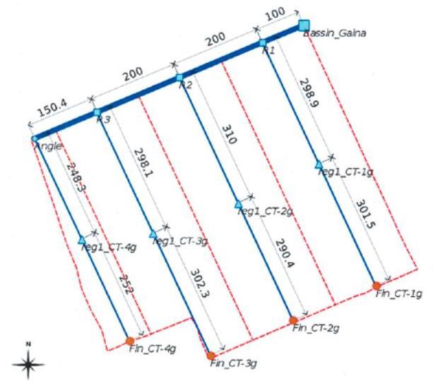
Technical specifications (related to technical drawing):
Layout plan of the irrigation network (in blue) and the drainage network (in red)
Technical knowledge required for field staff / advisors: high
Technical knowledge required for land users: moderate
Main technical functions: increase / maintain water stored in soil, water harvesting / increase water supply, promotion of vegetation species and varieties (quality, eg palatable fodder)
Author:
PMN/IPRODI
4.2 General information regarding the calculation of inputs and costs
other/ national currency (specify):
CFA Franc
If relevant, indicate exchange rate from USD to local currency (e.g. 1 USD = 79.9 Brazilian Real): 1 USD =:
517.0
4.3 Establishment activities
| Activity | Timing (season) | |
|---|---|---|
| 1. | formal request for irrigation scheme | |
| 2. | support structure (PMN/IPRODI) reviews the request and carries out a preliminary feasibility study | |
| 3. | Decisions are then taken in a planning workshop on which schemes to prioritise | |
| 4. | private planning consultants are commissioned to conduct feasibility studies | |
| 5. | In parallel, technical and financial analyses are carried out by the programme’s planners | |
| 6. | meeting is held to inform and raise the awareness of the beneficiary communities about the development approach | |
| 7. | community is then requested to contribute their labour |
4.4 Costs and inputs needed for establishment
| Specify input | Unit | Quantity | Costs per Unit | Total costs per input | % of costs borne by land users | |
|---|---|---|---|---|---|---|
| Other | total construction | ha | 1.0 | 2497.0 | 2497.0 | 100.0 |
| Total costs for establishment of the Technology | 2497.0 | |||||
| Total costs for establishment of the Technology in USD | 4.83 | |||||
4.5 Maintenance/ recurrent activities
| Activity | Timing/ frequency | |
|---|---|---|
| 1. | Regularly maintaining the facilities and networks | |
| 2. | Agricultural advisory support and monitoring of crops by the technical services |
4.7 Most important factors affecting the costs
Describe the most determinate factors affecting the costs:
The development costs are estimated at 1.3 million CFA francs per hectare (2,497 Dollar).
On the technical side, numerous scheme configurations have been observed. The most common involves a limited number of small-scale distribution control structures and a network of open, earthen canals. This type of scheme requires an investment in the order of between 1 and 1.5 million CFA francs per hectare. It also fosters the large-scale participation of villagers in all the building works, particularly excavation work and the installation of plots. At the other end of the spectrum are the VISs that have lined canals throughout their entire irrigation network. These require much more substantial investment (up to 7 or 8 million CFA francs per hectare) and building works (including plot installation) are generally carried out by contractors. As yet, no study has indicated that the yields and technical lifespan of such high-cost ‘sophisticated’ schemes are greater than those of ‘basic’ schemes.
5. Natural and human environment
5.1 Climate
Annual rainfall
- < 250 mm
- 251-500 mm
- 501-750 mm
- 751-1,000 mm
- 1,001-1,500 mm
- 1,501-2,000 mm
- 2,001-3,000 mm
- 3,001-4,000 mm
- > 4,000 mm
Agro-climatic zone
- semi-arid
Thermal climate class: tropics
5.2 Topography
Slopes on average:
- flat (0-2%)
- gentle (3-5%)
- moderate (6-10%)
- rolling (11-15%)
- hilly (16-30%)
- steep (31-60%)
- very steep (>60%)
Landforms:
- plateau/plains
- ridges
- mountain slopes
- hill slopes
- footslopes
- valley floors
Altitudinal zone:
- 0-100 m a.s.l.
- 101-500 m a.s.l.
- 501-1,000 m a.s.l.
- 1,001-1,500 m a.s.l.
- 1,501-2,000 m a.s.l.
- 2,001-2,500 m a.s.l.
- 2,501-3,000 m a.s.l.
- 3,001-4,000 m a.s.l.
- > 4,000 m a.s.l.
5.3 Soils
Soil depth on average:
- very shallow (0-20 cm)
- shallow (21-50 cm)
- moderately deep (51-80 cm)
- deep (81-120 cm)
- very deep (> 120 cm)
Soil texture (topsoil):
- medium (loamy, silty)
- fine/ heavy (clay)
Topsoil organic matter:
- medium (1-3%)
- low (<1%)
5.4 Water availability and quality
Ground water table:
5-50 m
Availability of surface water:
medium
Water quality (untreated):
for agricultural use only (irrigation)
5.5 Biodiversity
Species diversity:
- medium
5.6 Characteristics of land users applying the Technology
Market orientation of production system:
- mixed (subsistence/ commercial)
Off-farm income:
- 10-50% of all income
Relative level of wealth:
- poor
- average
Level of mechanization:
- manual work
Gender:
- men
Indicate other relevant characteristics of the land users:
Population density: < 10 persons/km2
Annual population growth: 2% - 3%
10% of the land users are rich.
50% of the land users are average wealthy.
30% of the land users are poor.
10% of the land users are very poor.
5.7 Average area of land used by land users applying the Technology
- < 0.5 ha
- 0.5-1 ha
- 1-2 ha
- 2-5 ha
- 5-15 ha
- 15-50 ha
- 50-100 ha
- 100-500 ha
- 500-1,000 ha
- 1,000-10,000 ha
- > 10,000 ha
Is this considered small-, medium- or large-scale (referring to local context)?
- small-scale
5.8 Land ownership, land use rights, and water use rights
Comments:
The irrigated land is allocated by the chief
5.9 Access to services and infrastructure
health:
- poor
- moderate
- good
education:
- poor
- moderate
- good
technical assistance:
- poor
- moderate
- good
employment (e.g. off-farm):
- poor
- moderate
- good
markets:
- poor
- moderate
- good
energy:
- poor
- moderate
- good
roads and transport:
- poor
- moderate
- good
drinking water and sanitation:
- poor
- moderate
- good
financial services:
- poor
- moderate
- good
6. Impacts and concluding statements
6.1 On-site impacts the Technology has shown
Socio-economic impacts
Production
crop production
risk of production failure
product diversity
production area
Income and costs
farm income
diversity of income sources
Socio-cultural impacts
food security/ self-sufficiency
community institutions
contribution to human well-being
Comments/ specify:
Instead of being dependent on food aid, local people operating a VIS are able to guarantee sufficient rice production to cover their village’s food needs.
Ecological impacts
Water cycle/ runoff
water quantity
harvesting/ collection of water
groundwater table/ aquifer
Soil
soil moisture
6.3 Exposure and sensitivity of the Technology to gradual climate change and climate-related extremes/ disasters (as perceived by land users)
Gradual climate change
Gradual climate change
| Season | increase or decrease | How does the Technology cope with it? | |
|---|---|---|---|
| annual temperature | increase | well |
Climate-related extremes (disasters)
Meteorological disasters
| How does the Technology cope with it? | |
|---|---|
| local rainstorm | well |
| local windstorm | well |
Climatological disasters
| How does the Technology cope with it? | |
|---|---|
| drought | well |
Hydrological disasters
| How does the Technology cope with it? | |
|---|---|
| general (river) flood | well |
Other climate-related consequences
Other climate-related consequences
| How does the Technology cope with it? | |
|---|---|
| reduced growing period | well |
6.4 Cost-benefit analysis
How do the benefits compare with the establishment costs (from land users’ perspective)?
Short-term returns:
very positive
Long-term returns:
very positive
How do the benefits compare with the maintenance/ recurrent costs (from land users' perspective)?
Short-term returns:
very positive
Long-term returns:
very positive
6.5 Adoption of the Technology
Comments:
The community is requested to contribute their labour as part of the HLIW measures. The financial contribution required for the pump unit is up to 30% of its cost
There is a moderate trend towards spontaneous adoption of the Technology
On the back of over 15 years’ work and major investments, the programme has been able to develop 489 VISs across an intervention area that covers six circles (second-tier government structures). While most of the VISs grow in-season rice (July to December), 10% grow rice off season and 20%, located mainly in the Diré area, grow wheat (October to March). A small percentage of VISs (around 2%) grow two crops a year. The reasons for this low percentage are the risks involved and clashes in the growing calendar. Many of the pump units are, however, used several times over (on different sites for different crops).
6.7 Strengths/ advantages/ opportunities of the Technology
| Strengths/ advantages/ opportunities in the land user’s view |
|---|
| Option for scheme extensions to be undertaken by the beneficiaries themselves |
| Strengths/ advantages/ opportunities in the compiler’s or other key resource person’s view |
|---|
| Yields significantly increase |
| Building more sustainable and less costly schemes through the careful configuration of irrigation canals |
| Low investment costs |
| Existence of 15-year-old schemes that are still productive and in good condition |
| Possibility for beneficiaries to replace spent pump units using their own savings |
6.8 Weaknesses/ disadvantages/ risks of the Technology and ways of overcoming them
| Weaknesses/ disadvantages/ risks in the compiler’s or other key resource person’s view | How can they be overcome? |
|---|---|
| scheme areas may become a source of conflict |
7. References and links
7.1 Methods/ sources of information
- field visits, field surveys
- interviews with land users
When were the data compiled (in the field)?
01/07/2012
7.2 References to available publications
Title, author, year, ISBN:
Manual of Good Practices in Small Scale Irrigation in the Sahel. Experiences from Mali. Published by GIZ in 2014.
Available from where? Costs?
http://star-www.giz.de/starweb/giz/pub/servlet.starweb
Title, author, year, ISBN:
IPRODI (2009): Approche du PMN pour le développement de l’irrigation de proximité, region de Tombouctou [North Mali Programme’s approach to developing small-scale irrigation in the Timbuktu region].
Links and modules
Expand all Collapse allLinks
Participatory approach to small-scale irrigation [Mali]
The participatory approach to small-scale irrigation ensures skills and expertise are transferred to scheme beneficiaries and other stakeholders.
- Compiler: Dieter Nill
Modules
No modules