
Gully plug [Jordan]
- Creation:
- Update:
- Compiler: Mira Haddad
- Editor: –
- Reviewers: William Critchley, Rima Mekdaschi Studer
السدات
technologies_5862 - Jordan
View sections
Expand all Collapse all1. General information
1.2 Contact details of resource persons and institutions involved in the assessment and documentation of the Technology
SLM specialist:
Strohmeier Stefan
International Center of Agriculture Research in the Dry Areas (ICARDA)
Jordan
SLM specialist:
SLM specialist:
Evett Steve
USDA Agricultural Research Service
United States
Name of the institution(s) which facilitated the documentation/ evaluation of the Technology (if relevant)
International Center for Agricultural Research in the Dry Areas (ICARDA) - Lebanon1.3 Conditions regarding the use of data documented through WOCAT
The compiler and key resource person(s) accept the conditions regarding the use of data documented through WOCAT:
Yes
1.4 Declaration on sustainability of the described Technology
Is the Technology described here problematic with regard to land degradation, so that it cannot be declared a sustainable land management technology?
No
2. Description of the SLM Technology
2.1 Short description of the Technology
Definition of the Technology:
Gully plugs aim at rehabilitating active gullies in dryland watersheds, which are prone to erosion through concentrated surface runoff. Multiple gullies plugged in succession dissipate runoff energy, foster local water retention and infiltration, encourage sedimentation, assist in the stabilization of gully bed and side banks, and stimulate revegetation of flow paths; the channel measures must be combined with proper SLM in the catchments upstream.
2.2 Detailed description of the Technology
Description:
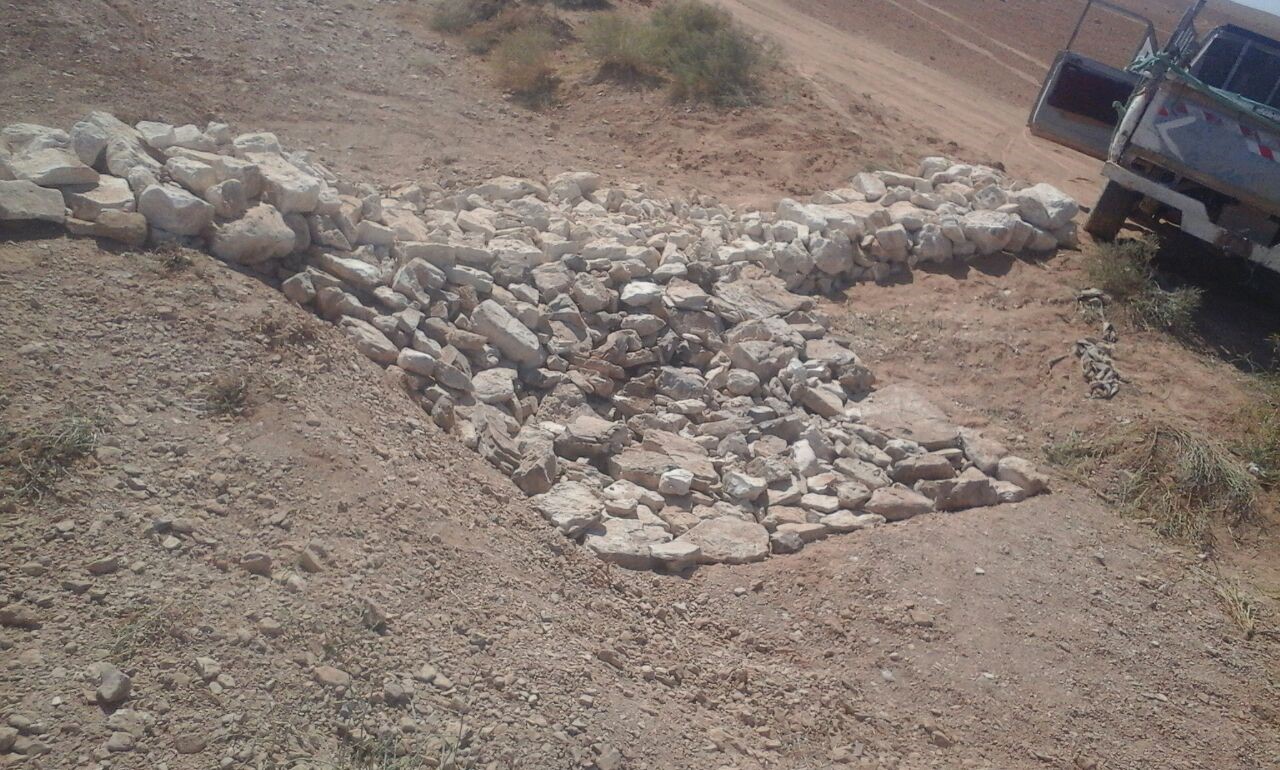
Characteristics: Multiple gully plugs positioned sequentially within a gully system interrupt concentrated surface runoff and reduce its erosive power. The plugs are each made of multiple cobbles/stones mostly ranging between 10 and 30 cm diameter and constructed to ensure a stable structure. The plugs started at the head of the gully (upstream) and ranges from 1.5 - 3.7 m in width with an average of 2.5 m. For heavily eroded and very unstable sections, gabions can be used also. The structures are around 1.0 to 1.5-m high, anchored into the sidewalls, and around 0.20 to 0.35 m deep into the gully bed, built up to around 1/3 to max. 1/2 of the gully depth - ensuring the concentrated flow stays within the channel and does not overflow the side banks. The top of the plug is U-shaped, with the sides built higher than the centre. Upslope, the plugs are packed with soil to trap sediments (stopping it flowing through the structure), and downslope the plugs have an apron to dissipate the energy of overflowing water, into a micro stilling basin. The downslope side of the gully plug is sloped rather than vertical. The large stones add roughness to the slope, creating a rough spillway that dissipates erosive energy. In the direction of gully flow, several gully plugs are placed such that the upper gully apron is set at approximately the height of the following downstream gully crest.
Environment: The technology is used in a watershed close to Al Majeddyeh village, located in the Middle Badia zone, approximately 30 km south-east of Amman. The climate is arid and warm (Palmer, 2013). The average annual rainfall is around 130 mm. The natural environment is labelled as steppe, “BSh” in the köppen classification. The human environment is characterized by agropastoralists. They are semi-nomadic and live in villages around the watershed, for example, Al Majeddyeh village.
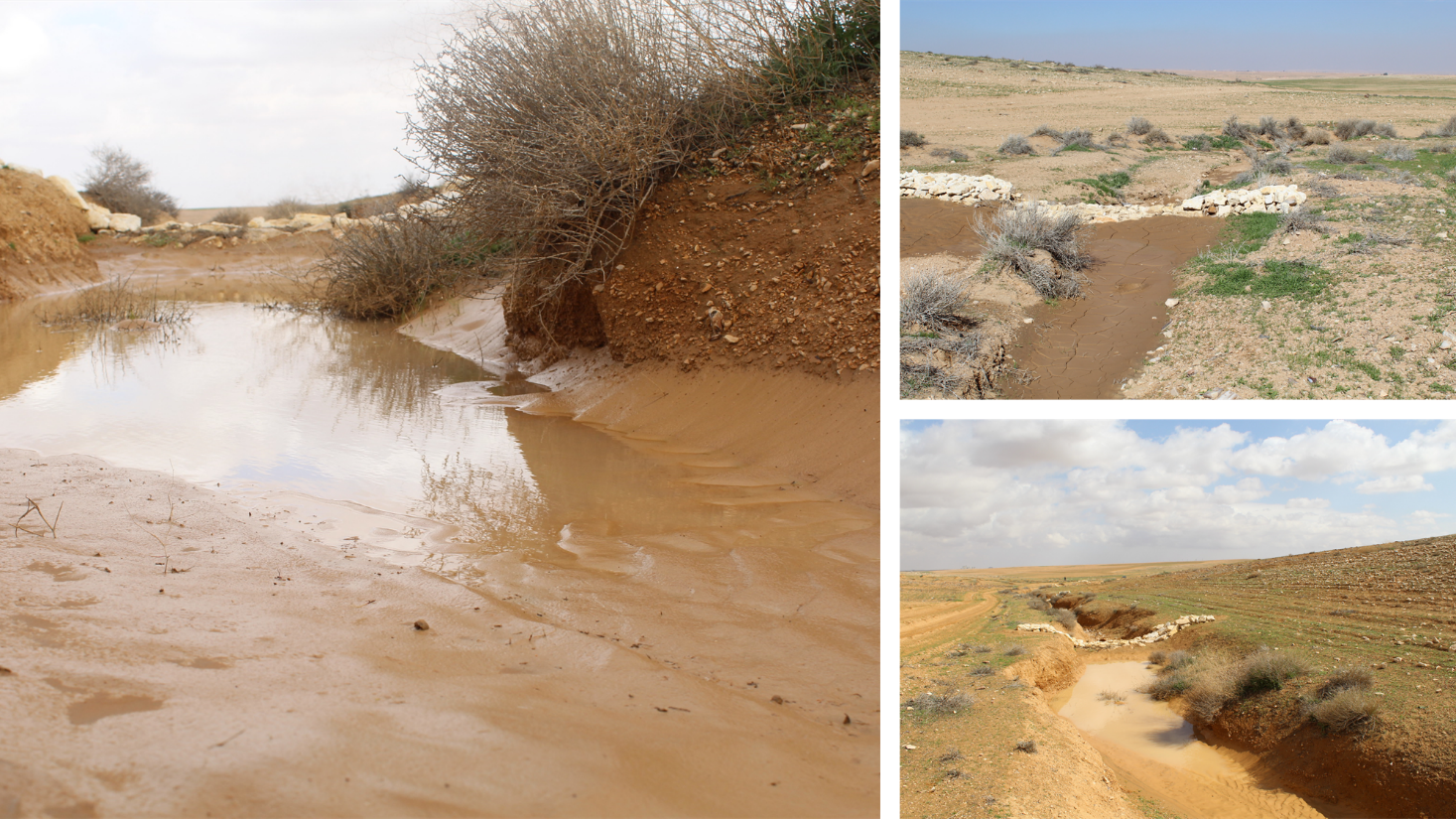
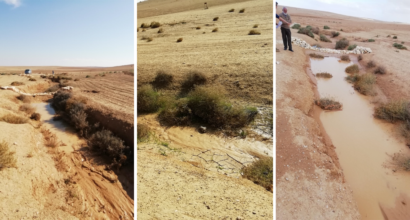
Purpose: The measure interrupts the concentrated flow, reduces velocity, and dissipates energy. Multiple structures along the gully decrease the erosive power of runoff, retaining a fraction of the runoff, inducing sedimentation (upstream of the plug), thus protecting the gully bed from further deep-scouring, and strengthening the gully side banks, especially when this is linked with re-vegetation. Over time, the establishing vegetation (roots and surface cover) stabilizes the soil and protects it from concentrated flow erosion. To be effective, gully plug emplacement requires SLM in upland areas. These measures then jointly mitigate peak runoff generation and accordingly reduce downstream flooding.
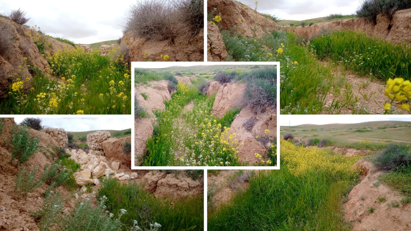
Major activities: Upland SLM is essential. In the specific watershed rehabilitation context, upland SLM was achieved through micro water harvesting and re-vegetation through native shrubs (the “VALLERANI” method). Gully morphology assessment is required for gully plug design, and positioning and earthwork excavation is necessary for foundation preparation in the gully bed and wall anchors. Proper layering of various size stones and shaping of gully plugs is necessary as is the addition of a packed soil pack upstream of the stone structure, to semi-seal the surface and to pond water. Then gully walls are revegetated through native seedlings: these benefit from the water ponding upstream prior to sedimentation upstream of the gully and enhanced soil water storage in the sediments once the gully is filled.
Benefits: Stops ongoing land degradation and gully deepening, and achieves a certain degree of rehabilitation; retains a fraction of runoff water and sediments in the watershed – water mainly infiltrates and provides moisture to the gully vegetation; gully vegetation serves various purposes including livestock fodder, reduction of flow velocities in the gully, and retention of further sediment.
Land user's opinion: Land users benefit from the vegetation (e.g. fruit trees can potentially be out-planted), as well as ponded water for livestock; however, the technology is labor-intensive, and therefore costly, and landowners (at the local target site) require incentives to carry out the work.
2.3 Photos of the Technology
Media Gallery
2.5 Country/ region/ locations where the Technology has been applied and which are covered by this assessment
Country:
Jordan
Region/ State/ Province:
Amman governorate/Al Jizza/Al Majeddyeh village
Specify the spread of the Technology:
- applied at specific points/ concentrated on a small area
Is/are the technology site(s) located in a permanently protected area?
No
Map
×2.6 Date of implementation
Indicate year of implementation:
2017
2.7 Introduction of the Technology
Specify how the Technology was introduced:
- during experiments/ research
- through projects/ external interventions
3. Classification of the SLM Technology
3.1 Main purpose(s) of the Technology
- reduce, prevent, restore land degradation
- preserve/ improve biodiversity
- reduce risk of disasters
3.2 Current land use type(s) where the Technology is applied
Land use mixed within the same land unit:
Yes
Specify mixed land use (crops/ grazing/ trees):
- Agro-pastoralism (incl. integrated crop-livestock)

Grazing land
Extensive grazing:
- Semi-nomadic pastoralism

Waterways, waterbodies, wetlands
- Drainage lines, waterways
Main products/ services:
To convey and drain: Wd
3.3 Has land use changed due to the implementation of the Technology?
Has land use changed due to the implementation of the Technology?
- Yes (Please fill out the questions below with regard to the land use before implementation of the Technology)
Land use mixed within the same land unit:
No
Grazing land
Extensive grazing:
- Nomadism
- Semi-nomadic pastoralism
Animal type:
- goats
- sheep
Is integrated crop-livestock management practiced?
No
Products and services:
- meat
3.4 Water supply
Water supply for the land on which the Technology is applied:
- rainfed
Comments:
The measure mitigates the effect of surface runoff in concentrated flow areas - as a consequence of heavy rainfall events
3.5 SLM group to which the Technology belongs
- improved ground/ vegetation cover
- minimal soil disturbance
- cross-slope measure
- water harvesting; surface water management (spring, river, lakes, sea, riparian zone, riverbanks, seashore, lakeshore, spring shed); ecosystem-based disaster risk reduction
3.6 SLM measures comprising the Technology

vegetative measures
- V2: Grasses and perennial herbaceous plants

structural measures
- S6: Walls, barriers, palisades, fences

other measures
Specify:
Specify tillage system: no tillage
Specify residue management: grazed and retained
3.7 Main types of land degradation addressed by the Technology

soil erosion by water
- Wg: gully erosion/ gullying
- Wo: offsite degradation effects

physical soil deterioration
- Pk: slaking and crusting
- Pu: loss of bio-productive function due to other activities

water degradation
- Hs: change in quantity of surface water
- Hw: reduction of the buffering capacity of wetland areas
3.8 Prevention, reduction, or restoration of land degradation
Specify the goal of the Technology with regard to land degradation:
- reduce land degradation
- restore/ rehabilitate severely degraded land
4. Technical specifications, implementation activities, inputs, and costs
4.1 Technical drawing of the Technology
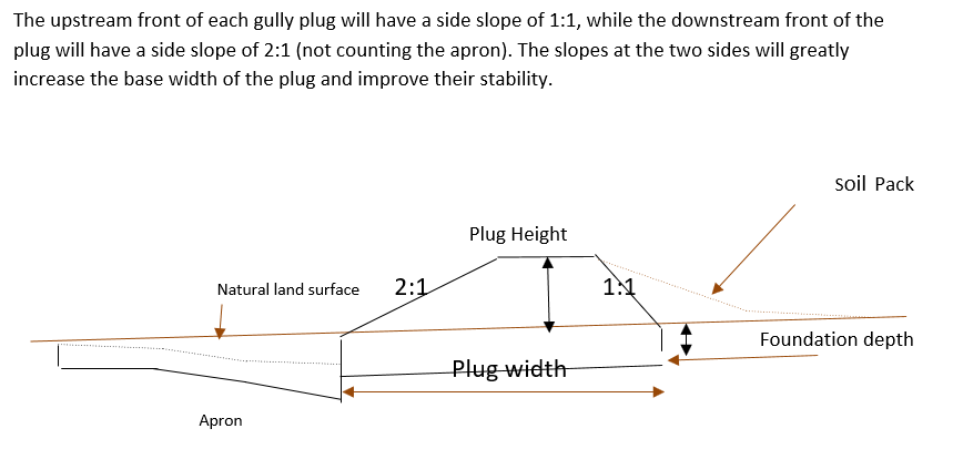
Technical specifications (related to technical drawing):
Emplacement in gully morphological system and watershed context: Determine the downstream starting point for the gully plugs and then extend upstream. The basic design is to keep the structure height maximum half the gully depth regardless of structure type. The spacing between structures is set as a gully depth function, structure crest height above the gully bed, and slope of the gully bed between structures. Additionally, the structure's final location will be shifted either upstream or downstream of the calculated gully bed level to place the structure in a more stable point if required. Following this methodology ensures variable spacing between structures to cope with both slope and depth of gully to ensure the sediment filling in between these structures occurs. In the case of distinct gully morphology and side banks that are very unstable, gabion structures can also be used/instead of a single stone pack.
Design of the Structure: Gully plugs must be anchored strong enough to resist water flow and prevent bypass from the side banks. A foundation is also required for all structures, depending on their dimensions and the bed's nature. At the specific site, the foundation depth for the planned structures ranges between 0.2 to 0.35 meters. The anchoring of gully plugs ranges between 1 and 1.5 meters. This depends on the existing condition of the banks at each structure location. Gully plugs have a downstream apron with a length of around 3 to 4 times the height of structures. The apron starts from below the bottom level of the foundation and gradually level halfway down. All gully plugs were designed to have a height maximum of 0.5 the depth of the gully. So each structure will pass water flow downward but keeping it inside the gully. Gabion structures have a sort of spillway from the top but at the same time protecting the banks. The configuration slightly differs from the normal stone structure, but the idea is to protect the sides and a spillway in the middle. The upstream front of each gully plug has a side slope of 1:1, while the downstream front of the plug has a side slope of 2:1 (not counting the apron). The slopes at the two sides greatly increase the base width of the plug and improve their stability. The gully plugs are provided with an amount of soil resulting from the foundation to form a triangle of soil fill against the structure at the upstream side; this improves the function of the gully plugin holding more water and trapping sediments. On the other side of each structure, the downstream side's slope is meant to tackle the overflow of water along the drop to safely return to the gully bed level without causing additional erosion. The rock-filled apron catches the flow and acts to dissipate erosive energy.
Author:
Steve Evett
Date:
15/08/2017
4.2 General information regarding the calculation of inputs and costs
Specify how costs and inputs were calculated:
- per Technology unit
Specify unit:
Gully plug
Specify currency used for cost calculations:
- USD
4.3 Establishment activities
| Activity | Timing (season) | |
|---|---|---|
| 1. | Implement upland watershed SLM (reference VALLERANI) | |
| 2. | Gully system/morphological assessment | |
| 3. | Determine plug design and implementation in the watershed | |
| 4. | Excavation earthworks for anchors and foundation | At least 2 months prior rainy season onset |
| 5. | Stone made construction of gully plugs (occasionally with gabions) | At least 1 month prior rainy season onset |
| 6. | Soil pack at upstream front | At least 1 month prior rainy season onset |
| 7. | Revegetation of gully side banks | At the onset of the rainy season |
Comments:
Gully plugs require proper SLM in the uplands. Revegetation of gully side banks is optional – depending on the recovery potential of the area.
4.4 Costs and inputs needed for establishment
| Specify input | Unit | Quantity | Costs per Unit | Total costs per input | % of costs borne by land users | |
|---|---|---|---|---|---|---|
| Labour | Field technician (design and oversight) | Labour Day (LD) per structure | 0.2 | 50.0 | 10.0 | |
| Labour | Workers (excavation/earthworks) | LD | 4.0 | 35.0 | 140.0 | |
| Labour | Workers (stone layering/construction) | LD | 4.0 | 35.0 | 140.0 | |
| Labour | Worker (out-planting of seedlings) | LD | 1.0 | 35.0 | 35.0 | |
| Equipment | Shovel, Pickaxe, buckets, ruler | Lump sum | 1.0 | 10.0 | 10.0 | |
| Plant material | Seedlings | per item | 10.0 | 0.5 | 5.0 | |
| Construction material | Stones | m3 | 4.0 | 10.0 | 40.0 | |
| Other | Logistics (seedling transport, local stone transport) | lump sum | 1.0 | 10.0 | 10.0 | |
| Total costs for establishment of the Technology | 390.0 | |||||
| Total costs for establishment of the Technology in USD | 390.0 | |||||
If land user bore less than 100% of costs, indicate who covered the remaining costs:
International research for the development project.
Comments:
Design is tailored for implementation through local workers (rural agro-pastoral community) and local materials. The engagement of local community workers as part of the specific project; if a professional contractor is hired costs can be significantly reduced.
4.5 Maintenance/ recurrent activities
| Activity | Timing/ frequency | |
|---|---|---|
| 1. | Inspect damage/status | After severe storms and runoff events |
| 2. | Maintain/repair/improve | After inspection |
Comments:
If optimally designed and connected with proper upland SLM the gully plug technology would not require maintenance; the measure induces nature-based (vegetation) protection of vulnerable gully zones over time.
4.6 Costs and inputs needed for maintenance/ recurrent activities (per year)
| Specify input | Unit | Quantity | Costs per Unit | Total costs per input | % of costs borne by land users | |
|---|---|---|---|---|---|---|
| Labour | Expert (investigation) | LD | 0.1 | 50.0 | 5.0 | |
| Labour | LD | 0.5 | 35.0 | 17.5 | ||
| Labour | LD | 1.0 | 35.0 | 35.0 | ||
| Construction material | stones | m3 | 0.5 | 10.0 | 5.0 | |
| Total costs for maintenance of the Technology | 62.5 | |||||
| Total costs for maintenance of the Technology in USD | 62.5 | |||||
If land user bore less than 100% of costs, indicate who covered the remaining costs:
It is 100% covered by the research project
Comments:
Maintenance might be needed in case of improper implementation and/or extreme event occurrence. Maintenance should be minimal - mostly after initial 1-2 rainy seasons. Thereafter, revegetated and rehabilitated gully system – and most importantly, the rehabilitated uplands - would take on hydrological buffering functions and withstand the erosive force of surface runoff.
4.7 Most important factors affecting the costs
Describe the most determinate factors affecting the costs:
The most distinct cost factor is labor – which is especially significant when using local (community) labor; some technical training is required.
5. Natural and human environment
5.1 Climate
Annual rainfall
- < 250 mm
- 251-500 mm
- 501-750 mm
- 751-1,000 mm
- 1,001-1,500 mm
- 1,501-2,000 mm
- 2,001-3,000 mm
- 3,001-4,000 mm
- > 4,000 mm
Specify average annual rainfall (if known), in mm:
130.00
Specifications/ comments on rainfall:
Jordan has a rainy season from September to May – but locally, the effective rainy season sets on later (November or December) and lasts until April.
Indicate the name of the reference meteorological station considered:
Queen Alia international airport reference station reports long term average annual rainfall of about 150 mm A rainfall tipping bucket installed in the site in 2016.
Agro-climatic zone
- arid
5.2 Topography
Slopes on average:
- flat (0-2%)
- gentle (3-5%)
- moderate (6-10%)
- rolling (11-15%)
- hilly (16-30%)
- steep (31-60%)
- very steep (>60%)
Landforms:
- plateau/plains
- ridges
- mountain slopes
- hill slopes
- footslopes
- valley floors
Altitudinal zone:
- 0-100 m a.s.l.
- 101-500 m a.s.l.
- 501-1,000 m a.s.l.
- 1,001-1,500 m a.s.l.
- 1,501-2,000 m a.s.l.
- 2,001-2,500 m a.s.l.
- 2,501-3,000 m a.s.l.
- 3,001-4,000 m a.s.l.
- > 4,000 m a.s.l.
Indicate if the Technology is specifically applied in:
- concave situations
Comments and further specifications on topography:
Gully slope is 3.4% on average.
5.3 Soils
Soil depth on average:
- very shallow (0-20 cm)
- shallow (21-50 cm)
- moderately deep (51-80 cm)
- deep (81-120 cm)
- very deep (> 120 cm)
Soil texture (topsoil):
- medium (loamy, silty)
- fine/ heavy (clay)
Soil texture (> 20 cm below surface):
- medium (loamy, silty)
- fine/ heavy (clay)
Topsoil organic matter:
- low (<1%)
If available, attach full soil description or specify the available information, e.g. soil type, soil PH/ acidity, Cation Exchange Capacity, nitrogen, salinity etc.
Soil depth is varying throughout the gully areas. At some points (mostly upstream) the gully bed reaches the bedrock
5.4 Water availability and quality
Ground water table:
> 50 m
Availability of surface water:
medium
Water quality (untreated):
for agricultural use only (irrigation)
Water quality refers to:
surface water
Is water salinity a problem?
No
Is flooding of the area occurring?
Yes
Regularity:
frequently
5.5 Biodiversity
Species diversity:
- high
Habitat diversity:
- medium
Comments and further specifications on biodiversity:
Gully plugs with out-planted vegetation create micro-climates; after recruitment and emergence of seed material, biodiversity increases.
5.6 Characteristics of land users applying the Technology
Sedentary or nomadic:
- Sedentary
- Semi-nomadic
Off-farm income:
- less than 10% of all income
Relative level of wealth:
- very poor
- poor
Individuals or groups:
- individual/ household
- groups/ community
Level of mechanization:
- manual work
Gender:
- men
Age of land users:
- youth
- middle-aged
5.7 Average area of land used by land users applying the Technology
- < 0.5 ha
- 0.5-1 ha
- 1-2 ha
- 2-5 ha
- 5-15 ha
- 15-50 ha
- 50-100 ha
- 100-500 ha
- 500-1,000 ha
- 1,000-10,000 ha
- > 10,000 ha
Is this considered small-, medium- or large-scale (referring to local context)?
- large-scale
Comments:
The entire watershed area affected by gully plugs is 160 hectares.
The total constructed plugs are 55.
5.8 Land ownership, land use rights, and water use rights
Land ownership:
- individual, titled
Land use rights:
- individual
Are land use rights based on a traditional legal system?
Yes
5.9 Access to services and infrastructure
health:
- poor
- moderate
- good
education:
- poor
- moderate
- good
technical assistance:
- poor
- moderate
- good
employment (e.g. off-farm):
- poor
- moderate
- good
markets:
- poor
- moderate
- good
energy:
- poor
- moderate
- good
roads and transport:
- poor
- moderate
- good
drinking water and sanitation:
- poor
- moderate
- good
financial services:
- poor
- moderate
- good
6. Impacts and concluding statements
6.1 On-site impacts the Technology has shown
Socio-economic impacts
Production
fodder production
fodder quality
Water availability and quality
water availability for livestock
Socio-cultural impacts
food security/ self-sufficiency
Comments/ specify:
Some herbs (and fruits (trees) in the future)
recreational opportunities
Comments/ specify:
enhanced biodiversity, shade and shelter
SLM/ land degradation knowledge
Comments/ specify:
Through training/community participation
Ecological impacts
Water cycle/ runoff
water quality
Comments/ specify:
Certain degree purification through infiltration in the sediment accumulation zone
harvesting/ collection of water
surface runoff
Comments/ specify:
Effect on hydrology (distinctness of runoff peak)
groundwater table/ aquifer
Comments/ specify:
Certain deep-infiltration
evaporation
Comments/ specify:
more open water ponding – but also deep-infiltration and beneficial use for vegetation (transpiration)
Soil
soil moisture
soil cover
soil loss
Comments/ specify:
Side banks stabilized
soil accumulation
Comments/ specify:
sediments trapped
soil crusting/ sealing
Comments/ specify:
sediment crust increased in the ponding area – but better soil structure at the side banks (revegetation) – overall positive impact.
Biodiversity: vegetation, animals
Vegetation cover
biomass/ above ground C
plant diversity
animal diversity
beneficial species
Climate and disaster risk reduction
flood impacts
landslides/ debris flows
Comments/ specify:
Through side bank stabilization.
micro-climate
6.2 Off-site impacts the Technology has shown
downstream flooding
downstream siltation
Comments/ specify:
especially when combined with upland measure: reference VALLERANI
damage on neighbours' fields
Comments/ specify:
Less tributary channel development (connectivity of upland areas); less downstream siltation
damage on public/ private infrastructure
Comments/ specify:
less runoff peakiness and siltation
6.3 Exposure and sensitivity of the Technology to gradual climate change and climate-related extremes/ disasters (as perceived by land users)
Gradual climate change
Gradual climate change
| Season | increase or decrease | How does the Technology cope with it? | |
|---|---|---|---|
| annual temperature | increase | moderately | |
| annual rainfall | decrease | well |
Climate-related extremes (disasters)
Meteorological disasters
| How does the Technology cope with it? | |
|---|---|
| local rainstorm | well |
Hydrological disasters
| How does the Technology cope with it? | |
|---|---|
| flash flood | very well |
Biological disasters
| How does the Technology cope with it? | |
|---|---|
| epidemic diseases | well |
Other climate-related consequences
Other climate-related consequences
| How does the Technology cope with it? | |
|---|---|
| extended growing period | very well |
6.4 Cost-benefit analysis
How do the benefits compare with the establishment costs (from land users’ perspective)?
Short-term returns:
negative
Long-term returns:
positive
How do the benefits compare with the maintenance/ recurrent costs (from land users' perspective)?
Short-term returns:
negative
Long-term returns:
slightly positive
Comments:
During the initial stage potential benefits through vegetation do not materialize; main effects are on water and sediment retention. Long-term, the technology fosters the rehabilitation nature-based retention functions (very limited long-term maintenance required).
6.5 Adoption of the Technology
- single cases/ experimental
If available, quantify (no. of households and/ or area covered):
1
Of all those who have adopted the Technology, how many did so spontaneously, i.e. without receiving any material incentives/ payments?
- 0-10%
6.6 Adaptation
Has the Technology been modified recently to adapt to changing conditions?
No
6.7 Strengths/ advantages/ opportunities of the Technology
| Strengths/ advantages/ opportunities in the land user’s view |
|---|
| Gully side bank vegetation useable as (livestock) fodder source; some herbs (later fruit tree benefits) for human consumption. |
| Gully is stable and does not expand e.g. tributaries. Uplands remain connected and productive. |
| Ponded water for livestock watering (during the rainy season). |
| Shelter and shade through vegetation. |
| Strengths/ advantages/ opportunities in the compiler’s or other key resource person’s view |
|---|
| Sediments from the uplands are trapped; relatively fertile soil remains in the watershed. |
| Increased local soil moisture and consequential vegetation quantity and bio-diversity enhancement; increase carbon storage and other ecosystem services such as pollination. |
| Smoothened watershed hydrology is beneficial for downstream agriculture – especially when applied in a watershed context with downstream flood irrigation (MARAB) |
| Protection of downstream infrastructure (flooding and sediments). |
6.8 Weaknesses/ disadvantages/ risks of the Technology and ways of overcoming them
| Weaknesses/ disadvantages/ risks in the land user’s view | How can they be overcome? |
|---|---|
| implementation costs | Incentives (e.g. governmental) for communities to implement SLM; regulations and enforcement on environmental management – especially connected with entitlements of natural resources facilitation |
| Tensions between upstream and downstream watershed users (watershed hydrology) – especially affected through wrong design and failure (e.g. gully breakage) | Community-based and holistic watershed management – the share of benefits and commitment for maintenance. |
| Additional fodder supply might attract other foreign herders (overgrazing) | Community-based and holistic watershed management – and protection. |
| Technical skills needed for implementation | Rural communities’ capacity building programs |
| Weaknesses/ disadvantages/ risks in the compiler’s or other key resource person’s view | How can they be overcome? |
|---|---|
| Expert design and implementation support required | Governmental and environmental organizations in control of design and support to local communities (training). |
| Requires upland SLM | Integrated watershed management and empowerment of local communities to manage and facilitate – provision of support (e.g. government and/or international projects). |
| Increased vegetation in a fragile ecosystem can lead to local pressure | Integrated watershed management and empowerment of local communities – especially sustainable grazing plans |
| Risk of wrong lessons learned: large water harvesting in gully systems (dams) created by locals | Capacity development programs; regulations and enforcement on environmental management. |
7. References and links
7.1 Methods/ sources of information
- field visits, field surveys
The number of field visit is 5.
- interviews with land users
The number of land users that were interviewed is 10.
- interviews with SLM specialists/ experts
The number of SLM experts who were interviewed is 5.
When were the data compiled (in the field)?
09/08/2020
7.2 References to available publications
Title, author, year, ISBN:
Steven, E. (2017). Report on Majiddya Watershed Rehabilitation Project - Gully Plugs Plan /August 2017.
Title, author, year, ISBN:
Strohmeier, S. (2017). Dimensioning of Marab in Majidyya.
Title, author, year, ISBN:
SEA. 1974. Les ouvrages en gabions – techniques rurales en Afrique. Secretariat d’Etat aux Affaires Etrangeres, Republique Francaise, 20, rue Monsieur, 75007 Paris.
Title, author, year, ISBN:
FAO. 1977. Guidelines for watershed management. FAO Conservation Guide 1. Food and Agriculture Organization of the United Nations. Rome, 1977
Links and modules
Expand all Collapse allLinks
No links
Modules
No modules