Vegetated Fanya juu [Ethiopia]
- Creation:
- Update:
- Compiler: Unknown User
- Editor: –
- Reviewer: Fabian Ottiger
Ye Masa Erken (Amharic)
technologies_1074 - Ethiopia
View sections
Expand all Collapse all1. General information
1.2 Contact details of resource persons and institutions involved in the assessment and documentation of the Technology
Key resource person(s)
SLM specialist:
Fikadu
0465553936
SNNPR, Omo Sheleko Agricultural and Rural Development Office
Mudula
Ethiopia
Name of the institution(s) which facilitated the documentation/ evaluation of the Technology (if relevant)
SNNPR Bureau of Agriculture - Ethiopia1.3 Conditions regarding the use of data documented through WOCAT
When were the data compiled (in the field)?
30/05/2011
The compiler and key resource person(s) accept the conditions regarding the use of data documented through WOCAT:
Yes
1.5 Reference to Questionnaire(s) on SLM Approaches

Incentive based CCPPA [Ethiopia]
The participation of the communities in the planning implementation and evaluation of SWC activities and provided with food for work as an insentive to encourage participation.
- Compiler: Daniel Danano
2. Description of the SLM Technology
2.1 Short description of the Technology
Definition of the Technology:
A terrace constructed along the contour with the embankment above the basin to prevent/control or reduce runoff.
2.2 Detailed description of the Technology
Description:
The technology is integrated with cutoff drain, stablized by grass and trees and also integrated with some agronomic measures such as inter cropping, crop rotation and green manuring.
Purpose of the Technology: It aims at controlling runoff velocity and soil erosion, changes the slope inclination, recharge ground water, conserve soil moisture and increase the productivity per unit of land.
Establishment / maintenance activities and inputs: It is done or maintained on self-help bases. When the basin is filled up with sediment or it is damaged by over flowing of runoff, repair work is undertaken.
Natural / human environment: It is environmentaly sound, conducive and accepted by the communit
2.5 Country/ region/ locations where the Technology has been applied and which are covered by this assessment
Country:
Ethiopia
Region/ State/ Province:
NNNPR/Kembata Tembaro Zone
Further specification of location:
Omo Sheleko woreda
Map
×2.6 Date of implementation
If precise year is not known, indicate approximate date:
- less than 10 years ago (recently)
2.7 Introduction of the Technology
Specify how the Technology was introduced:
- through projects/ external interventions
Comments (type of project, etc.):
from expriences in other countries and also other woredas in the country.
3. Classification of the SLM Technology
3.1 Main purpose(s) of the Technology
- reduce, prevent, restore land degradation
3.2 Current land use type(s) where the Technology is applied

Cropland
- Annual cropping
- Perennial (non-woody) cropping
Main crops (cash and food crops):
Major cash crop annual cropping: Teff, wheat
Major food crop annual cropping: sorghum, maize
Major cash crop perennial (non-woody) cropping: Coffee
Major food crop perennial (non-woody) cropping: Fruit trees
Comments:
Major land use problems (compiler’s opinion): Low soil fertility, land degradation, decline in productivity.
Major land use problems (land users’ perception): Productivity has highly declined, high amounts of inputs required to improve the soil fertility.
Type of cropping system and major crops comments: Teff - Maize - Beans - Sweet potato
3.3 Further information about land use
Water supply for the land on which the Technology is applied:
- rainfed
Number of growing seasons per year:
- 2
Specify:
Longest growing period in days: 240 Longest growing period from month to month: Mar - Oct Second longest growing period in days: 180 Second longest growing period from month to month: Jun - Dec
3.4 SLM group to which the Technology belongs
- cross-slope measure
3.5 Spread of the Technology
Comments:
Total area covered by the SLM Technology is 15.18 m2.
The technology is integrated with different biological measures such as bund stablized by grass, legumes and tree species and supplimented with cutoff drain.
3.6 SLM measures comprising the Technology
3.7 Main types of land degradation addressed by the Technology

soil erosion by water
- Wt: loss of topsoil/ surface erosion
- Wg: gully erosion/ gullying

chemical soil deterioration
- Cn: fertility decline and reduced organic matter content (not caused by erosion)
Comments:
Main type of degradation addressed: Wt: loss of topsoil / surface erosion
Secondary types of degradation addressed: Wg: gully erosion / gullying, Cn: fertility decline and reduced organic matter content
3.8 Prevention, reduction, or restoration of land degradation
Specify the goal of the Technology with regard to land degradation:
- reduce land degradation
Comments:
Secondary goals: prevention of land degradation, rehabilitation / reclamation of denuded land
4. Technical specifications, implementation activities, inputs, and costs
4.1 Technical drawing of the Technology
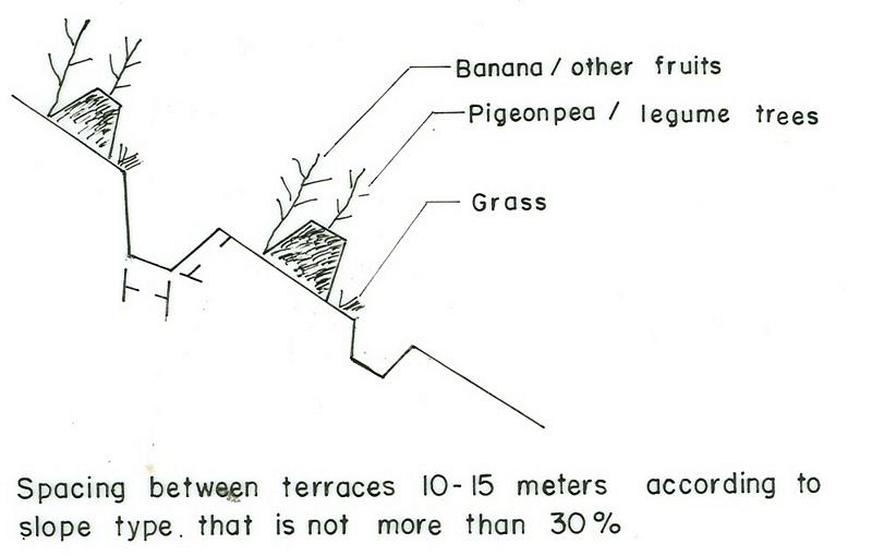
4.2 Technical specifications/ explanations of technical drawing
SNNPR
Technical knowledge required for field staff / advisors: moderate
Technical knowledge required for land users: high
Main technical functions: control of dispersed runoff: retain / trap, control of concentrated runoff: retain / trap
Secondary technical functions: control of concentrated runoff: drain / divert, increase of infiltration, increase / maintain water stored in soil, water harvesting / increase water supply
Early planting
Material/ species: maize, teff
Remarks: broad casting, row planting
Mixed cropping / intercropping
Material/ species: maize with beans
Quantity/ density: 25kg/ha
Remarks: row planting
Agronomic measure: sweet potato
Quantity/ density: 55000
Legume inter-planting
Remarks: row planting
Contour tillage
Remarks: furrow formation
Aligned: -contour
Vegetative material: G : grass
Vertical interval between rows / strips / blocks (m): 1m
Spacing between rows / strips / blocks (m): 7m
In blocks
Vegetative material: T : trees / shrubs, F : fruit trees / shrubs
Vertical interval between rows / strips / blocks (m): 1
Spacing between rows / strips / blocks (m): 33
Trees/ shrubs species: sesbania, Shinus molle
Fruit trees / shrubs species: mango, avocado, papaya
Perennial crops species: coffee
Grass species: elephant grass, phalaris
Slope (which determines the spacing indicated above): 8.00%
Gradient along the rows / strips: 0.00%
Diversion ditch/ drainage
Depth of ditches/pits/dams (m): 0.75
Width of ditches/pits/dams (m): 1.5
Length of ditches/pits/dams (m): 300
Height of bunds/banks/others (m): 0.75
Width of bunds/banks/others (m): 1.2
Length of bunds/banks/others (m): 300
Bund/ bank: level
Vertical interval between structures (m): 1-1.5
Spacing between structures (m): 10-20
Depth of ditches/pits/dams (m): 0.5
Width of ditches/pits/dams (m): 0.5
Length of ditches/pits/dams (m): 100
Height of bunds/banks/others (m): 0.6
Width of bunds/banks/others (m): 1.2m
Length of bunds/banks/others (m): 100
Construction material (earth): At the time of ditch construction, the excavated soil is used to make the embankment.
Construction material (stone): Stones are used for ditch pavement
Slope (which determines the spacing indicated above): 20%
Lateral gradient along the structure: 0%
Vegetation is used for stabilisation of structures.
Other type of management: change of management / intensity level
4.3 General information regarding the calculation of inputs and costs
other/ national currency (specify):
Birr
Indicate exchange rate from USD to local currency (if relevant): 1 USD =:
8.6
Indicate average wage cost of hired labour per day:
0.70
4.4 Establishment activities
| Activity | Type of measure | Timing | |
|---|---|---|---|
| 1. | Collecting of planting materials (seeds) | Vegetative | during rainy season |
| 2. | Planting on bunds | Vegetative | during rainy season |
| 3. | Cultivation | Vegetative | during rainy season |
| 4. | Fencing | Vegetative | during rainy season |
| 5. | Survey | Structural | dry season |
| 6. | Layout | Structural | dry season |
| 7. | Constructing the terrace | Structural | dry season |
| 8. | Stablization of terrace | Structural | rain season |
| 9. | control grazing | Management |
4.5 Costs and inputs needed for establishment
| Specify input | Unit | Quantity | Costs per Unit | Total costs per input | % of costs borne by land users | |
|---|---|---|---|---|---|---|
| Labour | Labour | ha | 1.0 | 140.0 | 140.0 | 100.0 |
| Labour | Person days | ha | 1.0 | 29.0 | 29.0 | |
| Equipment | Animal traction | ha | 1.0 | 101.0 | 101.0 | |
| Equipment | Tools | ha | 1.0 | 47.0 | 47.0 | |
| Plant material | Seeds | ha | 1.0 | 24.0 | 24.0 | |
| Fertilizers and biocides | Fertilizer | ha | 1.0 | 55.0 | 55.0 | |
| Total costs for establishment of the Technology | 396.0 | |||||
Comments:
Duration of establishment phase: 12 month(s)
4.6 Maintenance/ recurrent activities
| Activity | Type of measure | Timing/ frequency | |
|---|---|---|---|
| 1. | Land preparation | Agronomic | before and onset of rains / each cropping season |
| 2. | Planting/Sowing | Agronomic | during rains / each cropping season |
| 3. | Weeding | Agronomic | during rains / each cropping season |
| 4. | Harvesting | Agronomic | dry season / each cropping season |
| 5. | Replanting | Vegetative | rainy season /as needed |
| 6. | Replanting | Structural | rainy season/annual |
| 7. | Sediment removal | Structural | offset of rain/annual |
4.7 Costs and inputs needed for maintenance/ recurrent activities (per year)
| Specify input | Unit | Quantity | Costs per Unit | Total costs per input | % of costs borne by land users | |
|---|---|---|---|---|---|---|
| Labour | Labour | ha | 1.0 | 14.0 | 14.0 | 100.0 |
| Labour | Person days | ha | 1.0 | 29.0 | 29.0 | |
| Equipment | Animal traction | ha | 1.0 | 101.0 | 101.0 | |
| Plant material | Seeds | ha | 1.0 | 24.0 | 24.0 | |
| Fertilizers and biocides | Fertilizer | ha | 1.0 | 55.0 | 55.0 | |
| Total costs for maintenance of the Technology | 223.0 | |||||
Comments:
Machinery/ tools: Shovel and hoe
The cost estimation is made for 1 km length bund in a hectare of land planted with maize.
4.8 Most important factors affecting the costs
Describe the most determinate factors affecting the costs:
Labour cost increases or decreases per hectare of land depending on land form, type and depth of the soil. Cost of construction with increase in slope.
5. Natural and human environment
5.1 Climate
Annual rainfall
- < 250 mm
- 251-500 mm
- 501-750 mm
- 751-1,000 mm
- 1,001-1,500 mm
- 1,501-2,000 mm
- 2,001-3,000 mm
- 3,001-4,000 mm
- > 4,000 mm
Specifications/ comments on rainfall:
900-1400 mm, in good years rains up to 1440 mm are received, quite good enough for perennial crops such as Enset, coffee and fruit trees.
Agro-climatic zone
- humid
- sub-humid
5.2 Topography
Slopes on average:
- flat (0-2%)
- gentle (3-5%)
- moderate (6-10%)
- rolling (11-15%)
- hilly (16-30%)
- steep (31-60%)
- very steep (>60%)
Landforms:
- plateau/plains
- ridges
- mountain slopes
- hill slopes
- footslopes
- valley floors
Altitudinal zone:
- 0-100 m a.s.l.
- 101-500 m a.s.l.
- 501-1,000 m a.s.l.
- 1,001-1,500 m a.s.l.
- 1,501-2,000 m a.s.l.
- 2,001-2,500 m a.s.l.
- 2,501-3,000 m a.s.l.
- 3,001-4,000 m a.s.l.
- > 4,000 m a.s.l.
Comments and further specifications on topography:
Altitudinal zone: 1501-2000 m a.s.l. ( over 70% falls in this category, ranked 1), 2000-2500 m a.s.l. (ranked 2) and 1001-1500 m a.s.l. as well as 2501-3000 m a.s.l. (both ranked 3)
Landforms: Ridges (ranked 2) and mountain slopes as well as valley floors (both ranked 3)
Slopes on average: Hilly (soils have better fertility, ranked 1), rolling (ranked 2) and moderate (ranked 3)
5.3 Soils
Soil depth on average:
- very shallow (0-20 cm)
- shallow (21-50 cm)
- moderately deep (51-80 cm)
- deep (81-120 cm)
- very deep (> 120 cm)
Soil texture (topsoil):
- medium (loamy, silty)
- fine/ heavy (clay)
Topsoil organic matter:
- low (<1%)
If available, attach full soil description or specify the available information, e.g. soil type, soil PH/ acidity, Cation Exchange Capacity, nitrogen, salinity etc.
Soil depth on average: Moderately deep (most of the soils (60%) have moderately deep soils, ranked 1), deep (25 % SWC area, ranked 2) and shallow (soils on steep slopes (15%), ranked 3)
Soil fertility: Low (continuous cropping-long period cultivation, ranked 1), very low (shallow soils, ranked 2) and medium (ranked 3)
Topsoil organic matter: Low (no crop yield with out fertilizers applied, ranked 1), medium (ranked 2) and high (flat slopes and around harvested, ranked 3)
Soil water storage capacity: High (ranked 1), very high (ranked 2) and medium (ranked 3)
5.6 Characteristics of land users applying the Technology
Market orientation of production system:
- subsistence (self-supply)
- mixed (subsistence/ commercial
Off-farm income:
- less than 10% of all income
Relative level of wealth:
- very poor
- poor
Level of mechanization:
- manual work
- animal traction
Indicate other relevant characteristics of the land users:
Population density: 200-500 persons/km2
Annual population growth: 3% - 4%
20% of the land users are average wealthy and own 40% of the land (own few livestock).
45% of the land users are poor and own 25% of the land (have small land holding).
35% of the land users are poor and own 35% of the land (no/too little land, no property).
Off-farm income specification: Most of the people in the area are engaged in agricultural activities and only few people are engaged on off-farm activities.
Level of mechanization: Animal traction (most of the land users, ranked 1) and manual work (few land useres, ranked 2)
Market oriantation cropland: Subsistence (The produce is only enough for family consumption)
5.7 Average area of land owned or leased by land users applying the Technology
- < 0.5 ha
- 0.5-1 ha
- 1-2 ha
- 2-5 ha
- 5-15 ha
- 15-50 ha
- 50-100 ha
- 100-500 ha
- 500-1,000 ha
- 1,000-10,000 ha
- > 10,000 ha
Comments:
Land holding is very small and it is 0.50 ha per household
5.8 Land ownership, land use rights, and water use rights
Land ownership:
- state
6. Impacts and concluding statements
6.1 On-site impacts the Technology has shown
Socio-economic impacts
Production
crop production
fodder production
Comments/ specify:
the bund is planted with grasses and legume trees
fodder quality
Comments/ specify:
the bund is planted with grasses and legume trees
wood production
production area
land management
Income and costs
farm income
Socio-cultural impacts
SLM/ land degradation knowledge
Ecological impacts
Water cycle/ runoff
surface runoff
Quantity before SLM:
65
Quantity after SLM:
20
Soil
soil moisture
soil cover
soil loss
Quantity before SLM:
20
Quantity after SLM:
1
Other ecological impacts
Soil fertility
6.2 Off-site impacts the Technology has shown
reliable and stable stream flows in dry season
downstream flooding
downstream siltation
groundwater/ river pollution
6.4 Cost-benefit analysis
How do the benefits compare with the establishment costs (from land users’ perspective)?
Short-term returns:
positive
Long-term returns:
very positive
How do the benefits compare with the maintenance/ recurrent costs (from land users' perspective)?
Short-term returns:
positive
Long-term returns:
positive
6.5 Adoption of the Technology
Of all those who have adopted the Technology, how many have did so spontaneously, i.e. without receiving any material incentives/ payments?
- 10-50%
Comments:
75% of land user families have adopted the Technology with external material support
Comments on acceptance with external material support: estimates
25% of land user families have adopted the Technology without any external material support
Comments on spontaneous adoption: estimates
There is a moderate trend towards spontaneous adoption of the Technology
Comments on adoption trend: SWC intervention is an activity that aims at controlling erosion, improving soil moisture and productivity per unit area of land.
6.7 Strengths/ advantages/ opportunities of the Technology
| Strengths/ advantages/ opportunities in the land user’s view |
|---|
|
Controls erosion How can they be sustained / enhanced? use of multipurpose plant species for bund stablization. |
| Strengths/ advantages/ opportunities in the compiler’s or other key resource person’s view |
|---|
|
Effective in controlling erosion How can they be sustained / enhanced? quality and technical standard should be kept. |
|
Fast to develop to bench terrace How can they be sustained / enhanced? require continuous maintainance |
6.8 Weaknesses/ disadvantages/ risks of the Technology and ways of overcoming them
| Weaknesses/ disadvantages/ risks in the compiler’s or other key resource person’s view | How can they be overcome? |
|---|---|
| harbour rodents | provision of pesticides |
| labour intensive | provision of hand tools and incentives |
| no short time impact | introduce multipurpose planting material |
Links and modules
Expand all Collapse allLinks
Incentive based CCPPA [Ethiopia]
The participation of the communities in the planning implementation and evaluation of SWC activities and provided with food for work as an insentive to encourage participation.
- Compiler: Daniel Danano
Modules
No modules