Vegetated Fanya juu [เอธิโอเปีย]
- ผู้สร้างสรรค์:
- การอัพเดท:
- ผู้รวบรวม: Unknown User
- ผู้เรียบเรียง: –
- ผู้ตรวจสอบ: Fabian Ottiger
Ye Masa Erken (Amharic)
technologies_1074 - เอธิโอเปีย
ดูส่วนย่อย
ขยายทั้งหมด ย่อทั้งหมด1. ข้อมูลทั่วไป
1.2 รายละเอียดที่ติดต่อได้ของผู้รวบรวมและองค์กรที่เกี่ยวข้องในการประเมินและการจัดเตรียมทำเอกสารของเทคโนโลยี
วิทยากรหลัก
ผู้เชี่ยวชาญ SLM:
Fikadu
0465553936
SNNPR, Omo Sheleko Agricultural and Rural Development Office
Mudula
เอธิโอเปีย
ชื่อขององค์กรซึ่งอำนวยความสะดวกในการทำเอกสารหรือการประเมินเทคโนโลยี (ถ้าเกี่ยวข้อง)
SNNPR Bureau of Agriculture - เอธิโอเปีย1.3 เงื่อนไขการใช้ข้อมูลที่ได้บันทึกผ่านทาง WOCAT
วันที่เก็บรวบรวมข้อมูล(ภาคสนาม) :
30/05/2011
ผู้รวบรวมและวิทยากรหลักยอมรับเงื่อนไขเกี่ยวกับการใช้ข้อมูลที่ถูกบันทึกผ่านทาง WOCAT:
ใช่
1.5 อ้างอิงไปที่แบบสอบถามเรื่องแนวทาง SLM

Incentive based CCPPA [เอธิโอเปีย]
The participation of the communities in the planning implementation and evaluation of SWC activities and provided with food for work as an insentive to encourage participation.
- ผู้รวบรวม: Daniel Danano
2. การอธิบายลักษณะของเทคโนโลยี SLM
2.1 การอธิบายแบบสั้น ๆ ของเทคโนโลยี
คำจำกัดความของเทคโนโลยี:
A terrace constructed along the contour with the embankment above the basin to prevent/control or reduce runoff.
2.2 การอธิบายแบบละเอียดของเทคโนโลยี
คำอธิบาย:
The technology is integrated with cutoff drain, stablized by grass and trees and also integrated with some agronomic measures such as inter cropping, crop rotation and green manuring.
Purpose of the Technology: It aims at controlling runoff velocity and soil erosion, changes the slope inclination, recharge ground water, conserve soil moisture and increase the productivity per unit of land.
Establishment / maintenance activities and inputs: It is done or maintained on self-help bases. When the basin is filled up with sediment or it is damaged by over flowing of runoff, repair work is undertaken.
Natural / human environment: It is environmentaly sound, conducive and accepted by the communit
2.5 ประเทศภูมิภาค หรือสถานที่ตั้งที่เทคโนโลยีได้นำไปใช้และได้รับการครอบคลุมโดยการประเมินนี้
ประเทศ:
เอธิโอเปีย
ภูมิภาค/รัฐ/จังหวัด:
NNNPR/Kembata Tembaro Zone
ข้อมูลจำเพาะเพิ่มเติมของสถานที่ตั้ง :
Omo Sheleko woreda
Map
×2.6 วันที่การดำเนินการ
ถ้าไม่รู้ปีที่แน่นอน ให้ระบุวันที่โดยประมาณ:
- น้อยกว่า 10 ปี (ไม่นานนี้)
2.7 คำแนะนำของเทคโนโลยี
ให้ระบุว่าเทคโนโลยีถูกแนะนำเข้ามาอย่างไร:
- ทางโครงการหรือจากภายนอก
ความคิดเห็น (ประเภทของโครงการ เป็นต้น) :
from expriences in other countries and also other woredas in the country.
3. การจัดประเภทของเทคโนโลยี SLM
3.1 วัตถุประสงค์หลักของเทคโนโลยี
- ลด ป้องกัน ฟื้นฟู การเสื่อมโทรมของที่ดิน
3.2 ประเภทของการใช้ที่ดินในปัจจุบันที่ได้นำเทคโนโลยีไปใช้

พื้นที่ปลูกพืช
- การปลูกพืชล้มลุกอายุปีเดียว
- การปลูกพืชยืนต้นที่ไม่มีเนื้อไม้
พืชหลัก (พืชเศรษฐกิจและพืชอาหาร):
Major cash crop annual cropping: Teff, wheat
Major food crop annual cropping: sorghum, maize
Major cash crop perennial (non-woody) cropping: Coffee
Major food crop perennial (non-woody) cropping: Fruit trees
แสดงความคิดเห็น:
Major land use problems (compiler’s opinion): Low soil fertility, land degradation, decline in productivity.
Major land use problems (land users’ perception): Productivity has highly declined, high amounts of inputs required to improve the soil fertility.
Type of cropping system and major crops comments: Teff - Maize - Beans - Sweet potato
3.3 ข้อมูลเพิ่มเติมเกี่ยวกับการใช้ที่ดิน
การใช้น้ำของที่ดินที่มีการใช้เทคโนโลยีอยู่:
- จากน้ำฝน
จำนวนของฤดูเพาะปลูกต่อปี:
- 2
ระบุ:
Longest growing period in days: 240 Longest growing period from month to month: Mar - Oct Second longest growing period in days: 180 Second longest growing period from month to month: Jun - Dec
3.4 กลุ่ม SLM ที่ตรงกับเทคโนโลยีนี้
- มาตรการปลูกพืชขวางความลาดชัน (cross-slope measure)
3.5 กระจายตัวของเทคโนโลยี
แสดงความคิดเห็น:
Total area covered by the SLM Technology is 15.18 m2.
The technology is integrated with different biological measures such as bund stablized by grass, legumes and tree species and supplimented with cutoff drain.
3.6 มาตรการ SLM ที่ประกอบกันเป็นเทคโนโลยี
3.7 รูปแบบหลักของการเสื่อมโทรมของที่ดินที่ได้รับการแก้ไขโดยเทคโนโลยี

การกัดกร่อนของดินโดยน้ำ
- Wt (Loss of topsoil): การสูญเสียดินชั้นบนหรือการกัดกร่อนที่ผิวดิน
- Wg (Gully erosion): การกัดกร่อนแบบร่องธารหรือการทำให้เกิดร่องน้ำเซาะ

การเสื่อมโทรมของดินทางด้านเคมี
- Cn (Fertility decline): ความอุดมสมบูรณ์และปริมาณอินทรียวัตถุในดินถูกทำให้ลดลงไป (ไม่ได้เกิดจากสาเหตุการกัดกร่อน)
แสดงความคิดเห็น:
Main type of degradation addressed: Wt: loss of topsoil / surface erosion
Secondary types of degradation addressed: Wg: gully erosion / gullying, Cn: fertility decline and reduced organic matter content
3.8 การป้องกัน การลดลง หรือการฟื้นฟูความเสื่อมโทรมของที่ดิน
ระบุเป้าหมายของเทคโนโลยีกับความเสื่อมโทรมของที่ดิน:
- ลดความเสื่อมโทรมของดิน
แสดงความคิดเห็น:
Secondary goals: prevention of land degradation, rehabilitation / reclamation of denuded land
4. ข้อมูลจำเพาะด้านเทคนิค กิจกรรมการนำไปปฏิบัติใช้ ปัจจัยนำเข้า และค่าใช้จ่าย
4.1 แบบแปลนทางเทคนิคของเทคโนโลยี
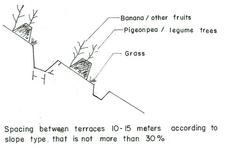
4.2 ข้อมูลจำเพาะด้านเทคนิคและการอธิบายแบบแปลนทางเทคนิค
SNNPR
Technical knowledge required for field staff / advisors: moderate
Technical knowledge required for land users: high
Main technical functions: control of dispersed runoff: retain / trap, control of concentrated runoff: retain / trap
Secondary technical functions: control of concentrated runoff: drain / divert, increase of infiltration, increase / maintain water stored in soil, water harvesting / increase water supply
Early planting
Material/ species: maize, teff
Remarks: broad casting, row planting
Mixed cropping / intercropping
Material/ species: maize with beans
Quantity/ density: 25kg/ha
Remarks: row planting
Agronomic measure: sweet potato
Quantity/ density: 55000
Legume inter-planting
Remarks: row planting
Contour tillage
Remarks: furrow formation
Aligned: -contour
Vegetative material: G : grass
Vertical interval between rows / strips / blocks (m): 1m
Spacing between rows / strips / blocks (m): 7m
In blocks
Vegetative material: T : trees / shrubs, F : fruit trees / shrubs
Vertical interval between rows / strips / blocks (m): 1
Spacing between rows / strips / blocks (m): 33
Trees/ shrubs species: sesbania, Shinus molle
Fruit trees / shrubs species: mango, avocado, papaya
Perennial crops species: coffee
Grass species: elephant grass, phalaris
Slope (which determines the spacing indicated above): 8.00%
Gradient along the rows / strips: 0.00%
Diversion ditch/ drainage
Depth of ditches/pits/dams (m): 0.75
Width of ditches/pits/dams (m): 1.5
Length of ditches/pits/dams (m): 300
Height of bunds/banks/others (m): 0.75
Width of bunds/banks/others (m): 1.2
Length of bunds/banks/others (m): 300
Bund/ bank: level
Vertical interval between structures (m): 1-1.5
Spacing between structures (m): 10-20
Depth of ditches/pits/dams (m): 0.5
Width of ditches/pits/dams (m): 0.5
Length of ditches/pits/dams (m): 100
Height of bunds/banks/others (m): 0.6
Width of bunds/banks/others (m): 1.2m
Length of bunds/banks/others (m): 100
Construction material (earth): At the time of ditch construction, the excavated soil is used to make the embankment.
Construction material (stone): Stones are used for ditch pavement
Slope (which determines the spacing indicated above): 20%
Lateral gradient along the structure: 0%
Vegetation is used for stabilisation of structures.
Other type of management: change of management / intensity level
4.3 ข้อมูลทั่วไปเกี่ยวกับการคำนวณปัจจัยนำเข้าและค่าใช้จ่าย
อื่นๆ หรือสกุลเงินประจำชาติ (ระบุ):
Birr
ระบุอัตราแลกเปลี่ยนจากดอลลาร์สหรัฐเป็นสกุลเงินท้องถิ่น (ถ้าเกี่ยวข้อง) คือ 1 เหรียญสหรัฐ =:
8.6
ระบุค่าเฉลี่ยของค่าจ้างในการจ้างแรงงานต่อวัน:
0.70
4.4 กิจกรรมเพื่อการจัดตั้ง
| กิจกรรม | ประเภทของมาตรการ | ช่วงเวลาดำเนินการ | |
|---|---|---|---|
| 1. | Collecting of planting materials (seeds) | ด้วยวิธีพืช | during rainy season |
| 2. | Planting on bunds | ด้วยวิธีพืช | during rainy season |
| 3. | Cultivation | ด้วยวิธีพืช | during rainy season |
| 4. | Fencing | ด้วยวิธีพืช | during rainy season |
| 5. | Survey | ด้วยโครงสร้าง | dry season |
| 6. | Layout | ด้วยโครงสร้าง | dry season |
| 7. | Constructing the terrace | ด้วยโครงสร้าง | dry season |
| 8. | Stablization of terrace | ด้วยโครงสร้าง | rain season |
| 9. | control grazing | ด้วยการจัดการ |
4.5 ค่าใช้จ่ายของปัจจัยนำเข้าที่จำเป็นสำหรับการจัดตั้ง
| ปัจจัยนำเข้า | หน่วย | ปริมาณ | ค่าใช้จ่ายต่อหน่วย | ค่าใช้จ่ายทั้งหมดต่อปัจจัยนำเข้า | %ของค่าใช้จ่ายที่ก่อให้เกิดขึ้นโดยผู้ใช้ที่ดิน | |
|---|---|---|---|---|---|---|
| แรงงาน | Labour | ha | 1.0 | 140.0 | 140.0 | 100.0 |
| แรงงาน | Person days | ha | 1.0 | 29.0 | 29.0 | |
| อุปกรณ์ | Animal traction | ha | 1.0 | 101.0 | 101.0 | |
| อุปกรณ์ | Tools | ha | 1.0 | 47.0 | 47.0 | |
| วัสดุด้านพืช | Seeds | ha | 1.0 | 24.0 | 24.0 | |
| ปุ๋ยและสารฆ่า/ยับยั้งการเจริญเติบโตของสิ่งมีชีวิต (ไบโอไซด์) | Fertilizer | ha | 1.0 | 55.0 | 55.0 | |
| ค่าใช้จ่ายทั้งหมดของการจัดตั้งเทคโนโลยี | 396.0 | |||||
แสดงความคิดเห็น:
Duration of establishment phase: 12 month(s)
4.6 การบำรุงรักษาสภาพหรือกิจกรรมที่เกิดขึ้นเป็นประจำ
| กิจกรรม | ประเภทของมาตรการ | ช่วงระยะเวลา/ความถี่ | |
|---|---|---|---|
| 1. | Land preparation | จัดการพืช | before and onset of rains / each cropping season |
| 2. | Planting/Sowing | จัดการพืช | during rains / each cropping season |
| 3. | Weeding | จัดการพืช | during rains / each cropping season |
| 4. | Harvesting | จัดการพืช | dry season / each cropping season |
| 5. | Replanting | ด้วยวิธีพืช | rainy season /as needed |
| 6. | Replanting | ด้วยโครงสร้าง | rainy season/annual |
| 7. | Sediment removal | ด้วยโครงสร้าง | offset of rain/annual |
4.7 ค่าใช้จ่ายของปัจจัยนำเข้าและกิจกรรมที่เกิดขึ้นเป็นประจำที่ต้องการการบำรุงรักษา (ต่อปี)
| ปัจจัยนำเข้า | หน่วย | ปริมาณ | ค่าใช้จ่ายต่อหน่วย | ค่าใช้จ่ายทั้งหมดต่อปัจจัยนำเข้า | %ของค่าใช้จ่ายที่ก่อให้เกิดขึ้นโดยผู้ใช้ที่ดิน | |
|---|---|---|---|---|---|---|
| แรงงาน | Labour | ha | 1.0 | 14.0 | 14.0 | 100.0 |
| แรงงาน | Person days | ha | 1.0 | 29.0 | 29.0 | |
| อุปกรณ์ | Animal traction | ha | 1.0 | 101.0 | 101.0 | |
| วัสดุด้านพืช | Seeds | ha | 1.0 | 24.0 | 24.0 | |
| ปุ๋ยและสารฆ่า/ยับยั้งการเจริญเติบโตของสิ่งมีชีวิต (ไบโอไซด์) | Fertilizer | ha | 1.0 | 55.0 | 55.0 | |
| ค่าใช้จ่ายทั้งหมดของการบำรุงรักษาสภาพเทคโนโลยี | 223.0 | |||||
แสดงความคิดเห็น:
Machinery/ tools: Shovel and hoe
The cost estimation is made for 1 km length bund in a hectare of land planted with maize.
4.8 ปัจจัยสำคัญที่สุดที่มีผลกระทบต่อค่าใช้จ่าย
ปัจจัยสำคัญที่สุดที่มีผลกระทบต่อค่าใช้จ่ายต่างๆ:
Labour cost increases or decreases per hectare of land depending on land form, type and depth of the soil. Cost of construction with increase in slope.
5. สิ่งแวดล้อมทางธรรมชาติและของมนุษย์
5.1 ภูมิอากาศ
ฝนประจำปี
- < 250 ม.ม.
- 251-500 ม.ม.
- 501-750 ม.ม.
- 751-1,000 ม.ม.
- 1,001-1,500 ม.ม.
- 1,501-2,000 ม.ม.
- 2,001-3,000 ม.ม.
- 3,001-4,000 ม.ม.
- > 4,000 ม.ม.
ข้อมูลจำเพาะ/ความคิดเห็นเรื่องปริมาณน้ำฝน:
900-1400 mm, in good years rains up to 1440 mm are received, quite good enough for perennial crops such as Enset, coffee and fruit trees.
เขตภูมิอากาศเกษตร
- ชื้น
- กึ่งชุ่มชื้น
5.2 สภาพภูมิประเทศ
ค่าเฉลี่ยความลาดชัน:
- ราบเรียบ (0-2%)
- ลาดที่ไม่ชัน (3-5%)
- ปานกลาง (6-10%)
- เป็นลูกคลื่น (11-15%)
- เป็นเนิน (16-30%)
- ชัน (31-60%)
- ชันมาก (>60%)
ธรณีสัณฐาน:
- ที่ราบสูง/ที่ราบ
- สันเขา
- ไหล่เขา
- ไหล่เนินเขา
- ตีนเนิน
- หุบเขา
ระดับความสูง:
- 0-100 เมตร
- 101-500 เมตร
- 501-1,000 เมตร
- 1,001-1,500 เมตร
- 1,501-2,000 เมตร
- 2,001-2,500 เมตร
- 2,501-3,000 เมตร
- 3,001-4,000 เมตร
- > 4,000 เมตร
ความคิดเห็นและข้อมูลจำเพาะเพิ่มเติมเรื่องสภาพภูมิประเทศ:
Altitudinal zone: 1501-2000 m a.s.l. ( over 70% falls in this category, ranked 1), 2000-2500 m a.s.l. (ranked 2) and 1001-1500 m a.s.l. as well as 2501-3000 m a.s.l. (both ranked 3)
Landforms: Ridges (ranked 2) and mountain slopes as well as valley floors (both ranked 3)
Slopes on average: Hilly (soils have better fertility, ranked 1), rolling (ranked 2) and moderate (ranked 3)
5.3 ดิน
ค่าเฉลี่ยความลึกของดิน:
- ตื้นมาก (0-20 ซ.ม.)
- ตื้น (21-50 ซ.ม.)
- ลึกปานกลาง (51-80 ซ.ม.)
- ลึก (81-120 ซ.ม.)
- ลึกมาก (>120 ซ.ม.)
เนื้อดิน (ดินชั้นบน):
- ปานกลาง (ดินร่วน ทรายแป้ง)
- ละเอียด/หนัก (ดินเหนียว)
อินทรียวัตถุในดิน:
- ต่ำ (<1%)
(ถ้ามี) ให้แนบคำอธิบายเรื่องดินแบบเต็มหรือระบุข้อมูลที่มีอยู่ เช่น ชนิดของดิน ค่า pH ของดินหรือความเป็นกรดของดิน ความสามารถในการแลกเปลี่ยนประจุบวก ไนโตรเจน ความเค็ม เป็นต้น:
Soil depth on average: Moderately deep (most of the soils (60%) have moderately deep soils, ranked 1), deep (25 % SWC area, ranked 2) and shallow (soils on steep slopes (15%), ranked 3)
Soil fertility: Low (continuous cropping-long period cultivation, ranked 1), very low (shallow soils, ranked 2) and medium (ranked 3)
Topsoil organic matter: Low (no crop yield with out fertilizers applied, ranked 1), medium (ranked 2) and high (flat slopes and around harvested, ranked 3)
Soil water storage capacity: High (ranked 1), very high (ranked 2) and medium (ranked 3)
5.6 ลักษณะของผู้ใช้ที่ดินที่นำเทคโนโลยีไปปฏิบัติใช้
แนวทางการตลาดของระบบการผลิต:
- เพื่อการยังชีพ (หาเลี้ยงตนเอง)
- ผสม (การเลี้ยงชีพ/ทำการค้า)
รายได้ที่มาจากนอกฟาร์ม:
- < 10% ของรายได้ทั้งหมด
ระดับของความมั่งคั่งโดยเปรียบเทียบ:
- ยากจนมาก
- จน
ระดับของการใช้เครื่องจักรกล:
- งานที่ใช้แรงกาย
- การใช้กำลังจากสัตว์
ระบุลักษณะอื่นๆที่เกี่ยวข้องของผู้ใช้ที่ดิน:
Population density: 200-500 persons/km2
Annual population growth: 3% - 4%
20% of the land users are average wealthy and own 40% of the land (own few livestock).
45% of the land users are poor and own 25% of the land (have small land holding).
35% of the land users are poor and own 35% of the land (no/too little land, no property).
Off-farm income specification: Most of the people in the area are engaged in agricultural activities and only few people are engaged on off-farm activities.
Level of mechanization: Animal traction (most of the land users, ranked 1) and manual work (few land useres, ranked 2)
Market oriantation cropland: Subsistence (The produce is only enough for family consumption)
5.7 พื้นที่เฉลี่ยของที่ดินที่เป็นเจ้าของหรือเช่าโดยผู้ใช้ที่ดินที่นำเทคโนโลยีไปปฏิบัติใช้
- < 0.5 เฮกตาร์
- 0.5-1 เฮกตาร์
- 1-2 เฮกตาร์
- 2-5 เฮกตาร์
- 5-15 เฮกตาร์
- 15-50 เฮกตาร์
- 50-100 เฮกตาร์
- 100-500 เฮกตาร์
- 500-1,000 เฮกตาร์
- 1,000-10,000 เฮกตาร์
- >10,000 เฮกตาร์
แสดงความคิดเห็น:
Land holding is very small and it is 0.50 ha per household
5.8 กรรมสิทธิ์ในที่ดิน สิทธิในการใช้ที่ดินและสิทธิในการใช้น้ำ
กรรมสิทธิ์ในที่ดิน:
- รัฐ
6. ผลกระทบและสรุปคำบอกกล่าว
6.1 ผลกระทบในพื้นที่ดำเนินการ (On-site) จากการใช้เทคโนโลยี
ผลกระทบทางด้านเศรษฐกิจและสังคม
การผลิต
การผลิตพืชผล
การผลิตพืชที่ใช้เลี้ยงปศุสัตว์
แสดงความคิดเห็น/ระบุ:
the bund is planted with grasses and legume trees
คุณภาพพืชที่ใช้เลี้ยงปศุสัตว์
แสดงความคิดเห็น/ระบุ:
the bund is planted with grasses and legume trees
การผลิตไม้
พื้นที่สำหรับการผลิต
การจัดการที่ดิน
รายได้และค่าใช้จ่าย
รายได้จากฟาร์ม
ผลกระทบด้านสังคมวัฒนธรรมอื่น ๆ
SLM หรือความรู้เรื่องความเสื่อมโทรมของที่ดิน
ผลกระทบด้านนิเวศวิทยา
วัฐจักรน้ำหรือน้ำบ่า
น้ำไหลบ่าที่ผิวดิน
จำนวนก่อน SLM:
65
หลังจาก SLM:
20
ดิน
ความชื้นในดิน
สิ่งปกคลุมดิน
การสูญเสียดิน
จำนวนก่อน SLM:
20
หลังจาก SLM:
1
ผลกระทบด้านนิเวศวิทยาอื่น ๆ
Soil fertility
6.2 ผลกระทบนอกพื้นที่ดำเนินการ (Off-site) จากการใช้เทคโนโลยี
การไหลของน้ำคงที่และสม่ำเสมอในช่วงฤดูแล้ง
น้ำท่วมพื้นที่ท้ายน้ำ
การทับถมของดินตะกอนพื้นที่ท้ายน้ำ
การเกิดมลพิษในน้ำบาดาลหรือแม่น้ำ
6.4 การวิเคราะห์ค่าใช้จ่ายและผลประโยชน์ที่ได้รับ
ผลประโยชน์ที่ได้รับเปรียบเทียบกับค่าใช้จ่ายในการจัดตั้งเป็นอย่างไร (จากมุมมองของผู้ใช้ที่ดิน)
ผลตอบแทนระยะสั้น:
ด้านบวก
ผลตอบแทนระยะยาว:
ด้านบวกอย่างมาก
ผลประโยชน์ที่ได้รับเปรียบเทียบกับค่าใช้จ่ายในการบำรุงรักษาหรือต้นทุนที่เกิดขึ้นซ้ำอีก เป็นอย่างไร (จากมุมมองของผู้ใช้ที่ดิน)
ผลตอบแทนระยะสั้น:
ด้านบวก
ผลตอบแทนระยะยาว:
ด้านบวก
6.5 การปรับตัวของเทคโนโลยี
จากทั้งหมดที่ได้รับเทคโนโลยีเข้ามามีจำนวนเท่าใดที่ทำแบบทันที โดยไม่ได้รับการจูงใจด้านวัสดุหรือการเงินใด ๆ:
- 10-50%
แสดงความคิดเห็น:
75% of land user families have adopted the Technology with external material support
Comments on acceptance with external material support: estimates
25% of land user families have adopted the Technology without any external material support
Comments on spontaneous adoption: estimates
There is a moderate trend towards spontaneous adoption of the Technology
Comments on adoption trend: SWC intervention is an activity that aims at controlling erosion, improving soil moisture and productivity per unit area of land.
6.7 จุดแข็ง / ข้อได้เปรียบ / โอกาสของเทคโนโลยี
| จุดแข็ง / ข้อได้เปรียบ / โอกาสในทัศนคติของผู้ใช้ที่ดิน |
|---|
|
Controls erosion How can they be sustained / enhanced? use of multipurpose plant species for bund stablization. |
| จุดแข็ง / ข้อได้เปรียบ / โอกาสในทัศนคติของผู้รวบรวมหรือวิทยากรหลัก |
|---|
|
Effective in controlling erosion How can they be sustained / enhanced? quality and technical standard should be kept. |
|
Fast to develop to bench terrace How can they be sustained / enhanced? require continuous maintainance |
6.8 จุดอ่อน / ข้อเสียเปรียบ / ความเสี่ยงของเทคโนโลยีและวิธีการแก้ไข
| จุดอ่อน / ข้อเสียเปรียบ / ความเสี่ยงในทัศนคติของผู้รวบรวมหรือวิทยากรหลัก | มีวิธีการแก้ไขได้อย่างไร |
|---|---|
| harbour rodents | provision of pesticides |
| labour intensive | provision of hand tools and incentives |
| no short time impact | introduce multipurpose planting material |
ลิงก์และโมดูล
ขยายทั้งหมด ย่อทั้งหมดลิงก์
Incentive based CCPPA [เอธิโอเปีย]
The participation of the communities in the planning implementation and evaluation of SWC activities and provided with food for work as an insentive to encourage participation.
- ผู้รวบรวม: Daniel Danano
โมดูล
ไม่มีโมดูล