Jessour [Tunisia]
- Creation:
- Update:
- Compiler: Mongi Ben Zaied
- Editor: –
- Reviewers: Deborah Niggli, Alexandra Gavilano
Jesser, Katra, Tabias (Arabic)
technologies_1013 - Tunisia
View sections
Expand all Collapse all1. General information
1.2 Contact details of resource persons and institutions involved in the assessment and documentation of the Technology
Key resource person(s)
SLM specialist:
Mongi Sghaier
Institut des Régions Arides IRA
Tunisia
SLM specialist:
Mongi Chniter
Commissariats Régionaux au Développement Agricole CRDA
Tunisia
SLM specialist:
Ouessar Mohammed
Institut des Régions Arides IRA
Tunisia
Name of project which facilitated the documentation/ evaluation of the Technology (if relevant)
DESIRE (EU-DES!RE)Name of project which facilitated the documentation/ evaluation of the Technology (if relevant)
Book project: Water Harvesting – Guidelines to Good Practice (Water Harvesting)Name of the institution(s) which facilitated the documentation/ evaluation of the Technology (if relevant)
Institut des Régions Arides de Médenine (Institut des Régions Arides de Médenine) - TunisiaName of the institution(s) which facilitated the documentation/ evaluation of the Technology (if relevant)
Commissariats Régionaux au Développement Agricole (CRDA) - Tunisia1.3 Conditions regarding the use of data documented through WOCAT
The compiler and key resource person(s) accept the conditions regarding the use of data documented through WOCAT:
Yes
1.5 Reference to Questionnaire(s) on SLM Approaches (documented using WOCAT)
Territorial Natural Resource Management Observatory [Tunisia]
A territorial natural resources management observatory is a scientific, technical and institutional system set up in a given area to observe, monitor and improve knowledge.
- Compiler: Wafa Saidi
Integrated Territorial Planning and Development Project (PADIT) [Tunisia]
The PADIT approach comprises a cross-cutting participatory methodology to rural development, rallying various stakeholders around a project, within a location, to identify the main economic areas of the rural community concerned, and draw up a prioritized list of actions to strengthen and support development efforts in their location.
- Compiler: Wafa Saidi
Collecte des eaux pluviales dans des citernes [Tunisia]
Les citernes sont construites soit par l’état dans les zones enclavées où l’approvisionnement en eaux potables et difficile voire impossible par le réseau de la Société Nationale d’Exploitation et de Distribution des Eaux (SONEDE) soit par des particuliers pour collecter les eaux de pluies. Ces ouvrages sont destinés à l’abreuvement …
- Compiler: Donia Mühlematter
Conservation des eaux et des sols suivant la … [Tunisia]
Les « jessour » sont développés dans les zones montagneuses de Gabès, Mede-nine et Tataouine où l’altitude varie entre 400 et 600 m et une pluviométrie an-nuelle variant entre 100 et 150 mm. Dans cette zone, on compte aux alentours de 35 000 jisr qui reçoit chacun annuellement un supplément …
- Compiler: Donia Mühlematter
Dryland watershed management approach [Tunisia]
Integrated land and water management approach, including vegetative, management, and agronomic measure
- Compiler: Naceur Mahdi
2. Description of the SLM Technology
2.1 Short description of the Technology
Definition of the Technology:
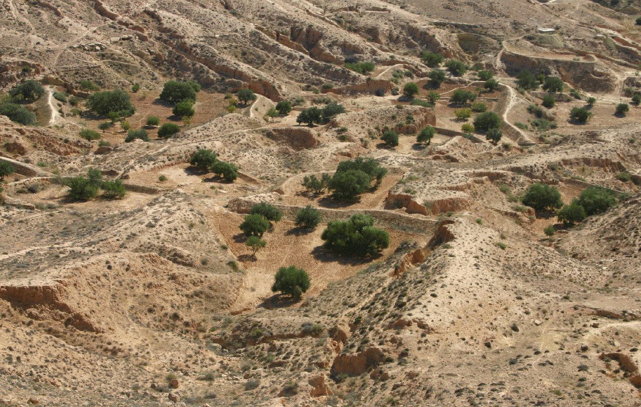
Jessour is an ancient runoff water harvesting technique widely practiced in the arid highlands
2.2 Detailed description of the Technology
Description:
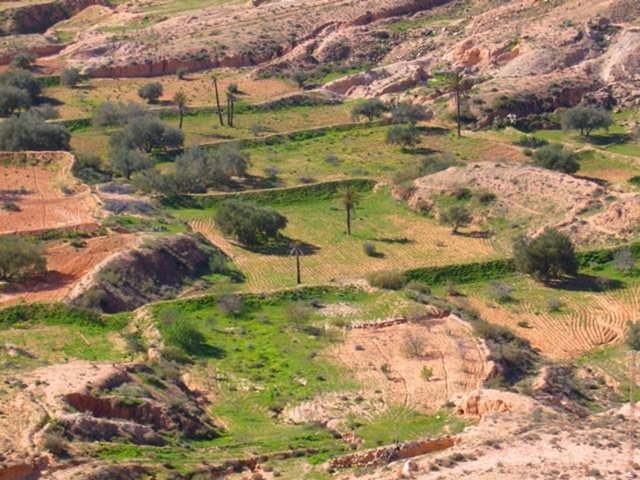
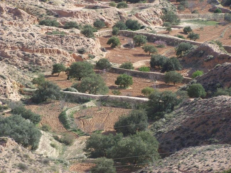
Jessour technology is generally practised in mountain dry regions (less than 200 mm annually) with medium to high slopes. This technology was behind the installation of very old olive orchards based on rainfed agriculture in rugged landscapes which allowed the local population not only to ensure self-sufficiency but also to provide neighbouring areas many agricultural produces (olive oil, dried figs, palm dates, etc.).
Jessour is the plural of jessr, which is a hydraulic unit made of three components: the impluvium, the terrace and the dyke. The impluvium or the catchment is the area which collects and conveys runoff water. It is bordered by a natural water divide line (a line that demarcates the boundary of a natural area or catchment, so that all the rain that falls on this area is concentrated and drained towards the same outlet). Each unit has its own impluvium, but can also receive excess water from upstream units. The terrace or cropping zone is the area in which farming is practised. It is formed progressively by the deposition of sediment. An artificial soil will then be created, which can be up to 5 m deep close to the dyke. Generally, fruit trees (e.g. olive, fig, almond, and date palm), legumes (e.g. pea, chickpeas, lentil, and faba bean) and barley and wheat are cultivated on these terraces.
Purpose of the Technology: Although the jessour technique was developed for the production of various agricultural crops, it now also plays three additional roles: (1) aquifer recharge, via runoff water infiltration into the terraces, (2) flood control and therefore the protection of infrastructure and towns built downstream, and (3) wind erosion control, by preventing sediment from reaching the downstream plains, where windspeeds can be particularly high.
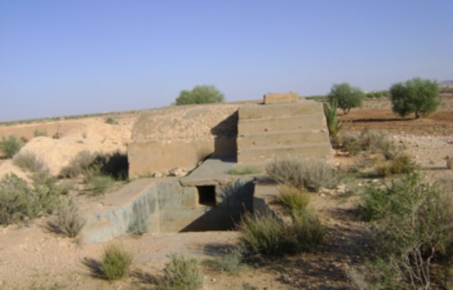
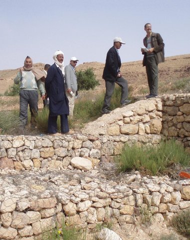
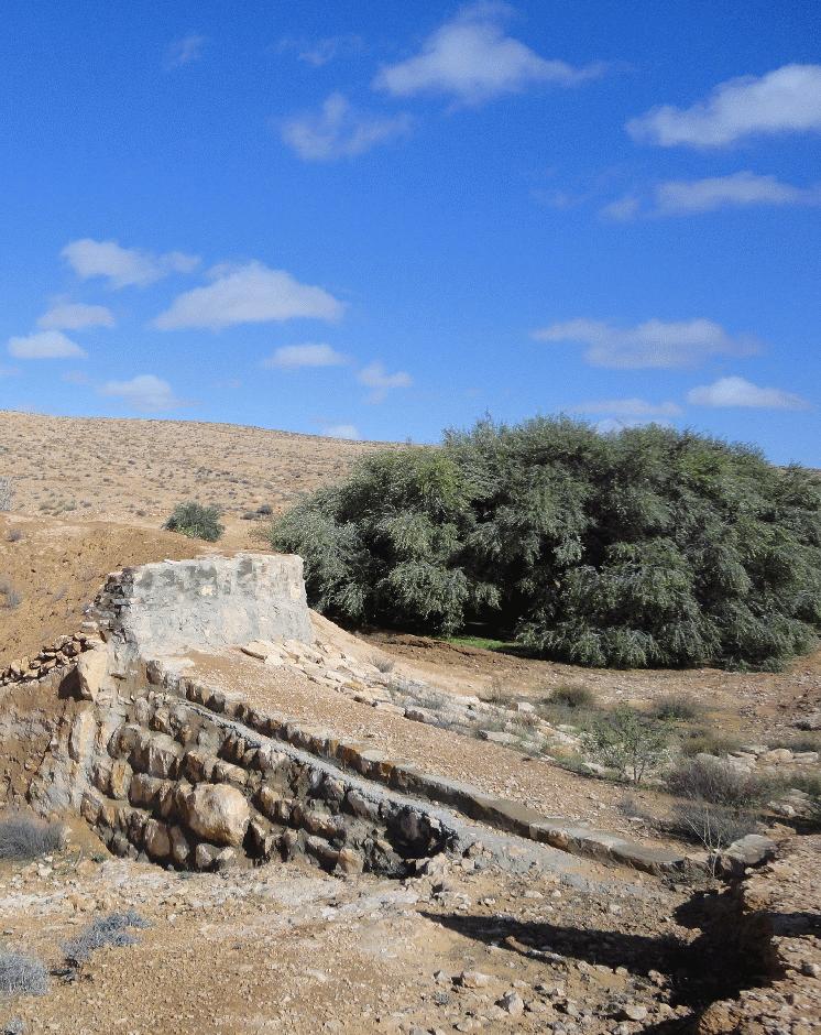
Establishment / maintenance activities and inputs: In the Jessour, a dyke (tabia, sed, katra) acts as a barrier used to hold back sediment and runoff water. Such dykes are made of earth, and are equipped with a central and/or lateral spillway (masref and/or manfes) and one or two abutments (ktef), assuring the evacuation of excess water. They are trapezoidal and measure 15-50 m in length, 1-4 m in width and 2-5 m in height. In old units, the dyke is stabilised with a covering of dry stones to overcome the erosive effects of water wave action on the front and back of the dyke. The spillway is made of stones arranged in the form of stairs, in order to dissipate the kinetic energy of the overflow.
This technology is currently encountered in the mountain ranges of Matmata of South Eastern Tunisia where the local agricultural activities are based mainly on rainfed agriculture and livestock breeding. However, high rates of migration to cities may threaten the long-term maintenance of those structures.
2.3 Photos of the Technology
Media Gallery

2.5 Country/ region/ locations where the Technology has been applied and which are covered by this assessment
Country:
Tunisia
Region/ State/ Province:
Medenine
Further specification of location:
Beni Khedache
Specify the spread of the Technology:
- evenly spread over an area
If precise area is not known, indicate approximate area covered:
- 100-1,000 km2
Comments:
This technology is developed mainly in the upstream areas of the study watershed (mountainous zone of Béni Khédache). This system is based on runoff water harvesting for fruit trees cropping (mainly olives). The cropping areas are relatively small and rarely exceed 0.25 ha.
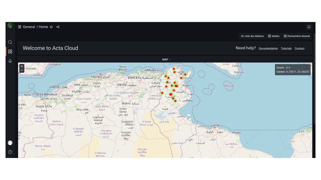
Map
×2.6 Date of implementation
If precise year is not known, indicate approximate date:
- more than 50 years ago (traditional)
2.7 Introduction of the Technology
Specify how the Technology was introduced:
- as part of a traditional system (> 50 years)
Comments (type of project, etc.):
Jessour is an ancient runoff water harvesting technique widely practiced in the arid highlands, which are dominated by outcroppings of calcareous formations and depositions of quaternary calcareous silt.
3. Classification of the SLM Technology
3.2 Current land use type(s) where the Technology is applied

Cropland
- Annual cropping
- Tree and shrub cropping
Annual cropping - Specify crops:
- cereals - other
- cereals - wheat (spring)
- cereals - barley
- vegetables - other
- legumes and pulses - peas
Tree and shrub cropping - Specify crops:
- dates
- figs
- tree nuts (brazil nuts, pistachio, walnuts, almonds, etc.)
- olive
Number of growing seasons per year:
- 1
Specify:
Longest growing period in days: 180Longest growing period from month to month: Oct - Mar
Comments:
Major land use problems (compiler’s opinion): Loss of surface water (runoff), problems of flooding, water erosion, soil degradation, drought
Future (final) land use (after implementation of SLM Technology): Cropland: Ct: Tree and shrub cropping
Livestock is grazing on crop residues
3.3 Has land use changed due to the implementation of the Technology?
Has land use changed due to the implementation of the Technology?
- Yes (Please fill out the questions below with regard to the land use before implementation of the Technology)
Land use mixed within the same land unit:
Yes
Specify mixed land use (crops/ grazing/ trees):
- Agro-pastoralism (incl. integrated crop-livestock)
Cropland
- Tree and shrub cropping

Grazing land
3.4 Water supply
Water supply for the land on which the Technology is applied:
- rainfed
Comments:
Water supply: rainfed, mixed rainfed - irrigated
3.5 SLM group to which the Technology belongs
- windbreak/ shelterbelt
- water harvesting
- irrigation management (incl. water supply, drainage)
3.6 SLM measures comprising the Technology

structural measures
- S2: Bunds, banks
Comments:
Main measures: structural measures
3.7 Main types of land degradation addressed by the Technology

soil erosion by water
- Wt: loss of topsoil/ surface erosion
- Wg: gully erosion/ gullying
Comments:
Main type of degradation addressed: Wt: loss of topsoil / surface erosion
Secondary types of degradation addressed: Wg: gully erosion / gullying
Main causes of degradation: crop management (annual, perennial, tree/shrub), change of seasonal rainfall, Heavy / extreme rainfall (intensity/amounts), poverty / wealth
Secondary causes of degradation: soil management, overgrazing, land tenure
3.8 Prevention, reduction, or restoration of land degradation
Specify the goal of the Technology with regard to land degradation:
- prevent land degradation
- reduce land degradation
Comments:
Main goals: mitigation / reduction of land degradation
Secondary goals: prevention of land degradation
4. Technical specifications, implementation activities, inputs, and costs
4.1 Technical drawing of the Technology
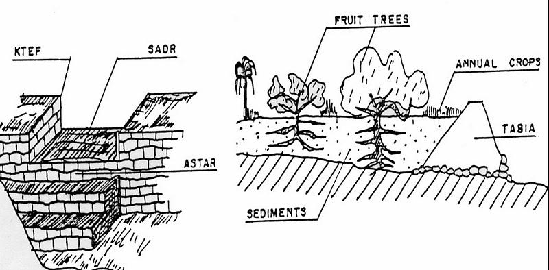
Technical specifications (related to technical drawing):
Left: Cross-section of dyke (locally called tabia) and terrace (cropping area).
The Jessour ensure the collection of both runoff water and sediments allowing creating very deep ‘artificial’ soils (terrace) which form a very good reservoir for water and nutrients to be used by fruit trees and annual crops.
Right: The spillway allows the overflow to the other Jessour downstream. It also represents the symbol of water sharing equity between different farmers in the same watershed. (Drawing adapted from El Amami (1984))
Location: Mountainous zone near Beni Khedache. Medenine
Date: 1984
Technical knowledge required for field staff / advisors: moderate
Technical knowledge required for land users: moderate
Main technical functions: increase of infiltration, sediment retention / trapping, sediment harvesting, harvesting of runoff water / water trapping
Secondary technical functions: control of concentrated runoff: retain / trap, improvement of ground cover, increase / maintain water stored in soil, increase of groundwater level / recharge of groundwater, increase of biomass (quantity)
Spillway
Height of bunds/banks/others (m): 2-5
Width of bunds/banks/others (m): 0.4-0.6
Length of bunds/banks/others (m): 2-6
Dam/ pan/ pond
Vertical interval between structures (m): 2-3
Spacing between structures (m): 30-70
Height of bunds/banks/others (m): 2-6
Width of bunds/banks/others (m): 1-5
Length of bunds/banks/others (m): 10-40
Construction material (earth): Main dyke
Construction material (stone): Spillway and in some cases the dyke (external coating)
Construction material (concrete): Occasionally for consolidation of the spillway.
Lateral gradient along the structure: <1%
Specification of dams/ pans/ ponds: Capacity 300-1000m3
Catchment area: 1-10ham2
Beneficial area: 0.01-1ham2
For water harvesting: the ratio between the area where the harvested water is applied and the total area from which water is collected is: 1:5
Author:
Ouessar M., IRA, Medenine, Tunisia
4.2 General information regarding the calculation of inputs and costs
other/ national currency (specify):
TD
If relevant, indicate exchange rate from USD to local currency (e.g. 1 USD = 79.9 Brazilian Real): 1 USD =:
1.3
Indicate average wage cost of hired labour per day:
10.00
4.3 Establishment activities
| Activity | Timing (season) | |
|---|---|---|
| 1. | Dyke construction | |
| 2. | Plantations | |
| 3. | Spillway construction |
4.4 Costs and inputs needed for establishment
| Specify input | Unit | Quantity | Costs per Unit | Total costs per input | % of costs borne by land users | |
|---|---|---|---|---|---|---|
| Labour | Labour | ha | 1.0 | 1200.0 | 1200.0 | 100.0 |
| Plant material | ha | 1.0 | 800.0 | 800.0 | 100.0 | |
| Construction material | ha | 1.0 | 1000.0 | 1000.0 | 100.0 | |
| Total costs for establishment of the Technology | 3000.0 | |||||
| Total costs for establishment of the Technology in USD | 2307.69 | |||||
Comments:
Duration of establishment phase: 6 month(s)
4.5 Maintenance/ recurrent activities
| Activity | Timing/ frequency | |
|---|---|---|
| 1. | Crop and trees maintenance | Annually |
| 2. | Dyke and spillway maintenance | |
| 3. | Repairs | |
| 4. | Tillage (against soil sealing) | |
| 5. | Tillage (against soil sealing) | Annually and after rainy events |
4.6 Costs and inputs needed for maintenance/ recurrent activities (per year)
| Specify input | Unit | Quantity | Costs per Unit | Total costs per input | % of costs borne by land users | |
|---|---|---|---|---|---|---|
| Labour | Labour | ha | 1.0 | 400.0 | 400.0 | 100.0 |
| Plant material | ha | 1.0 | 200.0 | 200.0 | 100.0 | |
| Construction material | ha | 1.0 | 300.0 | 300.0 | 100.0 | |
| Total costs for maintenance of the Technology | 900.0 | |||||
| Total costs for maintenance of the Technology in USD | 692.31 | |||||
Comments:
Machinery/ tools: Tractor, animals and manual works.
The technology establishment and maintenance costs met by the land users are 100% if executed on a private basis, but it can range from 10 to 50% when the site is subject to a publicly-funded programme.
4.7 Most important factors affecting the costs
Describe the most determinate factors affecting the costs:
Found in inaccessible and even remote areas, labour is the most determining factors affecting the costs of this system.
5. Natural and human environment
5.1 Climate
Annual rainfall
- < 250 mm
- 251-500 mm
- 501-750 mm
- 751-1,000 mm
- 1,001-1,500 mm
- 1,501-2,000 mm
- 2,001-3,000 mm
- 3,001-4,000 mm
- > 4,000 mm
Agro-climatic zone
- arid
Thermal climate class: subtropics
5.2 Topography
Slopes on average:
- flat (0-2%)
- gentle (3-5%)
- moderate (6-10%)
- rolling (11-15%)
- hilly (16-30%)
- steep (31-60%)
- very steep (>60%)
Landforms:
- plateau/plains
- ridges
- mountain slopes
- hill slopes
- footslopes
- valley floors
Altitudinal zone:
- 0-100 m a.s.l.
- 101-500 m a.s.l.
- 501-1,000 m a.s.l.
- 1,001-1,500 m a.s.l.
- 1,501-2,000 m a.s.l.
- 2,001-2,500 m a.s.l.
- 2,501-3,000 m a.s.l.
- 3,001-4,000 m a.s.l.
- > 4,000 m a.s.l.
Comments and further specifications on topography:
Altitudinal zone: 101-500 m a.s.l. (This is the most appropriate location)
Landforms: Mountain slopes (This is the most appropriate location)
5.3 Soils
Soil depth on average:
- very shallow (0-20 cm)
- shallow (21-50 cm)
- moderately deep (51-80 cm)
- deep (81-120 cm)
- very deep (> 120 cm)
Soil texture (topsoil):
- coarse/ light (sandy)
- medium (loamy, silty)
Topsoil organic matter:
- low (<1%)
If available, attach full soil description or specify the available information, e.g. soil type, soil PH/ acidity, Cation Exchange Capacity, nitrogen, salinity etc.
Soil depth: Very shallow-shallow. Very deep in particular case of loess deposits.
Soil fertility is: Very low
Soil drainage/infiltration is: Medium
Soil water storage: Medium
5.4 Water availability and quality
Ground water table:
5-50 m
Availability of surface water:
medium
Water quality (untreated):
poor drinking water (treatment required)
Comments and further specifications on water quality and quantity:
Water quality untreated: Poor drinking water (treatement required) (ground water better than surface water (cisterns))
5.5 Biodiversity
Species diversity:
- medium
5.6 Characteristics of land users applying the Technology
Market orientation of production system:
- subsistence (self-supply)
- mixed (subsistence/ commercial)
Off-farm income:
- > 50% of all income
Relative level of wealth:
- poor
- average
Individuals or groups:
- individual/ household
Level of mechanization:
- manual work
- animal traction
Gender:
- men
Indicate other relevant characteristics of the land users:
Land users applying the Technology are mainly common / average land users
Difference in the involvement of women and men: Historically, the hard work is done by men.
Population density: 10-50 persons/km2
Annual population growth: < 0.5%
10% of the land users are rich and own 20% of the land.
80% of the land users are average wealthy and own 75% of the land.
10% of the land users are poor and own 5% of the land.
Off-farm income specification: The technique is very ancient and, therefore, ALL the farmers apply this technology. The only difference is the number of the owned units.
Off-farm incomes come from migration, construction works, commerce, tourism sector, administration or informal activities.
Level of mechanization: Manual work and animal traction (Especially in remote areas with difficult access)
5.7 Average area of land used by land users applying the Technology
- < 0.5 ha
- 0.5-1 ha
- 1-2 ha
- 2-5 ha
- 5-15 ha
- 15-50 ha
- 50-100 ha
- 100-500 ha
- 500-1,000 ha
- 1,000-10,000 ha
- > 10,000 ha
Is this considered small-, medium- or large-scale (referring to local context)?
- small-scale
5.8 Land ownership, land use rights, and water use rights
Land ownership:
- individual, not titled
Land use rights:
- individual
Water use rights:
- individual
Comments:
The communal rule applies in this region: the farmer owns the terrace (the cropping area) and its impluvium from which the runoff is harvested.
5.9 Access to services and infrastructure
health:
- poor
- moderate
- good
education:
- poor
- moderate
- good
technical assistance:
- poor
- moderate
- good
employment (e.g. off-farm):
- poor
- moderate
- good
markets:
- poor
- moderate
- good
energy:
- poor
- moderate
- good
roads and transport:
- poor
- moderate
- good
drinking water and sanitation:
- poor
- moderate
- good
financial services:
- poor
- moderate
- good
6. Impacts and concluding statements
6.1 On-site impacts the Technology has shown
Socio-economic impacts
Production
crop production
risk of production failure
product diversity
production area
Comments/ specify:
Reduced grazing lands
Income and costs
farm income
diversity of income sources
Socio-cultural impacts
food security/ self-sufficiency
SLM/ land degradation knowledge
conflict mitigation
situation of socially and economically disadvantaged groups
Ecological impacts
Water cycle/ runoff
harvesting/ collection of water
surface runoff
groundwater table/ aquifer
Soil
soil loss
6.2 Off-site impacts the Technology has shown
water availability
reliable and stable stream flows in dry season
downstream flooding
downstream siltation
damage on public/ private infrastructure
Runoff
Comments/ specify:
Reduced available runoff for downstream users
6.3 Exposure and sensitivity of the Technology to gradual climate change and climate-related extremes/ disasters (as perceived by land users)
Gradual climate change
Gradual climate change
| Season | increase or decrease | How does the Technology cope with it? | |
|---|---|---|---|
| annual temperature | increase | well |
Climate-related extremes (disasters)
Meteorological disasters
| How does the Technology cope with it? | |
|---|---|
| local rainstorm | well |
| local windstorm | well |
Climatological disasters
| How does the Technology cope with it? | |
|---|---|
| drought | well |
Hydrological disasters
| How does the Technology cope with it? | |
|---|---|
| general (river) flood | not well |
Other climate-related consequences
Other climate-related consequences
| How does the Technology cope with it? | |
|---|---|
| reduced growing period | well |
6.4 Cost-benefit analysis
How do the benefits compare with the establishment costs (from land users’ perspective)?
Short-term returns:
very negative
Long-term returns:
very positive
How do the benefits compare with the maintenance/ recurrent costs (from land users' perspective)?
Short-term returns:
neutral/ balanced
Long-term returns:
positive
6.5 Adoption of the Technology
Of all those who have adopted the Technology, how many did so spontaneously, i.e. without receiving any material incentives/ payments?
- 91-100%
Comments:
10% of land user families have adopted the Technology with external material support
90% of land user families have adopted the Technology without any external material support
Comments on spontaneous adoption: This technique is very ancient and it is therefore already fully adopted/used in the region.
There is a moderate trend towards spontaneous adoption of the Technology
6.7 Strengths/ advantages/ opportunities of the Technology
| Strengths/ advantages/ opportunities in the land user’s view |
|---|
|
Well known technique by the local population How can they be sustained / enhanced? training of new generations |
| Strengths/ advantages/ opportunities in the compiler’s or other key resource person’s view |
|---|
|
This technique allowed a expansion of cropping lands in the mountain area How can they be sustained / enhanced? encourage maintenance of existing structure |
|
Allows crop production in very dry environments (with less than 200 mm of rainfall) How can they be sustained / enhanced? encourage maintenance of existing structure |
|
Collects and accumulates water, soil and nutrients behind the tabia and makes it available to crops How can they be sustained / enhanced? encourage maintenance of existing structure |
|
Reduced damage by flooding How can they be sustained / enhanced? encourage maintenance of existing structure |
|
Well adapted technology for the ecological environment How can they be sustained / enhanced? ensure maintenance works |
6.8 Weaknesses/ disadvantages/ risks of the Technology and ways of overcoming them
| Weaknesses/ disadvantages/ risks in the land user’s view | How can they be overcome? |
|---|---|
| Productivity of the land is very low | Development of alternative income generation activities. |
| Land ownership fragmentation | New land access |
| Weaknesses/ disadvantages/ risks in the compiler’s or other key resource person’s view | How can they be overcome? |
|---|---|
| Risks related to the climatic changes | It needs to be combined with supplemental irrigation |
| Risk of local know how disappearence | Trainig of new generations |
| Land ownership fragmentation | Agrarian reform |
7. References and links
7.1 Methods/ sources of information
7.2 References to available publications
Title, author, year, ISBN:
El Amami, S. 1984. Les aménagements hydrauliques traditionnels en Tunisie. Centre de Recherche en Génie Rural (CRGR), Tunis, Tunisia. 69 pp.
Available from where? Costs?
ENGREF - Tunis
Title, author, year, ISBN:
Ennabli, N. 1993. Les aménagements hydrauliques et hydro-agricoles en Tunisie. Imprimerie Officielle de la République Tunisienne, Tunis, 255 pp.
Available from where? Costs?
INAT - Tunis
Title, author, year, ISBN:
Ben Mechlia, N., Ouessar, M. 2004. Water harvesting systems in Tunisia. In: Oweis, T., Hachum, A., Bruggeman, A. (eds). Indigenous water harvesting in West Asia and North Africa, , ICARDA, Aleppo, Syria, pp: 21-41.
Available from where? Costs?
ICARDA
Title, author, year, ISBN:
Genin, D., Guillaume, H., Ouessar, M., Ouled Belgacem, A., Romagny, B., Sghaier, M., Taamallah, H. (eds) 2006. Entre la désertification et le développement : la Jeffara tunisienne. CERES, Tunis, 351 pp.
Available from where? Costs?
IRA; IRD
Title, author, year, ISBN:
Ouessar M. 2007. Hydrological impacts of rainwater harvesting in wadi Oum Zessar watershed (Southern Tunisia). Ph.D. thesis, Faculty of Bioscience Engineering, Ghent University, Ghent, Belgium, 154 pp.
Available from where? Costs?
IRA
Title, author, year, ISBN:
Sghaier, M., Mahdhi, N., De Graaff, J., Ouessar, M. 2002. Economic assessment of soil and water conservation works: case of the wadi Oum Zessar watershed in south-eastern Tunisia.TRMP paper n° 40, Wageningen University, The Netherlands, pp: 101-113.
Available from where? Costs?
IRA
Links and modules
Expand all Collapse allLinks
Territorial Natural Resource Management Observatory [Tunisia]
A territorial natural resources management observatory is a scientific, technical and institutional system set up in a given area to observe, monitor and improve knowledge.
- Compiler: Wafa Saidi
Integrated Territorial Planning and Development Project (PADIT) [Tunisia]
The PADIT approach comprises a cross-cutting participatory methodology to rural development, rallying various stakeholders around a project, within a location, to identify the main economic areas of the rural community concerned, and draw up a prioritized list of actions to strengthen and support development efforts in their location.
- Compiler: Wafa Saidi
Collecte des eaux pluviales dans des citernes [Tunisia]
Les citernes sont construites soit par l’état dans les zones enclavées où l’approvisionnement en eaux potables et difficile voire impossible par le réseau de la Société Nationale d’Exploitation et de Distribution des Eaux (SONEDE) soit par des particuliers pour collecter les eaux de pluies. Ces ouvrages sont destinés à l’abreuvement …
- Compiler: Donia Mühlematter
Conservation des eaux et des sols suivant la … [Tunisia]
Les « jessour » sont développés dans les zones montagneuses de Gabès, Mede-nine et Tataouine où l’altitude varie entre 400 et 600 m et une pluviométrie an-nuelle variant entre 100 et 150 mm. Dans cette zone, on compte aux alentours de 35 000 jisr qui reçoit chacun annuellement un supplément …
- Compiler: Donia Mühlematter
Dryland watershed management approach [Tunisia]
Integrated land and water management approach, including vegetative, management, and agronomic measure
- Compiler: Naceur Mahdi
Modules
No modules