Using water from a fishpond for the cultivation of dry season paddy rice [Lao People's Democratic Republic]
- Creation:
- Update:
- Compiler: jimmy luangphithack
- Editors: Bounthanom Bouahom, Pasalath Khounsy, anousit namsena, kang phanvongsa
- Reviewers: Oulaytham Lasasimma, Stephanie Jaquet, Nicole Harari
technologies_2923 - Lao People's Democratic Republic
View sections
Expand all Collapse all1. General information
1.2 Contact details of resource persons and institutions involved in the assessment and documentation of the Technology
Key resource person(s)
land user:
Moad Umnoi
030 9137108
Doup village, Ta-oy district, Salavan province
Lao People's Democratic Republic
Name of project which facilitated the documentation/ evaluation of the Technology (if relevant)
Scaling-up SLM practices by smallholder farmers (IFAD)Name of the institution(s) which facilitated the documentation/ evaluation of the Technology (if relevant)
National Agriculture and Forestry Research Institute (NAFRI) - Lao People's Democratic Republic1.3 Conditions regarding the use of data documented through WOCAT
When were the data compiled (in the field)?
11/07/2017
The compiler and key resource person(s) accept the conditions regarding the use of data documented through WOCAT:
Yes
1.4 Declaration on sustainability of the described Technology
Is the Technology described here problematic with regard to land degradation, so that it cannot be declared a sustainable land management technology?
No
2. Description of the SLM Technology
2.1 Short description of the Technology
Definition of the Technology:
Technique on the use of water from fishpond for dry season rice cultivation to increase yields
2.2 Detailed description of the Technology
Description:
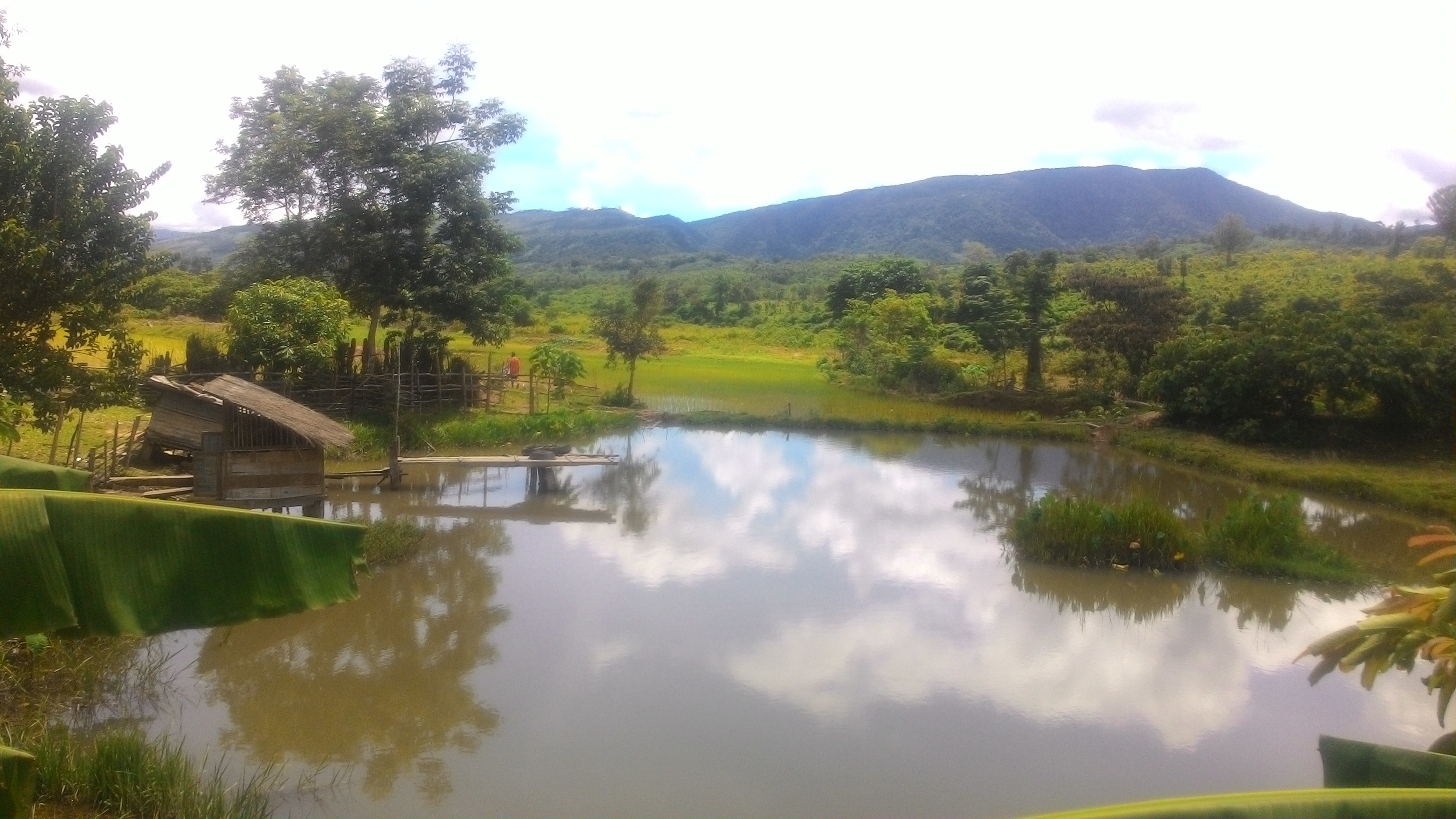
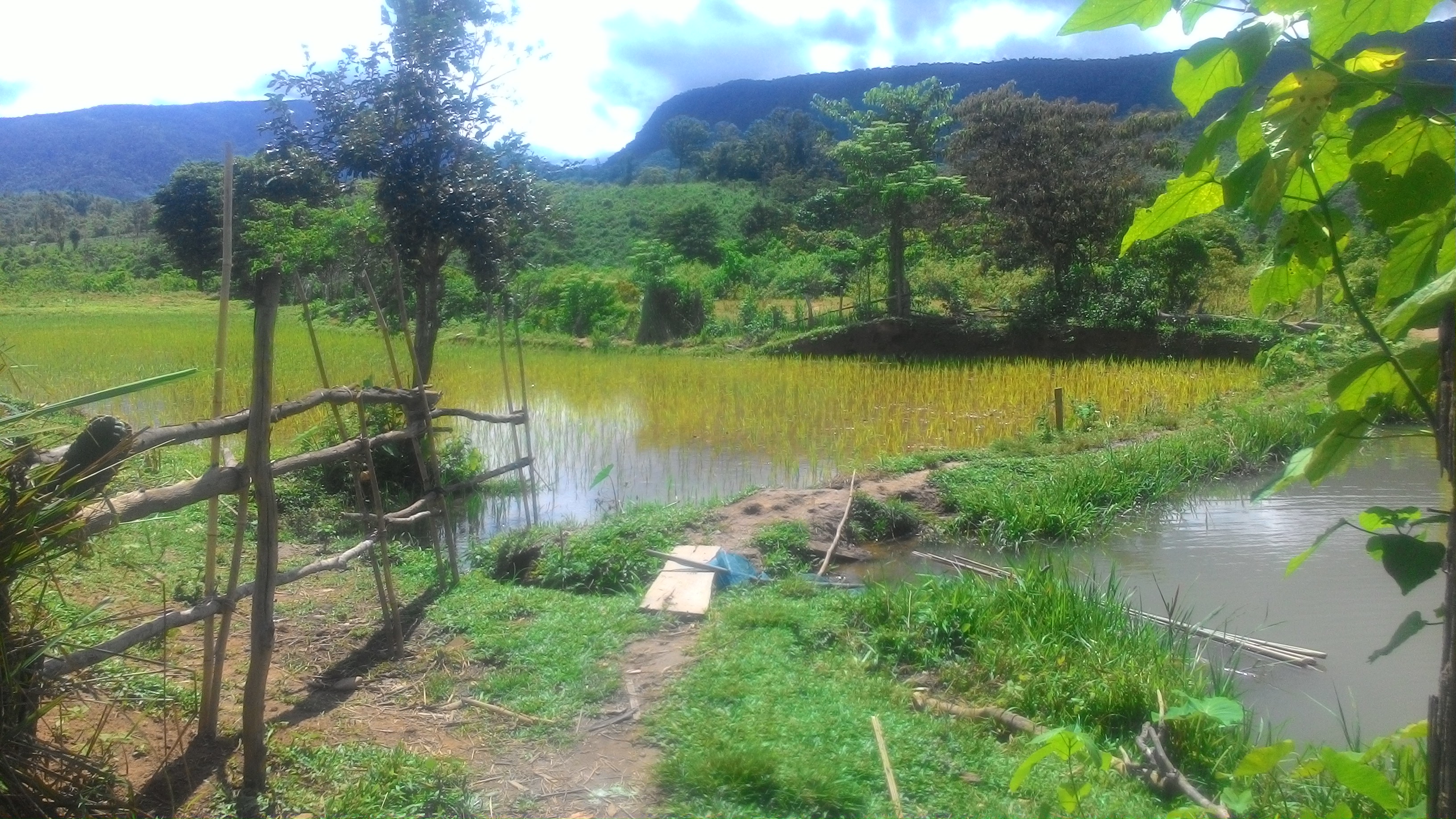
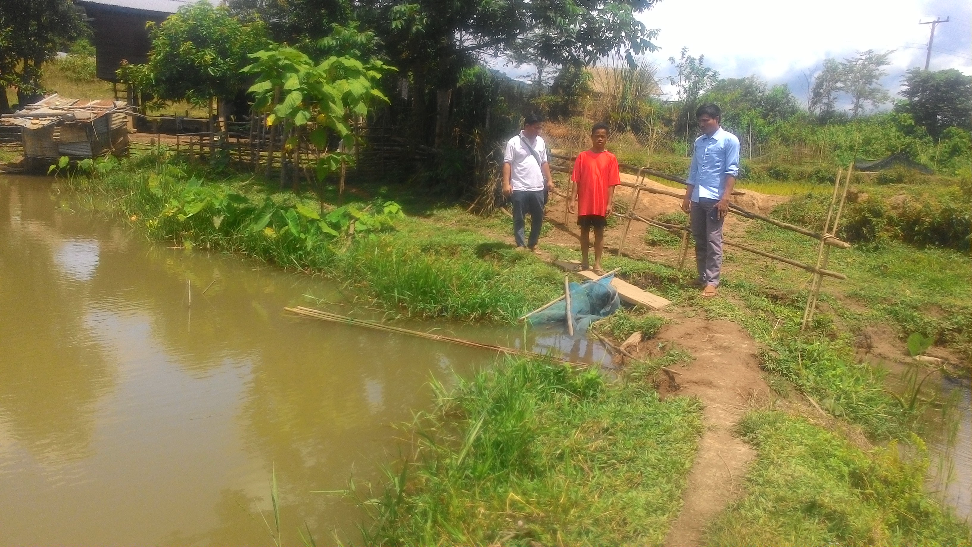
This technique involves the use of water from a fishpond for the cultivation of dry season paddy rice, and it was introduced in area of 0.5 ha of irrigated paddy fields in 2010. Dry season rice cultivation is normally prevented by an inadequate water supply. Farmers can usually only practice rain fed rice cultivation. However, in 2012 one land user had an idea so as to maximize the use of his land. He hired a backhoe in order to excavate a pond which he could then use for fish breeding. The pond’s total volume is 1,700 m2 and it measures 50 meters x 30 meters, with a depth of 1.5 meters. A canal had been dug to fill the pond with water from a nearby stream. The pond is utilized for fish breeding, and the water is also diverted for the cultivation of rice in both the dry and wet seasons. This is done by utilizing small 40 cm wide irrigation canals which were established to supply water to the rice paddies. This technique therefore not only assists agricultural practices but also enables aquaculture and thus has provided households with increased food security. Furthermore the rice paddies have become more productive throughout the plantation periods. The fishpond also manages to control erosion as it retains the run-off water from the surrounding forest areas. This run off is held by the pond before it reaches the rice fields. Therefore, the technique helps to sustain agricultural activities on the land and reduce localized drought. However, supplying water to areas that are at a higher elevation than the pond remains difficult; farmers are unable provide sufficient amounts of water without the use of a pump. After adopting this technique land users have been very satisfied with the outputs as they can cultivate rice throughout the year, so in both the dry and the rainy seasons, and as a result have produced higher yields of rice. They have also been able to raise fish which has provided meat for household consumption. This means that the families applying the technique are currently better off. Additionally, the soil has become moister and this has prevented the development of clods as had happened in the past. The fishpond is 50 meters long, 30 meters wide and has a depth of 1.5 meters. The water gate, which measures 40cm x 40cm has been constructed with planks. In the dry season particularly when there is an inadequate amount of water in the rice field, the farmer will open this gate so as to divert water from the pond to the rice fields. They are able to use half of the pond’s volume of water at one time, and then it will gradually have to be filled up again with water that runs through a canal from the stream. It takes a few days to refill the pond and then the farmers are once again able to irrigate their paddies. The pond was established right next the rice paddies which can be fed through a 40 cm wide canal that is blocked by a wooden gate when not in use. Additionally a 5 HP, diesel water pump is used to pump water uphill from the fishpond to another 0.5ha paddy field. This is necessary because the paddy field, on a slope of 3-5% is located at a higher elevation - which is a characteristic feature of rice paddies. The species of fish fingerlings in the pond include tilapia, common carp and grass carp. As the fish are maturing the land users mostly feed them with rice bran because it is readily available. A plastic net is used as a filter in front of either the pump inlet when irrigating the paddy field upstream or the gate when water is being diverted to the paddy field downstream so as to avoid the loss of fish. The pond has a storage capacity is 2,000 m3 and it is replenished from a natural source by a canal that was recently constructed by the land users. Strengths: (1) Water from the fishpond can be used for rice cultivation in both the dry and rainy seasons, thereby enabling agricultural activities without the provision of water from an irrigation system. (2) It enables fish breeding and therefore land users can propagate various fish fingerlings. Weaknesses: (1) The fishpond is located at a lower elevation than some of the paddy fields and thus only a limited area can be supplied through gravity fed irrigation ; (3) A diesel water pump is needed to supply water to some of the fields to enable the cultivation of rice.
2.3 Photos of the Technology
Media Gallery
2.5 Country/ region/ locations where the Technology has been applied and which are covered by this assessment
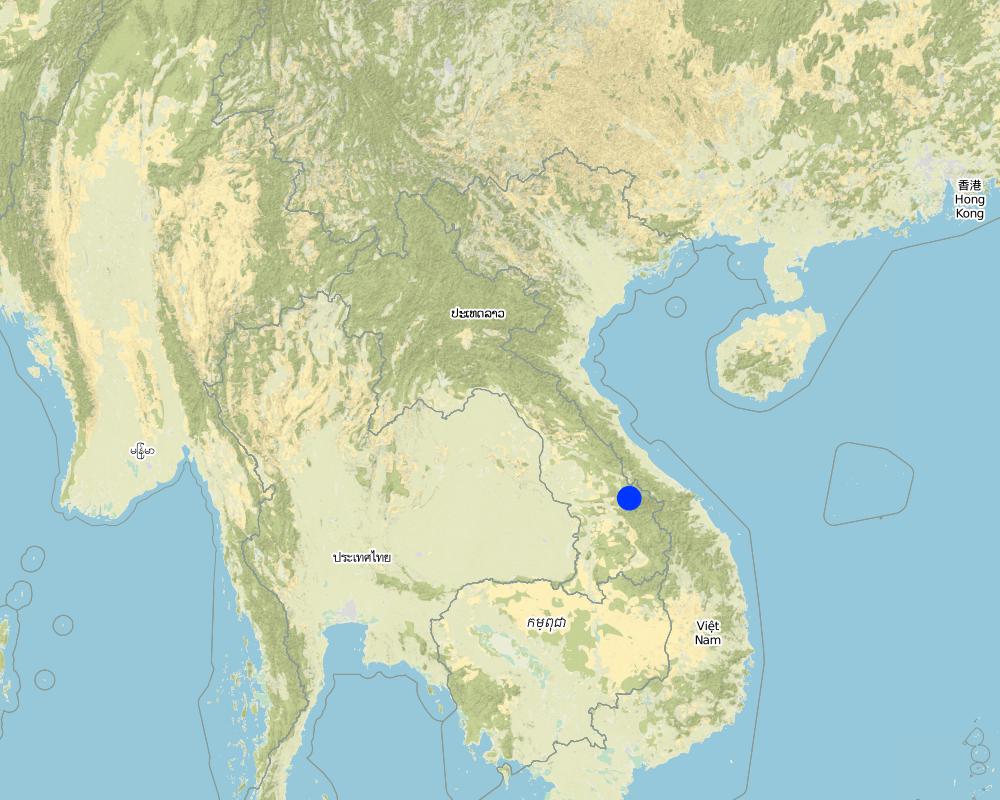
Country:
Lao People's Democratic Republic
Region/ State/ Province:
TaOuy District, Salavan Province
Further specification of location:
Doup village
Map
×2.6 Date of implementation
Indicate year of implementation:
2012
If precise year is not known, indicate approximate date:
- less than 10 years ago (recently)
2.7 Introduction of the Technology
Specify how the Technology was introduced:
- through land users' innovation
3. Classification of the SLM Technology
3.1 Main purpose(s) of the Technology
- improve production
- reduce, prevent, restore land degradation
- reduce risk of disasters
3.2 Current land use type(s) where the Technology is applied

Cropland
- Annual cropping
Main crops (cash and food crops):
Paddy rice

Waterways, waterbodies, wetlands
- Ponds, dams
Main products/ services:
Produce fish and using water in the pond for paddy rice cultivation
3.3 Further information about land use
Water supply for the land on which the Technology is applied:
- mixed rainfed-irrigated
Number of growing seasons per year:
- 2
Specify:
Paddy rice
Livestock density (if relevant):
1000 fish/season
3.4 SLM group to which the Technology belongs
- water harvesting
- irrigation management (incl. water supply, drainage)
- beekeeping, aquaculture, poultry, rabbit farming, silkworm farming, etc.
3.5 Spread of the Technology
Specify the spread of the Technology:
- applied at specific points/ concentrated on a small area
3.6 SLM measures comprising the Technology

structural measures
- S5: Dams, pans, ponds
- S7: Water harvesting/ supply/ irrigation equipment

management measures
- M1: Change of land use type
3.7 Main types of land degradation addressed by the Technology

soil erosion by water
- Wg: gully erosion/ gullying
3.8 Prevention, reduction, or restoration of land degradation
Specify the goal of the Technology with regard to land degradation:
- prevent land degradation
- reduce land degradation
4. Technical specifications, implementation activities, inputs, and costs
4.1 Technical drawing of the Technology
Author:
Phonesyli Phanvongsa
Date:
11/07/2017
4.2 Technical specifications/ explanations of technical drawing
The fish pond is 50 meters in length, 20 meters in width and has a depth 1.5 meters. Levees with a thickness of 40 cm run around the edge of the pond and separate it from the rice fields. A wooden outlet door measuring 40 x 40 cm has been installed in one corner of the pond. The rice paddies in either a downhill or uphill direction lie on a gentle slope of about 3-5%. The fish species being bred in the pond include Tilapia, Silver carp and Grass carp. The storage capacity of the pond is 2000 m3. A pump and 10 meter tubes are used for uphill irrigation.
4.3 General information regarding the calculation of inputs and costs
Specify how costs and inputs were calculated:
- per Technology unit
Specify unit:
Fish pond
Specify volume, length, etc. (if relevant):
length 50m, width 20m, volume 2000m3
other/ national currency (specify):
kip
Indicate exchange rate from USD to local currency (if relevant): 1 USD =:
8000.0
Indicate average wage cost of hired labour per day:
50000 kip
4.4 Establishment activities
| Activity | Type of measure | Timing | |
|---|---|---|---|
| 1. | Dig the pond using an excavator | Structural | In April |
| 2. | Build levees (embankments) around the edge of the pond | Structural | In April |
| 3. | Dig a canal from the stream to the pond | Structural | In April |
| 4. | Construct a wooden gate | Structural | In April |
| 5. | Fill the pond with water | Other measures | May |
| 6. | Install a pump and tubes in order to irrigate fields at a higher elevation | Management | May |
4.5 Costs and inputs needed for establishment
| Specify input | Unit | Quantity | Costs per Unit | Total costs per input | % of costs borne by land users | |
|---|---|---|---|---|---|---|
| Labour | Labor for build an embankment (levee) and construct a wooden gate | person | 6.0 | 50000.0 | 300000.0 | 100.0 |
| Labour | Labor for dig a canal from stream to pond | person | 5.0 | 50000.0 | 250000.0 | 100.0 |
| Labour | Labour for drained water to the paddy field | person | 2.0 | 50000.0 | 100000.0 | 100.0 |
| Equipment | Shovel | piece | 2.0 | 25000.0 | 50000.0 | 100.0 |
| Equipment | Excavator | Day | 2.0 | 500000.0 | 1000000.0 | 100.0 |
| Equipment | Hoe | piece | 3.0 | 40000.0 | 120000.0 | 100.0 |
| Equipment | Pump | Machine | 1.0 | 1200000.0 | 1200000.0 | 100.0 |
| Equipment | Tube | Meter | 10.0 | 8000.0 | 80000.0 | 100.0 |
| Construction material | Wood | piece | 2.0 | 15000.0 | 30000.0 | 100.0 |
| Other | Fish fingerling | head | 1000.0 | 200.0 | 200000.0 | 100.0 |
| Total costs for establishment of the Technology | 3330000.0 | |||||
4.6 Maintenance/ recurrent activities
| Activity | Type of measure | Timing/ frequency | |
|---|---|---|---|
| 1. | Repair levees | Structural | After harvest in June and November |
| 2. | Repair the outlet door | Structural | Time a year |
| 3. | Divert water to the paddy fields | Management | Before planting rice |
| 4. | Pump water to the paddy fields at a higher elevation | Management | Before planting rice |
| 5. | Feed the fish | Management | time /day |
4.7 Costs and inputs needed for maintenance/ recurrent activities (per year)
| Specify input | Unit | Quantity | Costs per Unit | Total costs per input | % of costs borne by land users | |
|---|---|---|---|---|---|---|
| Labour | Labor for repair levees and outlet door | Person | 4.0 | 50000.0 | 200000.0 | 100.0 |
| Labour | Labor for drained water to the paddy field | Person | 1.0 | 50000.0 | 50000.0 | 100.0 |
| Labour | Labor for pumping water to uphill paddy | Person | 1.0 | 50000.0 | 50000.0 | 100.0 |
| Labour | Labor for fish feeding | Person | 1.0 | 50000.0 | 50000.0 | 100.0 |
| Equipment | Hoe | Piece | 2.0 | 40000.0 | 80000.0 | 100.0 |
| Equipment | Shovel | Piece | 2.0 | 25000.0 | 50000.0 | 100.0 |
| Construction material | Wood | 2.0 | 15000.0 | 30000.0 | 100.0 | |
| Total costs for maintenance of the Technology | 510000.0 | |||||
4.8 Most important factors affecting the costs
Describe the most determinate factors affecting the costs:
The hiring excavator and labor is important effect to the cost of implementation.
5. Natural and human environment
5.1 Climate
Annual rainfall
- < 250 mm
- 251-500 mm
- 501-750 mm
- 751-1,000 mm
- 1,001-1,500 mm
- 1,501-2,000 mm
- 2,001-3,000 mm
- 3,001-4,000 mm
- > 4,000 mm
Specify average annual rainfall (if known), in mm:
700.00
Specifications/ comments on rainfall:
From January - March is less rain, in April is more rain and highest is from July - September then decrease in October till December
Indicate the name of the reference meteorological station considered:
Doup village meteorological Office
Agro-climatic zone
- sub-humid
Warmest is in May with average temperature 27c
Coldest in January with average temperature is 20c
5.2 Topography
Slopes on average:
- flat (0-2%)
- gentle (3-5%)
- moderate (6-10%)
- rolling (11-15%)
- hilly (16-30%)
- steep (31-60%)
- very steep (>60%)
Landforms:
- plateau/plains
- ridges
- mountain slopes
- hill slopes
- footslopes
- valley floors
Altitudinal zone:
- 0-100 m a.s.l.
- 101-500 m a.s.l.
- 501-1,000 m a.s.l.
- 1,001-1,500 m a.s.l.
- 1,501-2,000 m a.s.l.
- 2,001-2,500 m a.s.l.
- 2,501-3,000 m a.s.l.
- 3,001-4,000 m a.s.l.
- > 4,000 m a.s.l.
Indicate if the Technology is specifically applied in:
- not relevant
5.3 Soils
Soil depth on average:
- very shallow (0-20 cm)
- shallow (21-50 cm)
- moderately deep (51-80 cm)
- deep (81-120 cm)
- very deep (> 120 cm)
Soil texture (topsoil):
- medium (loamy, silty)
Soil texture (> 20 cm below surface):
- medium (loamy, silty)
Topsoil organic matter:
- medium (1-3%)
5.4 Water availability and quality
Ground water table:
< 5 m
Availability of surface water:
medium
Water quality (untreated):
good drinking water
Is water salinity a problem?
No
Is flooding of the area occurring?
Yes
Regularity:
episodically
5.5 Biodiversity
Species diversity:
- medium
Habitat diversity:
- medium
5.6 Characteristics of land users applying the Technology
Sedentary or nomadic:
- Sedentary
Market orientation of production system:
- subsistence (self-supply)
Off-farm income:
- less than 10% of all income
Relative level of wealth:
- average
Individuals or groups:
- individual/ household
Level of mechanization:
- manual work
Gender:
- women
- men
Age of land users:
- youth
- middle-aged
5.7 Average area of land owned or leased by land users applying the Technology
- < 0.5 ha
- 0.5-1 ha
- 1-2 ha
- 2-5 ha
- 5-15 ha
- 15-50 ha
- 50-100 ha
- 100-500 ha
- 500-1,000 ha
- 1,000-10,000 ha
- > 10,000 ha
Is this considered small-, medium- or large-scale (referring to local context)?
- small-scale
5.8 Land ownership, land use rights, and water use rights
Land ownership:
- individual, not titled
Land use rights:
- individual
Water use rights:
- individual
5.9 Access to services and infrastructure
health:
- poor
- moderate
- good
education:
- poor
- moderate
- good
technical assistance:
- poor
- moderate
- good
employment (e.g. off-farm):
- poor
- moderate
- good
markets:
- poor
- moderate
- good
energy:
- poor
- moderate
- good
roads and transport:
- poor
- moderate
- good
drinking water and sanitation:
- poor
- moderate
- good
financial services:
- poor
- moderate
- good
6. Impacts and concluding statements
6.1 On-site impacts the Technology has shown
Socio-economic impacts
Production
crop production
Quantity before SLM:
Produce rice only 1 season a year with 0.6 ton/year
Quantity after SLM:
Able to produce 2 seasons of paddy rice with average yield 1 ton/year
Comments/ specify:
An increase in yield because there is enough water to allow for two seasons of rice cultivation.
risk of production failure
Comments/ specify:
The availability of the pond’s water ensures that rice paddies can also be cultivated in the dry season.
Income and costs
expenses on agricultural inputs
Comments/ specify:
The pond enables the raising of fish and the water quantity and quality allows for the irrigation of the paddy fields, especially in the dry season.
farm income
Comments/ specify:
There is an increase in yield as land users are able to cultivate rice during two seasons and there is additional income from the sale of fish.
Socio-cultural impacts
food security/ self-sufficiency
Comments/ specify:
Previously before the pond’s construction, the land users were able to cultivate rice in one season which provided enough for a family’s consumption for 6-8 months of the year. After this technique was introduced, it allowed the farmers to expand the production area and also produce rice in the dry season. In this way they were able to produce a sufficient amount of rice to feed their families throughout the whole year.
conflict mitigation
Comments/ specify:
There is a sufficient amount of water in the pond for the cultivation of rice paddies which has reduced the irrigation needs in the village. The pond is filled by the canal that farmers constructed to divert water from the stream. Furthermore it is also possible for their neighbors to use water from the canal.
Ecological impacts
Water cycle/ runoff
water quantity
Comments/ specify:
Rice paddy cultivation relies on rainfall and so now when the dry season approaches, the farmers can use water from the pond, which they are able to refill by diverting water from the stream via the canal (water harvesting in the pond).
Soil
soil moisture
Comments/ specify:
In dry season the soil dries out, leading to soil crusting. However nowadays they are able to utilise the water from the pond to improve the dryness of the soil whenever it is needed.
soil crusting/ sealing
Comments/ specify:
Farmers let the water out of the pond and into the fields when the soil dries out and there is the issue of soil crusting, thereby improving and preparing the area for cultivation.
Biodiversity: vegetation, animals
animal diversity
Comments/ specify:
Due to the presence of the pond there is a great diversity of aquatic animals such as shrimps, crabs, snails, fish, snakes and frogs.
Climate and disaster risk reduction
drought impacts
Comments/ specify:
Drought impacts have been decreased because the land users are able to utilize the water that has been harvested in the pond to cope with these impacts.
6.2 Off-site impacts the Technology has shown
water availability
Comments/ specify:
Less water available down streams because it is used for the pond
downstream siltation
Comments/ specify:
There is less siltation downstream due to the pond, as it traps sediments.
6.3 Exposure and sensitivity of the Technology to gradual climate change and climate-related extremes/ disasters (as perceived by land users)
Gradual climate change
Gradual climate change
| Season | Type of climatic change/ extreme | How does the Technology cope with it? | |
|---|---|---|---|
| annual temperature | decrease | well | |
| seasonal temperature | wet/ rainy season | increase | well |
| annual rainfall | increase | moderately | |
| seasonal rainfall | wet/ rainy season | increase | moderately |
| other gradual climate change | increase | well |
Climate-related extremes (disasters)
Meteorological disasters
| How does the Technology cope with it? | |
|---|---|
| local rainstorm | not well |
| local hailstorm | not well |
6.4 Cost-benefit analysis
How do the benefits compare with the establishment costs (from land users’ perspective)?
Short-term returns:
slightly positive
Long-term returns:
very positive
How do the benefits compare with the maintenance/ recurrent costs (from land users' perspective)?
Short-term returns:
positive
Long-term returns:
very positive
6.5 Adoption of the Technology
- single cases/ experimental
Of all those who have adopted the Technology, how many have did so spontaneously, i.e. without receiving any material incentives/ payments?
- 90-100%
6.6 Adaptation
Has the Technology been modified recently to adapt to changing conditions?
No
6.7 Strengths/ advantages/ opportunities of the Technology
| Strengths/ advantages/ opportunities in the land user’s view |
|---|
| By using the water from the pond the farmers are able to cultivate rice paddies in both the wet and dry seasons. |
| The added potential of propagating aquatic animals. |
| Strengths/ advantages/ opportunities in the compiler’s or other key resource person’s view |
|---|
| Ability to cultivate rice paddies without an irrigation system. |
6.8 Weaknesses/ disadvantages/ risks of the Technology and ways of overcoming them
| Weaknesses/ disadvantages/ risks in the land user’s view | How can they be overcome? |
|---|---|
| The pond is at a lower elevation than some of the areas under cultivation, and so to an extent the flow of water is limited | A pump must be used to fill the rice fields at a higher elevation with water. |
7. References and links
7.1 Methods/ sources of information
- field visits, field surveys
1 time field visit
- interviews with land users
1 person
Links and modules
Expand all Collapse allLinks
No links
Modules
No modules