Soil and Water Conservation Channels [Uganda]
- Creation:
- Update:
- Compiler: Philip Tibenderana
- Editor: Mirjam Nufer
- Reviewers: Alexandra Gavilano, Hanspeter Liniger, Nicole Harari
Emirongooti
technologies_711 - Uganda
View sections
Expand all Collapse all1. General information
1.2 Contact details of resource persons and institutions involved in the assessment and documentation of the Technology
Key resource person(s)
SLM specialist:
Name of project which facilitated the documentation/ evaluation of the Technology (if relevant)
Book project: where people and their land are safer - A Compendium of Good Practices in Disaster Risk Reduction (DRR) (where people and their land are safer)Name of the institution(s) which facilitated the documentation/ evaluation of the Technology (if relevant)
Tear Fund Switzerland (Tear Fund Switzerland) - Switzerland1.3 Conditions regarding the use of data documented through WOCAT
The compiler and key resource person(s) accept the conditions regarding the use of data documented through WOCAT:
Yes
1.4 Declaration on sustainability of the described Technology
Is the Technology described here problematic with regard to land degradation, so that it cannot be declared a sustainable land management technology?
No
Comments:
So far, where this technology has been applied, the water runoff has been reduced, water retention increased and soils trapped
1.5 Reference to Questionnaire(s) on SLM Approaches (documented using WOCAT)
Catchment Based Integrated Water Resources Management [Uganda]
Catchment based integrated water resources management is a process which promotes the coordinated development and management of water, land and related resources in order to maximise economic and social welfare in an equitable manner without compromising the sustainability of vital eco systems
- Compiler: Philip Tibenderana
2. Description of the SLM Technology
2.1 Short description of the Technology
Definition of the Technology:
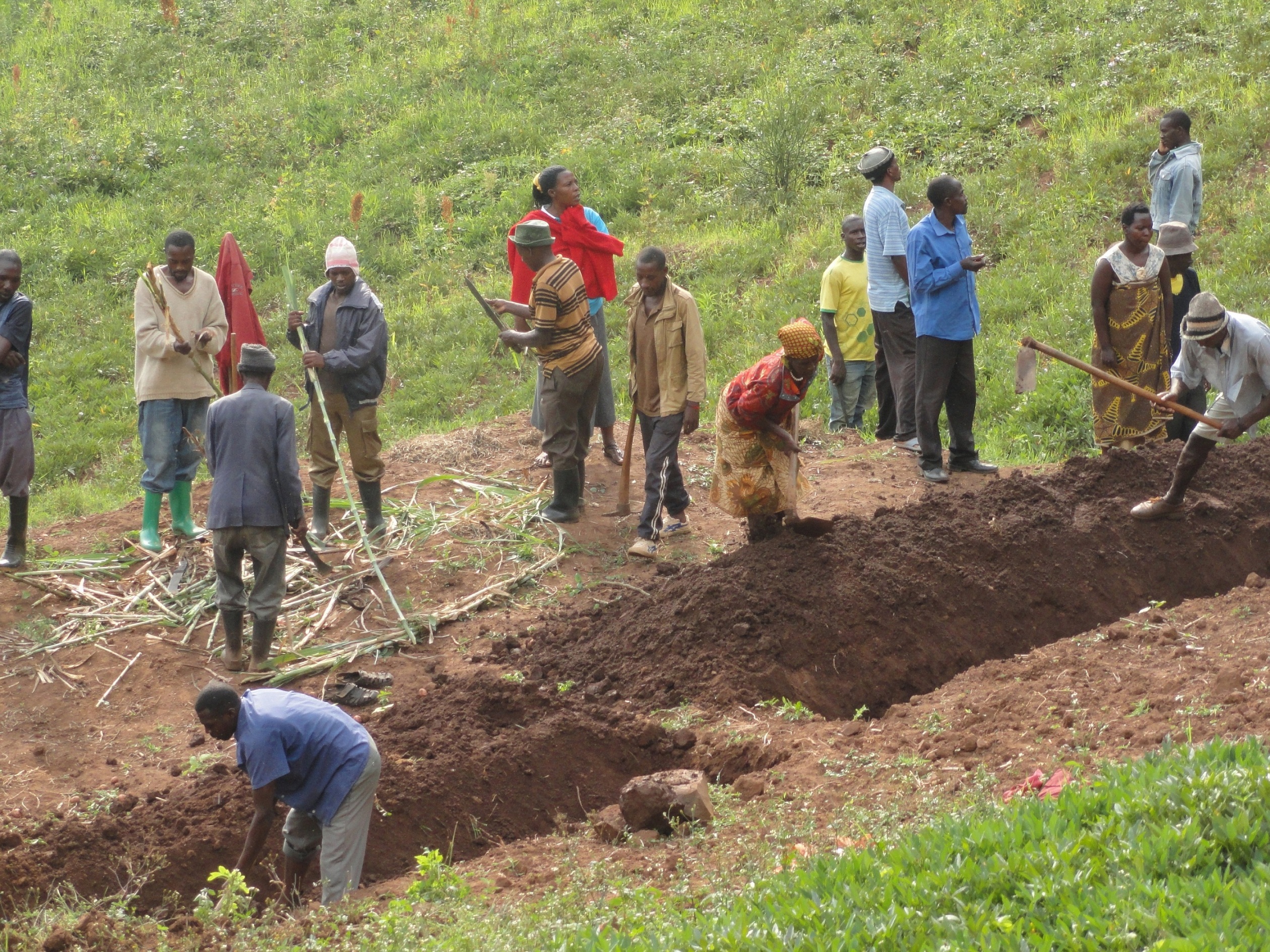
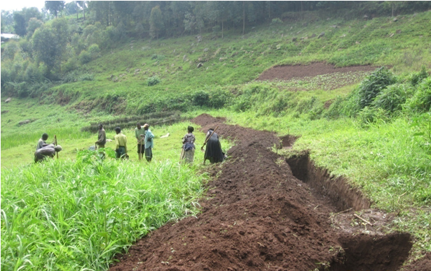
A soil and water conservation channel is an excavated trench along the contour with tie bands after an interval to trap water and soil which are being washed down the slopes by a downpour
2.2 Detailed description of the Technology
Description:
The technology is applied in already existing degraded farmlands, which are individually owned. An average farm size is less than half an acre.
A typical soil and water conservation channel is a trench 1m wide, 1m deep and with tie bands (1m wide to avoid flow of water along the trench) at intervals of 10m along the contour. The excavated soil is used piled up into an earth bund next to the trench at lower side and stabilized by planting hedge rows of "Starria grass" to avoid erosion.
This technology reduces the speed of water running down the slope during a downpour and traps the water and soil that is being washed thereby reducing soil erosion and increasing water retention.
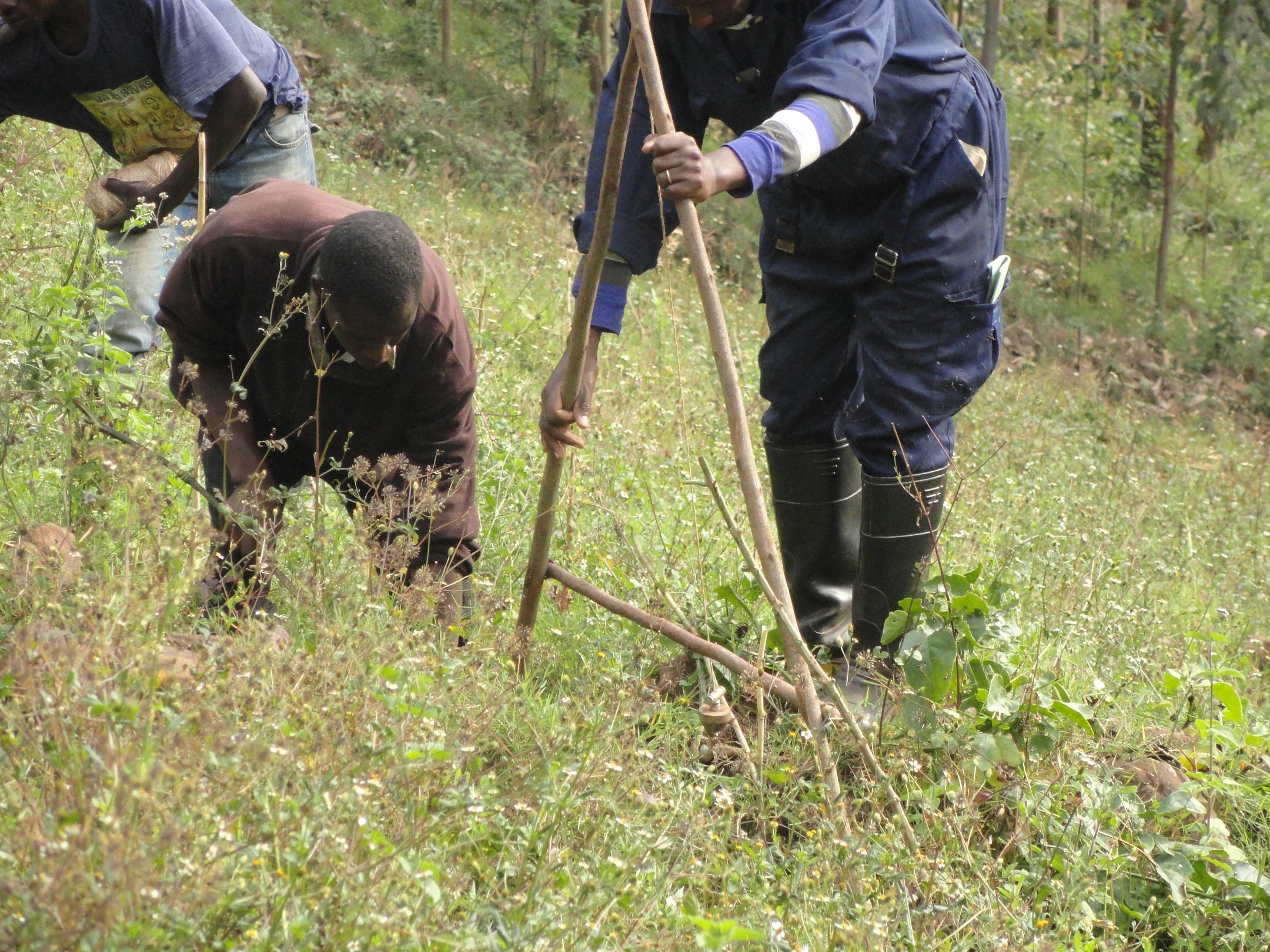
Areas which are prone to degradation by erosion are identified and later, the farmers are trained on benefits of this technology, how to set out the technology by use of the ‘A – frame’, how to construct the channels and how to maintain them by periodic de-silting and planting grasses and shrubs on the bands.
The 'A - Frame' is an A shaped structure made from wooden poles or thin metal poles that can be easily constructed and used to peg flat or graded contours or water drains.
This technology helps maintain the good top soil, which would have otherwise been washed down the slope into the valley and increases water retention.
The land users like this technology because their soil is not lost but what they dislike about this technology is that it is labour intensive, setting it out is technical and not easily conceptualized and it takes part of the land. Individual land users excavate these channels in their individual plots of land using simple hand tools like hoes, spades and pick axes.
2.3 Photos of the Technology
Media Gallery
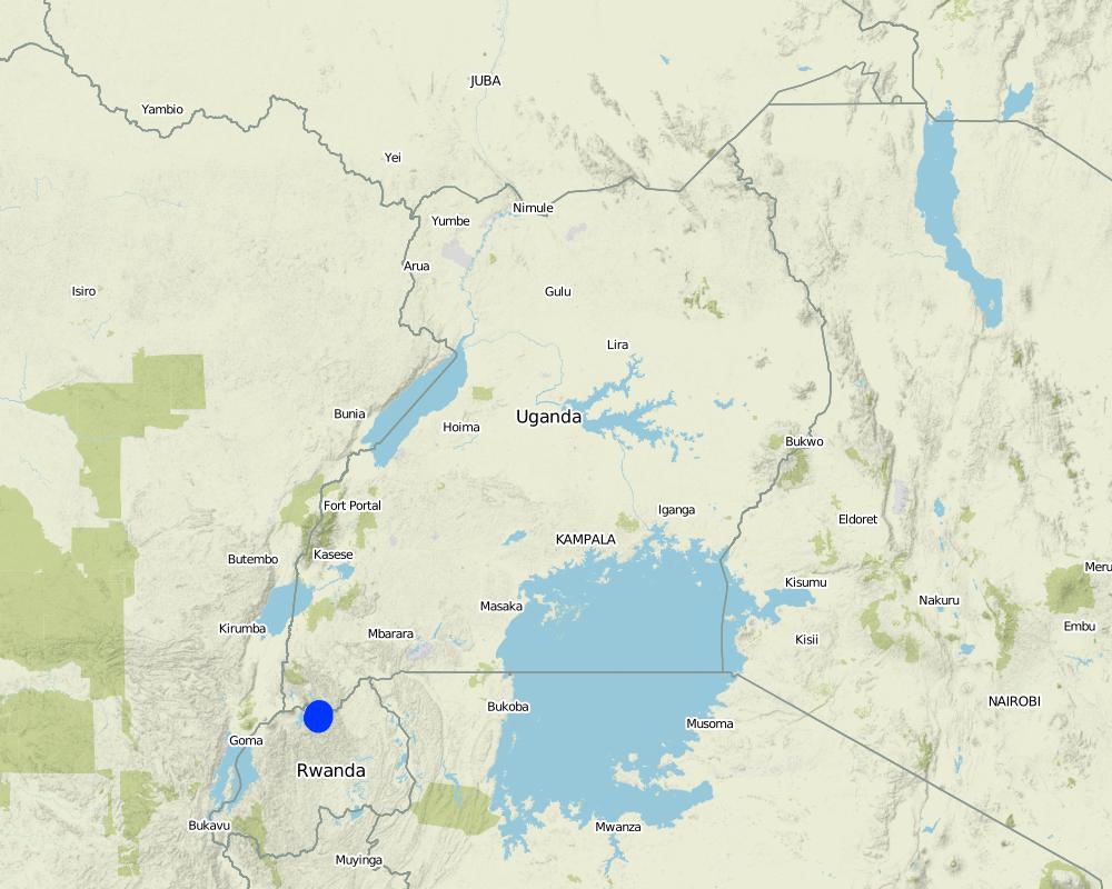
2.5 Country/ region/ locations where the Technology has been applied and which are covered by this assessment
Country:
Uganda
Region/ State/ Province:
South Western Region
Further specification of location:
Rubaya Sub County, Kabale District
Specify the spread of the Technology:
- evenly spread over an area
Comments:
rotational systems (crop rotation, fallows, shifting cultivation)
improved ground/ vegetation cover
integrated soil fertility management
Map
×2.6 Date of implementation
Indicate year of implementation:
2015
2.7 Introduction of the Technology
Specify how the Technology was introduced:
- through projects/ external interventions
Comments (type of project, etc.):
The technology was introduced under the Integrated Water Resources Management Project to support farmers to mazimise land productivity
3. Classification of the SLM Technology
3.1 Main purpose(s) of the Technology
- improve production
- reduce, prevent, restore land degradation
- conserve ecosystem
- protect a watershed/ downstream areas – in combination with other Technologies
- reduce risk of disasters
- adapt to climate change/ extremes and its impacts
- mitigate climate change and its impacts
- create beneficial economic impact
- create beneficial social impact
3.2 Current land use type(s) where the Technology is applied

Cropland
- Annual cropping
- Perennial (non-woody) cropping
Number of growing seasons per year:
- 2
Specify:
September to January and March to June
3.4 Water supply
Water supply for the land on which the Technology is applied:
- rainfed
3.5 SLM group to which the Technology belongs
- rotational systems (crop rotation, fallows, shifting cultivation)
- improved ground/ vegetation cover
- integrated soil fertility management
3.6 SLM measures comprising the Technology

vegetative measures
- V1: Tree and shrub cover
- V2: Grasses and perennial herbaceous plants

structural measures
- S3: Graded ditches, channels, waterways
3.7 Main types of land degradation addressed by the Technology

soil erosion by water
- Wt: loss of topsoil/ surface erosion
- Wg: gully erosion/ gullying
- Wm: mass movements/ landslides
3.8 Prevention, reduction, or restoration of land degradation
Specify the goal of the Technology with regard to land degradation:
- reduce land degradation
4. Technical specifications, implementation activities, inputs, and costs
4.1 Technical drawing of the Technology
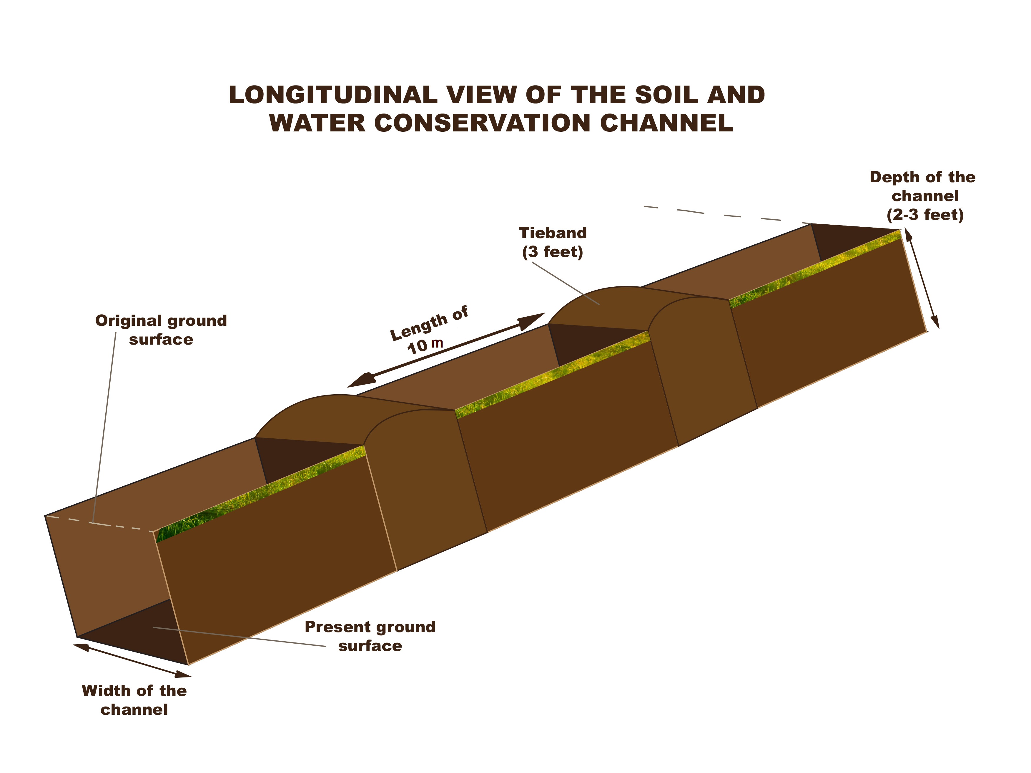
Author:
Kigezi Diocese Water and Sanitation Programme
Date:
12/12/2016
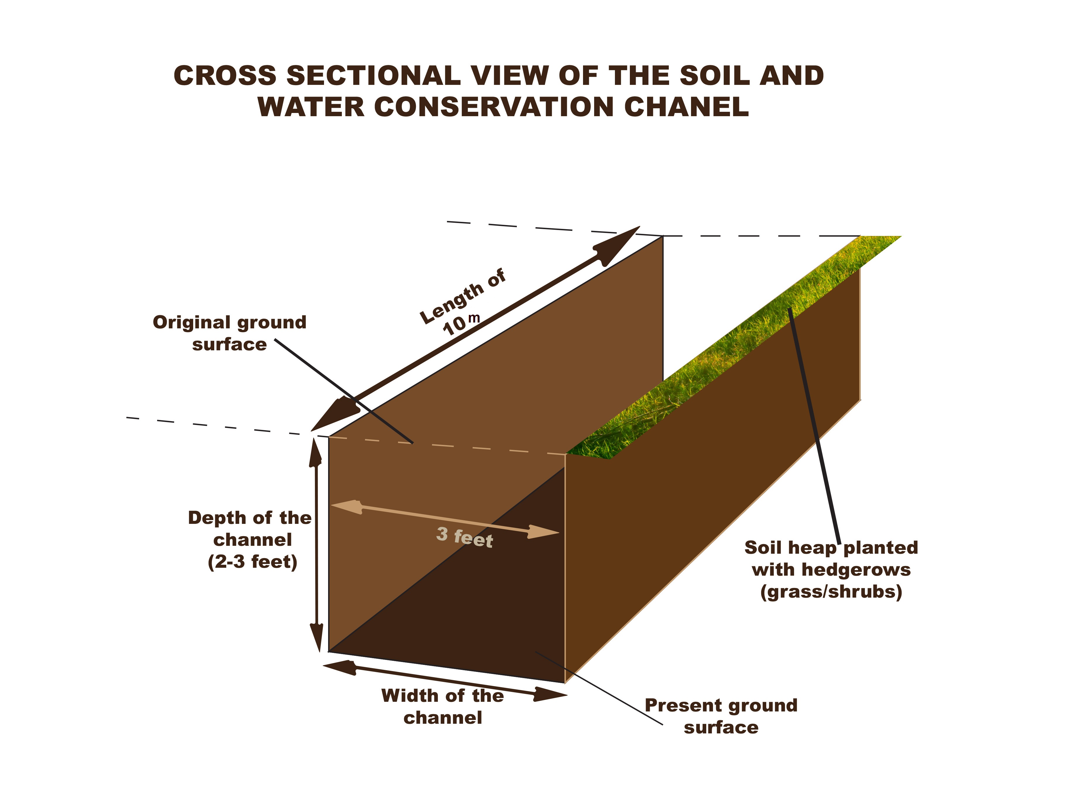
Author:
Kigezi Diocese Water and Sanitation Programme
Date:
12/12/2016
Author:
Kigezi Diocese Water and Sanitation Programme
Date:
12/12/2016
4.2 General information regarding the calculation of inputs and costs
Specify how costs and inputs were calculated:
- per Technology unit
Specify unit:
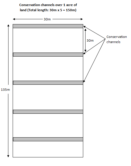
Per acre (each acre usually has 150meters of channels)
Specify currency used for cost calculations:
- USD
If relevant, indicate exchange rate from USD to local currency (e.g. 1 USD = 79.9 Brazilian Real): 1 USD =:
3300.0
Indicate average wage cost of hired labour per day:
USD 2.12
4.3 Establishment activities
| Activity | Timing (season) | |
|---|---|---|
| 1. | Setting out the soil and water conservation channel using the A-frame to set out the contour lines | After harvest of crops |
| 2. | Excavation of the soil and water conservation channel and build up soil bund on the lower side of the trench; leave a tie band every 10 meters | In the dry season |
| 3. | Planting of hedge rows on the bands | On the onset of rains |
4.4 Costs and inputs needed for establishment
| Specify input | Unit | Quantity | Costs per Unit | Total costs per input | % of costs borne by land users | |
|---|---|---|---|---|---|---|
| Labour | Setting out | meter | 150.0 | 0.02 | 3.0 | 100.0 |
| Labour | Excavation of the channels | meter | 150.0 | 1.06 | 159.0 | 100.0 |
| Labour | Planting starria grass | meter | 150.0 | 0.02 | 3.0 | 100.0 |
| Equipment | Forked hoes (1 piece can excavate 1km) | meter | 6.67 | 5.0 | 33.35 | |
| Equipment | Pick axes (1 piece can excavate 1km) | meter | 6.67 | 5.0 | 33.35 | |
| Equipment | Spades (1 piece can be used on 1km) | meter | 6.67 | 5.0 | 33.35 | |
| Plant material | Starria grass (1 sack for 20m) | sacks | 7.5 | 7.0 | 52.5 | |
| Total costs for establishment of the Technology | 317.55 | |||||
| Total costs for establishment of the Technology in USD | 0.1 | |||||
If land user bore less than 100% of costs, indicate who covered the remaining costs:
Kigezi Diocese Water and Sanitation Programme
Comments:
The land users, after being trained, set out the soil and water conservation channels for themselves but the tools are beyond the financial capacity of the land user hence the need for subsidy
4.5 Maintenance/ recurrent activities
| Activity | Timing/ frequency | |
|---|---|---|
| 1. | De-silting the channels and spreading the silt on the fields and restoring the bunds | When half full |
| 2. | Maintenance of the hedge rows by triming and replanting empty spaces | Continuous |
4.6 Costs and inputs needed for maintenance/ recurrent activities (per year)
| Specify input | Unit | Quantity | Costs per Unit | Total costs per input | % of costs borne by land users | |
|---|---|---|---|---|---|---|
| Labour | Desilting of channels (when half full) | meter | 1.0 | 0.265 | 0.27 | 100.0 |
| Labour | Trimming of hedge rows (100m per day) | days | 1.0 | 0.0212 | 0.02 | 100.0 |
| Total costs for maintenance of the Technology | 0.29 | |||||
Comments:
The initial investment of the equipment is adequate for maintenance at least for some years
4.7 Most important factors affecting the costs
Describe the most determinate factors affecting the costs:
The costs have been calculated basing on depth of top soil of 51 – 80cm. When the depth of the top soil is shallow, then the costs of breaking the underlying sub-surface layers, which are usually rock, are much higher. Also during the rainy season, the soil is more workable
The costs of maintenance will be less where the rest of the landscape also has conservation channels, has good vegetative cover and where the hill slope is gentle.
5. Natural and human environment
5.1 Climate
Annual rainfall
- < 250 mm
- 251-500 mm
- 501-750 mm
- 751-1,000 mm
- 1,001-1,500 mm
- 1,501-2,000 mm
- 2,001-3,000 mm
- 3,001-4,000 mm
- > 4,000 mm
Specifications/ comments on rainfall:
Bi-modal rainfall pattern with long rainy season from September to December then March to May
Indicate the name of the reference meteorological station considered:
Kabale District Meterological Department
Agro-climatic zone
- sub-humid
5.2 Topography
Slopes on average:
- flat (0-2%)
- gentle (3-5%)
- moderate (6-10%)
- rolling (11-15%)
- hilly (16-30%)
- steep (31-60%)
- very steep (>60%)
Landforms:
- plateau/plains
- ridges
- mountain slopes
- hill slopes
- footslopes
- valley floors
Altitudinal zone:
- 0-100 m a.s.l.
- 101-500 m a.s.l.
- 501-1,000 m a.s.l.
- 1,001-1,500 m a.s.l.
- 1,501-2,000 m a.s.l.
- 2,001-2,500 m a.s.l.
- 2,501-3,000 m a.s.l.
- 3,001-4,000 m a.s.l.
- > 4,000 m a.s.l.
Indicate if the Technology is specifically applied in:
- not relevant
5.3 Soils
Soil depth on average:
- very shallow (0-20 cm)
- shallow (21-50 cm)
- moderately deep (51-80 cm)
- deep (81-120 cm)
- very deep (> 120 cm)
Soil texture (topsoil):
- medium (loamy, silty)
Soil texture (> 20 cm below surface):
- medium (loamy, silty)
Topsoil organic matter:
- medium (1-3%)
5.4 Water availability and quality
Ground water table:
> 50 m
Availability of surface water:
good
Water quality (untreated):
poor drinking water (treatment required)
Is water salinity a problem?
No
Is flooding of the area occurring?
Yes
Regularity:
episodically
Comments and further specifications on water quality and quantity:
Water quantity and quality is dependent on human activities and rainfall patterns
5.5 Biodiversity
Species diversity:
- medium
Habitat diversity:
- medium
5.6 Characteristics of land users applying the Technology
Sedentary or nomadic:
- Sedentary
Market orientation of production system:
- subsistence (self-supply)
- mixed (subsistence/ commercial)
Off-farm income:
- less than 10% of all income
Relative level of wealth:
- poor
Individuals or groups:
- individual/ household
Level of mechanization:
- manual work
Gender:
- women
- men
Age of land users:
- youth
- middle-aged
5.7 Average area of land used by land users applying the Technology
- < 0.5 ha
- 0.5-1 ha
- 1-2 ha
- 2-5 ha
- 5-15 ha
- 15-50 ha
- 50-100 ha
- 100-500 ha
- 500-1,000 ha
- 1,000-10,000 ha
- > 10,000 ha
5.8 Land ownership, land use rights, and water use rights
Land ownership:
- individual, not titled
Land use rights:
- individual
Water use rights:
- communal (organized)
5.9 Access to services and infrastructure
health:
- poor
- moderate
- good
education:
- poor
- moderate
- good
technical assistance:
- poor
- moderate
- good
employment (e.g. off-farm):
- poor
- moderate
- good
markets:
- poor
- moderate
- good
energy:
- poor
- moderate
- good
roads and transport:
- poor
- moderate
- good
drinking water and sanitation:
- poor
- moderate
- good
financial services:
- poor
- moderate
- good
6. Impacts and concluding statements
6.1 On-site impacts the Technology has shown
Socio-economic impacts
Production
crop production
Comments/ specify:
The impacts are seen immediately after the first crop
crop quality
fodder production
fodder quality
risk of production failure
production area
land management
Income and costs
expenses on agricultural inputs
farm income
diversity of income sources
workload
Socio-cultural impacts
food security/ self-sufficiency
health situation
community institutions
SLM/ land degradation knowledge
conflict mitigation
Ecological impacts
Water cycle/ runoff
surface runoff
groundwater table/ aquifer
Soil
soil moisture
soil cover
soil loss
soil accumulation
soil organic matter/ below ground C
Climate and disaster risk reduction
flood impacts
6.2 Off-site impacts the Technology has shown
water availability
downstream flooding
damage on neighbours' fields
damage on public/ private infrastructure
6.3 Exposure and sensitivity of the Technology to gradual climate change and climate-related extremes/ disasters (as perceived by land users)
Gradual climate change
Gradual climate change
| Season | increase or decrease | How does the Technology cope with it? | |
|---|---|---|---|
| annual temperature | increase | not known | |
| seasonal temperature | wet/ rainy season | increase | not known |
| seasonal temperature | dry season | increase | not known |
| annual rainfall | decrease | well | |
| seasonal rainfall | wet/ rainy season | decrease | well |
Climate-related extremes (disasters)
Meteorological disasters
| How does the Technology cope with it? | |
|---|---|
| local rainstorm | well |
| local thunderstorm | well |
| local hailstorm | well |
Climatological disasters
| How does the Technology cope with it? | |
|---|---|
| land fire | well |
Hydrological disasters
| How does the Technology cope with it? | |
|---|---|
| general (river) flood | very well |
| flash flood | very well |
| landslide | well |
Biological disasters
| How does the Technology cope with it? | |
|---|---|
| epidemic diseases | moderately |
| insect/ worm infestation | not known |
6.4 Cost-benefit analysis
How do the benefits compare with the establishment costs (from land users’ perspective)?
Short-term returns:
positive
Long-term returns:
very positive
How do the benefits compare with the maintenance/ recurrent costs (from land users' perspective)?
Short-term returns:
positive
Long-term returns:
very positive
Comments:
The adoption rate of this technology is gradual as people keep appreciating the benefits
6.5 Adoption of the Technology
- 1-10%
Of all those who have adopted the Technology, how many did so spontaneously, i.e. without receiving any material incentives/ payments?
- 0-10%
6.6 Adaptation
Has the Technology been modified recently to adapt to changing conditions?
No
6.7 Strengths/ advantages/ opportunities of the Technology
| Strengths/ advantages/ opportunities in the land user’s view |
|---|
| 1) It controls soil loss from the land users garden |
| 2) It provides silt which is spread in their garden |
| 3) Hedge rows are used as fodder and as mulching material |
| 4) The conserved water is used to benefit the plants in the same garden |
| Strengths/ advantages/ opportunities in the compiler’s or other key resource person’s view |
|---|
| 1) It improves water percolation in the soil which increases soil moisture content and increases ground water recharge |
| 2) It is a simple technology which uses simple hand tools |
| 3) It reduces conflicts related to land being washed into the neighbours plot since land is fragmented |
6.8 Weaknesses/ disadvantages/ risks of the Technology and ways of overcoming them
| Weaknesses/ disadvantages/ risks in the land user’s view | How can they be overcome? |
|---|---|
| 1) This technology requires a lot of hard labour | The land users were encouraged to form small groups which work together to ease the work and share knowledge and skill |
| 2) Land users feel that the channels take up alot of their land, which would otherwise be used for growing crops | The land users have been helped to appreciate the benefits of the technology in making the seemingly smaller land more productive |
| Weaknesses/ disadvantages/ risks in the compiler’s or other key resource person’s view | How can they be overcome? |
|---|---|
| 1) This technology is dependent on land users continued efforts in de-silting and maintenance of the hedge rows. When this is not done the technology fails | Land users are encouraged to periodically desilt the channels |
| 2) The effectiveness of this technology is dependent on the compliance of other land users in the landscape. For example if it is done downhill and not uphill, then the channels will be overwhelmed by the volume of the soil and water runoff | All community members were sensitised on the importance and effectiveness of this technology and existing by-laws will foster members uphill to practice the technology. The benefits of the technology will encourage other land users to adopt it |
| 3) The process of maintaining and rolling out this technology requires engagement of many stakeholders | Management structures, which are well linked with government structures, have been set up and trained at various levels to manage the process of maintaining and rolling out the technology |
7. References and links
7.1 Methods/ sources of information
- field visits, field surveys
Observation field visits to the different land users
- interviews with land users
Focus group discussion with 18 land users
- interviews with SLM specialists/ experts
Interviews with programme (KDWSP) staff
- compilation from reports and other existing documentation
Information gathered from programme progress reports and Ministry of Water and Environment Documentation
When were the data compiled (in the field)?
07/09/2016
7.2 References to available publications
Title, author, year, ISBN:
Kigezi Diocese Water and Sanitation Programme, IWRM Annual Report (April 2015 - March 2016)
Available from where? Costs?
www.kigezi-watsan.ug
Title, author, year, ISBN:
IWRM Pilot report 2013
Available from where? Costs?
www.kigezi-watsan.ug
7.3 Links to relevant online information
Title/ description:
Handbook of chennel design for soil and water conservation
URL:
www.worldwidehelpers.org
Title/ description:
Soil conservation handbook
URL:
www.wcc.nrcs.usda.gov/ftpref/wntsc/H&H/TRsTPs/TP61.pdf
Title/ description:
Soil conservation
URL:
http://www.fao.org/docrep/t0321e/t0321e-10.htm
Links and modules
Expand all Collapse allLinks
Catchment Based Integrated Water Resources Management [Uganda]
Catchment based integrated water resources management is a process which promotes the coordinated development and management of water, land and related resources in order to maximise economic and social welfare in an equitable manner without compromising the sustainability of vital eco systems
- Compiler: Philip Tibenderana
Modules
No modules