Community Land Use Planning in Arkhiloskalo [Georgia]
- Creación:
- Actualización:
- Compilador: Hanns Kirchmeir
- Editor: Kety Tsereteli
- Revisor: Rima Mekdaschi Studer
technologies_5762 - Georgia
Visualizar secciones
Expandir todo Colapsar todos1. Información general
1.2 Detalles de contacto de las personas de referencia e instituciones involucradas en la evaluación y la documentación de la Tecnología
Especialista MST:
Nombre del proyecto que financió la documentación/ evaluación de la Tecnología (si fuera relevante)
Applying Landscape and Sustainable Land Management (L-SLM) for mitigating land degradation and contributing to poverty reduction in rural area (L-SLM Project)Nombre de la(s) institución(es) que facilitaron la documentación/ evaluación de la Tecnología (si fuera relevante)
Regional Environmental Centre for the Caucasus (REC Caucasus) - Georgia1.3 Condiciones referidas al uso de datos documentados mediante WOCAT
El compilador y la/s persona(s) de referencia claves aceptan las condiciones acerca del uso de los datos documentados mediante WOCAT:
Sí
1.4 Declaración de la sostenibilidad de la Tecnología descrita
¿La Tecnología aquí descrita resulta problemática en relación a la degradación de la tierra, de tal forma que no puede considerársela una tecnología sostenible para el manejo de la tierra?
No
1.5 Referencia al (los) Cuestionario(s) de Enfoques MST (documentados usando WOCAT)
Land Degradation Neutrality Transformative Projects and Programmes (LDN-TPP) … [Georgia]
In the framework of the project ‘Generating Economic and Environmental Benefits from Sustainable Land Management for Vulnerable Rural Communities of Georgia’, Land Degradation Neutrality Transformative Projects and Programmes (LDN-TPP) were developed to implement the LDN targets at municipal level. The approach defines the process to break down global and international …
- Compilador: Daniel Zollner
2. Descripción de la Tecnología MST
2.1 Breve descripción de la Tecnología
Definición de la Tecnología:
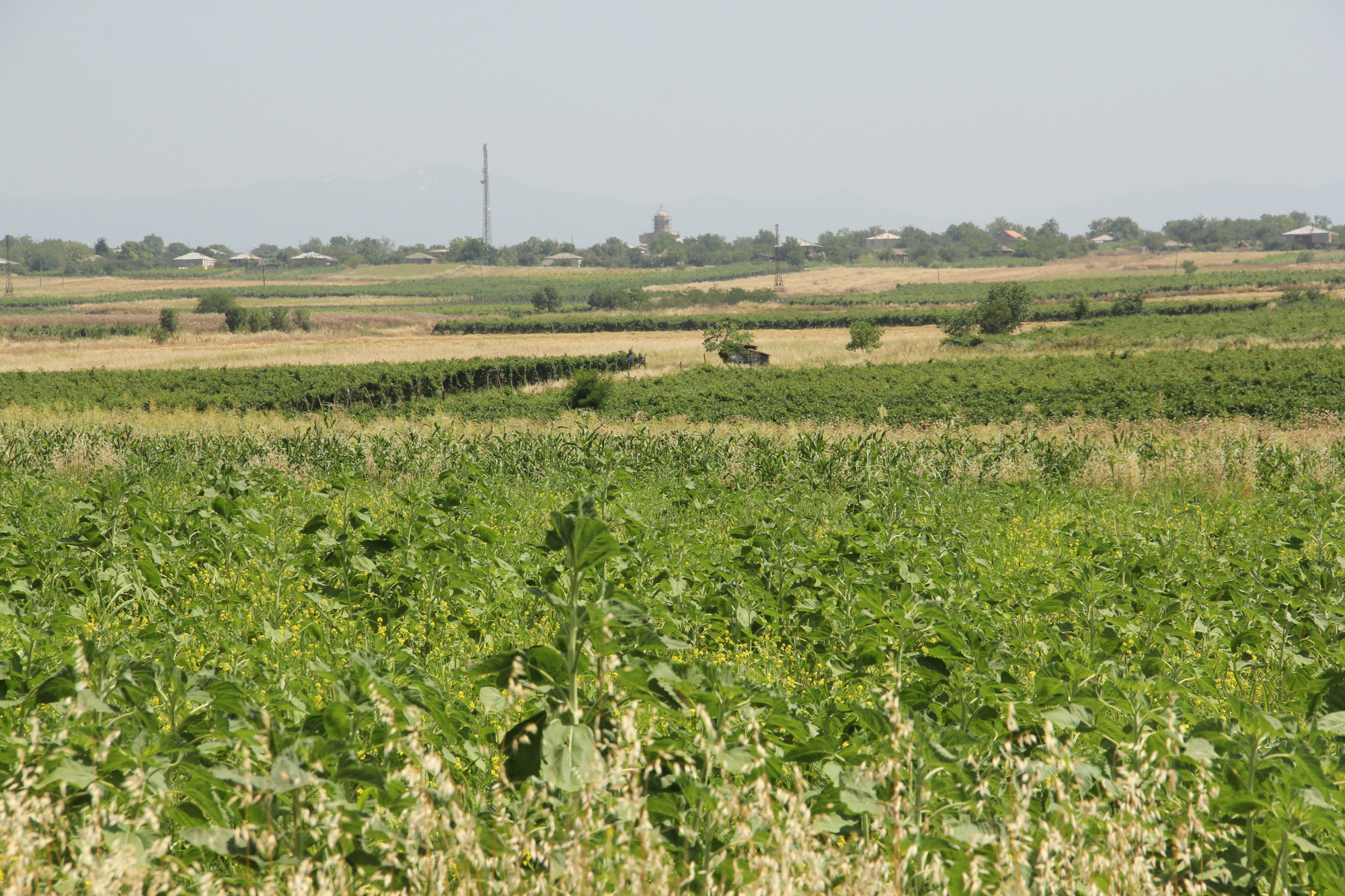
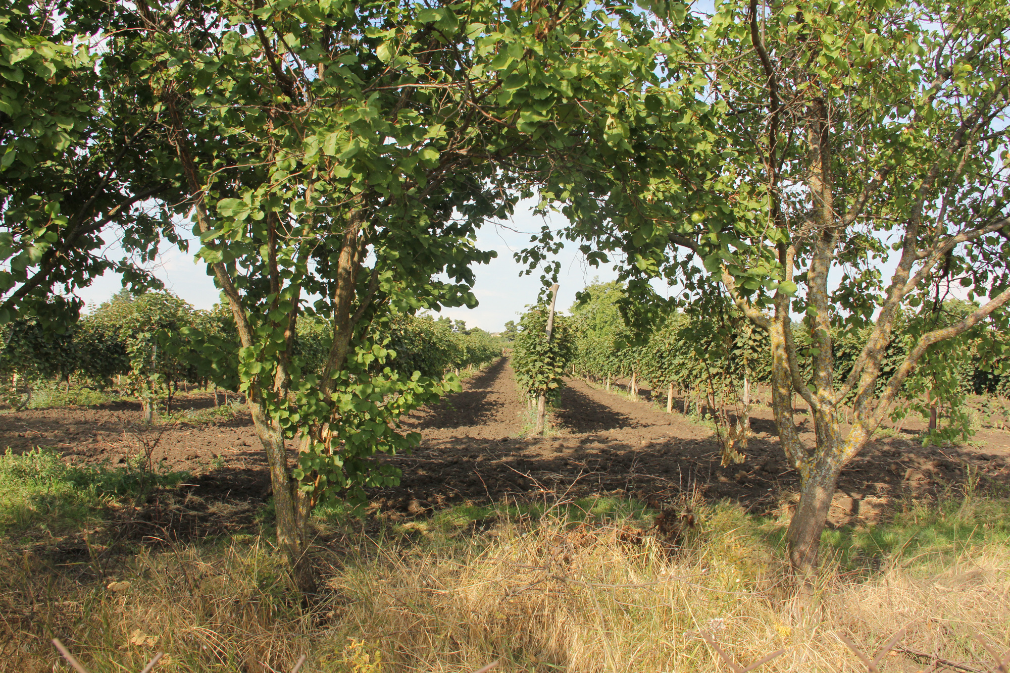
Unsustainable land use practices, such as deforestation, overgrazing and improper agricultural management systems are triggering the loss and degradation of valuable land resources in Georgia. Land use planning is one of the measures among others to contribute to support the integration of good Landscape and Sustainable Land Management (L-SLM) principles and practices into national policy and institutional framework to ensure the adoption of economically viable practices by rural communities. This technology is demonstrated in an application in Arkhiloskalo community in Eastern Georgia.
2.2 Descripción detallada de la Tecnología
Descripción:
The globally ongoing degradation of land resources is threatening our food security and functioning ecosystem services. Therefore, restoration of degraded land as defined by the Sustainable Development Goal (SDG 15.3) has become a strategic objective of the UNCCD. To achieve Land Degradation Neutrality (LDN), action on the national level is needed. Georgia is one of the 113 countries (as of Sept. 2017) willing to take part in the Target Setting Program (TSP).
One of the major problems which Georgia is facing today is an absence of a comprehensive and integrated approach in the land management sector. In addition, an irrelevant legal framework sometimes leads to additional “conflicts” with the evolved national strategy and policy packages.
The land-use planning in the village of Arkhiloskalo, Dedoplistskaro Municipality is one of the pilot activities linked to LDN (Land Degradation Neutrality). The project financed by Global Environment Facility (GEF) / UN Environment Programm (UNEP) was implemented by local partner REC Caucasus (The Regional Environmental Centre for the Caucasus) through E.C.O. Institute of Ecology (Austria).
The land-use plan documents the status quo of the current land use. It is a baseline that can be used to steer and monitor future developments. The land-use plan is based on field assessments made in summer 2019 and builds a baseline for future assessments/monitoring. The land-use plan on the village level helps to break down national LDN targets to the local level. The plan and the development of land-use scenarios help to anticipate the future gains and losses of land resources and reflect the national LDN-target on the local level. Local stakeholders can identify areas of degradation risk and areas which can be rehabilitated. The Arkhiloskalo land-use plan contributes to sustainable land use by recognizing the current situation of land use and its spatial distribution as well as identifying the strength and weaknesses of the current situation.
Methodology:
Mapping for Arkhiloskalo land use plan: The mapping result is a detailed documentation of size and spatial distribution of land cover categories. Change in land cover is an important indicator to monitor the loss and gains of land resources according to the LDN monitoring concept.
For the mapping of the settlements, arable land and gardens, maps from Google Earth and digital cadastre of parcels were used. In the field maps, each polygon has an assigned Map-ID number, which is unique for each village. Polygons with the same land use category and land-use intensity can have the same Map-ID. Next to the drawing of the polygon on the map, in a field form each polygon is described by:
- Map-ID;
- Current Land use category;
- Current Land-use intensity;
- Remark (a specification of the polygon if needed).
Classifications of land use categories: The land-use classification is based on the CLC - Corine Land Classification System (The CORINE Land Cover is a vector map with a scale of 1:10 000, a minimum cartographic unit (MCU) of 100 m². It maps homogeneous landscape patterns). The Corine Land Classification system classifies urban fabric, mine, dump and construction sites, arable land, permanent crops, pastures, forests, shrubs and herbaceous vegetation associations, Open spaces with little or no vegetation, inland wetlands and waters.
The pastureland was differentiated into different productivity classes. In the field three classes of vegetation cover and species composition: low, medium, and high productivity were assessed.
For the mapping in Arkhiloskalo the following land use categories were selected: Settlements and human infrastructure (Code from the Corine Land Classification system – e.g. SHR, name – e.g. Houses); Forests and shrub-land; Agricultural managed land; Natural and semi-natural habitats.
2.3 Fotografías de la Tecnología
Galería de medios
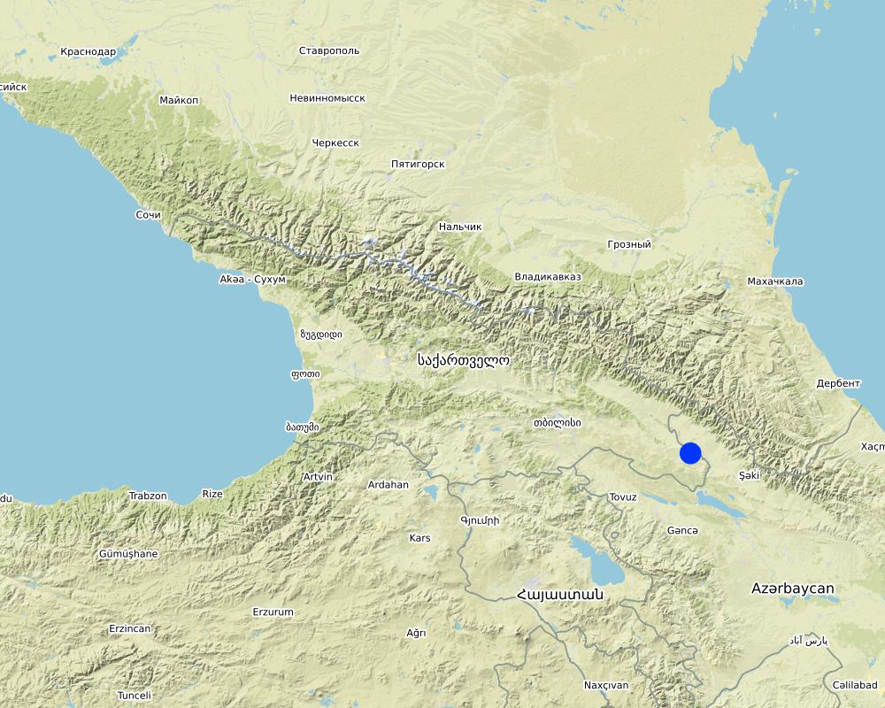
2.5 País/ región/ lugares donde la Tecnología fue aplicada y que se hallan comprendidos por esta evaluación
País:
Georgia
Región/ Estado/ Provincia:
Kakheti
Especifique más el lugar :
The Village of Arkhiloskalo is locted in the Municipality of Dedoplitskaro.
Especifique la difusión de la Tecnología:
- distribuida parejamente sobre un área
Si la Tecnología se halla difundida homogéneamente a lo largo de un área, especifique el área que cubre (en km2):
49,7
Si se desconoce el área precisa, indique el área aproximada cubierta:
- 10-100 km2
Comentarios:
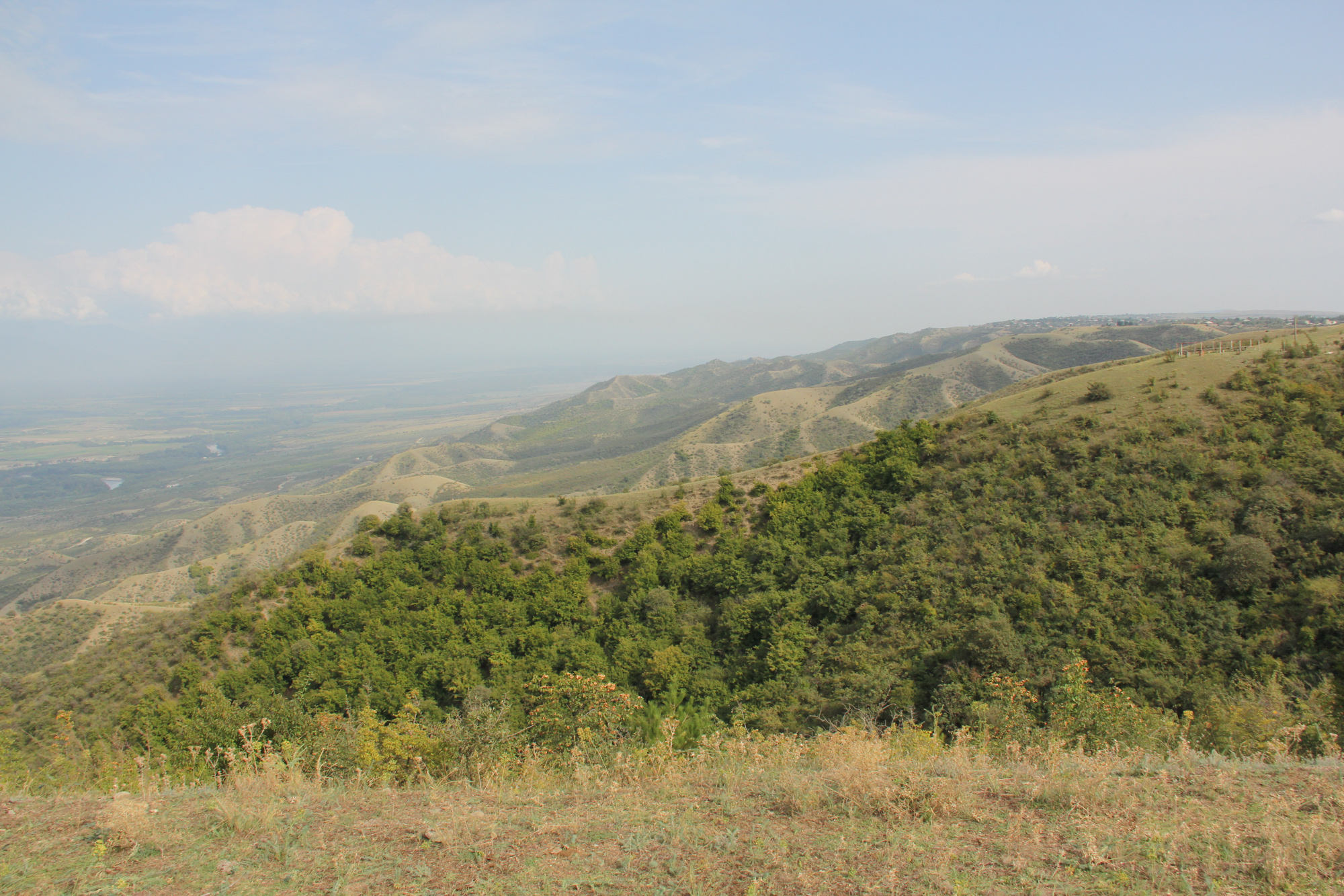
The village Arkhiloskalo covers an area of 4,970 ha. The area ranges from the lower section in the North 250 m (Alasani river valley) up to 730 m at the ridge and then falls again to the South in the Shiraki Valley to 600 m.
Map
×2.6 Fecha de la implementación
Indique año de implementación:
2018
2.7 Introducción de la Tecnología
Especifique cómo se introdujo la Tecnología:
- mediante proyectos/ intervenciones externas
Comentarios (tipo de proyecto, etc.):
The land-use plan approach is one of the measures among others to contribute to support the integration of good Landscape and Sustainable Land Management (L-SLM) principles and practices into national policy and institutional framework to ensure the adoption of economically viable practices by rural communities. This was a GEF-funded project.
3. Clasificación de la Tecnología MST
3.1 Propósito(s) principal(es) de la Tecnología MST
- mejorar la producción
- reducir, prevenir, restaurar la degradación del suelo
- preservar/ mejorar biodiversidad
- adaptarse al cambio climático/ extremos climáticos y sus impactos
- crear impacto económico benéfico
3.2 Tipo(s) actuales de uso de la tierra donde se aplica la Tecnología
Mezcla de tipos de uso de tierras dentro de la misma unidad de tierras: :
Sí
Especifique el uso combinado de tierras (cultivos/ pastoreo/ árboles):
- Agroforestería

Tierras cultivadas
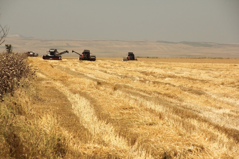
- Cosecha anual
- Cosecha de árboles y arbustos
Cosechas anuales - Especifique cultivos:
- cereales - trigo (verano)
- cereales - trigo (invierno)
- cultivos de semillas oleaginosas - girasol, colza, otros
Cultivos de matorrales y arbustos - Especifique cultivos:
- frutas, otros
- uvas
Número de temporadas de cultivo por año:
- 1
Especifique:
summer
¿Se practica el intercultivo?
No
¿Se practica la rotación de cultivos?
No

Tierra de pastoreo
Pastoreo extenso:
- Ganadería de hacienda
Pastoreo intensivo/ producción de forraje:
- Cortar y llevar/ cero pastoreo
- Pastoreo mejorado
Tipo de animal:
- cattle - dairy and beef (e.g. zebu)
¿Se practica el manejo integrado de cultivos - ganado?
No
Especies:
cattle - dairy and beef (e.g. zebu)
Conteo:
982

asentamientos, infraestructura
- Asentamientos, edificios
- Tráfico: caminos, rieles
Comentarios:
All form of land cover and land use forms have been mapped.
3.3 ¿Cambió el uso de tierras debido a la implementación de la Tecnología?
¿Cambió el uso de tierras debido a la implementación de la Tecnología?
- No (Continúe con la pregunta 3.4)
3.4 Provisión de agua
Provisión de agua para la tierra donde se aplica la Tecnología:
- de secano
3.5 Grupo MST al que pertenece la Tecnología
- rompevientos/ cinturones de protección
- sistemas de rotación (rotación de cosecha, cosecha rotatoria con descanso, agricultura migratoria)
- manejo de desperdicios/ manejo de aguas residuales
- Land use planning
3.6 Medidas MST que componen la Tecnología

medidas de manejo
- M2: Cambio de gestión/ nivel de intensidad
- M7: Otros
Comentarios:
The land use planning started with mapping of current land use and included stakeholders input on strength and weaknesses. Based on this, development scenarios have been developed to change current land use approaches to a more sustainable way (e.g. restoration of windbreaks, crop rotation etc.)
3.7 Principales tipos de degradación del suelo encarados con la Tecnología

erosión de suelos por viento
- Et: pérdida de capa arable
Comentarios:
The loss of windbreaks caused an increased exposure of topsoil to wind erosion on fields with annual crops. The land use plan helps to quantify the current state of the windbreaks and underlines their functional importance.
3.8 Prevención, reducción o restauración de la degradación del suelo
Especifique la meta de la Tecnología con relación a la degradación de la tierra:
- prevenir la degradación del suelo
4. Especificaciones técnicas, actividades de implementación, insumos y costos
4.1 Dibujo técnico de la Tecnología
Especificaciones técnicas (relacionadas al dibujo técnico):
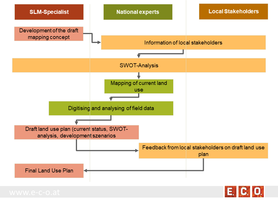
Key stages of implementation:
The land-use planning in the village of Arkhiloskalo, Dedoplistskaro Municipality is one of the pilot activities linked to LDN.
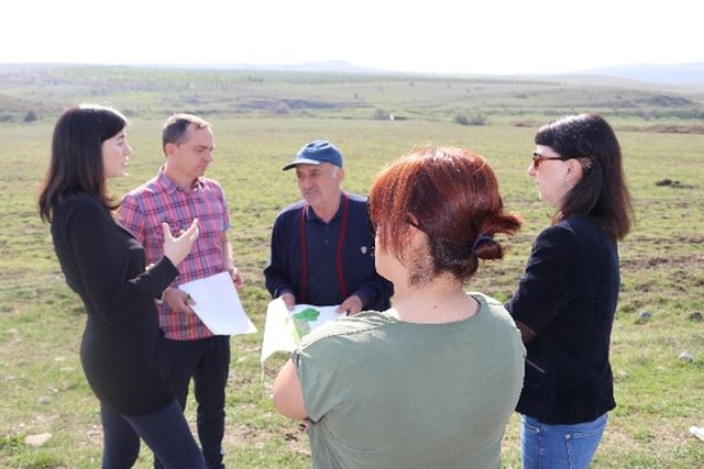
Together with the local stakeholders, a land-use plan has been worked out. The procedure of defining a spatial development plan for a municipality goes along three stages:
• Stage 1: Gather background information & implement pre-design studies and development of a mapping concept
• Stage 2: Information of local stakeholders on this activity and implementation of an SWOT analysis (Strength, Weaknesses, Opportunities, Threats) related to the land use of the village
• Stage 3: Mapping and analyzing the current land use
• Stage 4: Preparation of a draft land use plan
• Stage 5: Reflection of the draft land use plan with local stakeholders
• Stage 6: Preparation of the final land use plan
Autor:
Hanns Kirchmeir
Fecha:
16/01/2020
Especificaciones técnicas (relacionadas al dibujo técnico):
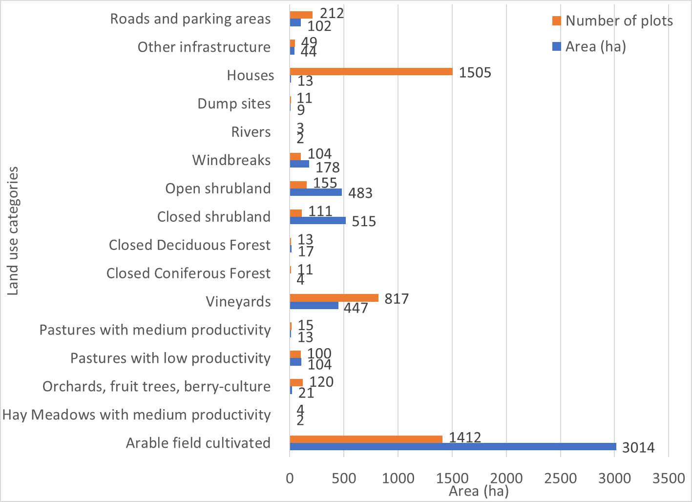
Absolute area sizes. The largest land use category is arable land (3,014 ha) followed by closed and open shrubland (515 ha and 483 ha, respectively). Vineyards cover a total of 447 ha whereas windbreaks cover 178 ha. Pastures with low productivity (104 ha) and roads and parking areas (102 ha) use almost the same amount of land. Other infrastructure covers 44 ha of land. Orchards, fruit trees and berry-culture use 21 ha of land. Closed deciduous forest (17 ha) covers only a few more hectares than pastures (13 ha). Houses are the most common plot category in Arkhiloskalo but use only around 13 ha of land which puts them on the same land-use level as pastures. Dumpsites (9 ha) use more than twice the area of closed coniferous forest (4 ha). Hay meadows and rivers cover around 2 ha of the area.
Autor:
Hanns Kirchmeir
Fecha:
20/11/2019
Especificaciones técnicas (relacionadas al dibujo técnico):
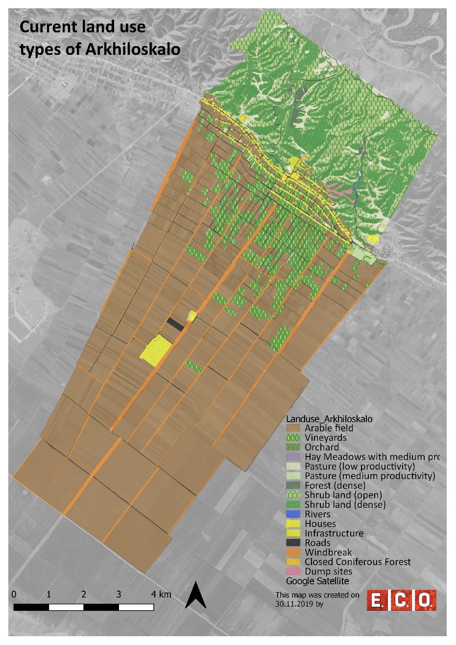
Map of current land-use categories in Arkhiloskalo. The land-use classification in this approach is based on the Corine Land Classification System. It was split into sub-categories where needed to meet the needs of local land use practices.
Autor:
Hanns Kirchmeir
Fecha:
13/11/2019
Especificaciones técnicas (relacionadas al dibujo técnico):
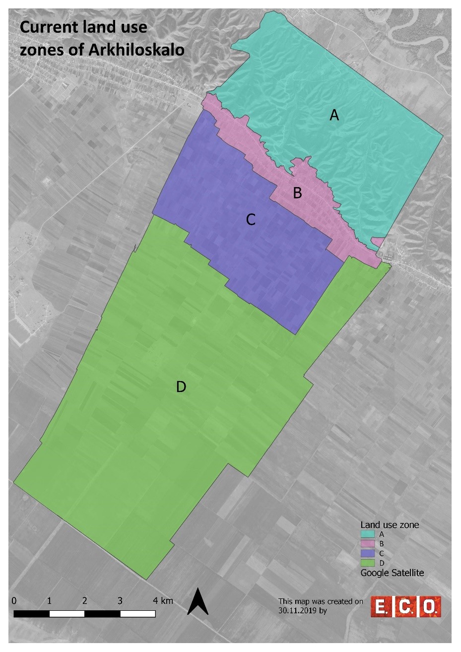
Based on the different land use, 4 different zones have been separated:
•Zone A: Steep North Slope
•Zone B. Settlement Area
•Zone C: Zone of perennial Crops
•Zone D: Zone of annual Crops
Autor:
Hanns Kirchmeir
4.2 Información general sobre el cálculo de insumos y costos
Especifique cómo se calcularon los costos e insumos:
- por área de Tecnología
Indique tamaño y unidad de área:
50 km²
Especifique la moneda usada para calcular costos:
- USD
Indique el costo promedio del salario de trabajo contratado por día:
national expert 100 USD
4.3 Actividades de establecimiento
| Actividad | Momento (estación) | |
|---|---|---|
| 1. | Gather background information & implement pre-design studies and development of a mapping concept | Winter/spring |
| 2. | Information of local stakeholders on this activity and implementation of an SWOT analysis (Strength, Weaknesses, Opportunities, Threats) related to the land use of the village | Spring |
| 3. | Mapping and analyzing the current land use | Summer |
| 4. | Preparation of a draft land use plan | Autumn/Winter |
| 5. | Reflection of the draft land use plan with local stakeholders | Autumn/Winter |
| 6. | Preparation of the final land use plan | Autumn/Winter |
4.4 Costos e insumos necesarios para el establecimiento
Si no puede desglosar los costos especificados en la tabla anterior, proporcione un estimado de los cálculos totales en los que se incurrió para establecer la Tecnología:
15000,0
Si el usuario de la tierra no cubrió el 100% de los costos, indique quién financió el resto del costo:
REC-Caucasus, GEF-funded Project
Comentarios:
The budget is $ 15 000 / per year. This amount includes the salaries of following expert, such as: National expert on SLM, National expert on LUP, International expert on SLM, International expert on LUP, Botanist, GIS expert. Also the above budget includes travels and missions in three municipalities, workshops in Akhmeta and Dedoplistskaro municipalities, workshops and public hearings in selected local communities (Arkhiloskalo and Shenako),
4.7 Factores más determinantes que afectan los costos:
Describa los factores más determinantes que afectan los costos:
The field work of mapping and analysis of results took a lot of time as well as the stakeholder meetings.
5. Entorno natural y humano
5.1 Clima
Lluvia anual
- < 250 mm
- 251-500 mm
- 501-750 mm
- 751-1,000 mm
- 1,001-1,500 mm
- 1,501-2,000 mm
- 2,001-3,000 mm
- 3,001-4,000 mm
- > 4,000 mm
Especificaciones/ comentarios sobre la cantidad de lluvia:
The driest month is January, with 25 mm of rainfall. The greatest amount of precipitation occurs in June, with an average of 108 mm. The difference in precipitation between the driest month and the wettest month is 83 mm.
Indique el nombre de la estación metereológica de referencia considerada:
Dedoplistskaro Met. Station
Zona agroclimática
- semi-árida
The climate is warm and temperate in Dedoplistskaro. The average annual temperature in Dedoplistskaro is 11.3 °C. The warmest month of the year is July, with an average temperature of 22.7 °C. The lowest average temperatures in the year occur in January, when it is around 0.1 °C.
5.2 Topografía
Pendientes en promedio:
- plana (0-2 %)
- ligera (3-5%)
- moderada (6-10%)
- ondulada (11-15%)
- accidentada (16-30%)
- empinada (31-60%)
- muy empinada (>60%)
Formaciones telúricas:
- meseta/ planicies
- cordilleras
- laderas montañosas
- laderas de cerro
- pies de monte
- fondo del valle
Zona altitudinal:
- 0-100 m s.n.m.
- 101-500 m s.n.m.
- 501-1,000 m s.n.m
- 1,001-1,500 m s.n.m
- 1,501-2,000 m s.n.m
- 2,001-2,500 m s.n.m
- 2,501-3,000 m s.n.m
- 3,001-4,000 m s.n.m
- > 4,000 m s.n.m
Indique si la Tecnología se aplica específicamente en:
- no relevante
Comentarios y especificaciones adicionales sobre topografía :
The pastures are located on steep hill slope to the north, while the village and arable lands are located on the gently south facing terrace.
5.3 Suelos
Profundidad promedio del suelo:
- muy superficial (0-20 cm)
- superficial (21-50 cm)
- moderadamente profunda (51-80 cm)
- profunda (81-120 cm)
- muy profunda (>120 cm)
Textura del suelo (capa arable):
- mediana (limosa)
Textura del suelo (> 20 cm debajo de la superficie):
- mediana (limosa)
Materia orgánica de capa arable:
- elevada (>3%)
5.4 Disponibilidad y calidad de agua
Agua subterránea:
5-50 m
Disponibilidad de aguas superficiales:
pobre/ ninguna
Calidad de agua (sin tratar):
agua potable de mala calidad (requiere tratamiento)
La calidad de agua se refiere a:
agua subterránea
¿La salinidad del agua es un problema?
No
¿Se está llevando a cabo la inundación del área? :
No
5.5 Biodiversidad
Diversidad de especies:
- elevada
Diversidad de hábitats:
- elevada
Comentarios y especificaciones adicionales sobre biodiversidad:
Especially the semi-natural landscapes of the slopes to the north are of high habitat and species diversity.
5.6 Las características de los usuarios de la tierra que aplican la Tecnología
Sedentario o nómada:
- Sedentario
Orientación del mercado del sistema de producción:
- mixta (subsistencia/ comercial)
Ingresos no agrarios:
- menos del 10% de todos los ingresos
Nivel relativo de riqueza:
- pobre
Individuos o grupos:
- individual/ doméstico
Nivel de mecanización:
- mecanizado/motorizado
Género:
- hombres
Edad de los usuarios de la tierra:
- personas de mediana edad
Indique otras características relevantes de los usuarios de las tierras:
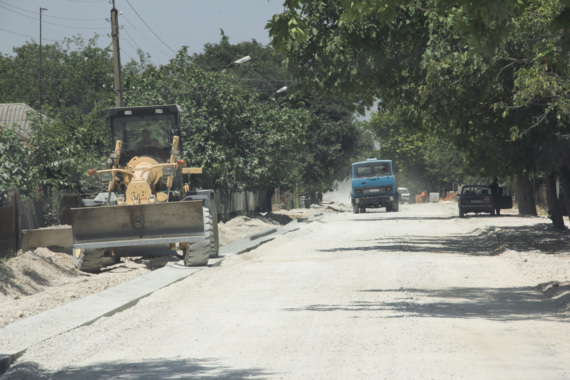
The village is very remote. Driving distance to the municipality is about 1h on bad roads.
5.7 Área promedio de la tierra usada por usuarios de tierra que aplican la Tecnología
- < 0.5 ha
- 0.5-1 ha
- 1-2 ha
- 2-5 ha
- 5-15 ha
- 15-50 ha
- 50-100 ha
- 100-500 ha
- 500-1,000 ha
- 1,000-10,000 ha
- > 10,000 ha
¿Esto se considera de pequeña, mediana o gran escala (refiriéndose al contexto local)?
- escala mediana
5.8 Tenencia de tierra, uso de tierra y derechos de uso de agua
Tenencia de tierra:
- comunitaria/ aldea
- individual, con título
Derechos de uso de tierra:
- acceso abierto (no organizado)
- individual
Derechos de uso de agua:
- comunitarios (organizado)
¿Los derechos del uso de la tierra se basan en un sistema legal tradicional?
Sí
5.9 Acceso a servicios e infraestructura
salud:
- pobre
- moderado
- bueno
educación:
- pobre
- moderado
- bueno
asistencia técnica:
- pobre
- moderado
- bueno
mercados:
- pobre
- moderado
- bueno
energía:
- pobre
- moderado
- bueno
caminos y transporte:
- pobre
- moderado
- bueno
agua potable y saneamiento:
- pobre
- moderado
- bueno
servicios financieros:
- pobre
- moderado
- bueno
6. Impactos y comentarios para concluir
6.1 Impactos in situ demostrados por la Tecnología
Impactos socioeconómicos
Producción
producción de cultivo
Comentarios/ especifique:
Effects will be visible based on the implementation of selected development scenario provided by Land use plan.
diversidad de producto
Comentarios/ especifique:
Effects will be visible based on the implementation of selected development scenario provided by Land use plan.
Ingreso y costos
diversidad de fuentes de ingreso
Comentarios/ especifique:
Effects will be visible based on the implementation of selected development scenario provided by Land use plan.
Impactos socioculturales
MST/ conocimiento de la degradación del suelo
Comentarios/ especifique:
Improvements by training and workshops, awareness raising.
Impactos ecológicos
Biodiversidad: vegetación, animales
Cubierta vegetal
Comentarios/ especifique:
Reduced grazing in zone A (north slope) will increase the vegetation cover. Effects will be visible based on the implementation of selected development scenario provided by Land use plan.
biomasa/ sobre suelo C
Comentarios/ especifique:
Reduced grazing in zone A (north slope) will increase the cover of shrubs and trees which will lead to increase of biomass. Effects will be visible based on the implementation of selected development scenario provided by Land use plan.
diversidad animal
Comentarios/ especifique:
Effects will be visible based on the implementation of selected development scenario provided by Land use plan.
diversidad de hábitats
Comentarios/ especifique:
Diversification of land use and restoration of windbreaks will increase habitat diversity. Effects will be visible based on the implementation of selected development scenario provided by Land use plan.
Reducción de riesgos de desastres y riesgos climáticos
velocidad de viento
Comentarios/ especifique:
Improvement of windbreaks will reduce wind speed and topoil erosion. Effects will be visible based on the implementation of selected development scenario provided by Land use plan.
6.2 Impactos fuera del sitio demostrados por la Tecnología
contaminación de aguas subterráneas/ de ríos
Comentarios/ especifique:
Removal of uncontrolled dump sites will reduce groundwater and river pollution especially in the Alasani floodplain north of the community.
sedimentos transportados por el viento
Comentarios/ especifique:
The rehabilitation of windbreaks will have a positive impact on neighboring fields.
6.3 Exposición y sensibilidad de la Tecnología al cambio climático gradual y a extremos relacionados al clima/ desastres (desde la percepción de los usuarios de tierras)
Comentarios:
The technology of land use planning is not sensitive to climate change but is an appropriate technology to adapt land use to future anticipated climate changes.
6.4 Análisis costo-beneficio
¿Cómo se comparan los beneficios con los costos de establecimiento (desde la perspectiva de los usuarios de tierra)?
Ingresos a corto plazo:
negativo
Ingresos a largo plazo:
positivo
¿Cómo se comparan los beneficios con los costos de mantenimiento/ recurrentes (desde la perspectiva de los usuarios de tierra)?
Ingresos a corto plazo:
neutral/ balanceado
Ingresos a largo plazo:
neutral/ balanceado
Comentarios:
The land use planning process is an investment in future developments. Return of investment can be expected in oncoming years. The mapping result is a detailed documentation of size and spatial distribution land cover categories. Change in land cover is an important indicator to monitor the loss and gains according to the LDN monitoring concept. The land-use plan is based on field assessments made in summer 2019 and built a baseline for future change assessments as it includes data on land-use intensity which will enable to consider change in time dynamics and to monitor changes on the ground.
6.5 Adopción de la Tecnología
- casos individuales / experimentales
Si tiene la información disponible, cuantifique (número de hogares y/o área cubierta):
It was implemented as show case for one community
De todos quienes adoptaron la Tecnología, ¿cuántos lo hicieron espontáneamente, por ej. sin recibir nada de incentivos/ materiales:
- 0-10%
6.6 Adaptación
¿La tecnología fue modificada recientemente para adaptarse a las condiciones cambiantes?
No
6.7 Fuerzas/ ventajas/ oportunidades de la Tecnología
| Fuerzas/ ventajas/ oportunidades desde la perspectiva del usuario de la tierra |
|---|
| The majority of the land users in village Arkhiloskalo have been using the same land and natural resources through decades and have good understanding of the natural conditions and climate change perspectives of the target area. The land use plan, the scenario development and the knowledge exchange in the workshops are have been considered as advantage for awareness raising, joint decision making and to start a positive change in short-term period. |
| The successful land-use system with improved environment conditions and benefit to the local farmers can lead to be a perfect example for the whole municipality of Dedoplistskaro as most part of its territory is agricultural land in semi-arid environment facing some rapid and significant challenges caused by climate change. |
| Fuerzas/ ventajas/ oportunidades desde la perspectiva del compilador o de otra persona de referencia clave |
|---|
| The land use plan will help to optimize the management and to eliminate present challenges in the 4 separate zones and promote improved sustainable land- use, land-management practices like crop rotation and re-establishment of windbreaks. |
| The land-use plan helps to identify the strength, opportunities, weaknesses and threats and contribute to sustainable land-use and its management. E.g.: in the Zone A, Steep North Slope there is a high risk, that the waste in the dumpsites will be washed down in an uncontrolled manner into the natural and semi-natural habitats of the slope. The waste is partly burned and the wash out of toxic solute can harm nature and ground water. |
| Application of the technology helps to optimize management measures, which will reduce costs and labour forces, e.g., by increasing productivity of land and productivity of vineyards in the Zone C: zone of perennial crops. |
| The land-use map integrates climate mitigation. E.g. it helps to plan the re-establishment of the windbreaks, which significantly contributes to the reduction of wind erosion in the Zone D: Zone of annual crops. |
| The terrestrial evaluation of the current land use can also serve to evaluate remote sensing technologies for semi-automatic classification of land cover categories. |
6.8 Debilidades/ desventajas/ riesgos de la Tecnología y formas de sobreponerse a ellos
| Debilidades/ desventajas/ riesgos desde la perspectiva del usuario de la tierra | ¿Cómo sobreponerse a ellas? |
|---|---|
| Lack of dialogue and trust could be one of the risks to succeed with the introduction of advanced methods of sustainable land management. | The proposed sustainable land-use practices and pilot activities should be planned in a way to have results on the ground in a short-term period to keep local farmers motivated. |
| Debilidades/ desventajas/ riesgos desde la perspectiva del compilador o de otra persona de referencia clave | ¿Cómo sobreponerse a ellas? |
|---|---|
| Risks: Land use plan Interest of farmers, guesthouse providers and local residents are conflicting. | This can be limited by good facilitation of focus group discussions between different stakeholder groups. |
| Local actors (farmers, guest house providers ...) are not interested in participating in the joint land-use planning process. | It will need a well-coordinated communication design to include all the local stakeholders in the process of practical and theoretical introduction to the principles of sustainable land-use. The communication should emphasize potential economic benefits to the local households together with advantages of the sustainability. This can be a key factor to get most of the local stakeholders engaged with the proposed sustainable land-use practices. |
7. Referencias y vínculos
7.1 Métodos/ fuentes de información
- visitas de campo, encuestas de campo
2 days of joint field visit of the project team, 2 weeks of field-mapping of the national expert.
- entrevistas con usuarios de tierras
About 44 participants in workshops and 12 people interviewed.
- entrevistas con especialistas/ expertos en MST
2 specialists
- compilación de informes y otra documentación existente
1 international expert and 3 national experts have been conducted for the feedback on the report.
¿Cuándo se compilaron los datos (en el campo)?
12/08/2018
7.2 Vínculos a las publicaciones disponibles
Título, autor, año, ISBN:
Pilot project on land degradation neutrality in Georgia: Final Report.2017.Huber, M., Joseph, A., Kirchmeir, H., Ghambashidze, G.
¿Dónde se halla disponible? ¿Costo?
https://e-c-o.at/files/publications/downloads/D00813_ECO_policy_brief_LDN_Georgia_171025.pdf
Título, autor, año, ISBN:
Applying Landscape and Sustainable Land Management (L-SLM) for mitigating land degradation and contributing to poverty reduction in rural areas: Final report. 2017. Kirchmeir, H., Joseph, A., Huber, M.
¿Dónde se halla disponible? ¿Costo?
Request at RECC Caucasus
Título, autor, año, ISBN:
limatologies at high resolution for the earth’s land surface areas. Sci. Data 4:170122 doi: 10.1038/sdata.2017. Karger, D. N. Conrad, O., Böhner, J., Kawohl, T., Kreft, H., Soria-Auza, R.W., Zimmermann, N.E., Linder H.P. & Kessler M.
¿Dónde se halla disponible? ¿Costo?
https://www.nature.com/articles/sdata2017122
7.4 Comentarios generales
It was not easy to consider the land use planning either to be a technology or an approach. Finally, we submitted as an approach.
Vínculos y módulos
Expandir todo Colapsar todosVínculos
Land Degradation Neutrality Transformative Projects and Programmes (LDN-TPP) … [Georgia]
In the framework of the project ‘Generating Economic and Environmental Benefits from Sustainable Land Management for Vulnerable Rural Communities of Georgia’, Land Degradation Neutrality Transformative Projects and Programmes (LDN-TPP) were developed to implement the LDN targets at municipal level. The approach defines the process to break down global and international …
- Compilador: Daniel Zollner
Módulos
No se hallaron módulos