Community Land Use Planning in Arkhiloskalo [จอร์เจีย]
- ผู้สร้างสรรค์:
- การอัพเดท:
- ผู้รวบรวม: Hanns Kirchmeir
- ผู้เรียบเรียง: Kety Tsereteli
- ผู้ตรวจสอบ: Rima Mekdaschi Studer
technologies_5762 - จอร์เจีย
ดูส่วนย่อย
ขยายทั้งหมด ย่อทั้งหมด1. ข้อมูลทั่วไป
1.2 รายละเอียดที่ติดต่อได้ของผู้รวบรวมและองค์กรที่เกี่ยวข้องในการประเมินและการจัดเตรียมทำเอกสารของเทคโนโลยี
ผู้เชี่ยวชาญ SLM:
ชื่อของโครงการซึ่งอำนวยความสะดวกในการทำเอกสารหรือการประเมินเทคโนโลยี (ถ้าเกี่ยวข้อง)
Applying Landscape and Sustainable Land Management (L-SLM) for mitigating land degradation and contributing to poverty reduction in rural area (L-SLM Project)ชื่อขององค์กรซึ่งอำนวยความสะดวกในการทำเอกสารหรือการประเมินเทคโนโลยี (ถ้าเกี่ยวข้อง)
Regional Environmental Centre for the Caucasus (REC Caucasus) - จอร์เจีย1.3 เงื่อนไขการใช้ข้อมูลที่ได้บันทึกผ่านทาง WOCAT
ผู้รวบรวมและวิทยากรหลักยอมรับเงื่อนไขเกี่ยวกับการใช้ข้อมูลที่ถูกบันทึกผ่านทาง WOCAT:
ใช่
1.4 การเปิดเผยเรื่องความยั่งยืนของเทคโนโลยีที่ได้อธิบายไว้
เทคโนโลยีที่ได้อธิบายไว้นี้เป็นปัญหาของความเสื่อมโทรมโทรมของที่ดินหรือไม่ จึงไม่ได้รับการยอมรับว่าเป็นเทคโนโลยีเพื่อการจัดการที่ดินอย่างยั่งยืน:
ไม่ใช่
1.5 Reference to Questionnaire(s) on SLM Approaches (documented using WOCAT)
Land Degradation Neutrality Transformative Projects and Programmes (LDN-TPP) … [จอร์เจีย]
In the framework of the project ‘Generating Economic and Environmental Benefits from Sustainable Land Management for Vulnerable Rural Communities of Georgia’, Land Degradation Neutrality Transformative Projects and Programmes (LDN-TPP) were developed to implement the LDN targets at municipal level. The approach defines the process to break down global and international …
- ผู้รวบรวม: Daniel Zollner
2. การอธิบายลักษณะของเทคโนโลยี SLM
2.1 การอธิบายแบบสั้น ๆ ของเทคโนโลยี
คำจำกัดความของเทคโนโลยี:
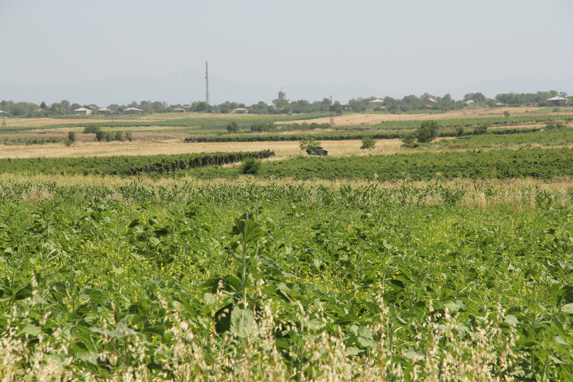
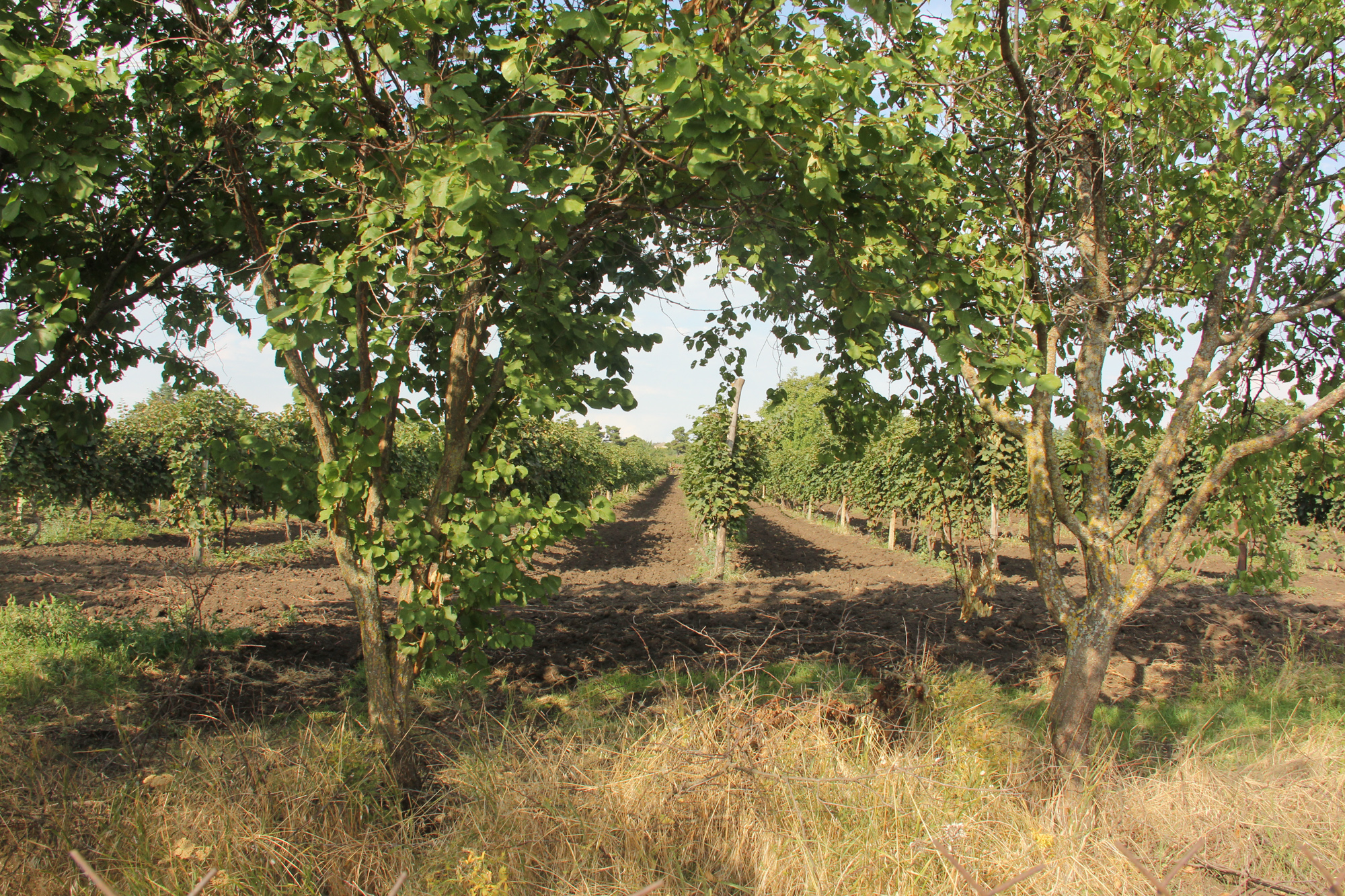
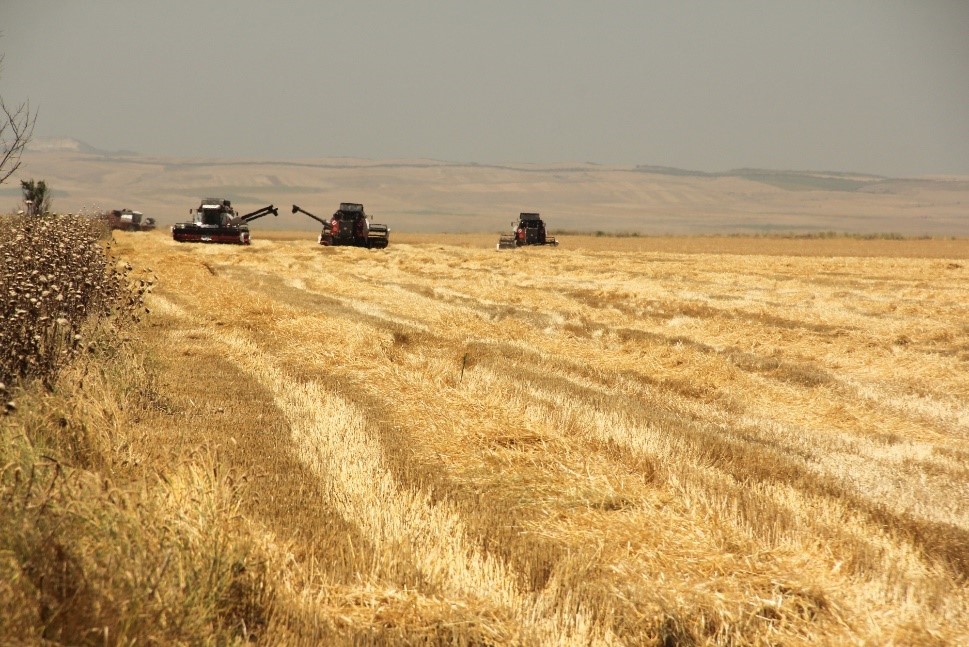
Unsustainable land use practices, such as deforestation, overgrazing and improper agricultural management systems are triggering the loss and degradation of valuable land resources in Georgia. Land use planning is one of the measures among others to contribute to support the integration of good Landscape and Sustainable Land Management (L-SLM) principles and practices into national policy and institutional framework to ensure the adoption of economically viable practices by rural communities. This technology is demonstrated in an application in Arkhiloskalo community in Eastern Georgia.
2.2 การอธิบายแบบละเอียดของเทคโนโลยี
คำอธิบาย:
The globally ongoing degradation of land resources is threatening our food security and functioning ecosystem services. Therefore, restoration of degraded land as defined by the Sustainable Development Goal (SDG 15.3) has become a strategic objective of the UNCCD. To achieve Land Degradation Neutrality (LDN), action on the national level is needed. Georgia is one of the 113 countries (as of Sept. 2017) willing to take part in the Target Setting Program (TSP).
One of the major problems which Georgia is facing today is an absence of a comprehensive and integrated approach in the land management sector. In addition, an irrelevant legal framework sometimes leads to additional “conflicts” with the evolved national strategy and policy packages.
The land-use planning in the village of Arkhiloskalo, Dedoplistskaro Municipality is one of the pilot activities linked to LDN (Land Degradation Neutrality). The project financed by Global Environment Facility (GEF) / UN Environment Programm (UNEP) was implemented by local partner REC Caucasus (The Regional Environmental Centre for the Caucasus) through E.C.O. Institute of Ecology (Austria).
The land-use plan documents the status quo of the current land use. It is a baseline that can be used to steer and monitor future developments. The land-use plan is based on field assessments made in summer 2019 and builds a baseline for future assessments/monitoring. The land-use plan on the village level helps to break down national LDN targets to the local level. The plan and the development of land-use scenarios help to anticipate the future gains and losses of land resources and reflect the national LDN-target on the local level. Local stakeholders can identify areas of degradation risk and areas which can be rehabilitated. The Arkhiloskalo land-use plan contributes to sustainable land use by recognizing the current situation of land use and its spatial distribution as well as identifying the strength and weaknesses of the current situation.
Methodology:
Mapping for Arkhiloskalo land use plan: The mapping result is a detailed documentation of size and spatial distribution of land cover categories. Change in land cover is an important indicator to monitor the loss and gains of land resources according to the LDN monitoring concept.
For the mapping of the settlements, arable land and gardens, maps from Google Earth and digital cadastre of parcels were used. In the field maps, each polygon has an assigned Map-ID number, which is unique for each village. Polygons with the same land use category and land-use intensity can have the same Map-ID. Next to the drawing of the polygon on the map, in a field form each polygon is described by:
- Map-ID;
- Current Land use category;
- Current Land-use intensity;
- Remark (a specification of the polygon if needed).
Classifications of land use categories: The land-use classification is based on the CLC - Corine Land Classification System (The CORINE Land Cover is a vector map with a scale of 1:10 000, a minimum cartographic unit (MCU) of 100 m². It maps homogeneous landscape patterns). The Corine Land Classification system classifies urban fabric, mine, dump and construction sites, arable land, permanent crops, pastures, forests, shrubs and herbaceous vegetation associations, Open spaces with little or no vegetation, inland wetlands and waters.
The pastureland was differentiated into different productivity classes. In the field three classes of vegetation cover and species composition: low, medium, and high productivity were assessed.
For the mapping in Arkhiloskalo the following land use categories were selected: Settlements and human infrastructure (Code from the Corine Land Classification system – e.g. SHR, name – e.g. Houses); Forests and shrub-land; Agricultural managed land; Natural and semi-natural habitats.
2.3 รูปภาพของเทคโนโลยี
อัลบั้มสื่อบันทึก
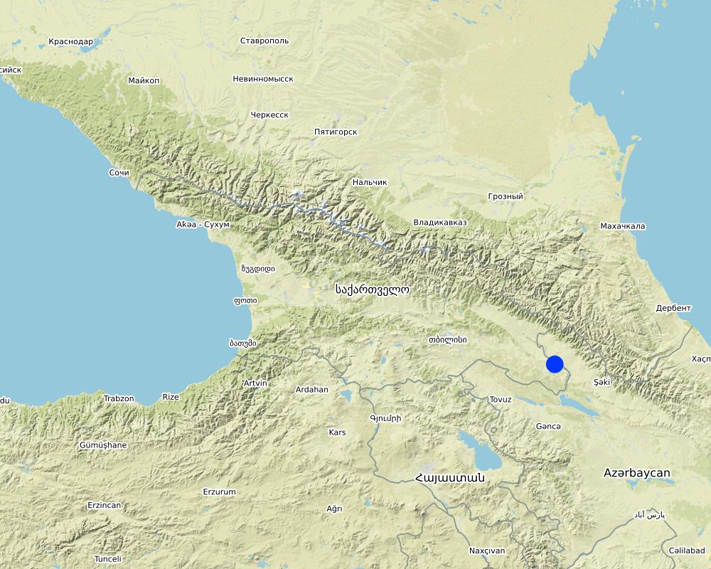
2.5 ประเทศภูมิภาค หรือสถานที่ตั้งที่เทคโนโลยีได้นำไปใช้และได้รับการครอบคลุมโดยการประเมินนี้
ประเทศ:
จอร์เจีย
ภูมิภาค/รัฐ/จังหวัด:
Kakheti
ข้อมูลจำเพาะเพิ่มเติมของสถานที่ตั้ง :
The Village of Arkhiloskalo is locted in the Municipality of Dedoplitskaro.
ระบุการกระจายตัวของเทคโนโลยี:
- กระจายไปอย่างสม่ำเสมอในพื้นที่
If the Technology is evenly spread over an area, specify area covered (in km2):
49.7
If precise area is not known, indicate approximate area covered:
- 10-100 ตร.กม.
แสดงความคิดเห็น:
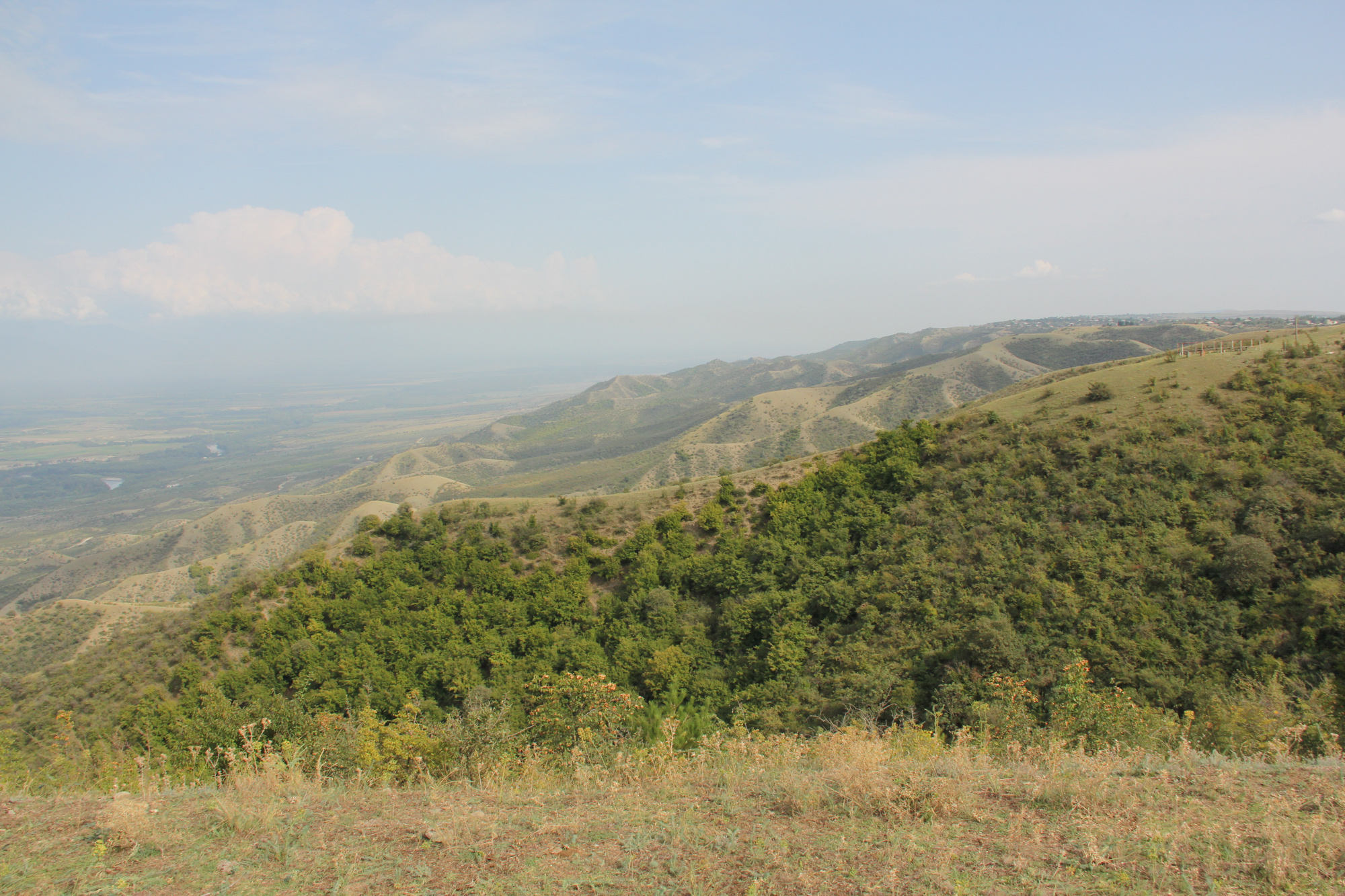
The village Arkhiloskalo covers an area of 4,970 ha. The area ranges from the lower section in the North 250 m (Alasani river valley) up to 730 m at the ridge and then falls again to the South in the Shiraki Valley to 600 m.
Map
×2.6 วันที่การดำเนินการ
ระบุปีที่ใช้:
2018
2.7 คำแนะนำของเทคโนโลยี
ให้ระบุว่าเทคโนโลยีถูกแนะนำเข้ามาอย่างไร:
- ทางโครงการหรือจากภายนอก
ความคิดเห็น (ประเภทของโครงการ เป็นต้น) :
The land-use plan approach is one of the measures among others to contribute to support the integration of good Landscape and Sustainable Land Management (L-SLM) principles and practices into national policy and institutional framework to ensure the adoption of economically viable practices by rural communities. This was a GEF-funded project.
3. การจัดประเภทของเทคโนโลยี SLM
3.1 วัตถุประสงค์หลักของเทคโนโลยี
- ปรับปรุงการผลิตให้ดีขึ้น
- ลด ป้องกัน ฟื้นฟู การเสื่อมโทรมของที่ดิน
- รักษาสภาพหรือปรับปรุงความหลากหลายทางชีวภาพ
- ปรับตัวเข้ากับการเปลี่ยนแปลงภูมิอากาศของโลก สภาพภูมิอากาศที่รุนแรงและผลกระทบ
- สร้างผลกระทบทางด้านเศรษฐกิจที่เป็นประโยชน์
3.2 ประเภทของการใช้ที่ดินในปัจจุบันที่ได้นำเทคโนโลยีไปใช้
Land use mixed within the same land unit:
ใช่
Specify mixed land use (crops/ grazing/ trees):
- วนเกษตร (Agroforestry)

พื้นที่ปลูกพืช
- การปลูกพืชล้มลุกอายุปีเดียว
- การปลูกไม้ยืนต้น ไม้พุ่ม
Annual cropping - Specify crops:
- cereals - wheat (spring)
- cereals - wheat (winter)
- oilseed crops - sunflower, rapeseed, other
Tree and shrub cropping - Specify crops:
- fruits, other
- grapes
จำนวนของฤดูเพาะปลูกต่อปี:
- 1
ระบุ:
summer
Is intercropping practiced?
ไม่ใช่
Is crop rotation practiced?
ไม่ใช่

ทุ่งหญ้าเลี้ยงสัตว์
Extensive grazing:
- การทำฟาร์มปศุสัตว์ (Ranching)
ทุ่งหญ้าเลี้ยงสัตว์ที่มีการจัดการแบบเข้มข้นหรือการผลิตอาหารสัตว์:
- ตัดแล้วขนไป / ไม่มีการปล่อยแทะเล็มเอง (Cut-and-carry / zero grazing)
- ทุ่งหญ้าเลี้ยงสัตว์ที่ได้มีการปรับปรุง (Improved pastures)
Animal type:
- cattle - dairy and beef (e.g. zebu)
Is integrated crop-livestock management practiced?
ไม่ใช่
Species:
cattle - dairy and beef (e.g. zebu)
Count:
982

การตั้งถิ่นฐาน โครงสร้างพื้นฐาน
- การตั้งถิ่นฐาน ตึกอาคาร
- การจราจร ทางถนน รถไฟ
แสดงความคิดเห็น:
All form of land cover and land use forms have been mapped.
3.3 Has land use changed due to the implementation of the Technology?
Has land use changed due to the implementation of the Technology?
- No (Continue with question 3.4)
3.4 การใช้น้ำ
การใช้น้ำของที่ดินที่มีการใช้เทคโนโลยีอยู่:
- จากน้ำฝน
3.5 กลุ่ม SLM ที่ตรงกับเทคโนโลยีนี้
- แนวกันลมหรือแนวต้านลม
- ระบบหมุนเวียน (การปลูกพืชหมุนเวียน การพักดิน การเกษตรแบบไร่เลื่อนลอย)
- การจัดการของเสีย / การจัดการน้ำเสีย
- Land use planning
3.6 มาตรการ SLM ที่ประกอบกันเป็นเทคโนโลยี

มาตรการอนุรักษ์ด้วยการจัดการ
- M2: การเปลี่ยนแปลงของการจัดการหรือระดับความเข้มข้น
- M7: อื่นๆ
แสดงความคิดเห็น:
The land use planning started with mapping of current land use and included stakeholders input on strength and weaknesses. Based on this, development scenarios have been developed to change current land use approaches to a more sustainable way (e.g. restoration of windbreaks, crop rotation etc.)
3.7 รูปแบบหลักของการเสื่อมโทรมของที่ดินที่ได้รับการแก้ไขโดยเทคโนโลยี

การกัดกร่อนของดินโดยลม
- Et (Loss of topsoil): การสูญเสียดินชั้นบน
แสดงความคิดเห็น:
The loss of windbreaks caused an increased exposure of topsoil to wind erosion on fields with annual crops. The land use plan helps to quantify the current state of the windbreaks and underlines their functional importance.
3.8 การป้องกัน การลดลง หรือการฟื้นฟูความเสื่อมโทรมของที่ดิน
ระบุเป้าหมายของเทคโนโลยีกับความเสื่อมโทรมของที่ดิน:
- ป้องกันความเสื่อมโทรมของที่ดิน
4. ข้อมูลจำเพาะด้านเทคนิค กิจกรรมการนำไปปฏิบัติใช้ ปัจจัยนำเข้า และค่าใช้จ่าย
4.1 แบบแปลนทางเทคนิคของเทคโนโลยี
ข้อมูลจำเพาะด้านเทคนิค (แบบแปลนทางเทคนิคของเทคโนโลยี):
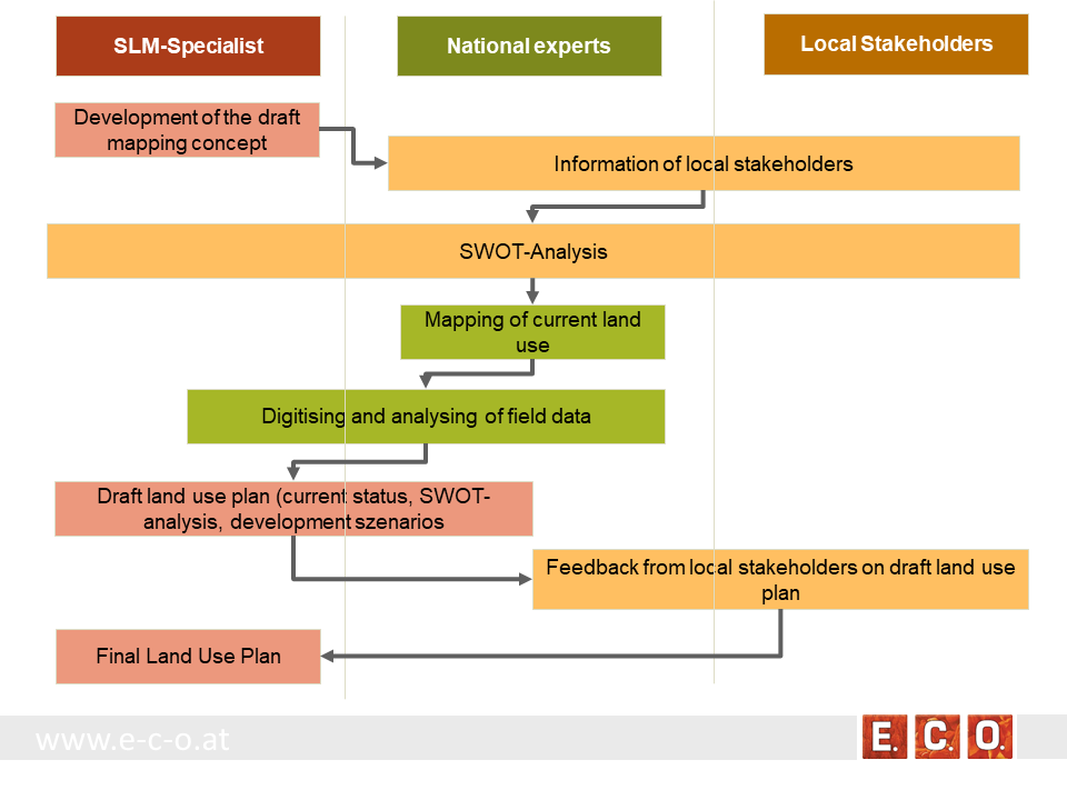
Key stages of implementation:
The land-use planning in the village of Arkhiloskalo, Dedoplistskaro Municipality is one of the pilot activities linked to LDN.
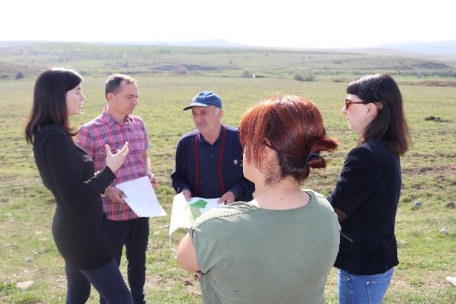
Together with the local stakeholders, a land-use plan has been worked out. The procedure of defining a spatial development plan for a municipality goes along three stages:
• Stage 1: Gather background information & implement pre-design studies and development of a mapping concept
• Stage 2: Information of local stakeholders on this activity and implementation of an SWOT analysis (Strength, Weaknesses, Opportunities, Threats) related to the land use of the village
• Stage 3: Mapping and analyzing the current land use
• Stage 4: Preparation of a draft land use plan
• Stage 5: Reflection of the draft land use plan with local stakeholders
• Stage 6: Preparation of the final land use plan
ผู้เขียน:
Hanns Kirchmeir
วันที่:
16/01/2020
ข้อมูลจำเพาะด้านเทคนิค (แบบแปลนทางเทคนิคของเทคโนโลยี):
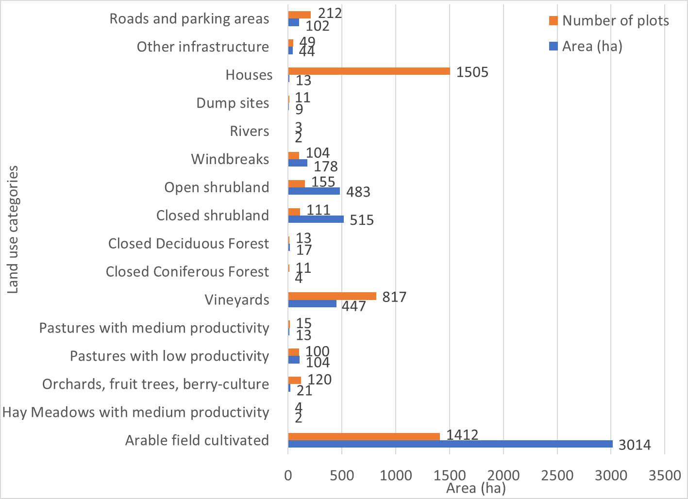
Absolute area sizes. The largest land use category is arable land (3,014 ha) followed by closed and open shrubland (515 ha and 483 ha, respectively). Vineyards cover a total of 447 ha whereas windbreaks cover 178 ha. Pastures with low productivity (104 ha) and roads and parking areas (102 ha) use almost the same amount of land. Other infrastructure covers 44 ha of land. Orchards, fruit trees and berry-culture use 21 ha of land. Closed deciduous forest (17 ha) covers only a few more hectares than pastures (13 ha). Houses are the most common plot category in Arkhiloskalo but use only around 13 ha of land which puts them on the same land-use level as pastures. Dumpsites (9 ha) use more than twice the area of closed coniferous forest (4 ha). Hay meadows and rivers cover around 2 ha of the area.
ผู้เขียน:
Hanns Kirchmeir
วันที่:
20/11/2019
ข้อมูลจำเพาะด้านเทคนิค (แบบแปลนทางเทคนิคของเทคโนโลยี):
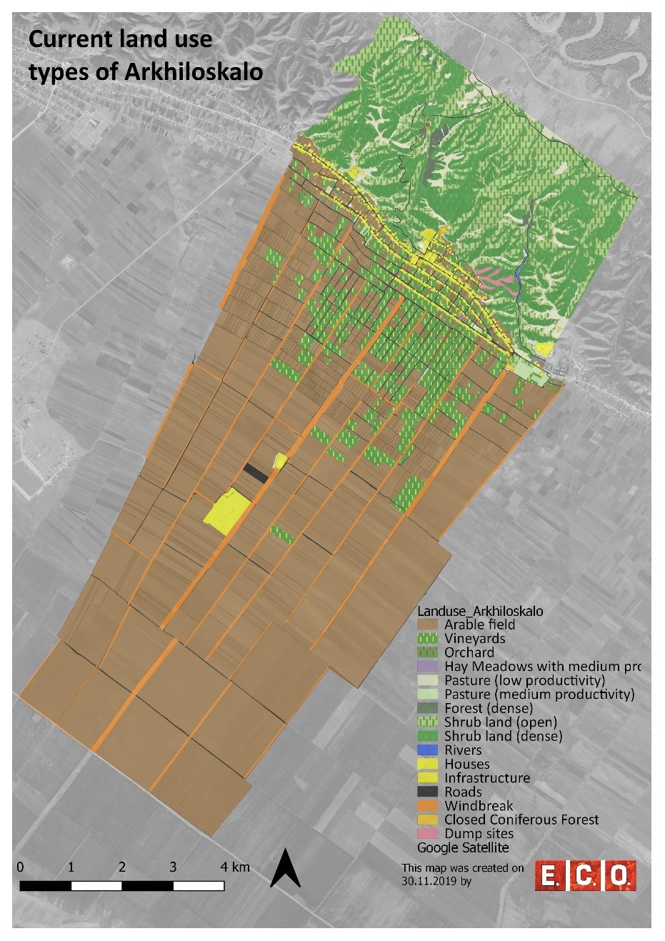
Map of current land-use categories in Arkhiloskalo. The land-use classification in this approach is based on the Corine Land Classification System. It was split into sub-categories where needed to meet the needs of local land use practices.
ผู้เขียน:
Hanns Kirchmeir
วันที่:
13/11/2019
ข้อมูลจำเพาะด้านเทคนิค (แบบแปลนทางเทคนิคของเทคโนโลยี):
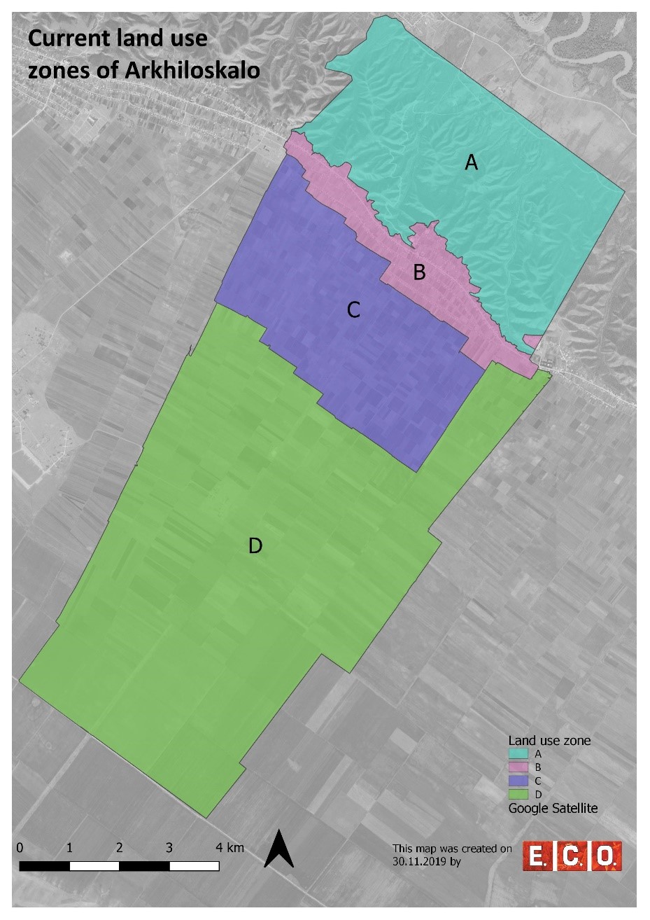
Based on the different land use, 4 different zones have been separated:
•Zone A: Steep North Slope
•Zone B. Settlement Area
•Zone C: Zone of perennial Crops
•Zone D: Zone of annual Crops
ผู้เขียน:
Hanns Kirchmeir
4.2 ข้อมูลทั่วไปเกี่ยวกับการคำนวณปัจจัยนำเข้าและค่าใช้จ่าย
ให้ระบุว่าค่าใช้จ่ายและปัจจัยนำเข้าได้รับการคำนวณอย่างไร:
- ต่อพื้นที่ที่ใช้เทคโนโลยี
ระบุขนาดและหน่วยพื้นที่:
50 km²
ระบุสกุลเงินที่ใช้คำนวณค่าใช้จ่าย:
- USD
ระบุค่าเฉลี่ยของค่าจ้างในการจ้างแรงงานต่อวัน:
national expert 100 USD
4.3 กิจกรรมเพื่อการจัดตั้ง
| กิจกรรม | Timing (season) | |
|---|---|---|
| 1. | Gather background information & implement pre-design studies and development of a mapping concept | Winter/spring |
| 2. | Information of local stakeholders on this activity and implementation of an SWOT analysis (Strength, Weaknesses, Opportunities, Threats) related to the land use of the village | Spring |
| 3. | Mapping and analyzing the current land use | Summer |
| 4. | Preparation of a draft land use plan | Autumn/Winter |
| 5. | Reflection of the draft land use plan with local stakeholders | Autumn/Winter |
| 6. | Preparation of the final land use plan | Autumn/Winter |
4.4 ค่าใช้จ่ายของปัจจัยนำเข้าที่จำเป็นสำหรับการจัดตั้ง
If you are unable to break down the costs in the table above, give an estimation of the total costs of establishing the Technology:
15000.0
ถ้าผู้ใช้ที่ดินรับภาระน้อยกว่า 100% ของค่าใช้จ่าย ให้ระบุว่าใครเป็นผู้รับผิดชอบส่วนที่เหลือ:
REC-Caucasus, GEF-funded Project
แสดงความคิดเห็น:
The budget is $ 15 000 / per year. This amount includes the salaries of following expert, such as: National expert on SLM, National expert on LUP, International expert on SLM, International expert on LUP, Botanist, GIS expert. Also the above budget includes travels and missions in three municipalities, workshops in Akhmeta and Dedoplistskaro municipalities, workshops and public hearings in selected local communities (Arkhiloskalo and Shenako),
4.7 ปัจจัยสำคัญที่สุดที่มีผลกระทบต่อค่าใช้จ่าย
ปัจจัยสำคัญที่สุดที่มีผลกระทบต่อค่าใช้จ่ายต่างๆ:
The field work of mapping and analysis of results took a lot of time as well as the stakeholder meetings.
5. สิ่งแวดล้อมทางธรรมชาติและของมนุษย์
5.1 ภูมิอากาศ
ฝนประจำปี
- < 250 ม.ม.
- 251-500 ม.ม.
- 501-750 ม.ม.
- 751-1,000 ม.ม.
- 1,001-1,500 ม.ม.
- 1,501-2,000 ม.ม.
- 2,001-3,000 ม.ม.
- 3,001-4,000 ม.ม.
- > 4,000 ม.ม.
ข้อมูลจำเพาะ/ความคิดเห็นเรื่องปริมาณน้ำฝน:
The driest month is January, with 25 mm of rainfall. The greatest amount of precipitation occurs in June, with an average of 108 mm. The difference in precipitation between the driest month and the wettest month is 83 mm.
ระบุชื่อของสถานีตรวดวัดอากาศที่ใช้อ้างอิงคือ:
Dedoplistskaro Met. Station
เขตภูมิอากาศเกษตร
- กึ่งแห้งแล้ง
The climate is warm and temperate in Dedoplistskaro. The average annual temperature in Dedoplistskaro is 11.3 °C. The warmest month of the year is July, with an average temperature of 22.7 °C. The lowest average temperatures in the year occur in January, when it is around 0.1 °C.
5.2 สภาพภูมิประเทศ
ค่าเฉลี่ยความลาดชัน:
- ราบเรียบ (0-2%)
- ลาดที่ไม่ชัน (3-5%)
- ปานกลาง (6-10%)
- เป็นลูกคลื่น (11-15%)
- เป็นเนิน (16-30%)
- ชัน (31-60%)
- ชันมาก (>60%)
ธรณีสัณฐาน:
- ที่ราบสูง/ที่ราบ
- สันเขา
- ไหล่เขา
- ไหล่เนินเขา
- ตีนเนิน
- หุบเขา
ระดับความสูง:
- 0-100 เมตร
- 101-500 เมตร
- 501-1,000 เมตร
- 1,001-1,500 เมตร
- 1,501-2,000 เมตร
- 2,001-2,500 เมตร
- 2,501-3,000 เมตร
- 3,001-4,000 เมตร
- > 4,000 เมตร
ให้ระบุถ้าเทคโนโลยีได้ถูกนำไปใช้:
- ไม่เกี่ยวข้อง
ความคิดเห็นและข้อมูลจำเพาะเพิ่มเติมเรื่องสภาพภูมิประเทศ:
The pastures are located on steep hill slope to the north, while the village and arable lands are located on the gently south facing terrace.
5.3 ดิน
ค่าเฉลี่ยความลึกของดิน:
- ตื้นมาก (0-20 ซ.ม.)
- ตื้น (21-50 ซ.ม.)
- ลึกปานกลาง (51-80 ซ.ม.)
- ลึก (81-120 ซ.ม.)
- ลึกมาก (>120 ซ.ม.)
เนื้อดิน (ดินชั้นบน):
- ปานกลาง (ดินร่วน ทรายแป้ง)
เนื้อดินล่าง (> 20 ซ.ม.ต่ำจากผิวดิน):
- ปานกลาง (ดินร่วน ทรายแป้ง)
อินทรียวัตถุในดิน:
- สูง (>3%)
5.4 ความเป็นประโยชน์และคุณภาพของน้ำ
ระดับน้ำใต้ดิน:
5-50 เมตร
น้ำไหลบ่าที่ผิวดิน:
ไม่ดีหรือไม่มีเลย
คุณภาพน้ำ (ที่ยังไม่ได้บำบัด):
เป็นน้ำเพื่อการดื่มที่ไม่ดี (จำเป็นต้องได้รับการบำบัด)
Water quality refers to:
ground water
ความเค็มของน้ำเป็นปัญหาหรือไม่:
ไม่ใช่
กำลังเกิดน้ำท่วมในพื้นที่หรือไม่:
ไม่ใช่
5.5 ความหลากหลายทางชีวภาพ
ความหลากหลายทางชนิดพันธุ์:
- สูง
ความหลากหลายของแหล่งที่อยู่:
- สูง
ความคิดเห็นและข้อมูลจำเพาะเพิ่มเติมของความหลากหลายทางชีวภาพ:
Especially the semi-natural landscapes of the slopes to the north are of high habitat and species diversity.
5.6 ลักษณะของผู้ใช้ที่ดินที่นำเทคโนโลยีไปปฏิบัติใช้
อยู่กับที่หรือเร่ร่อน:
- อยู่กับที่
แนวทางการตลาดของระบบการผลิต:
- mixed (subsistence/ commercial)
รายได้ที่มาจากนอกฟาร์ม:
- < 10% ของรายได้ทั้งหมด
ระดับของความมั่งคั่งโดยเปรียบเทียบ:
- จน
เป็นรายบุคคล/ครัวเรือน:
- เป็นรายบุคคล/ครัวเรือน
ระดับของการใช้เครื่องจักรกล:
- การใช้เครื่องจักรหรือเครื่องยนต์
เพศ:
- ชาย
อายุของผู้ใช้ที่ดิน:
- วัยกลางคน
ระบุลักษณะอื่นๆที่เกี่ยวข้องของผู้ใช้ที่ดิน:
The village is very remote. Driving distance to the municipality is about 1h on bad roads.
5.7 Average area of land used by land users applying the Technology
- < 0.5 เฮกตาร์
- 0.5-1 เฮกตาร์
- 1-2 เฮกตาร์
- 2-5 เฮกตาร์
- 5-15 เฮกตาร์
- 15-50 เฮกตาร์
- 50-100 เฮกตาร์
- 100-500 เฮกตาร์
- 500-1,000 เฮกตาร์
- 1,000-10,000 เฮกตาร์
- >10,000 เฮกตาร์
พิจารณาว่าเป็นขนาดเล็ก กลาง หรือขนาดใหญ่ (ซึ่งอ้างอิงถึงบริบทระดับท้องถิ่น):
- ขนาดกลาง
5.8 กรรมสิทธิ์ในที่ดิน สิทธิในการใช้ที่ดินและสิทธิในการใช้น้ำ
กรรมสิทธิ์ในที่ดิน:
- เป็นแบบชุมชนหรือหมู่บ้าน
- รายบุคคล ได้รับสิทธิครอบครอง
สิทธิในการใช้ที่ดิน:
- เข้าถึงได้แบบเปิด (ไม่ได้จัดระเบียบ)
- รายบุคคล
สิทธิในการใช้น้ำ:
- เกี่ยวกับชุมชน (ถูกจัดระเบียบ)
Are land use rights based on a traditional legal system?
ใช่
5.9 การเข้าถึงบริการและโครงสร้างพื้นฐาน
สุขภาพ:
- จน
- ปานกลาง
- ดี
การศึกษา:
- จน
- ปานกลาง
- ดี
ความช่วยเหลือทางด้านเทคนิค:
- จน
- ปานกลาง
- ดี
ตลาด:
- จน
- ปานกลาง
- ดี
พลังงาน:
- จน
- ปานกลาง
- ดี
ถนนและการขนส่ง:
- จน
- ปานกลาง
- ดี
น้ำดื่มและการสุขาภิบาล:
- จน
- ปานกลาง
- ดี
บริการด้านการเงิน:
- จน
- ปานกลาง
- ดี
6. ผลกระทบและสรุปคำบอกกล่าว
6.1 ผลกระทบในพื้นที่ดำเนินการ (On-site) จากการใช้เทคโนโลยี
ผลกระทบทางด้านเศรษฐกิจและสังคม
การผลิต
การผลิตพืชผล
แสดงความคิดเห็น/ระบุ:
Effects will be visible based on the implementation of selected development scenario provided by Land use plan.
ความหลากหลายของผลิตภัณฑ์
แสดงความคิดเห็น/ระบุ:
Effects will be visible based on the implementation of selected development scenario provided by Land use plan.
รายได้และค่าใช้จ่าย
ความหลากหลายของแหล่งผลิตรายได้
แสดงความคิดเห็น/ระบุ:
Effects will be visible based on the implementation of selected development scenario provided by Land use plan.
ผลกระทบด้านสังคมวัฒนธรรมอื่น ๆ
SLM หรือความรู้เรื่องความเสื่อมโทรมของที่ดิน
แสดงความคิดเห็น/ระบุ:
Improvements by training and workshops, awareness raising.
ผลกระทบด้านนิเวศวิทยา
ความหลากหลายทางชีวภาพของพืชและสัตว์
การปกคลุมด้วยพืช
แสดงความคิดเห็น/ระบุ:
Reduced grazing in zone A (north slope) will increase the vegetation cover. Effects will be visible based on the implementation of selected development scenario provided by Land use plan.
มวลชีวภาพ/เหนือดินชั้น C
แสดงความคิดเห็น/ระบุ:
Reduced grazing in zone A (north slope) will increase the cover of shrubs and trees which will lead to increase of biomass. Effects will be visible based on the implementation of selected development scenario provided by Land use plan.
ความหลากหลายทางชีวภาพของสัตว์
แสดงความคิดเห็น/ระบุ:
Effects will be visible based on the implementation of selected development scenario provided by Land use plan.
ความหลากหลายของสัตว์
แสดงความคิดเห็น/ระบุ:
Diversification of land use and restoration of windbreaks will increase habitat diversity. Effects will be visible based on the implementation of selected development scenario provided by Land use plan.
ลดความเสี่ยงของภัยพิบัติ
ความเร็วของลม
แสดงความคิดเห็น/ระบุ:
Improvement of windbreaks will reduce wind speed and topoil erosion. Effects will be visible based on the implementation of selected development scenario provided by Land use plan.
6.2 ผลกระทบนอกพื้นที่ดำเนินการ (Off-site) จากการใช้เทคโนโลยี
การเกิดมลพิษในน้ำบาดาลหรือแม่น้ำ
แสดงความคิดเห็น/ระบุ:
Removal of uncontrolled dump sites will reduce groundwater and river pollution especially in the Alasani floodplain north of the community.
ตะกอนที่ถูกพัดพามาโดยลม
แสดงความคิดเห็น/ระบุ:
The rehabilitation of windbreaks will have a positive impact on neighboring fields.
6.3 การเผชิญและความตอบสนองของเทคโนโลยีต่อการเปลี่ยนแปลงสภาพภูมิอากาศที่ค่อยเป็นค่อยไป และสภาพรุนแรงของภูมิอากาศ / ภัยพิบัติ (ที่รับรู้ได้โดยผู้ใช้ที่ดิน)
แสดงความคิดเห็น:
The technology of land use planning is not sensitive to climate change but is an appropriate technology to adapt land use to future anticipated climate changes.
6.4 การวิเคราะห์ค่าใช้จ่ายและผลประโยชน์ที่ได้รับ
ผลประโยชน์ที่ได้รับเปรียบเทียบกับค่าใช้จ่ายในการจัดตั้งเป็นอย่างไร (จากมุมมองของผู้ใช้ที่ดิน)
ผลตอบแทนระยะสั้น:
ด้านลบ
ผลตอบแทนระยะยาว:
ด้านบวก
ผลประโยชน์ที่ได้รับเปรียบเทียบกับค่าใช้จ่ายในการบำรุงรักษาหรือต้นทุนที่เกิดขึ้นซ้ำอีก เป็นอย่างไร (จากมุมมองของผู้ใช้ที่ดิน)
ผลตอบแทนระยะสั้น:
เป็นกลางหรือสมดุล
ผลตอบแทนระยะยาว:
เป็นกลางหรือสมดุล
แสดงความคิดเห็น:
The land use planning process is an investment in future developments. Return of investment can be expected in oncoming years. The mapping result is a detailed documentation of size and spatial distribution land cover categories. Change in land cover is an important indicator to monitor the loss and gains according to the LDN monitoring concept. The land-use plan is based on field assessments made in summer 2019 and built a baseline for future change assessments as it includes data on land-use intensity which will enable to consider change in time dynamics and to monitor changes on the ground.
6.5 การปรับตัวของเทคโนโลยี
- ครั้งเดียวหรือเป็นการทดลอง
ถ้ามีข้อมูลให้บอกปริมาณด้วย (จำนวนของครัวเรือนหรือครอบคลุมพื้นที่):
It was implemented as show case for one community
Of all those who have adopted the Technology, how many did so spontaneously, i.e. without receiving any material incentives/ payments?
- 0-10%
6.6 การปรับตัว
เทคโนโลยีได้รับการปรับเปลี่ยนเมื่อเร็วๆนี้ เพื่อให้ปรับตัวเข้ากับสภาพที่กำลังเปลี่ยนแปลงหรือไม่:
ไม่ใช่
6.7 จุดแข็ง / ข้อได้เปรียบ / โอกาสของเทคโนโลยี
| จุดแข็ง / ข้อได้เปรียบ / โอกาสในทัศนคติของผู้ใช้ที่ดิน |
|---|
| The majority of the land users in village Arkhiloskalo have been using the same land and natural resources through decades and have good understanding of the natural conditions and climate change perspectives of the target area. The land use plan, the scenario development and the knowledge exchange in the workshops are have been considered as advantage for awareness raising, joint decision making and to start a positive change in short-term period. |
| The successful land-use system with improved environment conditions and benefit to the local farmers can lead to be a perfect example for the whole municipality of Dedoplistskaro as most part of its territory is agricultural land in semi-arid environment facing some rapid and significant challenges caused by climate change. |
| จุดแข็ง / ข้อได้เปรียบ / โอกาสในทัศนคติของผู้รวบรวมหรือวิทยากรหลัก |
|---|
| The land use plan will help to optimize the management and to eliminate present challenges in the 4 separate zones and promote improved sustainable land- use, land-management practices like crop rotation and re-establishment of windbreaks. |
| The land-use plan helps to identify the strength, opportunities, weaknesses and threats and contribute to sustainable land-use and its management. E.g.: in the Zone A, Steep North Slope there is a high risk, that the waste in the dumpsites will be washed down in an uncontrolled manner into the natural and semi-natural habitats of the slope. The waste is partly burned and the wash out of toxic solute can harm nature and ground water. |
| Application of the technology helps to optimize management measures, which will reduce costs and labour forces, e.g., by increasing productivity of land and productivity of vineyards in the Zone C: zone of perennial crops. |
| The land-use map integrates climate mitigation. E.g. it helps to plan the re-establishment of the windbreaks, which significantly contributes to the reduction of wind erosion in the Zone D: Zone of annual crops. |
| The terrestrial evaluation of the current land use can also serve to evaluate remote sensing technologies for semi-automatic classification of land cover categories. |
6.8 จุดอ่อน / ข้อเสียเปรียบ / ความเสี่ยงของเทคโนโลยีและวิธีการแก้ไข
| จุดอ่อน / ข้อเสียเปรียบ / ความเสี่ยงในทัศนคติของผู้ใช้ที่ดิน | มีวิธีการแก้ไขได้อย่างไร |
|---|---|
| Lack of dialogue and trust could be one of the risks to succeed with the introduction of advanced methods of sustainable land management. | The proposed sustainable land-use practices and pilot activities should be planned in a way to have results on the ground in a short-term period to keep local farmers motivated. |
| จุดอ่อน / ข้อเสียเปรียบ / ความเสี่ยงในทัศนคติของผู้รวบรวมหรือวิทยากรหลัก | มีวิธีการแก้ไขได้อย่างไร |
|---|---|
| Risks: Land use plan Interest of farmers, guesthouse providers and local residents are conflicting. | This can be limited by good facilitation of focus group discussions between different stakeholder groups. |
| Local actors (farmers, guest house providers ...) are not interested in participating in the joint land-use planning process. | It will need a well-coordinated communication design to include all the local stakeholders in the process of practical and theoretical introduction to the principles of sustainable land-use. The communication should emphasize potential economic benefits to the local households together with advantages of the sustainability. This can be a key factor to get most of the local stakeholders engaged with the proposed sustainable land-use practices. |
7. การอ้างอิงและการเชื่อมต่อ
7.1 วิธีการและแหล่งข้อมูล
- ไปเยี่ยมชมภาคสนาม การสำรวจพื้นที่ภาคสนาม
2 days of joint field visit of the project team, 2 weeks of field-mapping of the national expert.
- การสัมภาษณ์กับผู้ใช้ที่ดิน
About 44 participants in workshops and 12 people interviewed.
- การสัมภาษณ์ผู้เชี่ยวชาญด้าน SLM หรือผู้ชำนาญ
2 specialists
- การเก็บรวบรวมมาจากรายงานและเอกสารที่มีอยู่
1 international expert and 3 national experts have been conducted for the feedback on the report.
วันที่เก็บรวบรวมข้อมูล(ภาคสนาม) :
12/08/2018
7.2 การอ้างอิงถึงสิ่งตีพิมพ์
หัวข้อ, ผู้เขียน, ปี, หมายเลข ISBN:
Pilot project on land degradation neutrality in Georgia: Final Report.2017.Huber, M., Joseph, A., Kirchmeir, H., Ghambashidze, G.
ชื่อเรื่อง ผู้เขียน ปี ISBN:
https://e-c-o.at/files/publications/downloads/D00813_ECO_policy_brief_LDN_Georgia_171025.pdf
หัวข้อ, ผู้เขียน, ปี, หมายเลข ISBN:
Applying Landscape and Sustainable Land Management (L-SLM) for mitigating land degradation and contributing to poverty reduction in rural areas: Final report. 2017. Kirchmeir, H., Joseph, A., Huber, M.
ชื่อเรื่อง ผู้เขียน ปี ISBN:
Request at RECC Caucasus
หัวข้อ, ผู้เขียน, ปี, หมายเลข ISBN:
limatologies at high resolution for the earth’s land surface areas. Sci. Data 4:170122 doi: 10.1038/sdata.2017. Karger, D. N. Conrad, O., Böhner, J., Kawohl, T., Kreft, H., Soria-Auza, R.W., Zimmermann, N.E., Linder H.P. & Kessler M.
ชื่อเรื่อง ผู้เขียน ปี ISBN:
https://www.nature.com/articles/sdata2017122
7.4 General comments
It was not easy to consider the land use planning either to be a technology or an approach. Finally, we submitted as an approach.
ลิงก์และโมดูล
ขยายทั้งหมด ย่อทั้งหมดลิงก์
Land Degradation Neutrality Transformative Projects and Programmes (LDN-TPP) … [จอร์เจีย]
In the framework of the project ‘Generating Economic and Environmental Benefits from Sustainable Land Management for Vulnerable Rural Communities of Georgia’, Land Degradation Neutrality Transformative Projects and Programmes (LDN-TPP) were developed to implement the LDN targets at municipal level. The approach defines the process to break down global and international …
- ผู้รวบรวม: Daniel Zollner
โมดูล
ไม่มีโมดูล