Community Land Use Planning in Arkhiloskalo [Гүрж ]
- Шинийг нээх:
- Шинэчлэх:
- Мэдээлэл цуглуулсан: Hanns Kirchmeir
- Редактор: Kety Tsereteli
- Хянагч: Rima Mekdaschi Studer
technologies_5762 - Гүрж
Бүлгүүдийг үзэх
Бүгдийг харуулах Бүгдийг хаах1. Ерөнхий мэдээлэл
1.2 Технологийг үнэлэх, баримтжуулах ажилд хамаарах мэдээлэл өгсөн хүмүүс, байгууллагуудын холбоо барих мэдээлэл
ГТМ мэргэжилтэн :
Технологи баримтжуулах/үнэлэх ажилд дэмжлэг үзүүлсэн төслийн нэр (шаардлагатай бол)
Applying Landscape and Sustainable Land Management (L-SLM) for mitigating land degradation and contributing to poverty reduction in rural area (L-SLM Project)Технологи баримтжуулах/үнэлэх ажилд дэмжлэг үзүүлсэн байгууллага(ууд)-ын нэр (шаардлагатай бол)
Regional Environmental Centre for the Caucasus (REC Caucasus) - Гүрж1.3 WOCAT-аар баримтжуулсан өгөгдлийг ашиглахтай холбоотой нөхцөл
Эмхэтгэгч болон гол мэдээлэгч хүн(хүмүүс) WOCAT аргачлалаар баримтжуулсан мэдээллийг ашиглахтай холбоотой нөхцлийг хүлээн зөвшөөрсөн.
Тийм
1.4 Технологи тогтвортой гэдгийг баталгаажуулах
Энэ технологи азрын доройтлыг бууруулахад нөлөө үзүүлэхгүй тул газрын тогтвортой менежментийн технологи болж чадахгүй юу?
Үгүй
1.5 ГТМ Арга барилын Асуулга (ууд) руу хандах (WOCAT ашиглан баримтжуулсан)
Land Degradation Neutrality Transformative Projects and Programmes (LDN-TPP) … [Гүрж ]
In the framework of the project ‘Generating Economic and Environmental Benefits from Sustainable Land Management for Vulnerable Rural Communities of Georgia’, Land Degradation Neutrality Transformative Projects and Programmes (LDN-TPP) were developed to implement the LDN targets at municipal level. The approach defines the process to break down global and international …
- Мэдээлэл цуглуулсан: Daniel Zollner
2. ГТМ Технологийн тодорхойлолт
2.1 Технологийн товч тодорхойлолт
Технологийн тодорхойлолт:
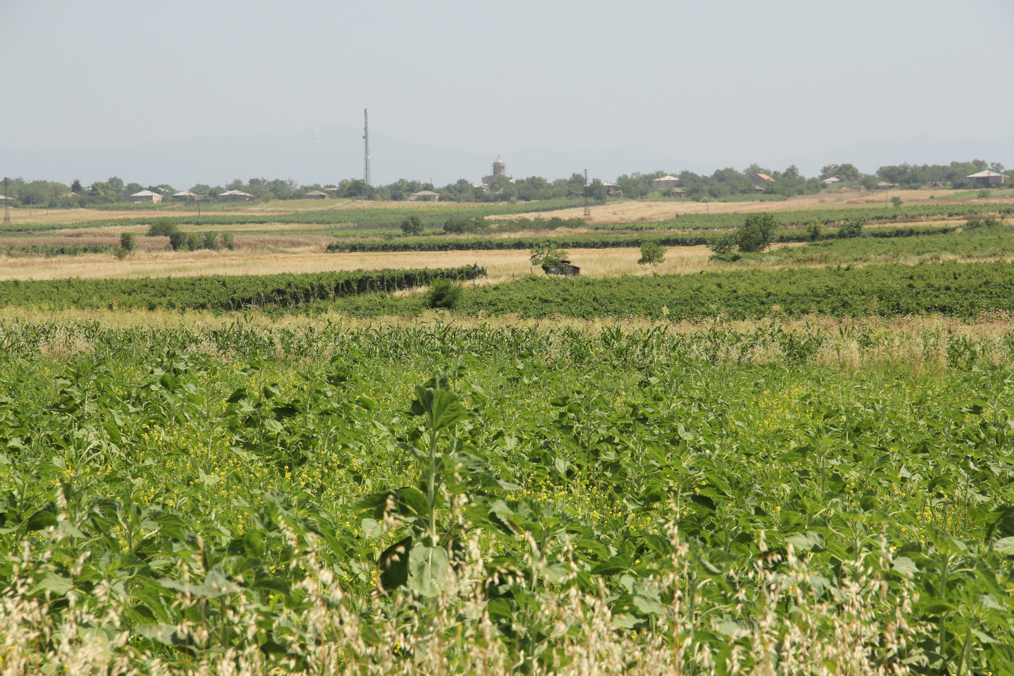
Unsustainable land use practices, such as deforestation, overgrazing and improper agricultural management systems are triggering the loss and degradation of valuable land resources in Georgia. Land use planning is one of the measures among others to contribute to support the integration of good Landscape and Sustainable Land Management (L-SLM) principles and practices into national policy and institutional framework to ensure the adoption of economically viable practices by rural communities. This technology is demonstrated in an application in Arkhiloskalo community in Eastern Georgia.
2.2 Технологийн дэлгэрэнгүй тайлбар
Тодорхойлолт:
The globally ongoing degradation of land resources is threatening our food security and functioning ecosystem services. Therefore, restoration of degraded land as defined by the Sustainable Development Goal (SDG 15.3) has become a strategic objective of the UNCCD. To achieve Land Degradation Neutrality (LDN), action on the national level is needed. Georgia is one of the 113 countries (as of Sept. 2017) willing to take part in the Target Setting Program (TSP).
One of the major problems which Georgia is facing today is an absence of a comprehensive and integrated approach in the land management sector. In addition, an irrelevant legal framework sometimes leads to additional “conflicts” with the evolved national strategy and policy packages.
The land-use planning in the village of Arkhiloskalo, Dedoplistskaro Municipality is one of the pilot activities linked to LDN (Land Degradation Neutrality). The project financed by Global Environment Facility (GEF) / UN Environment Programm (UNEP) was implemented by local partner REC Caucasus (The Regional Environmental Centre for the Caucasus) through E.C.O. Institute of Ecology (Austria).
The land-use plan documents the status quo of the current land use. It is a baseline that can be used to steer and monitor future developments. The land-use plan is based on field assessments made in summer 2019 and builds a baseline for future assessments/monitoring. The land-use plan on the village level helps to break down national LDN targets to the local level. The plan and the development of land-use scenarios help to anticipate the future gains and losses of land resources and reflect the national LDN-target on the local level. Local stakeholders can identify areas of degradation risk and areas which can be rehabilitated. The Arkhiloskalo land-use plan contributes to sustainable land use by recognizing the current situation of land use and its spatial distribution as well as identifying the strength and weaknesses of the current situation.
Methodology:
Mapping for Arkhiloskalo land use plan: The mapping result is a detailed documentation of size and spatial distribution of land cover categories. Change in land cover is an important indicator to monitor the loss and gains of land resources according to the LDN monitoring concept.
For the mapping of the settlements, arable land and gardens, maps from Google Earth and digital cadastre of parcels were used. In the field maps, each polygon has an assigned Map-ID number, which is unique for each village. Polygons with the same land use category and land-use intensity can have the same Map-ID. Next to the drawing of the polygon on the map, in a field form each polygon is described by:
- Map-ID;
- Current Land use category;
- Current Land-use intensity;
- Remark (a specification of the polygon if needed).
Classifications of land use categories: The land-use classification is based on the CLC - Corine Land Classification System (The CORINE Land Cover is a vector map with a scale of 1:10 000, a minimum cartographic unit (MCU) of 100 m². It maps homogeneous landscape patterns). The Corine Land Classification system classifies urban fabric, mine, dump and construction sites, arable land, permanent crops, pastures, forests, shrubs and herbaceous vegetation associations, Open spaces with little or no vegetation, inland wetlands and waters.
The pastureland was differentiated into different productivity classes. In the field three classes of vegetation cover and species composition: low, medium, and high productivity were assessed.
For the mapping in Arkhiloskalo the following land use categories were selected: Settlements and human infrastructure (Code from the Corine Land Classification system – e.g. SHR, name – e.g. Houses); Forests and shrub-land; Agricultural managed land; Natural and semi-natural habitats.
2.3 Технологийн гэрэл зураг
Медиа галерей
2.5 Энэ үнэлгээнд хамрагдсан технологийг хэрэгжүүлсэн улс орон / бүс нутаг / байршил
Улс :
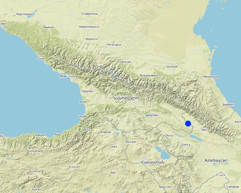
Гүрж
Улс/аймаг/сум:
Kakheti
Байршлын дэлгэрэнгүй тодорхойлолт:
The Village of Arkhiloskalo is locted in the Municipality of Dedoplitskaro.
Технологи өргөн дэлгэрсэн эсхийг тодорхойл:
- газар дээр жигд тархсан
Технологи газар нутгийн хэмжээнд жигд тархсан бол түүний эзлэх талбайг тодорхойлно уу (км2-аар):
49.7
Хэрэв талбайн хэмжээ тодорхойгүй бол талбайн хэмжээг ойролцоогоор тодорхойлно уу.
- 10-100 км2
Тайлбар:
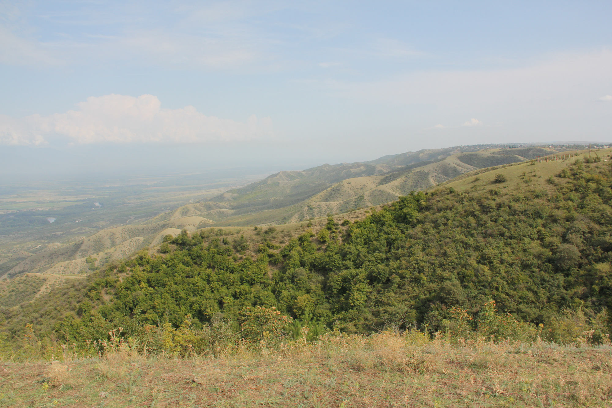
The village Arkhiloskalo covers an area of 4,970 ha. The area ranges from the lower section in the North 250 m (Alasani river valley) up to 730 m at the ridge and then falls again to the South in the Shiraki Valley to 600 m.
Map
×2.6 Хэрэгжих огноо
Хэрэгжүүлсэн он:
2018
2.7 Технологийн танилцуулга
Технологийг хэрхэн нэвтрүүлснийг тодорхойл:
- Гадны төсөл/хөтөлбөрийн дэмжлэгтэйгээр
Тайлбар (төслийн төрөл г.м.):
The land-use plan approach is one of the measures among others to contribute to support the integration of good Landscape and Sustainable Land Management (L-SLM) principles and practices into national policy and institutional framework to ensure the adoption of economically viable practices by rural communities. This was a GEF-funded project.
3. ГТМ технологийн ангилал
3.1 Технологийн үндсэн зорилго (д)
- Үйлдвэрлэлийг сайжруулах
- Газрын доройтлыг бууруулах, сэргийлэх, нөхөн сэргээх
- Биологийн төрөл зүйлийг хамгаалах / сайжруулах
- Уур амьсгалын өөрчлөлт/ эрс тэс байдал болон түүний нөлөөлөлд дасан зохицох
- Үр ашигтай эдийн засгийн нөлөөг бий болгох
3.2 Технологи хэвтрүүлсэн газрын одоогийн газар ашиглалтын хэлбэр(д)
Нэг газр нутгийн хэмжээнд хэрэгжих холимог газар ашиглалт:
Тийм
Газар ашиглалтын холимог тогтолцоог (тарилан/бэлчээр/ой мод) тодорхойл:
- ХАА-н ойжуулалт

Тариалангийн газар
- Нэг наст үр тариа
- Мод, бут тариалах
Тариалан - Таримлыг тодорхойлно уу:
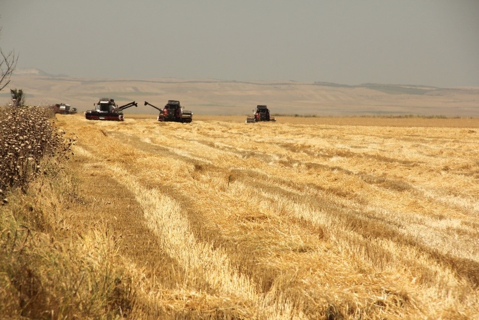
- үр тариа - улаан буудай (эрт ургацын)
- үр тариа - улаан буудай (өвлийн)
- тосны ургамал - наран цэцэг, рапс ба бусад
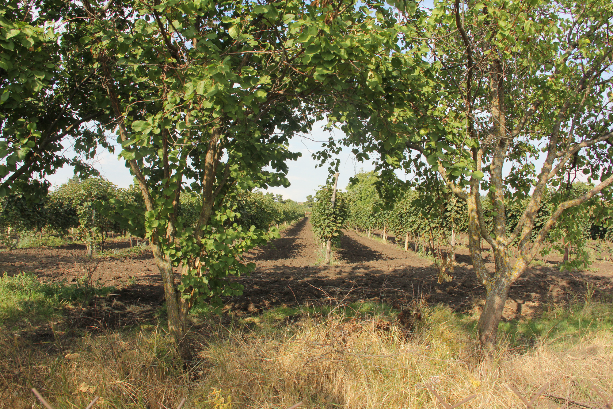
Мод, бут тариалах - Таримлыг тодорхойлно уу:
- жимс, бусад
- усан үзэм
Нэг жил дэх ургамал ургах улирлын тоо:
- 1
Тодорхойлно уу:
summer
Сөөлжлөн тариалалт хийгддэг үү?
Үгүй
Таримлыг ээлжлэн тариалдаг уу?
Үгүй

Бэлчээрийн газар
Нүүдлийн бэлчээр ашиглалт:
- Суурьшмал
Эрчимжсэн бэлчээр / тэжээл үйлдвэрлэл:
- Хадлан буюу бэлчээрт ашиглагдахгүй талбай
- Сайжруулсан бэлчээр
амьтдын төрөл зүйл:
- үхрийн аж ахуй - сүүний ба махны чиглэлийн (жишээ нь зебу)
Тариалан-мал аж ахуйн нэгдсэн менежмент хэрэгждэг үү?
Үгүй
Төрөл зүйл:
үхрийн аж ахуй - сүүний ба махны чиглэлийн (жишээ нь зебу)
Тоо хэмжээ:
982

Суурьшил, дэд бүтэц
- Хот суурин, барилга
- Замын хөдөлгөөн: авто зам, төмөр зам
Тайлбар:
All form of land cover and land use forms have been mapped.
3.3 Технологи хэрэгжүүлснээс газар ашиглалтад өөрчлөлт гарсан уу?
Технологи хэрэгжүүлснээс газар ашиглалтад өөрчлөлт гарсан уу?
- Үгүй (3.4 хариулт руу шилжинэ үү)
3.4 Усан хангамж
Технологи хэрэгжүүлсэн газрын усан хангамж:
- Байгалийн усалгаатай
3.5 Технологи ГТМ-ийн аль бүлэгт хамаарах
- Салхи / Хамгаалалтын ойн зурвас
- Эргэлтэт систем (газар тариалангийн эргэлт, уринш, ээлжлэн тариалалт)
- Хог хаягдлын менежмент / хаягдал усны менежмент
- Land use planning
3.6 Технологийг бүрдүүлэх ГТМ арга хэмжээ

Менежментийн арга хэмжээ
- М2: Ашиглалтын менежмент/эрчимийг өөрчлөх
- M7: Бусад
Тайлбар:
The land use planning started with mapping of current land use and included stakeholders input on strength and weaknesses. Based on this, development scenarios have been developed to change current land use approaches to a more sustainable way (e.g. restoration of windbreaks, crop rotation etc.)
3.7 Технологийн шийдвэрлэсэн газрын доройтлын үндсэн төрлүүд

Хөрс салхиар эвдрэх
- Et: Хөрсний гадаргын зөөгдөл
Тайлбар:
The loss of windbreaks caused an increased exposure of topsoil to wind erosion on fields with annual crops. The land use plan helps to quantify the current state of the windbreaks and underlines their functional importance.
3.8 Газрын доройтлоос урьдчилан сэргийлэх, сааруулах ба нөхөн сэргээх
Газрын доройтолтой холбоотойгоор Технологи ямар зорилго тавьсан болохыг тодорхойл:
- Газрын доройтлоос урьдчилан сэргийлэх
4. Техникийн нөхцөл, хэрэгжилтийн үйл ажиллагаа, материал ба зардал
4.1 Технологийн техникийн зураг
Техник тодорхойлолт (техник зурагтай уялдана):
Key stages of implementation:
The land-use planning in the village of Arkhiloskalo, Dedoplistskaro Municipality is one of the pilot activities linked to LDN.
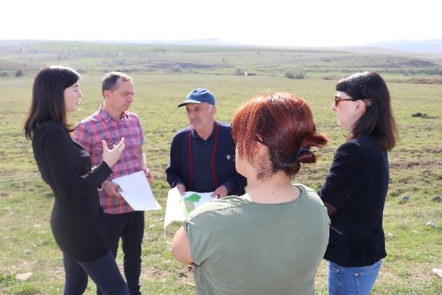
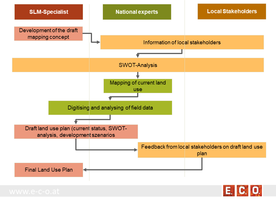
Together with the local stakeholders, a land-use plan has been worked out. The procedure of defining a spatial development plan for a municipality goes along three stages:
• Stage 1: Gather background information & implement pre-design studies and development of a mapping concept
• Stage 2: Information of local stakeholders on this activity and implementation of an SWOT analysis (Strength, Weaknesses, Opportunities, Threats) related to the land use of the village
• Stage 3: Mapping and analyzing the current land use
• Stage 4: Preparation of a draft land use plan
• Stage 5: Reflection of the draft land use plan with local stakeholders
• Stage 6: Preparation of the final land use plan
Зохиогч:
Hanns Kirchmeir
Он, сар, өдөр:
16/01/2020
Техник тодорхойлолт (техник зурагтай уялдана):
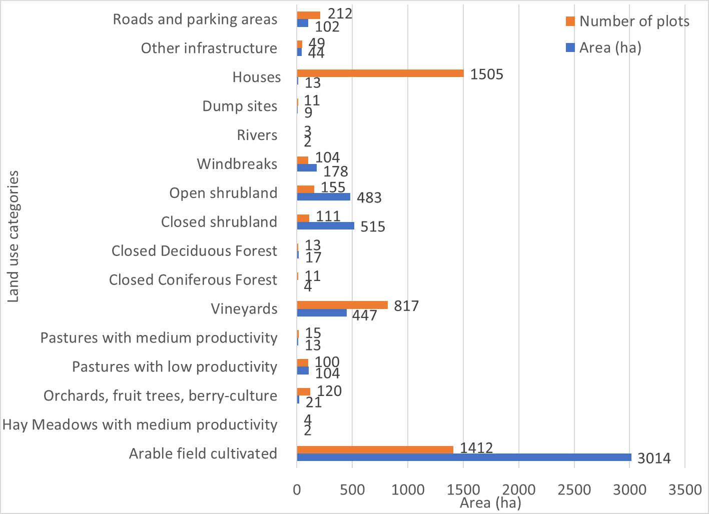
Absolute area sizes. The largest land use category is arable land (3,014 ha) followed by closed and open shrubland (515 ha and 483 ha, respectively). Vineyards cover a total of 447 ha whereas windbreaks cover 178 ha. Pastures with low productivity (104 ha) and roads and parking areas (102 ha) use almost the same amount of land. Other infrastructure covers 44 ha of land. Orchards, fruit trees and berry-culture use 21 ha of land. Closed deciduous forest (17 ha) covers only a few more hectares than pastures (13 ha). Houses are the most common plot category in Arkhiloskalo but use only around 13 ha of land which puts them on the same land-use level as pastures. Dumpsites (9 ha) use more than twice the area of closed coniferous forest (4 ha). Hay meadows and rivers cover around 2 ha of the area.
Зохиогч:
Hanns Kirchmeir
Он, сар, өдөр:
20/11/2019
Техник тодорхойлолт (техник зурагтай уялдана):
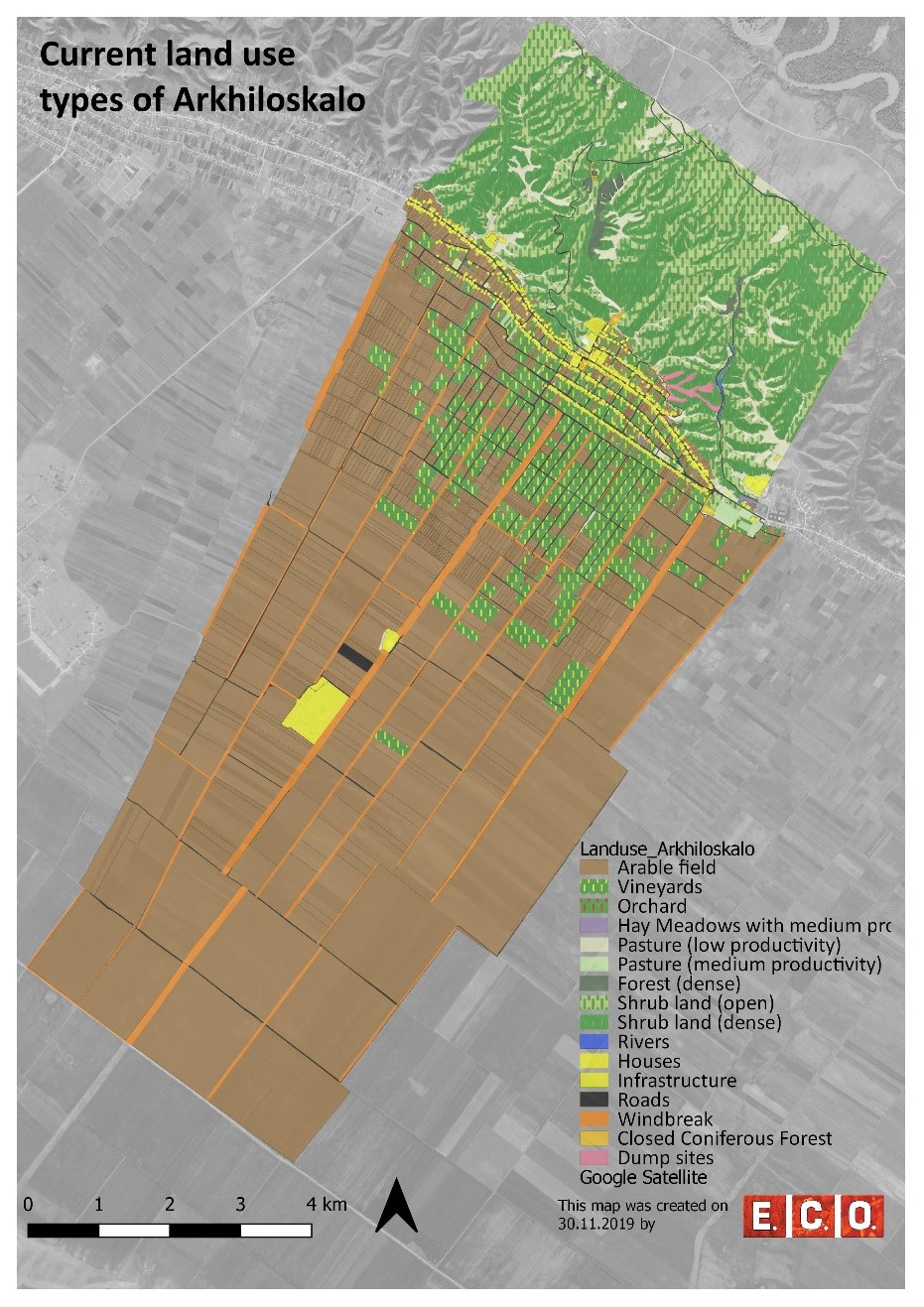
Map of current land-use categories in Arkhiloskalo. The land-use classification in this approach is based on the Corine Land Classification System. It was split into sub-categories where needed to meet the needs of local land use practices.
Зохиогч:
Hanns Kirchmeir
Он, сар, өдөр:
13/11/2019
Техник тодорхойлолт (техник зурагтай уялдана):
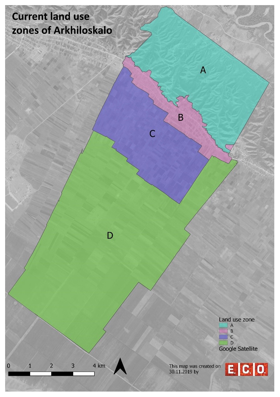
Based on the different land use, 4 different zones have been separated:
•Zone A: Steep North Slope
•Zone B. Settlement Area
•Zone C: Zone of perennial Crops
•Zone D: Zone of annual Crops
Зохиогч:
Hanns Kirchmeir
4.2 Материал болон зардалд хамаарах ерөнхий мэдээлэл
Үнэ өртөг, оруулсан хувь нэмрийг хэрхэн тооцсоныг тодорхойл:
- Технологийн нэгж тус бүр
Хэмжээ ба нэгж талбайг тодорхойл:
50 km²
Үнэ өртөгийг тооцоход ашигласан мөнгөн нэгж:
- Ам.доллар
Хөлсний ажилчны нэг өрдийн ажлын хөлсийг тодорхойл:
national expert 100 USD
4.3 Байгуулах үйл ажиллагаа
| Үйл ажиллагаа | Хугацаа (улирал) | |
|---|---|---|
| 1. | Gather background information & implement pre-design studies and development of a mapping concept | Winter/spring |
| 2. | Information of local stakeholders on this activity and implementation of an SWOT analysis (Strength, Weaknesses, Opportunities, Threats) related to the land use of the village | Spring |
| 3. | Mapping and analyzing the current land use | Summer |
| 4. | Preparation of a draft land use plan | Autumn/Winter |
| 5. | Reflection of the draft land use plan with local stakeholders | Autumn/Winter |
| 6. | Preparation of the final land use plan | Autumn/Winter |
4.4 Байгуулалтад шаардагдах зардал ба материал
Дээрхи хүснэгт дэх зардлын задаргааг гаргах боломжгүй бол Технологи бий болгоход зарцуулсан нийт зардлыг баримжаална уу.
15000.0
Хэрэв газар ашиглагчаас нийт өртөгийн 100%хүрэхгүй зардал гарсан бол хэн үлдсэн хөрөнгө оруулалтыг хийснийг тодорхойл.
REC-Caucasus, GEF-funded Project
Тайлбар:
The budget is $ 15 000 / per year. This amount includes the salaries of following expert, such as: National expert on SLM, National expert on LUP, International expert on SLM, International expert on LUP, Botanist, GIS expert. Also the above budget includes travels and missions in three municipalities, workshops in Akhmeta and Dedoplistskaro municipalities, workshops and public hearings in selected local communities (Arkhiloskalo and Shenako),
4.7 Зардалд нөлөөлж байгаа хамгийн чухал хүчин зүйл
Өртөг зардлыг тодорхойлох гол хүчин зүйлсийг дурьдана уу:
The field work of mapping and analysis of results took a lot of time as well as the stakeholder meetings.
5. Хүн, байгалийн хүрээлэн буй орчин
5.1 Уур амьсгал
Жилийн нийлбэр хур тундас
- <250 мм
- 251-500 мм
- 501-750 мм
- 751-1,000 мм
- 1,001-1,500 мм
- 1,501-2,000 мм
- 2,001-3,000 мм
- 3,001-4,000 мм
- > 4,000 мм
Хур тунадасны талаархи тодорхойлолт/ тайлбар:
The driest month is January, with 25 mm of rainfall. The greatest amount of precipitation occurs in June, with an average of 108 mm. The difference in precipitation between the driest month and the wettest month is 83 mm.
Суурь болгон авсан цаг уурын станцын нэр:
Dedoplistskaro Met. Station
Агро-уур амьсгалын бүс
- Хагас хуурай
The climate is warm and temperate in Dedoplistskaro. The average annual temperature in Dedoplistskaro is 11.3 °C. The warmest month of the year is July, with an average temperature of 22.7 °C. The lowest average temperatures in the year occur in January, when it is around 0.1 °C.
5.2 Байрзүйн зураг
Дундаж налуу:
- Тэгш (0-2 %)
- Бага зэрэг хэвгий (3-5 %)
- Дунд зэрэг хэвгий (6-10 % )
- Долгиорхог (11-15 %)
- Толгодорхог (16-30 %)
- Эгц налуу (31-60 % )
- Огцом эгц налуу (>60 %)
Гадаргын хэлбэр:
- Тэгш өндөрлөг/тэгш тал
- Зоо, хяр
- Уулын энгэр, хажуу
- Ухаа, гүвээ, дов толгод
- Уулын бэл
- Хөндий, хоолой, нам хотос
Өндөршлийн бүс:
- 0-100 м д.т.д
- 101-500 м д.т.д
- 501-1,000 м д.т.д
- 1,001-1,500 м д.т.д
- 1,501-2,000 м д.т.д
- 2,001-2,500 м д.т.д
- 2,501-3,000 м д.т.д
- 3,001-4,000 м д.т.д
- > 4,000 м д.т.д
Технологи дараах асуудалд хандсан эсэхийг тодорхойл:
- шаардлагагүй
Гадаргын талаархи тайлбар ба бусад тодорхойлолт:
The pastures are located on steep hill slope to the north, while the village and arable lands are located on the gently south facing terrace.
5.3 Хөрс
Хөрсний дундаж зузаан:
- Маш нимгэн (0-20 см)
- Нимгэн (21-50 см)
- Дунд зэрэг зузаан (51-80 см)
- Зузаан (81-120 cм)
- Маш зузаан (>120 cм)
Хөрсний бүтэц (өнгөн хөрс):
- Дунд зэрэг (шавранцар)
Хөрсний бүтэц (>20 см-ээс доош):
- Дунд зэрэг (шавранцар)
Өнгөн хөрсний органик нэгдэл:
- Их (>3 %)
5.4 Усны хүртээм ба чанар
Хөрсний усны гүн:
5-50 м
Гадаргын усны хүртээмж:
Муу/огт байхгүй
Усны чанар (цэвэрлээгүй):
Муу чанарын ундны ус (цэвэршүүлэх шаардлагатай)
Усны чанар гэж:
ул хөрсний ус
Усны давсжилт асуудал болдог уу?
Үгүй
Энэ газар үер усанд автдаг уу?
Үгүй
5.5 Биологийн төрөл зүйл
Зүйлийн олон янз байдал:
- Их
Амьдрах орчны олон янз байдал:
- Их
Биологийн олон янз байдлын талаархи тайлбар ба бусад тодорхойлолт:
Especially the semi-natural landscapes of the slopes to the north are of high habitat and species diversity.
5.6 Технологи нэвтрүүлсэн газар ашиглагчидын онцлог шинж
Суурьшмал эсвэл нүүдлийн:
- Суурьшмал
Үйлдвэрлэлийн системийн зах зээлийн чиг баримжаа:
- холимог (амьжиргаа ба худалдаанд)
Фермээс гадуурх орлого:
- Нийт орлогын %10 доош хувь
Чинээлэг байдлыг харьцангуй түвшин:
- Ядуу
Хувь хүн эсвэл бүлэг:
- Хувь хүн / өрх
Механикжилтын түвшин:
- Механикжсан / мотортой
Хүйс:
- Эрэгтэй
Газар ашиглагчийн нас:
- Дунд нас
Газар ашиглагчдын бусад шаардлагатай шинж чанарыг тодорхойл:
The village is very remote. Driving distance to the municipality is about 1h on bad roads.
5.7 Технологи нэвтрүүлэхэд газар ашиглагчийн ашигласан газрын дундаж талбай
- < 0.5 га
- 0.5-1 га
- 1-2 га
- 2-5 га
- 5-15 га
- 15-50 га
- 50-100 га
- 100-500 га
- 500-1,000 га
- 1,000-10,000 га
- > 10,000 га
Энэ нь жижиг, дунд, том оворт тооцогдох уу (орон нутгийн чиг баримжаагаар)?
- Дунд-хэмжээний
5.8 Газар эзэмшил, газар ашиглах эрх, ус ашиглах эрх
Газар өмчлөл:
- Нэгдэл/ тосгон
- Хувь хүн, цол эргэм бүхий
Газар ашиглах эрх:
- Нээлттэй хүртэх (зохион байгуулалтгүй)
- Хувь хүн
Ус ашиглах эрх:
- Нэгдлийн хэлбэрээр (зохион байгуулалттай)
Газар ашиглалтын эрх уламжлалт эрхзүйн тогтолцоонд суурилдаг уу?
Тийм
5.9 Дэд бүтэц, үйлчилгээний хүртээмж
эрүүл мэнд:
- Ядуу
- Дунд зэргийн
- Сайн
боловсрол:
- Ядуу
- Дунд зэргийн
- Сайн
техник дэмжлэг:
- Ядуу
- Дунд зэргийн
- Сайн
зах зээл:
- Ядуу
- Дунд зэргийн
- Сайн
эрчим хүч:
- Ядуу
- Дунд зэргийн
- Сайн
зам ба тээвэр:
- Ядуу
- Дунд зэргийн
- Сайн
ундны ус ба ариутгал:
- Ядуу
- Дунд зэргийн
- Сайн
санхүүгийн үйлчилгээ:
- Ядуу
- Дунд зэргийн
- Сайн
6. Үр нөлөө ба дүгнэлт
6.1 Технологийн талбай дахь үр нөлөө
Нийгэм-эдийн засгийн үр нөлөө
Үйлдвэрлэл
Газар тариалангийн үйлдвэрлэл
Тайлбар/ тодорхой дурьдах:
Effects will be visible based on the implementation of selected development scenario provided by Land use plan.
олон янз бүтээгдэхүүн
Тайлбар/ тодорхой дурьдах:
Effects will be visible based on the implementation of selected development scenario provided by Land use plan.
Орлого, зарлага
орлогын олон янз эх үүсвэр
Тайлбар/ тодорхой дурьдах:
Effects will be visible based on the implementation of selected development scenario provided by Land use plan.
Нийгэм-соёлын үр нөлөө
ГТМ/ газрын доройтлын талаархи мэдлэг
Тайлбар/ тодорхой дурьдах:
Improvements by training and workshops, awareness raising.
Экологийн үр нөлөө
Биологийн: ургамал, амьтан
Ургамал бүрхэвч
Тайлбар/ тодорхой дурьдах:
Reduced grazing in zone A (north slope) will increase the vegetation cover. Effects will be visible based on the implementation of selected development scenario provided by Land use plan.
газрын дээрхи / доорхи С
Тайлбар/ тодорхой дурьдах:
Reduced grazing in zone A (north slope) will increase the cover of shrubs and trees which will lead to increase of biomass. Effects will be visible based on the implementation of selected development scenario provided by Land use plan.
амьтны төрөл, зүйл
Тайлбар/ тодорхой дурьдах:
Effects will be visible based on the implementation of selected development scenario provided by Land use plan.
амьдрах орчны олон янз байдал
Тайлбар/ тодорхой дурьдах:
Diversification of land use and restoration of windbreaks will increase habitat diversity. Effects will be visible based on the implementation of selected development scenario provided by Land use plan.
Уур амьсгал болон гамшгийн эрсдлийг бууруулах
салхины хурд
Тайлбар/ тодорхой дурьдах:
Improvement of windbreaks will reduce wind speed and topoil erosion. Effects will be visible based on the implementation of selected development scenario provided by Land use plan.
6.2 Технологийн талбайн гадна үзүүлсэн үр нөлөө
газар доорхи ус/голын усны бохирдол
Тайлбар/ тодорхой дурьдах:
Removal of uncontrolled dump sites will reduce groundwater and river pollution especially in the Alasani floodplain north of the community.
салхиар тээвэрлэгдэх хурдас
Тайлбар/ тодорхой дурьдах:
The rehabilitation of windbreaks will have a positive impact on neighboring fields.
6.3 Технологийн уур амьсгалын өөрчлөлт ба Уур амьсгалаас хамаарах аюул/гамшигт үзэгдэлд өртөх байдал ба эмзэг байдал (газар ашиглагч нарын дүгнэлтээр)
Тайлбар:
The technology of land use planning is not sensitive to climate change but is an appropriate technology to adapt land use to future anticipated climate changes.
6.4 Зардал ба үр ашгийн шинжилгээ
Үр ашгийг барилга байгууламжийн зардалтай (газар ашиглагчдын үзэл бодлоор) хэрхэн харьцуулах вэ?
Богино хугацаанд эргэн төлөгдөх байдал:
Сөрөг
Урт хугацаанд эргэн төлөгдөх байдал:
Эерэг
Үр ашгийг засвар үйлчилгээ/ урсгал зардалтай (газар ашиглагчдын үзэл бодлоор) хэрхэн харьцуулах вэ?
Богино хугацаанд эргэн төлөгдөх байдал:
Дунд зэрэг
Урт хугацаанд эргэн төлөгдөх байдал:
Дунд зэрэг
Тайлбар:
The land use planning process is an investment in future developments. Return of investment can be expected in oncoming years. The mapping result is a detailed documentation of size and spatial distribution land cover categories. Change in land cover is an important indicator to monitor the loss and gains according to the LDN monitoring concept. The land-use plan is based on field assessments made in summer 2019 and built a baseline for future change assessments as it includes data on land-use intensity which will enable to consider change in time dynamics and to monitor changes on the ground.
6.5 Технологи нутагшуулах
- жишээ/ туршилт
Боломжтой бол, тоогоор илэрхийл (өрхийн тоо эсвэл бүрхэх талбай):
It was implemented as show case for one community
Технологийг өөрийн талбайд нэвтрүүлсэн бусад иргэдээс хэд нь үүнийг өөрийн хүчээр, өөрөөр хэлбэл ямар нэг материал, техникийн дэмжлэг, төлбөр авалгүй хийсэн бэ?
- 0-10%
6.6 Дасан зохицох
Хувьсан өөрчлөгдөж буй нөхцөл байдалд Технологид сүүлд ямар нэг шинэчлэл хийгдсэн үү?
Үгүй
6.7 Технологийн давуу тал/боломжууд
| Газар ашиглагчдын тодорхойлсон давуу тал/боломжууд |
|---|
| The majority of the land users in village Arkhiloskalo have been using the same land and natural resources through decades and have good understanding of the natural conditions and climate change perspectives of the target area. The land use plan, the scenario development and the knowledge exchange in the workshops are have been considered as advantage for awareness raising, joint decision making and to start a positive change in short-term period. |
| The successful land-use system with improved environment conditions and benefit to the local farmers can lead to be a perfect example for the whole municipality of Dedoplistskaro as most part of its territory is agricultural land in semi-arid environment facing some rapid and significant challenges caused by climate change. |
| Эмхэтгэгч, бусад мэдээлэл өгсөн хүмүүсийн өнцгөөс тодорхойлсон давуу тал/боломжууд |
|---|
| The land use plan will help to optimize the management and to eliminate present challenges in the 4 separate zones and promote improved sustainable land- use, land-management practices like crop rotation and re-establishment of windbreaks. |
| The land-use plan helps to identify the strength, opportunities, weaknesses and threats and contribute to sustainable land-use and its management. E.g.: in the Zone A, Steep North Slope there is a high risk, that the waste in the dumpsites will be washed down in an uncontrolled manner into the natural and semi-natural habitats of the slope. The waste is partly burned and the wash out of toxic solute can harm nature and ground water. |
| Application of the technology helps to optimize management measures, which will reduce costs and labour forces, e.g., by increasing productivity of land and productivity of vineyards in the Zone C: zone of perennial crops. |
| The land-use map integrates climate mitigation. E.g. it helps to plan the re-establishment of the windbreaks, which significantly contributes to the reduction of wind erosion in the Zone D: Zone of annual crops. |
| The terrestrial evaluation of the current land use can also serve to evaluate remote sensing technologies for semi-automatic classification of land cover categories. |
6.8 Технологийн дутагдалтай/сул тал/аюул болон тэдгээрийн хэрхэн даван туулах арга замууд
| Газар ашиглагч нарын тодорхойлсон сул тал/ дутагдал/ эрсдэл | Тэдгээрийг хэрхэн даван туулах вэ? |
|---|---|
| Lack of dialogue and trust could be one of the risks to succeed with the introduction of advanced methods of sustainable land management. | The proposed sustainable land-use practices and pilot activities should be planned in a way to have results on the ground in a short-term period to keep local farmers motivated. |
| Эмхэтгэгч, бусад мэдээлэл өгсөн хүмүүсийн өнцгөөс тодорхойлсон сул тал/ дутагдал/ эрсдэл | Тэдгээрийг хэрхэн даван туулах вэ? |
|---|---|
| Risks: Land use plan Interest of farmers, guesthouse providers and local residents are conflicting. | This can be limited by good facilitation of focus group discussions between different stakeholder groups. |
| Local actors (farmers, guest house providers ...) are not interested in participating in the joint land-use planning process. | It will need a well-coordinated communication design to include all the local stakeholders in the process of practical and theoretical introduction to the principles of sustainable land-use. The communication should emphasize potential economic benefits to the local households together with advantages of the sustainability. This can be a key factor to get most of the local stakeholders engaged with the proposed sustainable land-use practices. |
7. Ном зүй ба холбоосууд
7.1 Мэдээллийн аргууд / эх сурвалжууд
- Хээрийн уулзалт, судалгаа
2 days of joint field visit of the project team, 2 weeks of field-mapping of the national expert.
- Газар ашиглагчтай хийсэн ярилцлага
About 44 participants in workshops and 12 people interviewed.
- ГТМ-ийн мэргэжилтэн/шинжээчтэй хийсэн ярилцлага
2 specialists
- тайлан болон бусад эх сурвалжийн бүрдэл
1 international expert and 3 national experts have been conducted for the feedback on the report.
Мэдээллийг хэзээ (газар дээр нь) цуглуулсан бэ?
12/08/2018
7.2 Хүртээмжтэй ном, бүтээлийн ишлэл
Гарчиг, зохиогч, он, ISBN:
Pilot project on land degradation neutrality in Georgia: Final Report.2017.Huber, M., Joseph, A., Kirchmeir, H., Ghambashidze, G.
Хаанаас авч болох вэ? Зардал?
https://e-c-o.at/files/publications/downloads/D00813_ECO_policy_brief_LDN_Georgia_171025.pdf
Гарчиг, зохиогч, он, ISBN:
Applying Landscape and Sustainable Land Management (L-SLM) for mitigating land degradation and contributing to poverty reduction in rural areas: Final report. 2017. Kirchmeir, H., Joseph, A., Huber, M.
Хаанаас авч болох вэ? Зардал?
Request at RECC Caucasus
Гарчиг, зохиогч, он, ISBN:
limatologies at high resolution for the earth’s land surface areas. Sci. Data 4:170122 doi: 10.1038/sdata.2017. Karger, D. N. Conrad, O., Böhner, J., Kawohl, T., Kreft, H., Soria-Auza, R.W., Zimmermann, N.E., Linder H.P. & Kessler M.
Хаанаас авч болох вэ? Зардал?
https://www.nature.com/articles/sdata2017122
7.4 Ерөнхий мэдээлэл
It was not easy to consider the land use planning either to be a technology or an approach. Finally, we submitted as an approach.
Холбоос ба модулууд
Бүгдийг харуулах Бүгдийг хаахХолбоосууд
Land Degradation Neutrality Transformative Projects and Programmes (LDN-TPP) … [Гүрж ]
In the framework of the project ‘Generating Economic and Environmental Benefits from Sustainable Land Management for Vulnerable Rural Communities of Georgia’, Land Degradation Neutrality Transformative Projects and Programmes (LDN-TPP) were developed to implement the LDN targets at municipal level. The approach defines the process to break down global and international …
- Мэдээлэл цуглуулсан: Daniel Zollner
Модулууд
Модуль байхгүй байна