Community Land Use Planning in Arkhiloskalo [乔治亚]
- 创建:
- 更新:
- 编制者: Hanns Kirchmeir
- 编辑者: Kety Tsereteli
- 审查者: Rima Mekdaschi Studer
technologies_5762 - 乔治亚
查看章节
全部展开 全部收起1. 一般信息
1.2 参与该技术评估和文件编制的资源人员和机构的联系方式
SLM专业人员:
有助于对技术进行记录/评估的项目名称(如相关)
Applying Landscape and Sustainable Land Management (L-SLM) for mitigating land degradation and contributing to poverty reduction in rural area (L-SLM Project)有助于对技术进行记录/评估的机构名称(如相关)
Regional Environmental Centre for the Caucasus (REC Caucasus) - 乔治亚1.3 关于使用通过WOCAT记录的数据的条件
编制者和关键资源人员接受有关使用通过WOCAT记录数据的条件。:
是
1.4 所述技术的可持续性声明
这里所描述的技术在土地退化方面是否存在问题,导致无法被认为是一种可持续的土地管理技术?:
否
1.5 参考关于SLM方法(使用WOCAT记录的SLM方法)的调查问卷
Land Degradation Neutrality Transformative Projects and Programmes (LDN-TPP) … [乔治亚]
In the framework of the project ‘Generating Economic and Environmental Benefits from Sustainable Land Management for Vulnerable Rural Communities of Georgia’, Land Degradation Neutrality Transformative Projects and Programmes (LDN-TPP) were developed to implement the LDN targets at municipal level. The approach defines the process to break down global and international …
- 编制者: Daniel Zollner
2. SLM技术的说明
2.1 技术简介
技术定义:
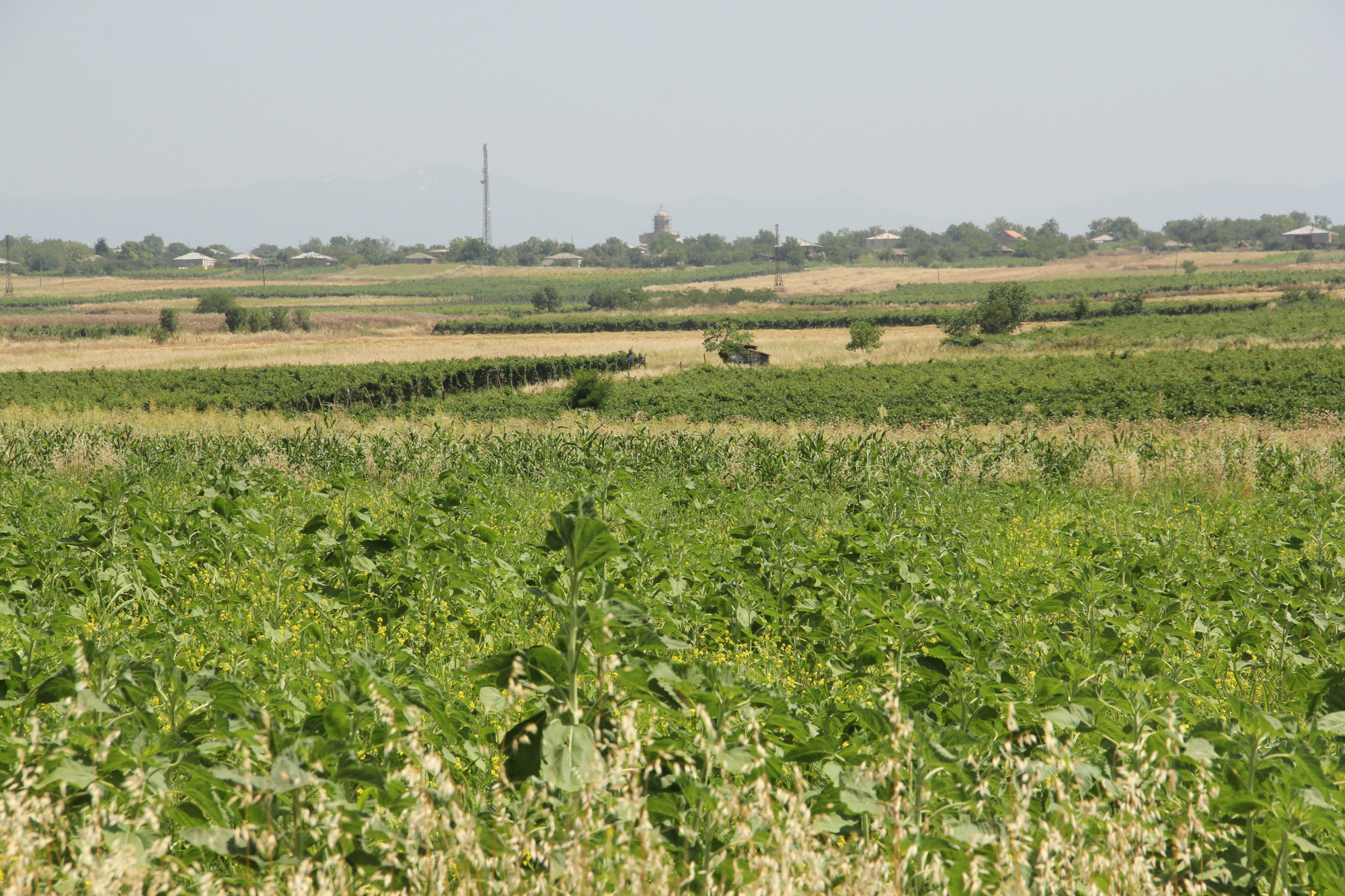
Unsustainable land use practices, such as deforestation, overgrazing and improper agricultural management systems are triggering the loss and degradation of valuable land resources in Georgia. Land use planning is one of the measures among others to contribute to support the integration of good Landscape and Sustainable Land Management (L-SLM) principles and practices into national policy and institutional framework to ensure the adoption of economically viable practices by rural communities. This technology is demonstrated in an application in Arkhiloskalo community in Eastern Georgia.
2.2 技术的详细说明
说明:
The globally ongoing degradation of land resources is threatening our food security and functioning ecosystem services. Therefore, restoration of degraded land as defined by the Sustainable Development Goal (SDG 15.3) has become a strategic objective of the UNCCD. To achieve Land Degradation Neutrality (LDN), action on the national level is needed. Georgia is one of the 113 countries (as of Sept. 2017) willing to take part in the Target Setting Program (TSP).
One of the major problems which Georgia is facing today is an absence of a comprehensive and integrated approach in the land management sector. In addition, an irrelevant legal framework sometimes leads to additional “conflicts” with the evolved national strategy and policy packages.
The land-use planning in the village of Arkhiloskalo, Dedoplistskaro Municipality is one of the pilot activities linked to LDN (Land Degradation Neutrality). The project financed by Global Environment Facility (GEF) / UN Environment Programm (UNEP) was implemented by local partner REC Caucasus (The Regional Environmental Centre for the Caucasus) through E.C.O. Institute of Ecology (Austria).
The land-use plan documents the status quo of the current land use. It is a baseline that can be used to steer and monitor future developments. The land-use plan is based on field assessments made in summer 2019 and builds a baseline for future assessments/monitoring. The land-use plan on the village level helps to break down national LDN targets to the local level. The plan and the development of land-use scenarios help to anticipate the future gains and losses of land resources and reflect the national LDN-target on the local level. Local stakeholders can identify areas of degradation risk and areas which can be rehabilitated. The Arkhiloskalo land-use plan contributes to sustainable land use by recognizing the current situation of land use and its spatial distribution as well as identifying the strength and weaknesses of the current situation.
Methodology:
Mapping for Arkhiloskalo land use plan: The mapping result is a detailed documentation of size and spatial distribution of land cover categories. Change in land cover is an important indicator to monitor the loss and gains of land resources according to the LDN monitoring concept.
For the mapping of the settlements, arable land and gardens, maps from Google Earth and digital cadastre of parcels were used. In the field maps, each polygon has an assigned Map-ID number, which is unique for each village. Polygons with the same land use category and land-use intensity can have the same Map-ID. Next to the drawing of the polygon on the map, in a field form each polygon is described by:
- Map-ID;
- Current Land use category;
- Current Land-use intensity;
- Remark (a specification of the polygon if needed).
Classifications of land use categories: The land-use classification is based on the CLC - Corine Land Classification System (The CORINE Land Cover is a vector map with a scale of 1:10 000, a minimum cartographic unit (MCU) of 100 m². It maps homogeneous landscape patterns). The Corine Land Classification system classifies urban fabric, mine, dump and construction sites, arable land, permanent crops, pastures, forests, shrubs and herbaceous vegetation associations, Open spaces with little or no vegetation, inland wetlands and waters.
The pastureland was differentiated into different productivity classes. In the field three classes of vegetation cover and species composition: low, medium, and high productivity were assessed.
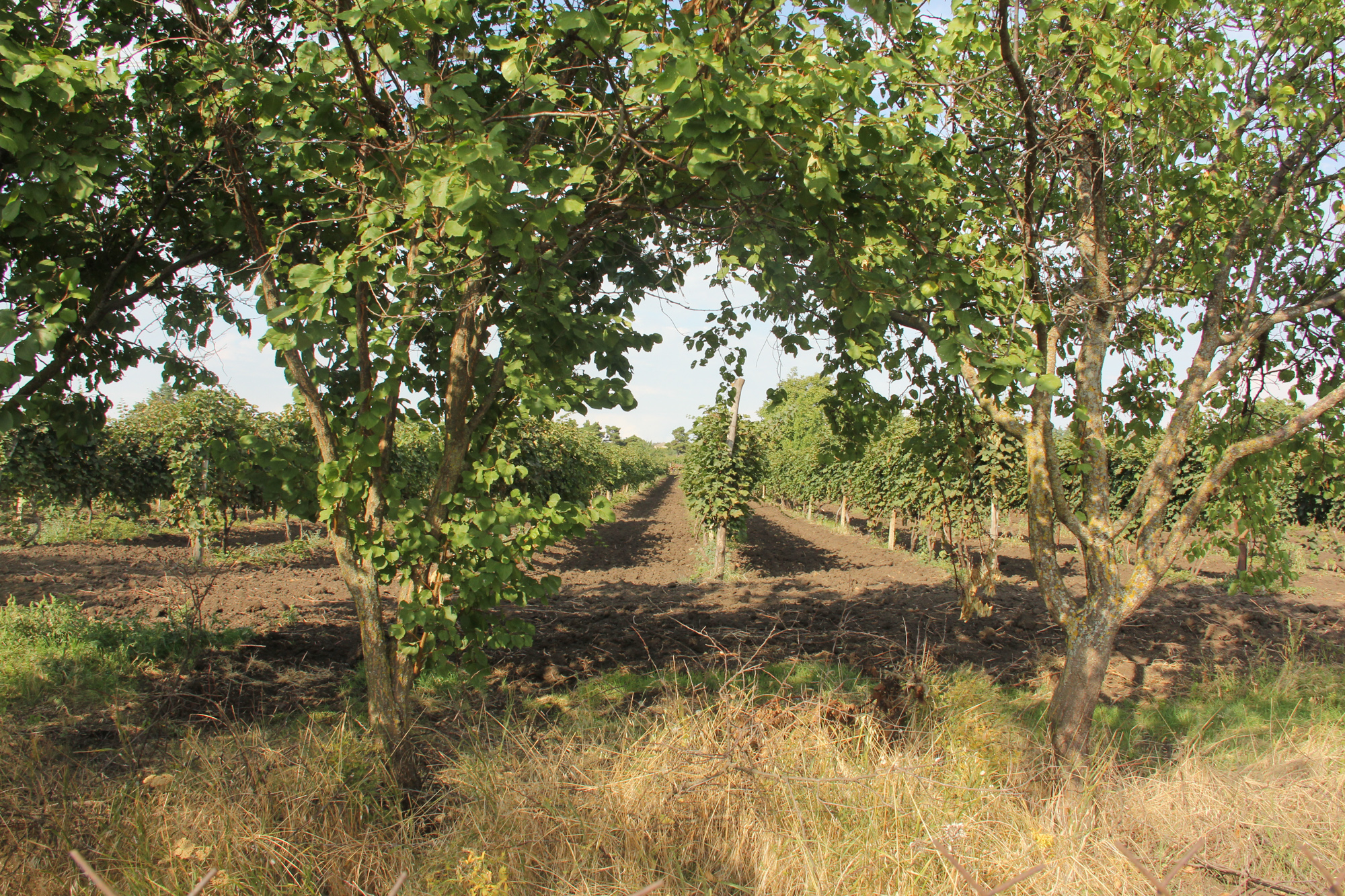
For the mapping in Arkhiloskalo the following land use categories were selected: Settlements and human infrastructure (Code from the Corine Land Classification system – e.g. SHR, name – e.g. Houses); Forests and shrub-land; Agricultural managed land; Natural and semi-natural habitats.
2.3 技术照片
媒体库
2.5 已应用该技术的、本评估所涵盖的国家/地区/地点
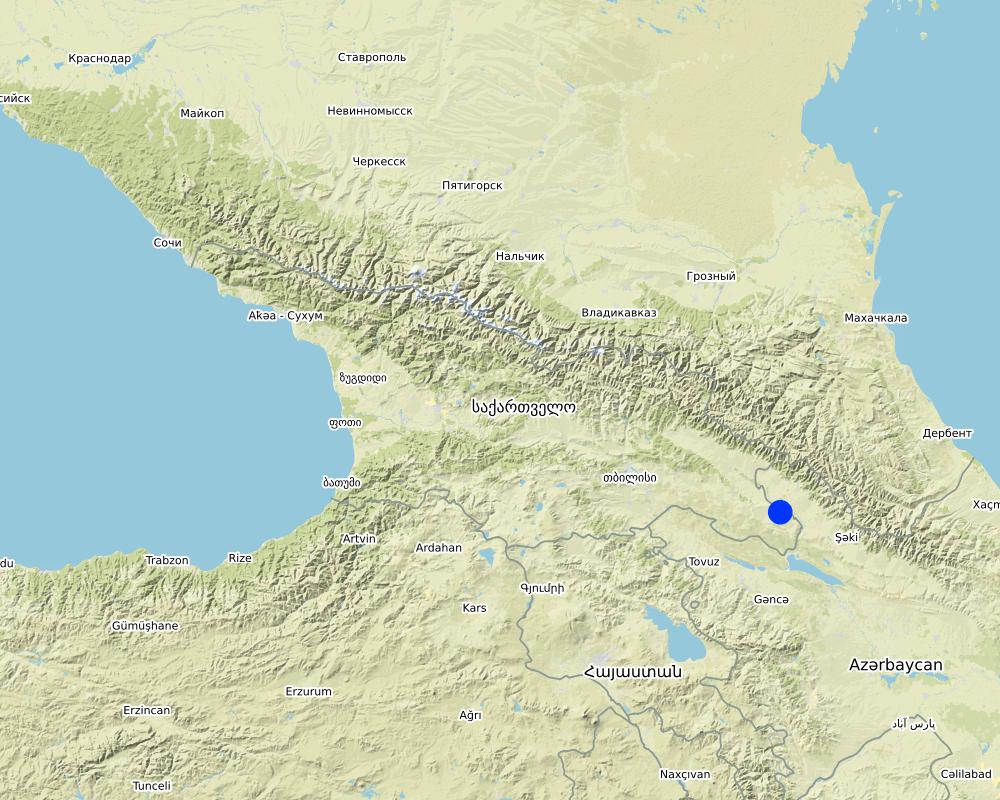
国家:
乔治亚
区域/州/省:
Kakheti
有关地点的进一步说明:
The Village of Arkhiloskalo is locted in the Municipality of Dedoplitskaro.
具体说明该技术的分布:
- 均匀地分布在一个区域
如果技术均匀分布在一个区域,则指定覆盖的区域(单位为平方千米):
49.7
如果不知道精确的区域,请注明大致覆盖的区域:
- 10-100 平方千米
注释:
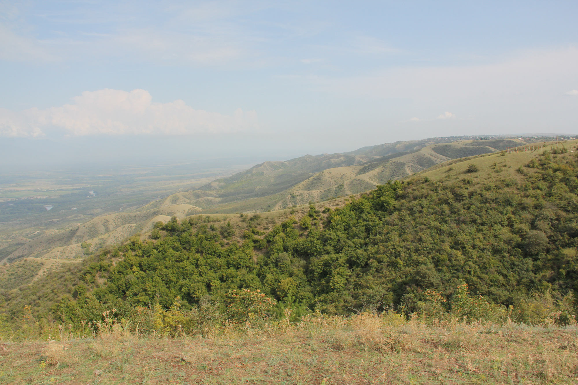
The village Arkhiloskalo covers an area of 4,970 ha. The area ranges from the lower section in the North 250 m (Alasani river valley) up to 730 m at the ridge and then falls again to the South in the Shiraki Valley to 600 m.
Map
×2.6 实施日期
注明实施年份:
2018
2.7 技术介绍
详细说明该技术是如何引入的:
- 通过项目/外部干预
注释(项目类型等):
The land-use plan approach is one of the measures among others to contribute to support the integration of good Landscape and Sustainable Land Management (L-SLM) principles and practices into national policy and institutional framework to ensure the adoption of economically viable practices by rural communities. This was a GEF-funded project.
3. SLM技术的分类
3.1 该技术的主要目的
- 改良生产
- 减少、预防、恢复土地退化
- 保持/提高生物多样性
- 适应气候变化/极端天气及其影响
- 创造有益的经济影响
3.2 应用该技术的当前土地利用类型
同一土地单元内混合使用的土地::
是
具体说明混合土地使用(作物/放牧/树木):
- 农林业

农田
- 一年一作
- 乔木与灌木的种植
年作 - 具体指明作物:
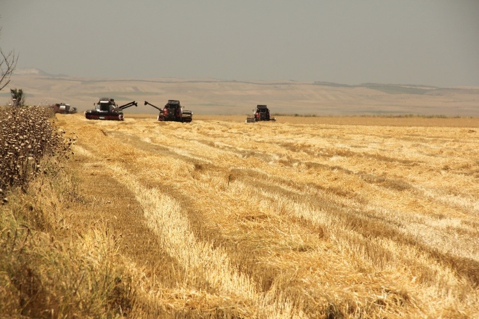
- 谷类 - 小麦(春季)
- 谷类 - 小麦(冬季)
- 油料作物 - 向日葵、菜籽、其他
乔木和灌木种植 - 指定作物:
- 水果、其他
- 葡萄
每年的生长季节数:
- 1
具体说明:
summer
采用间作制度了吗?:
否
采用轮作制度了吗?:
否

牧场
粗放式放牧:
- 经营牧场
集约放牧/饲料生产:
- 收割和携带/零放牧
- 改良牧场
动物类型:
- cattle - dairy and beef (e.g. zebu)
是否实行作物与牲畜的综合管理?:
否
品种:
cattle - dairy and beef (e.g. zebu)
计数:
982

定居点、基础设施
- 定居点、建筑物
- 交通:公路、铁路
注释:
All form of land cover and land use forms have been mapped.
3.3 由于技术的实施,土地使用是否发生了变化?
由于技术的实施,土地使用是否发生了变化?:
- 否(继续问题3.4)
3.4 供水
该技术所应用土地的供水:
- 雨养
3.5 该技术所属的SLM组
- 防风林/防护林带
- 轮作制度(轮作、休耕、轮垦)
- 废物管理/废水管理
- Land use planning
3.6 包含该技术的可持续土地管理措施

管理措施
- M2:改变管理/强度级别
- M7:其它
注释:
The land use planning started with mapping of current land use and included stakeholders input on strength and weaknesses. Based on this, development scenarios have been developed to change current land use approaches to a more sustainable way (e.g. restoration of windbreaks, crop rotation etc.)
3.7 该技术强调的主要土地退化类型

土壤风蚀
- Et:表土流失
注释:
The loss of windbreaks caused an increased exposure of topsoil to wind erosion on fields with annual crops. The land use plan helps to quantify the current state of the windbreaks and underlines their functional importance.
3.8 防止、减少或恢复土地退化
具体数量名该技术与土地退化有关的目标:
- 防止土地退化
4. 技术规范、实施活动、投入和成本
4.1 该技术的技术图纸
技术规范(与技术图纸相关):
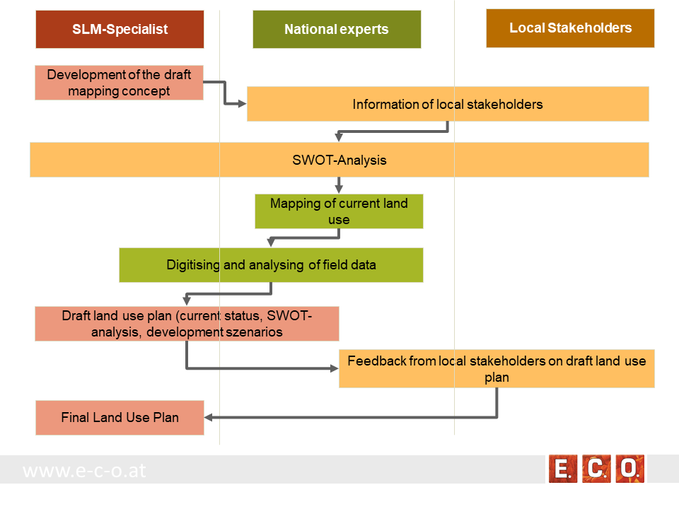
Key stages of implementation:
The land-use planning in the village of Arkhiloskalo, Dedoplistskaro Municipality is one of the pilot activities linked to LDN.
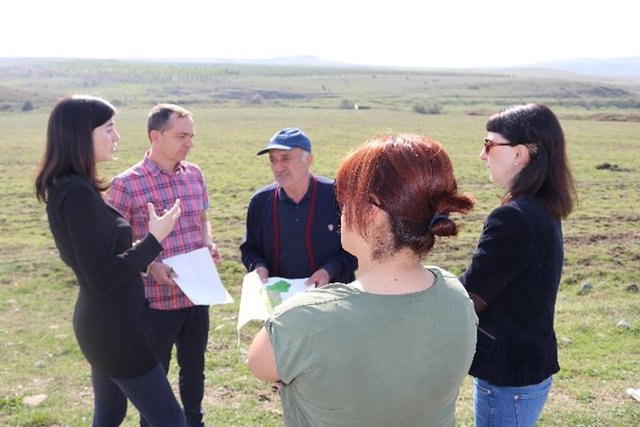
Together with the local stakeholders, a land-use plan has been worked out. The procedure of defining a spatial development plan for a municipality goes along three stages:
• Stage 1: Gather background information & implement pre-design studies and development of a mapping concept
• Stage 2: Information of local stakeholders on this activity and implementation of an SWOT analysis (Strength, Weaknesses, Opportunities, Threats) related to the land use of the village
• Stage 3: Mapping and analyzing the current land use
• Stage 4: Preparation of a draft land use plan
• Stage 5: Reflection of the draft land use plan with local stakeholders
• Stage 6: Preparation of the final land use plan
作者:
Hanns Kirchmeir
日期:
16/01/2020
技术规范(与技术图纸相关):
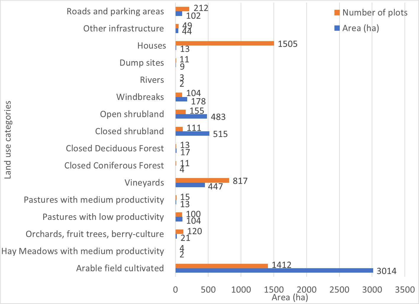
Absolute area sizes. The largest land use category is arable land (3,014 ha) followed by closed and open shrubland (515 ha and 483 ha, respectively). Vineyards cover a total of 447 ha whereas windbreaks cover 178 ha. Pastures with low productivity (104 ha) and roads and parking areas (102 ha) use almost the same amount of land. Other infrastructure covers 44 ha of land. Orchards, fruit trees and berry-culture use 21 ha of land. Closed deciduous forest (17 ha) covers only a few more hectares than pastures (13 ha). Houses are the most common plot category in Arkhiloskalo but use only around 13 ha of land which puts them on the same land-use level as pastures. Dumpsites (9 ha) use more than twice the area of closed coniferous forest (4 ha). Hay meadows and rivers cover around 2 ha of the area.
作者:
Hanns Kirchmeir
日期:
20/11/2019
技术规范(与技术图纸相关):
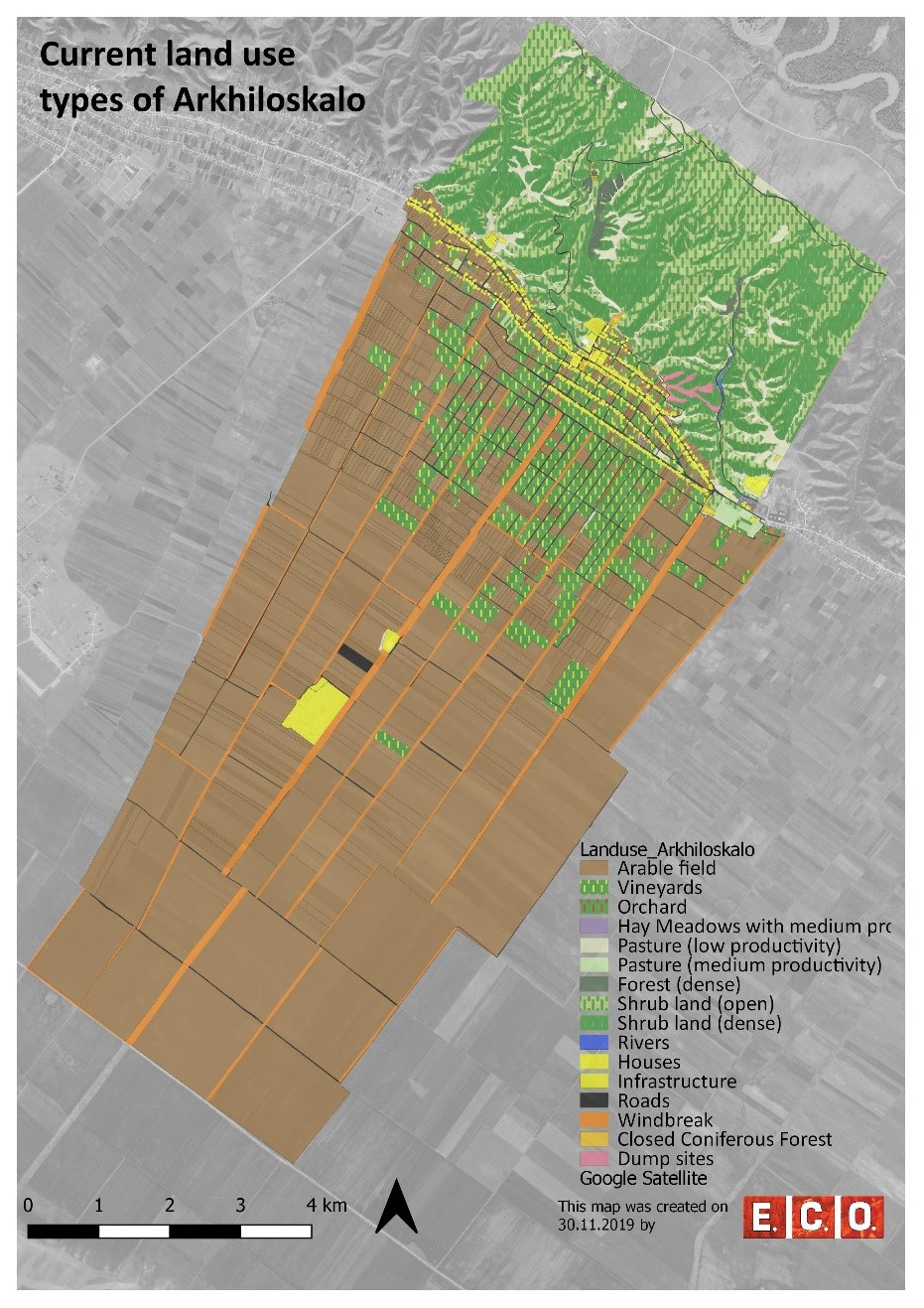
Map of current land-use categories in Arkhiloskalo. The land-use classification in this approach is based on the Corine Land Classification System. It was split into sub-categories where needed to meet the needs of local land use practices.
作者:
Hanns Kirchmeir
日期:
13/11/2019
技术规范(与技术图纸相关):
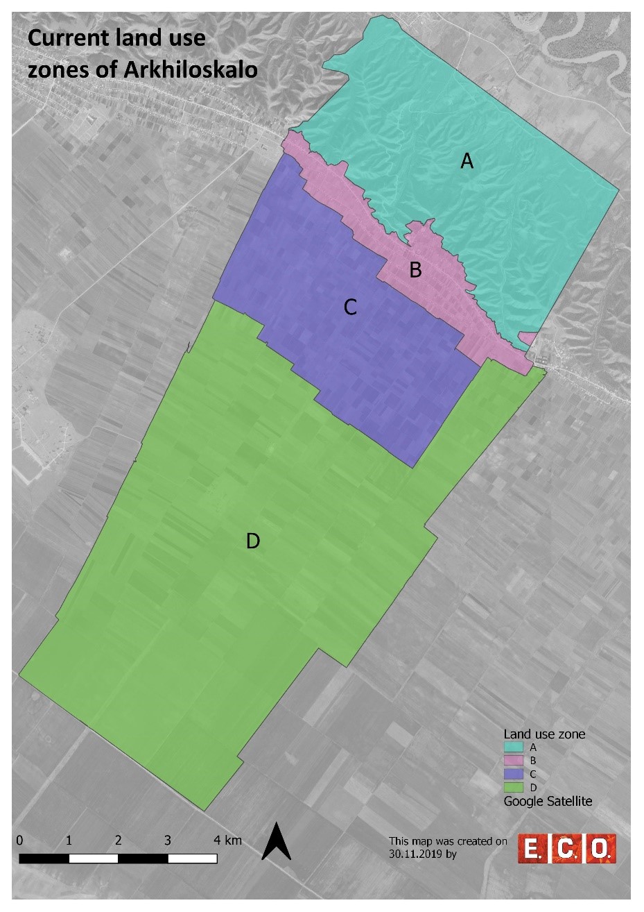
Based on the different land use, 4 different zones have been separated:
•Zone A: Steep North Slope
•Zone B. Settlement Area
•Zone C: Zone of perennial Crops
•Zone D: Zone of annual Crops
作者:
Hanns Kirchmeir
4.2 有关投入和成本计算的一般信息
具体说明成本和投入是如何计算的:
- 每个技术区域
注明尺寸和面积单位:
50 km²
具体说明成本计算所用货币:
- 美元
注明雇用劳工的每日平均工资成本:
national expert 100 USD
4.3 技术建立活动
| 活动 | 时间(季度) | |
|---|---|---|
| 1. | Gather background information & implement pre-design studies and development of a mapping concept | Winter/spring |
| 2. | Information of local stakeholders on this activity and implementation of an SWOT analysis (Strength, Weaknesses, Opportunities, Threats) related to the land use of the village | Spring |
| 3. | Mapping and analyzing the current land use | Summer |
| 4. | Preparation of a draft land use plan | Autumn/Winter |
| 5. | Reflection of the draft land use plan with local stakeholders | Autumn/Winter |
| 6. | Preparation of the final land use plan | Autumn/Winter |
4.4 技术建立所需要的费用和投入
如果您无法分解上表中的成本,请估算建立该技术所需要的总成本。:
15000.0
如果土地使用者负担的费用少于100%,请注明由谁负担其余费用:
REC-Caucasus, GEF-funded Project
注释:
The budget is $ 15 000 / per year. This amount includes the salaries of following expert, such as: National expert on SLM, National expert on LUP, International expert on SLM, International expert on LUP, Botanist, GIS expert. Also the above budget includes travels and missions in three municipalities, workshops in Akhmeta and Dedoplistskaro municipalities, workshops and public hearings in selected local communities (Arkhiloskalo and Shenako),
4.7 影响成本的最重要因素
描述影响成本的最决定性因素:
The field work of mapping and analysis of results took a lot of time as well as the stakeholder meetings.
5. 自然和人文环境
5.1 气候
年降雨量
- < 250毫米
- 251-500毫米
- 501-750毫米
- 751-1,000毫米
- 1,001-1,500毫米
- 1,501-2,000毫米
- 2,001-3,000毫米
- 3,001-4,000毫米
- > 4,000毫米
有关降雨的规范/注释:
The driest month is January, with 25 mm of rainfall. The greatest amount of precipitation occurs in June, with an average of 108 mm. The difference in precipitation between the driest month and the wettest month is 83 mm.
注明所考虑的参考气象站名称:
Dedoplistskaro Met. Station
农业气候带
- 半干旱
The climate is warm and temperate in Dedoplistskaro. The average annual temperature in Dedoplistskaro is 11.3 °C. The warmest month of the year is July, with an average temperature of 22.7 °C. The lowest average temperatures in the year occur in January, when it is around 0.1 °C.
5.2 地形
平均坡度:
- 水平(0-2%)
- 缓降(3-5%)
- 平缓(6-10%)
- 滚坡(11-15%)
- 崎岖(16-30%)
- 陡峭(31-60%)
- 非常陡峭(>60%)
地形:
- 高原/平原
- 山脊
- 山坡
- 山地斜坡
- 麓坡
- 谷底
垂直分布带:
- 0-100 m a.s.l.
- 101-500 m a.s.l.
- 501-1,000 m a.s.l.
- 1,001-1,500 m a.s.l.
- 1,501-2,000 m a.s.l.
- 2,001-2,500 m a.s.l.
- 2,501-3,000 m a.s.l.
- 3,001-4,000 m a.s.l.
- > 4,000 m a.s.l.
说明该技术是否专门应用于:
- 不相关
关于地形的注释和进一步规范:
The pastures are located on steep hill slope to the north, while the village and arable lands are located on the gently south facing terrace.
5.3 土壤
平均土层深度:
- 非常浅(0-20厘米)
- 浅(21-50厘米)
- 中等深度(51-80厘米)
- 深(81-120厘米)
- 非常深(> 120厘米)
土壤质地(表土):
- 中粒(壤土、粉土)
土壤质地(地表以下> 20厘米):
- 中粒(壤土、粉土)
表土有机质:
- 高(>3%)
5.4 水资源可用性和质量
地下水位表:
5-50米
地表水的可用性:
匮乏/没有
水质(未处理):
不良饮用水(需要处理)
水质请参考::
地下水
水的盐度有问题吗?:
否
该区域正在发生洪水吗?:
否
5.5 生物多样性
物种多样性:
- 高
栖息地多样性:
- 高
关于生物多样性的注释和进一步规范:
Especially the semi-natural landscapes of the slopes to the north are of high habitat and species diversity.
5.6 应用该技术的土地使用者的特征
定栖或游牧:
- 定栖的
生产系统的市场定位:
- 混合(生计/商业)
非农收入:
- 低于全部收入的10%
相对财富水平:
- 贫瘠
个人或集体:
- 个人/家庭
机械化水平:
- 机械化/电动
性别:
- 男人
土地使用者的年龄:
- 中年人
说明土地使用者的其他有关特征:
The village is very remote. Driving distance to the municipality is about 1h on bad roads.
5.7 应用该技术的土地使用者使用的平均土地面积
- < 0.5 公顷
- 0.5-1 公顷
- 1-2 公顷
- 2-5公顷
- 5-15公顷
- 15-50公顷
- 50-100公顷
- 100-500公顷
- 500-1,000公顷
- 1,000-10,000公顷
- > 10,000公顷
这被认为是小规模、中规模还是大规模的(参照当地实际情况)?:
- 中等规模的
5.8 土地所有权、土地使用权和水使用权
土地所有权:
- 社区/村庄
- 个人,有命名
土地使用权:
- 自由进入(无组织)
- 个人
用水权:
- 社区(有组织)
土地使用权是否基于传统的法律制度?:
是
5.9 进入服务和基础设施的通道
健康:
- 贫瘠
- 适度的
- 好
教育:
- 贫瘠
- 适度的
- 好
技术援助:
- 贫瘠
- 适度的
- 好
市场:
- 贫瘠
- 适度的
- 好
能源:
- 贫瘠
- 适度的
- 好
道路和交通:
- 贫瘠
- 适度的
- 好
饮用水和卫生设施:
- 贫瘠
- 适度的
- 好
金融服务:
- 贫瘠
- 适度的
- 好
6. 影响和结论性说明
6.1 该技术的现场影响
社会经济效应
生产
作物生产
注释/具体说明:
Effects will be visible based on the implementation of selected development scenario provided by Land use plan.
产品多样性
注释/具体说明:
Effects will be visible based on the implementation of selected development scenario provided by Land use plan.
收入和成本
收入来源的多样性
注释/具体说明:
Effects will be visible based on the implementation of selected development scenario provided by Land use plan.
社会文化影响
SLM/土地退化知识
注释/具体说明:
Improvements by training and workshops, awareness raising.
生态影响
生物多样性:植被、动物
植被覆盖
注释/具体说明:
Reduced grazing in zone A (north slope) will increase the vegetation cover. Effects will be visible based on the implementation of selected development scenario provided by Land use plan.
生物量/地上C
注释/具体说明:
Reduced grazing in zone A (north slope) will increase the cover of shrubs and trees which will lead to increase of biomass. Effects will be visible based on the implementation of selected development scenario provided by Land use plan.
动物多样性
注释/具体说明:
Effects will be visible based on the implementation of selected development scenario provided by Land use plan.
栖息地多样性
注释/具体说明:
Diversification of land use and restoration of windbreaks will increase habitat diversity. Effects will be visible based on the implementation of selected development scenario provided by Land use plan.
减少气候和灾害风险
风速
注释/具体说明:
Improvement of windbreaks will reduce wind speed and topoil erosion. Effects will be visible based on the implementation of selected development scenario provided by Land use plan.
6.2 该技术的场外影响已经显现
地下水/河流污染
注释/具体说明:
Removal of uncontrolled dump sites will reduce groundwater and river pollution especially in the Alasani floodplain north of the community.
风力搬运沉积物
注释/具体说明:
The rehabilitation of windbreaks will have a positive impact on neighboring fields.
6.3 技术对渐变气候以及与气候相关的极端情况/灾害的暴露和敏感性(土地使用者认为的极端情况/灾害)
注释:
The technology of land use planning is not sensitive to climate change but is an appropriate technology to adapt land use to future anticipated climate changes.
6.4 成本效益分析
技术收益与技术建立成本相比如何(从土地使用者的角度看)?
短期回报:
消极
长期回报:
积极
技术收益与技术维护成本/经常性成本相比如何(从土地使用者的角度看)?
短期回报:
中性/平衡
长期回报:
中性/平衡
注释:
The land use planning process is an investment in future developments. Return of investment can be expected in oncoming years. The mapping result is a detailed documentation of size and spatial distribution land cover categories. Change in land cover is an important indicator to monitor the loss and gains according to the LDN monitoring concept. The land-use plan is based on field assessments made in summer 2019 and built a baseline for future change assessments as it includes data on land-use intensity which will enable to consider change in time dynamics and to monitor changes on the ground.
6.5 技术采用
- 单例/实验
如若可行,进行量化(住户数量和/或覆盖面积):
It was implemented as show case for one community
在所有采用这项技术的人当中,有多少人是自发的,即未获得任何物质奖励/付款?:
- 0-10%
6.6 适应
最近是否对该技术进行了修改以适应不断变化的条件?:
否
6.7 该技术的优点/长处/机会
| 土地使用者眼中的长处/优势/机会 |
|---|
| The majority of the land users in village Arkhiloskalo have been using the same land and natural resources through decades and have good understanding of the natural conditions and climate change perspectives of the target area. The land use plan, the scenario development and the knowledge exchange in the workshops are have been considered as advantage for awareness raising, joint decision making and to start a positive change in short-term period. |
| The successful land-use system with improved environment conditions and benefit to the local farmers can lead to be a perfect example for the whole municipality of Dedoplistskaro as most part of its territory is agricultural land in semi-arid environment facing some rapid and significant challenges caused by climate change. |
| 编制者或其他关键资源人员认为的长处/优势/机会 |
|---|
| The land use plan will help to optimize the management and to eliminate present challenges in the 4 separate zones and promote improved sustainable land- use, land-management practices like crop rotation and re-establishment of windbreaks. |
| The land-use plan helps to identify the strength, opportunities, weaknesses and threats and contribute to sustainable land-use and its management. E.g.: in the Zone A, Steep North Slope there is a high risk, that the waste in the dumpsites will be washed down in an uncontrolled manner into the natural and semi-natural habitats of the slope. The waste is partly burned and the wash out of toxic solute can harm nature and ground water. |
| Application of the technology helps to optimize management measures, which will reduce costs and labour forces, e.g., by increasing productivity of land and productivity of vineyards in the Zone C: zone of perennial crops. |
| The land-use map integrates climate mitigation. E.g. it helps to plan the re-establishment of the windbreaks, which significantly contributes to the reduction of wind erosion in the Zone D: Zone of annual crops. |
| The terrestrial evaluation of the current land use can also serve to evaluate remote sensing technologies for semi-automatic classification of land cover categories. |
6.8 技术的弱点/缺点/风险及其克服方法
| 土地使用者认为的弱点/缺点/风险 | 如何克服它们? |
|---|---|
| Lack of dialogue and trust could be one of the risks to succeed with the introduction of advanced methods of sustainable land management. | The proposed sustainable land-use practices and pilot activities should be planned in a way to have results on the ground in a short-term period to keep local farmers motivated. |
| 编制者或其他关键资源人员认为的弱点/缺点/风险 | 如何克服它们? |
|---|---|
| Risks: Land use plan Interest of farmers, guesthouse providers and local residents are conflicting. | This can be limited by good facilitation of focus group discussions between different stakeholder groups. |
| Local actors (farmers, guest house providers ...) are not interested in participating in the joint land-use planning process. | It will need a well-coordinated communication design to include all the local stakeholders in the process of practical and theoretical introduction to the principles of sustainable land-use. The communication should emphasize potential economic benefits to the local households together with advantages of the sustainability. This can be a key factor to get most of the local stakeholders engaged with the proposed sustainable land-use practices. |
7. 参考和链接
7.1 信息的方法/来源
- 实地考察、实地调查
2 days of joint field visit of the project team, 2 weeks of field-mapping of the national expert.
- 与土地使用者的访谈
About 44 participants in workshops and 12 people interviewed.
- 与SLM专业人员/专家的访谈
2 specialists
- 根据报告和其他现有文档进行编译
1 international expert and 3 national experts have been conducted for the feedback on the report.
(现场)数据是什么时候汇编的?:
12/08/2018
7.2 参考可用出版物
标题、作者、年份、ISBN:
Pilot project on land degradation neutrality in Georgia: Final Report.2017.Huber, M., Joseph, A., Kirchmeir, H., Ghambashidze, G.
可以从哪里获得?成本如何?
https://e-c-o.at/files/publications/downloads/D00813_ECO_policy_brief_LDN_Georgia_171025.pdf
标题、作者、年份、ISBN:
Applying Landscape and Sustainable Land Management (L-SLM) for mitigating land degradation and contributing to poverty reduction in rural areas: Final report. 2017. Kirchmeir, H., Joseph, A., Huber, M.
可以从哪里获得?成本如何?
Request at RECC Caucasus
标题、作者、年份、ISBN:
limatologies at high resolution for the earth’s land surface areas. Sci. Data 4:170122 doi: 10.1038/sdata.2017. Karger, D. N. Conrad, O., Böhner, J., Kawohl, T., Kreft, H., Soria-Auza, R.W., Zimmermann, N.E., Linder H.P. & Kessler M.
可以从哪里获得?成本如何?
https://www.nature.com/articles/sdata2017122
7.4 一般注释
It was not easy to consider the land use planning either to be a technology or an approach. Finally, we submitted as an approach.
链接和模块
全部展开 全部收起链接
Land Degradation Neutrality Transformative Projects and Programmes (LDN-TPP) … [乔治亚]
In the framework of the project ‘Generating Economic and Environmental Benefits from Sustainable Land Management for Vulnerable Rural Communities of Georgia’, Land Degradation Neutrality Transformative Projects and Programmes (LDN-TPP) were developed to implement the LDN targets at municipal level. The approach defines the process to break down global and international …
- 编制者: Daniel Zollner
模块
无模块