Natural riparian vegetation to sustain a stable riverbank at Naro Moru River [Kenya]
- Création :
- Mise à jour :
- Compilateur : Manuel Fischer
- Rédacteur : –
- Examinateurs : David Streiff, Alexandra Gavilano
technologies_1569 - Kenya
- Résumé complet en PDF
- Résumé complet en PDF pour impression
- Résumé complet dans le navigateur
- Résumé complet (non formaté)
- Natural riparian vegetation to sustain a stable riverbank at Naro Moru River: 30 mars 2017 (inactive)
- Natural riparian vegetation to sustain a stable riverbank at Naro Moru River: 30 mars 2017 (inactive)
- Natural riparian vegetation to sustain a stable riverbank at Naro Moru River: 8 mai 2019 (public)
Voir les sections
Développer tout Réduire tout1. Informations générales
1.2 Coordonnées des personnes-ressources et des institutions impliquées dans l'évaluation et la documentation de la Technologie
exploitant des terres:
Ngunjiri Simon
Kenya
1.3 Conditions relatives à l'utilisation par WOCAT des données documentées
Le compilateur et la(les) personne(s) ressource(s) acceptent les conditions relatives à l'utilisation par WOCAT des données documentées:
Oui
2. Description de la Technologie de GDT
2.1 Courte description de la Technologie
Définition de la Technologie:
Riverbank erosion and biodiversity decline in the riparian area can be overcome by leaving the natural vegetation undisturbed.
2.2 Description détaillée de la Technologie
Description:
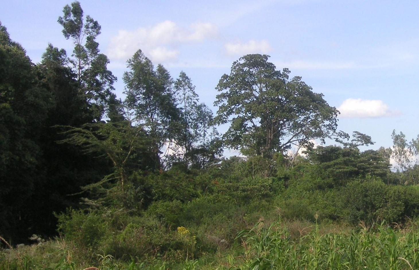
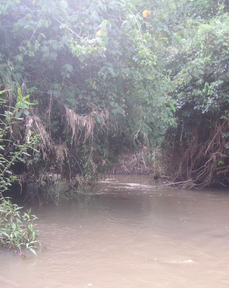
The studied land plot is situated in the semi-arid savannah zone of the Naro Moru sub-catchment at the foot of Mt. Kenya. A small-scale farmer leaves the riparian vegetation undisturbed, which enables the growth of dense bushes. On the one hand, the riparian vegetation contributes to prevent land loss caused by riverbank erosion, on the other hand it is a habitat for the special riparian fauna and flora.
Purpose of the Technology: Despite semi-arid conditions, there is a high probability of flooding. Heavy rainfalls on upper slopes of Mt. Kenya lead to flood events in the semi-arid areas of Naro Moru River. These events have a destructive effect on the riverbanks, which have become instable by human induced activities such as overgrazing and deforestation. The instable riparian soils are eroded easily. The farmers lose their precious land and the water is polluted.
Establishment / maintenance activities and inputs: A good way to overcome the riverbank degradation triggered by high runoff is a passive approach: simply leaving the riparian area undisturbed by human interference. Trees, bushes and grasses stabilize even steep riverbanks with their invading roots. As a result, almost no erosion takes place and infiltration is enhanced during rain events. The riparian microclimate, which is characterized by cooler temperatures during the day and slightly warmer temperatures during the night, is very special compared to the surrounding semi-arid zones. Also water availability is much higher than in the surroundings. Thus, this habitat offers a high biodiversity.
Natural / human environment: The plot is situated on a plateau at the western side of Mt. Kenya. There is not the same amount of precipitation as at the foot slopes of Mt. Kenya. However, the area still benefits from the runoff that is generated on the mountain. Precipitation in the so-called savannah zone ranges from 600mm to 900mm per year. Due to the high evaporation, rain-fed agriculture is only partly possible. Therefore most land users depend on irrigation using river water.
During the last decades, the region has experienced a still continuing population growth which increases population pressure in the area and removal and use of the vegetation along the rivers. The good accessibility and the moderate tourism allow even off-farm income-generation.
2.3 Photos de la Technologie
Galerie Médias
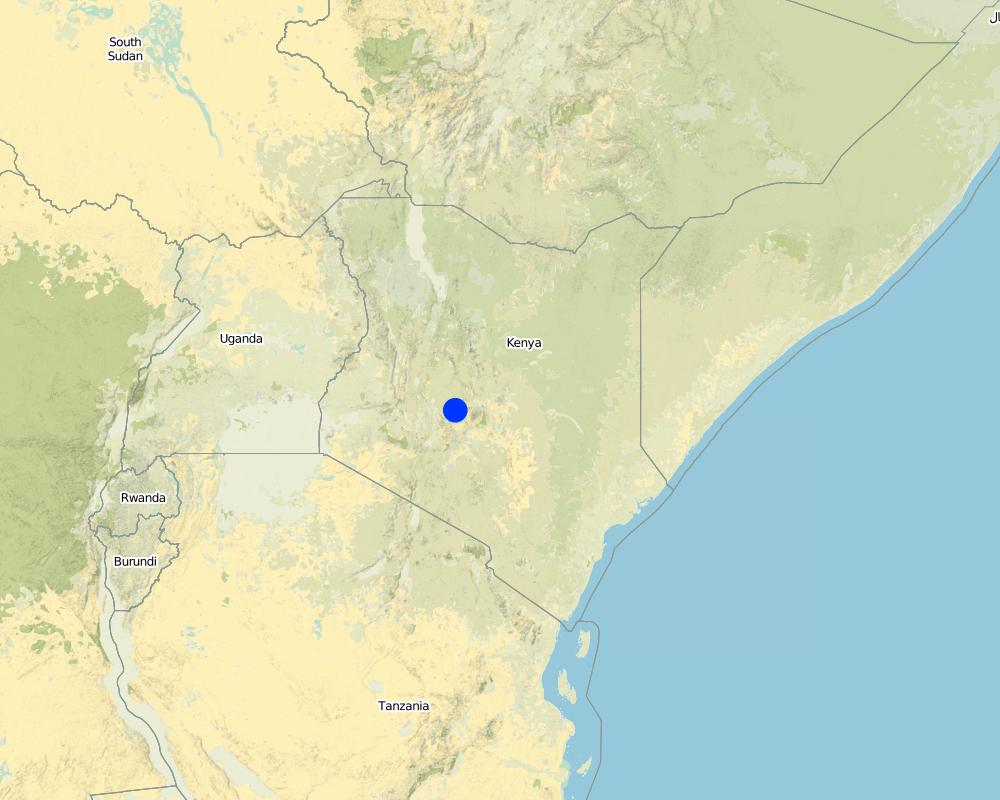
2.5 Pays/ région/ lieux où la Technologie a été appliquée et qui sont couverts par cette évaluation
Pays:
Kenya
Région/ Etat/ Province:
Kenya/Central Province
Autres spécifications du lieu:
Naro Moru
Spécifiez la diffusion de la Technologie:
- répartie uniformément sur une zone
S'il n'existe pas d'informations exactes sur la superficie, indiquez les limites approximatives de la zone couverte:
- < 0,1 km2 (10 ha)
Commentaires:
The riparian area is very small, thus the whole plot of the farmer is indicated.
Map
×2.6 Date de mise en œuvre de la Technologie
Si l'année précise est inconnue, indiquez la date approximative: :
- il y a entre 10-50 ans
2.7 Introduction de la Technologie
Spécifiez comment la Technologie a été introduite: :
- grâce à l'innovation d'exploitants des terres
Commentaires (type de projet, etc.) :
The farmer has not touched the land since 20 years.
3. Classification de la Technologie de GDT
3.1 Principal(aux) objectif(s) de la Technologie
- conserver/ améliorer la biodiversité
- réduire les risques de catastrophes
3.2 Type(s) actuel(s) d'utilisation des terres, là où la Technologie est appliquée

Forêts/ bois
Produits et services:
- Conservation/ protection de la nature
- Protection contre les aléas naturels
Commentaires:
Major land use problems (compiler’s opinion): In not treated areas, land users have to fight serious riverbank erosion. Due to steep riverbanks, stabilisation is very tricky.
Major land use problems (land users’ perception): Deforested riverbanks are very difficult to control, land loss is a consequence.
Other type of forest: Protected riparian forest
Problems / comments regarding forest use: The forest is left as protected forest because it stabilizes the riverbank.
Forest products and services: nature conservation / protection, protection against natural hazards
Number of growing seasons per year: 2
Longest growing period in days: 60 Longest growing period from month to month: april to may Second longest growing period in days: 60 Second longest growing period from month to month: october to november
3.5 Groupe de GDT auquel appartient la Technologie
- fermeture de zones (arrêt de tout usage, appui à la réhabilitation)
- gestion des eaux de surface (sources, rivières, lacs, mers)
3.6 Mesures de GDT constituant la Technologie

modes de gestion
- M5: Contrôle/ changement de la composition des espèces
Commentaires:
Main measures: management measures
3.7 Principaux types de dégradation des terres traités par la Technologie

érosion hydrique des sols
- Wt: perte de la couche superficielle des sols (couche arable)/ érosion de surface
- Wr: érosion des berges

dégradation biologique
- Bc: réduction de la couverture végétale
- Bh: perte d’habitats
- Bq: baisse de la quantité/ biomasse

dégradation hydrique
- Hg: changement du niveau des nappes phréatiques (eaux souterraines) et des aquifères
- Hp: baisse de la qualité des eaux de surface
- Hw: réduction de la capacité tampon des zones humides
Commentaires:
Main type of degradation addressed: Wr: riverbank erosion, Hp: decline of surface water quality
Secondary types of degradation addressed: Wt: loss of topsoil / surface erosion, Bc: reduction of vegetation cover, Bh: loss of habitats, Bq: quantity / biomass decline, Hg: change in groundwater / aquifer level, Hw: reduction of the buffering capacity of wetland areas
Main causes of degradation: deforestation / removal of natural vegetation (incl. forest fires), over-exploitation of vegetation for domestic use, overgrazing, floods
Secondary causes of degradation: Heavy / extreme rainfall (intensity/amounts), population pressure, poverty / wealth
3.8 Prévention, réduction de la dégradation ou réhabilitation des terres dégradées
Spécifiez l'objectif de la Technologie au regard de la dégradation des terres:
- prévenir la dégradation des terres
4. Spécifications techniques, activités, intrants et coûts de mise en œuvre
4.1 Dessin technique de la Technologie
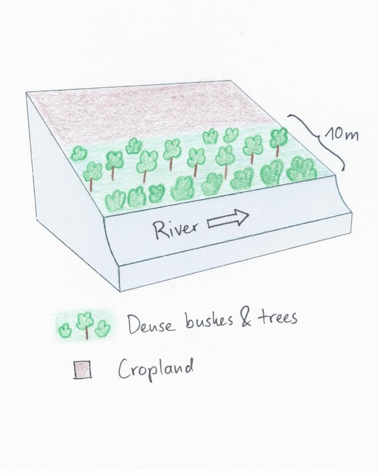
Spécifications techniques (associées au dessin technique):
The land user noticed the riverbank erosion problems neighbours had after clearing of the riparian vegetation. This led to the protective approach of natural trees and bushes. Adjacent to the riparian area, crops are cultivated.
Location: Naro Moru. Nyeri / Central Province
Date: 28.12.2013
Technical knowledge required for field staff / advisors: low
Technical knowledge required for land users: low
Main technical functions: stabilisation of soil (eg by tree roots against land slides), increase of infiltration, improvement of water quality, buffering / filtering water, sediment retention / trapping, sediment harvesting
Secondary technical functions: improvement of ground cover, increase of surface roughness, increase / maintain water stored in soil, increase of groundwater level / recharge of groundwater
Control / change of species composition: In the protected area only indigenous tress, bushes and grasses should be present. Especially indigenous trees do not need much water and allow more water to infiltrate into the soil.
Auteur:
Manuel Fischer
4.2 Informations générales sur le calcul des intrants et des coûts
Spécifiez la manière dont les coûts et les intrants ont été calculés:
- par entité de la Technologie
Précisez l'unité:
Riparian area
Précisez les dimensions de l'unité de terrain (le cas échéant):
60 m
autre/ monnaie nationale (précisez):
Kenyan Shilling
Indiquez le taux de change des USD en devise locale, le cas échéant (p.ex. 1 USD = 79.9 réal brésilien): 1 USD = :
90,0
Indiquez le coût salarial moyen de la main d'œuvre par jour:
2.70
4.3 Activités de mise en place/ d'établissement
| Activité | Calendrier des activités (saisonnier) | |
|---|---|---|
| 1. | No activities were needed |
4.5 Activités d'entretien/ récurrentes
| Activité | Calendrier/ fréquence | |
|---|---|---|
| 1. | Control of species composition and destruction of invading plants | during rainy season |
4.6 Coûts et intrants nécessaires aux activités d'entretien/ récurrentes (par an)
| Spécifiez les intrants | Unité | Quantité | Coûts par unité | Coût total par intrant | % du coût supporté par les exploitants des terres | |
|---|---|---|---|---|---|---|
| Main d'œuvre | Control of species composition and destruction of invading plants | Persons/day | 2,0 | 3,0 | 6,0 | 100,0 |
| Coût total d'entretien de la Technologie | 6,0 | |||||
| Coût total d'entretien de la Technologie en dollars américains (USD) | 0,07 | |||||
5. Environnement naturel et humain
5.1 Climat
Précipitations annuelles
- < 250 mm
- 251-500 mm
- 501-750 mm
- 751-1000 mm
- 1001-1500 mm
- 1501-2000 mm
- 2001-3000 mm
- 3001-4000 mm
- > 4000 mm
Zone agro-climatique
- semi-aride
Thermal climate class: subtropics
5.2 Topographie
Pentes moyennes:
- plat (0-2 %)
- faible (3-5%)
- modéré (6-10%)
- onduleux (11-15%)
- vallonné (16-30%)
- raide (31-60%)
- très raide (>60%)
Reliefs:
- plateaux/ plaines
- crêtes
- flancs/ pentes de montagne
- flancs/ pentes de colline
- piémonts/ glacis (bas de pente)
- fonds de vallée/bas-fonds
Zones altitudinales:
- 0-100 m
- 101-500 m
- 501-1000 m
- 1001-1500 m
- 1501-2000 m
- 2001-2500 m
- 2501-3000 m
- 3001-4000 m
- > 4000 m
Commentaires et précisions supplémentaires sur la topographie:
Altitudinal zone: 1800 m a.s.l.
5.3 Sols
Profondeur moyenne du sol:
- très superficiel (0-20 cm)
- superficiel (21-50 cm)
- modérément profond (51-80 cm)
- profond (81-120 cm)
- très profond (>120 cm)
Texture du sol (de la couche arable):
- moyen (limoneux)
Matière organique de la couche arable:
- moyen (1-3%)
Si disponible, joignez une description complète du sol ou précisez les informations disponibles, par ex., type de sol, pH/ acidité du sol, capacité d'échange cationique, azote, salinité, etc.
Soil fertility is medium
Soil drainage / infiltration is poor - medium
Soil water storage capacity is low but with mulching it changes to medium
5.4 Disponibilité et qualité de l'eau
Profondeur estimée de l’eau dans le sol:
< 5 m
Disponibilité de l’eau de surface:
bonne
Qualité de l’eau (non traitée):
faiblement potable (traitement nécessaire)
Commentaires et précisions supplémentaires sur la qualité et la quantité d'eau:
Ground water table: Just along the river, deeper ground water level 50-100m
5.5 Biodiversité
Diversité des espèces:
- moyenne
5.6 Caractéristiques des exploitants des terres appliquant la Technologie
Orientation du système de production:
- subsistance (auto-approvisionnement)
Revenus hors exploitation:
- moins de 10% de tous les revenus
Niveau relatif de richesse:
- pauvre
Individus ou groupes:
- individu/ ménage
Genre:
- femmes
- hommes
Indiquez toute autre caractéristique pertinente des exploitants des terres:
Land users applying the Technology are mainly common / average land users
Population density: 200-500 persons/km2
Off-farm income specification: The farmer has no off-farm income.
5.7 Superficie moyenne des terres utilisées par les exploitants des terres appliquant la Technologie
- < 0,5 ha
- 0,5-1 ha
- 1-2 ha
- 2-5 ha
- 5-15 ha
- 15-50 ha
- 50-100 ha
- 100-500 ha
- 500-1 000 ha
- 1 000-10 000 ha
- > 10 000 ha
Cette superficie est-elle considérée comme de petite, moyenne ou grande dimension (en se référant au contexte local)?
- petite dimension
5.8 Propriété foncière, droits d’utilisation des terres et de l'eau
Propriété foncière:
- individu, sans titre de propriété
Droits d’utilisation des terres:
- individuel
Droits d’utilisation de l’eau:
- accès libre (non organisé)
- communautaire (organisé)
5.9 Accès aux services et aux infrastructures
santé:
- pauvre
- modéré
- bonne
éducation:
- pauvre
- modéré
- bonne
assistance technique:
- pauvre
- modéré
- bonne
emploi (par ex. hors exploitation):
- pauvre
- modéré
- bonne
marchés:
- pauvre
- modéré
- bonne
énergie:
- pauvre
- modéré
- bonne
routes et transports:
- pauvre
- modéré
- bonne
eau potable et assainissement:
- pauvre
- modéré
- bonne
services financiers:
- pauvre
- modéré
- bonne
6. Impacts et conclusions
6.1 Impacts sur site que la Technologie a montrés
Impacts socio-économiques
Production
production de bois
Commentaires/ spécifiez:
Before the establishment of the technology, the farmer used to prune the trees. He does not do that anymore.
Impacts socioculturels
connaissances sur la GDT/ dégradation des terres
aesthetics
Livelihood and human well-being
Commentaires/ spécifiez:
Erosion knowledge was improved
Impacts écologiques
Cycle de l'eau/ ruissellement
quantité d'eau
qualité de l'eau
nappes phréatiques/ aquifères
Sols
humidité du sol
couverture du sol
Biodiversité: végétale, animale
diversité végétale
espèces bénéfiques
diversité des habitats
Réduction des risques de catastrophe et des risques climatiques
impacts de la sécheresse
Autres impacts écologiques
Riverbank erosion
6.2 Impacts hors site que la Technologie a montrés
disponibilité de l'eau
flux des cours d'eau fiables et stables en saison sèche
envasement en aval
pollution des rivières/ nappes phréatiques
capacité tampon/de filtration
6.3 Exposition et sensibilité de la Technologie aux changements progressifs et aux évènements extrêmes/catastrophes liés au climat (telles que perçues par les exploitants des terres)
Changements climatiques progressifs
Changements climatiques progressifs
| Saison | Augmentation ou diminution | Comment la Technologie fait-elle face à cela? | |
|---|---|---|---|
| températures annuelles | augmente | bien |
Extrêmes climatiques (catastrophes)
Catastrophes météorologiques
| Comment la Technologie fait-elle face à cela? | |
|---|---|
| pluie torrentielle locale | bien |
| tempête de vent locale | bien |
Catastrophes climatiques
| Comment la Technologie fait-elle face à cela? | |
|---|---|
| sécheresse | bien |
Catastrophes hydrologiques
| Comment la Technologie fait-elle face à cela? | |
|---|---|
| inondation générale (rivière) | bien |
Autres conséquences liées au climat
Autres conséquences liées au climat
| Comment la Technologie fait-elle face à cela? | |
|---|---|
| réduction de la période de croissance | bien |
6.4 Analyse coûts-bénéfices
Quels sont les bénéfices comparativement aux coûts de mise en place (du point de vue des exploitants des terres)?
Rentabilité à court terme:
neutre / équilibrée
Rentabilité à long terme:
légèrement positive
Quels sont les bénéfices comparativement aux coûts d'entretien récurrents (du point de vue des exploitants des terres)?
Rentabilité à court terme:
neutre / équilibrée
Rentabilité à long terme:
légèrement positive
Commentaires:
There are no establishment costs, that is why the short-term returns ares neutral. After some years, the benefits develop as long-term returns
6.5 Adoption de la Technologie
- cas isolés/ expérimentaux
De tous ceux qui ont adopté la Technologie, combien d'entre eux l'ont fait spontanément, à savoir sans recevoir aucune incitation matérielle, ou aucune rémunération? :
- 11-50%
Commentaires:
20% of land user families have adopted the Technology without any external material support
There is a little trend towards spontaneous adoption of the Technology
Comments on adoption trend: There are some farmers who are very convinced. The number of farmers adopting the technology is growing slowly.
6.7 Points forts/ avantages/ possibilités de la Technologie
| Points forts/ avantages/ possibilités du point de vue de l'exploitant des terres |
|---|
|
There are no problems with riverbank erosion. How can they be sustained / enhanced? Keep the vegetation cover and do not perform too many activities in the riparian zone. |
| Points forts/ avantages/ possibilités du point de vue du compilateur ou d'une autre personne ressource clé |
|---|
|
The technology creates a habitat for the very specific riparian fauna and flora and this boosts biodiversity. How can they be sustained / enhanced? By enlarging the riparian zone. |
6.8 Faiblesses/ inconvénients/ risques de la Technologie et moyens de les surmonter
| Faiblesses/ inconvénients/ risques du point de vue du compilateur ou d'une autre personne ressource clé | Comment peuvent-ils être surmontés? |
|---|---|
| There is no productive use of this technology, therefore it is difficult to convince other farmers to adopt this technology. | Slight use of the riparian brings already good returns of fodder and fuelwood and still allows good protection. |
7. Références et liens
7.1 Méthodes/ sources d'information
Liens et modules
Développer tout Réduire toutLiens
Aucun lien
Modules
Aucun module trouvé