Natural riparian vegetation to sustain a stable riverbank at Naro Moru River [ប្រទេសកេនយ៉ា]
- ការបង្កើត៖
- បច្ចុប្បន្នភាព
- អ្នកចងក្រង៖ Manuel Fischer
- អ្នកកែសម្រួល៖ –
- អ្នកត្រួតពិនិត្យច្រើនទៀត៖ David Streiff, Alexandra Gavilano
technologies_1569 - ប្រទេសកេនយ៉ា
- សង្ខេបជា PDF
- សេចក្តីសង្ខេបពេញលេញជាទម្រង់ PDF សម្រាប់បោះពុម្ព
- សេចក្តីសង្ខេបពេញលេញទម្រង់អ៊ីនធឺនេត
- សេចក្តីសង្ខេបពេញលេញ (មិនមានទម្រង់ជាក់លាក់)
- Natural riparian vegetation to sustain a stable riverbank at Naro Moru River: 30 ខែ មិនា ឆ្នាំ 2017 (inactive)
- Natural riparian vegetation to sustain a stable riverbank at Naro Moru River: 30 ខែ មិនា ឆ្នាំ 2017 (inactive)
- Natural riparian vegetation to sustain a stable riverbank at Naro Moru River: 8 ខែ ឧសភា ឆ្នាំ 2019 (public)
ពិនិត្យមើលគ្រប់ផ្នែក
ពង្រីកមើលទាំងអស់ បង្រួមទាំងអស់1. ព័ត៌មានទូទៅ
1.2 ព័ត៌មានលម្អិតពីបុគ្គលសំខាន់ៗ និងស្ថាប័នដែលចូលរួមក្នុងការវាយតម្លៃ និងចងក្រងឯកសារនៃបច្ចេកទេស
អ្នកប្រើប្រាស់ដី:
Ngunjiri Simon
ប្រទេសកេនយ៉ា
1.3 លក្ខខណ្ឌទាក់ទងទៅនឹងការប្រើប្រាស់ទិន្នន័យដែលបានចងក្រងតាមរយៈ វ៉ូខេត
អ្នកចងក្រង និង(បុគ្គលសំខាន់ៗ)យល់ព្រមទទួលយកនូវលក្ខខណ្ឌនានាទាក់ទងទៅនឹងការប្រើប្រាស់ទិន្នន័យដែលបានចងក្រងតាមរយៈវ៉ូខេត:
បាទ/ចា៎
2. ការពណ៌នាពីបច្ចេកទេស SLM
2.1 ការពណ៌នាដោយសង្ខេបពីបច្ចេកទេស
និយមន័យបច្ចេកទេស:
Riverbank erosion and biodiversity decline in the riparian area can be overcome by leaving the natural vegetation undisturbed.
2.2 ការពណ៌នាលម្អិតពីបច្ចេកទេស
ការពណ៌នា:
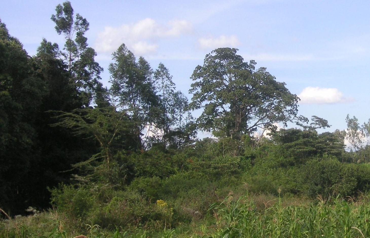
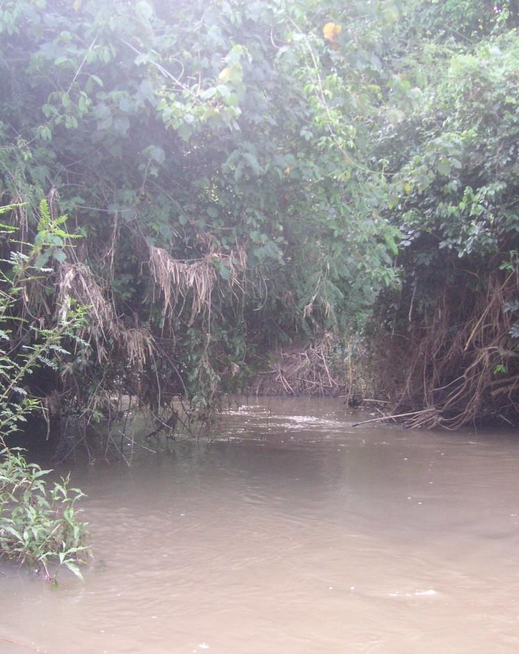
The studied land plot is situated in the semi-arid savannah zone of the Naro Moru sub-catchment at the foot of Mt. Kenya. A small-scale farmer leaves the riparian vegetation undisturbed, which enables the growth of dense bushes. On the one hand, the riparian vegetation contributes to prevent land loss caused by riverbank erosion, on the other hand it is a habitat for the special riparian fauna and flora.
Purpose of the Technology: Despite semi-arid conditions, there is a high probability of flooding. Heavy rainfalls on upper slopes of Mt. Kenya lead to flood events in the semi-arid areas of Naro Moru River. These events have a destructive effect on the riverbanks, which have become instable by human induced activities such as overgrazing and deforestation. The instable riparian soils are eroded easily. The farmers lose their precious land and the water is polluted.
Establishment / maintenance activities and inputs: A good way to overcome the riverbank degradation triggered by high runoff is a passive approach: simply leaving the riparian area undisturbed by human interference. Trees, bushes and grasses stabilize even steep riverbanks with their invading roots. As a result, almost no erosion takes place and infiltration is enhanced during rain events. The riparian microclimate, which is characterized by cooler temperatures during the day and slightly warmer temperatures during the night, is very special compared to the surrounding semi-arid zones. Also water availability is much higher than in the surroundings. Thus, this habitat offers a high biodiversity.
Natural / human environment: The plot is situated on a plateau at the western side of Mt. Kenya. There is not the same amount of precipitation as at the foot slopes of Mt. Kenya. However, the area still benefits from the runoff that is generated on the mountain. Precipitation in the so-called savannah zone ranges from 600mm to 900mm per year. Due to the high evaporation, rain-fed agriculture is only partly possible. Therefore most land users depend on irrigation using river water.
During the last decades, the region has experienced a still continuing population growth which increases population pressure in the area and removal and use of the vegetation along the rivers. The good accessibility and the moderate tourism allow even off-farm income-generation.
2.3 រូបភាពនៃបច្ចេកទេស
វិចិត្រសាលប្រព័ន្ធផ្សព្វផ្សាយ
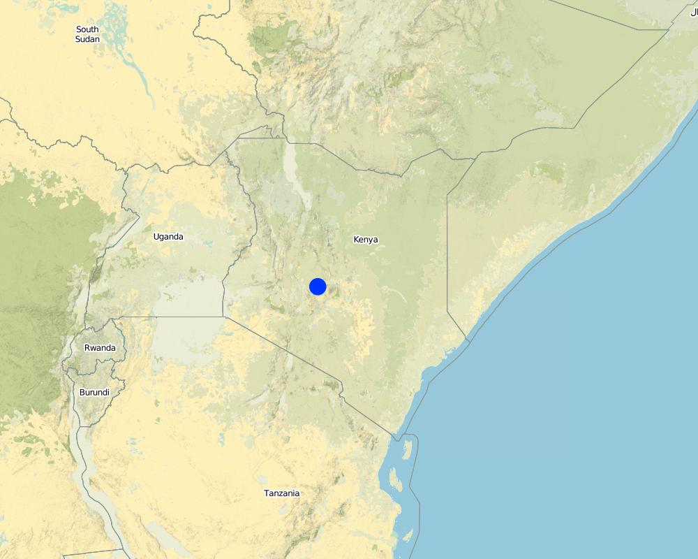
2.5 ប្រទេស/តំបន់/ទីតាំងកន្លែង ដែលបច្ចេកទេសត្រូវបានអនុវត្ត និងបានគ្រប់ដណ្តប់ដោយការវាយតម្លៃនេះ
ប្រទេស:
ប្រទេសកេនយ៉ា
តំបន់/រដ្ឋ/ខេត្ត:
Kenya/Central Province
បញ្ជាក់បន្ថែមពីលក្ខណៈនៃទីតាំង:
Naro Moru
បញ្ជាក់ពីការសាយភាយនៃបច្ចេកទេស:
- ត្រូវបានផ្សព្វផ្សាយត្រឹមតំបន់មួយ
ប្រសិនបើមិនច្បាស់ពីទំហំផ្ទៃដី សូមធ្វើការប៉ាន់ប្រម៉ាណ:
- < 0.1 គម2 (10 ហិកតា)
មតិយោបល់:
The riparian area is very small, thus the whole plot of the farmer is indicated.
Map
×2.6 កាលបរិច្ឆេទនៃការអនុវត្ត
ប្រសិនបើមិនច្បាស់ឆ្នាំ សូមបញ្ជាក់កាលបរិច្ឆេទដែលប្រហាក់ប្រហែល:
- 10-50 ឆ្នាំ
2.7 ការណែនាំពីបច្ចេកទេស
សូមបញ្ជាក់តើបច្ចេកទេសត្រូវបានណែនាំឱ្យអនុវត្តដោយរបៀបណា:
- តាមរយៈការបង្កើតថ្មីរបស់អ្នកប្រើប្រាស់ដី
មតិយោបល់ (ប្រភេទនៃគម្រោង ។ល។):
The farmer has not touched the land since 20 years.
3. ចំណាត់ថ្នាក់នៃបច្ចេកទេស SLM
3.1 គោលបំណងចម្បង (១ ឬច្រើន) នៃបច្ចេកទេសនេះ
- អភិរក្ស/ធ្វើឱ្យប្រសើរឡើងជីវចម្រុះ
- កាត់បន្ថយហានិភ័យនៃគ្រោះមហន្តរាយ
3.2 ប្រភេទដីប្រើប្រាស់មួយប្រភេទ (ច្រើនប្រភេទ) ដែលបានអនុវត្តបច្ចេកទេស

ដីព្រៃ/ដីដាំដើមឈើ
ផលិតផល និងសេវាកម្ម:
- ការអភិរក្ស/ការការពារធម្មជាតិ
- ការពារពីគ្រោះធម្មជាតិ
មតិយោបល់:
Major land use problems (compiler’s opinion): In not treated areas, land users have to fight serious riverbank erosion. Due to steep riverbanks, stabilisation is very tricky.
Major land use problems (land users’ perception): Deforested riverbanks are very difficult to control, land loss is a consequence.
Other type of forest: Protected riparian forest
Problems / comments regarding forest use: The forest is left as protected forest because it stabilizes the riverbank.
Forest products and services: nature conservation / protection, protection against natural hazards
Number of growing seasons per year: 2
Longest growing period in days: 60 Longest growing period from month to month: april to may Second longest growing period in days: 60 Second longest growing period from month to month: october to november
3.5 ក្រុម SLM ដែលបច្ចេកទេសស្ថិតនៅក្នុង
- តំបន់ទ្រនាប់ (បិទការប្រើប្រាស់ គាំទ្រដល់ការស្តារឡើងវិញ)
- ការគ្រប់គ្រងទឹកលើដី (ទឹកធ្លាក់ ទន្លេ បឹង សមុទ្រ)
3.6 វិធានការ SLM ដែលបញ្ចូលនូវបច្ចេកទេស

វិធានការគ្រប់គ្រង
- M5: គ្រប់គ្រង/ ការប្លាស់ប្តូរសមាសភាពពូជ
មតិយោបល់:
Main measures: management measures
3.7 កំណត់ប្រភេទនៃការធ្លាក់ចុះគុណភាពដីសំខាន់ៗដែលបច្ចេកទេសនេះបានដោះស្រាយ

ការហូរច្រោះដីដោយសារទឹក
- Wt: ការបាត់ដីស្រទាប់លើដោយការហូរច្រោះ
- Wr: សំណឹកដីច្រាំងទន្លេ

ការធ្លាក់ចុះជីវសាស្ត្រនៃដី
- Bc: ការថយចុះនូវគម្របរុក្ខជាតិ
- Bh: ការបាត់បង់ទីជំរក
- Bq: ការថយចុះនូវជីវម៉ាស/ បរិមាណ

ការបាត់បង់ទឹក
- Hg: ការប្រែប្រួលបរិមាណទឹកនៅក្រោមដី
- Hp: ការថយចុះគុណភាពទឹកនៅលើផ្ទៃដី
- Hw៖ ការថយចុះសមត្ថភាព buffering របស់តំបន់ដីសើមដែលដោះស្រាយជាមួយនឹងទឹកជំនន់ និងការបំពុល
មតិយោបល់:
Main type of degradation addressed: Wr: riverbank erosion, Hp: decline of surface water quality
Secondary types of degradation addressed: Wt: loss of topsoil / surface erosion, Bc: reduction of vegetation cover, Bh: loss of habitats, Bq: quantity / biomass decline, Hg: change in groundwater / aquifer level, Hw: reduction of the buffering capacity of wetland areas
Main causes of degradation: deforestation / removal of natural vegetation (incl. forest fires), over-exploitation of vegetation for domestic use, overgrazing, floods
Secondary causes of degradation: Heavy / extreme rainfall (intensity/amounts), population pressure, poverty / wealth
3.8 ការពារ កាត់បន្ថយ ឬស្តារឡើងវិញនៃការធ្លាក់ចុះគុណភាពដី
បញ្ជាក់ពីគោលដៅរបស់បច្ចេកទេស ដែលផ្តោតទៅការធ្លាក់ចុះគុណភាពដី:
- ការការពារការធ្លាក់ចុះគុណភាពដី
4. បច្ចេកទេសជាក់លាក់ សកម្មភាពអនុវត្ត ធាតុចូល និងថ្លៃដើម
4.1 គំនូសបច្ចេកទេសនៃបច្ចេកទេសនេះ
លក្ខណៈពិសេសនៃបច្ចេកទេស (ទាក់ទងនឺងគំនូរបច្ចេកទេស):
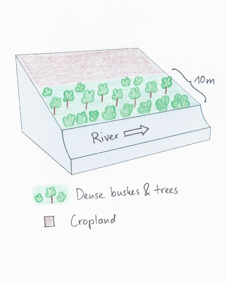
The land user noticed the riverbank erosion problems neighbours had after clearing of the riparian vegetation. This led to the protective approach of natural trees and bushes. Adjacent to the riparian area, crops are cultivated.
Location: Naro Moru. Nyeri / Central Province
Date: 28.12.2013
Technical knowledge required for field staff / advisors: low
Technical knowledge required for land users: low
Main technical functions: stabilisation of soil (eg by tree roots against land slides), increase of infiltration, improvement of water quality, buffering / filtering water, sediment retention / trapping, sediment harvesting
Secondary technical functions: improvement of ground cover, increase of surface roughness, increase / maintain water stored in soil, increase of groundwater level / recharge of groundwater
Control / change of species composition: In the protected area only indigenous tress, bushes and grasses should be present. Especially indigenous trees do not need much water and allow more water to infiltrate into the soil.
ឈ្មោះអ្នកនិពន្ធ:
Manuel Fischer
4.2 ព័ត៌មានទូទៅដែលពាក់ព័ន្ធនឹងការគណនាធាតុចូល និងថ្លៃដើម
កំណត់របៀបនៃការគណនាថ្លៃដើម និងធាតុចូល:
- ក្នុងឯកតាបច្ចេកទេស
បញ្ជាក់ឯកតា:
Riparian area
បញ្ជាក់ពីទំហំនៃឯកតា (បើពាក់ព័ន្ធ):
60 m
ផ្សេងៗ/ រូបិយប័ណ្ណជាតិ (បញ្ជាក់):
Kenyan Shilling
បើពាក់ព័ន្ធសូមកំណត់អត្រាប្តូរប្រាក់ពីដុល្លាទៅរូបិយប័ណ្ណតំបន់ (ឧ. 1 ដុល្លារ = 79.9 រៀលនៃរូបិយប័ណ្ណប្រេស៊ីល) ៖ 1 ដុល្លារ =:
90,0
កំណត់ថ្លៃឈ្នួលជាមធ្យមនៃការជួលកម្លាំងពលកម្មក្នុងមួយថ្ងៃ:
2.70
4.3 សកម្មភាពបង្កើត
| សកម្មភាព | រយៈពេល (រដូវកាល) | |
|---|---|---|
| 1. | No activities were needed |
4.5 សកម្មភាពថែទាំ
| សកម្មភាព | ពេលវេលា/ ភាពញឹកញាប់ | |
|---|---|---|
| 1. | Control of species composition and destruction of invading plants | during rainy season |
4.6 កំណត់ថ្លៃដើមសម្រាប់ការថែទាំ/ សកម្មភាពរបស់បច្ចេកទេស (ក្នុងរយៈពេលមួយឆ្នាំ)
| បញ្ជាក់ពីធាតុចូល | ឯកតា | បរិមាណ | ថ្លៃដើមក្នុងមួយឯកតា | ថ្លៃធាតុចូលសរុប | % នៃថ្លៃដើមដែលចំណាយដោយអ្នកប្រើប្រាស់ដី | |
|---|---|---|---|---|---|---|
| កម្លាំងពលកម្ម | Control of species composition and destruction of invading plants | Persons/day | 2,0 | 3,0 | 6,0 | 100,0 |
| ថ្លៃដើមសរុបសម្រាប់ការថែទាំដំណាំតាមបច្ចេកទេស | 6,0 | |||||
| ថ្លៃដើមសរុបសម្រាប់ការថែទាំដំណាំតាមបច្ចេកទេសគិតជាដុល្លារ | 0,07 | |||||
5. លក្ខណៈបរិស្ថានធម្មជាតិ និងមនុស្ស
5.1 អាកាសធាតុ
បរិមាណទឹកភ្លៀងប្រចាំឆ្នាំ
- < 250 មម
- 251-500 មម
- 501-750 មម
- 751-1,000 មម
- 1,001-1,500 មម
- 1,501-2,000 មម
- 2,001-3,000 មម
- 3,001-4,000 មម
- > 4,000 មម
តំបន់កសិអាកាសធាតុ
- មានភ្លៀងតិចតួច
Thermal climate class: subtropics
5.2 សណ្ឋានដី
ជម្រាលជាមធ្យម:
- រាបស្មើ (0-2%)
- ជម្រាលតិចតួច (3-5%)
- មធ្យម (6-10%)
- ជម្រាលខ្ពស់បន្តិច (11-15%)
- ទីទួល (16-30%)
- ទីទួលចោត (31-60%)
- ទីទួលចោតខ្លាំង (>60%)
ទម្រង់ដី:
- ខ្ពង់រាប
- កំពូលភ្នំ
- ជម្រាលភ្នំ
- ជម្រាលទួល
- ជម្រាលជើងភ្នំ
- បាតជ្រលងភ្នំ
តំបន់តាមរយៈកម្ពស់ :
- 0-100 ម
- 101-500 ម
- 501-1,000 ម
- 1,001-1,500 ម
- 1,501-2,000 ម
- 2,001-2,500 ម
- 2,501-3,000 ម
- 3,001-4,000 ម
- > 4,000 ម
មតិយោបល់ និងបញ្ចាក់បន្ថែមអំពីសណ្ឋានដី :
Altitudinal zone: 1800 m a.s.l.
5.3 ដី
ជម្រៅដីជាមធ្យម:
- រាក់ខ្លាំង (0-20 សម)
- រាក់ (21-50 សម)
- មធ្យម (51-80 សម)
- ជ្រៅ (81-120 សម)
- ជ្រៅខ្លាំង (> 120 សម)
វាយនភាពដី (ស្រទាប់លើ):
- មធ្យម (ល្បាយ, ល្បាប់)
សារធាតុសរីរាង្គនៅស្រទាប់ដីខាងលើ:
- មធ្យម (1-3%)
បើអាចសូមភ្ជាប់ការពណ៌នាពីដីឱ្យបានច្បាស់ ឬព័ត៌មានដែលអាចទទួលបាន ឧ. ប្រភេទដី, pH ដី/ ជាតិអាស៊ីត, សមត្ថភាពផ្លាស់ប្តូរកាចុង, វត្តមាននីត្រូសែន, ភាពប្រៃ ។ល។:
Soil fertility is medium
Soil drainage / infiltration is poor - medium
Soil water storage capacity is low but with mulching it changes to medium
5.4 ទឹកដែលអាចទាញមកប្រើប្រាស់បាន និងគុណភាពទឹក
នីវ៉ូទឹកក្រោមដី:
< 5 ម
ទឹកលើដីដែលអាចទាញយកប្រើប្រាស់បាន:
ល្អ
គុណភាពទឹក (មិនបានធ្វើប្រត្តិកម្ម):
ទឹកពិសារដែលគ្មានគុណភាព (តម្រូវឱ្យមានការសំអាត)
មតិយោបល់ និងលក្ខណៈពិសេសផ្សេងៗទៀតលើគុណភាព និងបរិមាណទឹក :
Ground water table: Just along the river, deeper ground water level 50-100m
5.5 ជីវៈចម្រុះ
ភាពសម្បូរបែបនៃប្រភេទ:
- កម្រិតមធ្យម
5.6 លក្ខណៈនៃអ្នកប្រើប្រាស់ដីដែលអនុវត្តបច្ចេកទេស
ទីផ្សារនៃប្រព័ន្ធផលិតកម្ម:
- សម្រាប់ហូបក្នុងគ្រួសារ (ផ្គត់ផ្គង់ខ្លួនឯង)
ចំណូលក្រៅកសិកម្ម:
- តិចជាង 10% នៃចំណូល
កម្រិតជីវភាព:
- មិនល្អ
ឯកជន ឬក្រុម:
- ធ្វើខ្លួនឯង/ គ្រួសារ
យេនឌ័រ:
- ស្ត្រី
- បុរស
សូមបញ្ជាក់ពីលក្ខណៈពាក់ព័ន្ធផ្សេងទៀតអំពីអ្នកប្រើប្រាស់ដី:
Land users applying the Technology are mainly common / average land users
Population density: 200-500 persons/km2
Off-farm income specification: The farmer has no off-farm income.
5.7 ទំហំផ្ទៃដីជាមធ្យមនៃដីប្រើប្រាស់ដោយអ្នកប្រើប្រាស់ដី ក្នុងការអនុវត្តបច្ចេកទេស
- < 0.5 ហិកតា
- 0.5-1 ហិកតា
- 1-2 ហិកតា
- 2-5 ហិកតា
- 5-15 ហិកតា
- 15-50 ហិកតា
- 50-100 ហិកតា
- 100-500 ហិកតា
- 500-1,000 ហិកតា
- 1,000-10,000 ហិកតា
- > 10,000 ហិកតា
តើផ្ទៃដីនេះចាត់ទុកជាទំហំកម្រិតណាដែរ ខ្នាតតូច មធ្យម ឬខ្នាតធំ (ធៀបនឹងបរិបទតំបន់)?
- ខ្នាតតូច
5.8 ភាពជាម្ចាស់ដី កម្មសិទ្ធប្រើប្រាស់ដី និងកម្មសិទ្ធប្រើប្រាស់ទឹក
ភាពជាម្ចាស់ដី:
- ឯកជន មិនមានកម្មសិទ្ធ
កម្មសិទ្ធិប្រើប្រាស់ដី:
- ឯកជន
កម្មសិទ្ធប្រើប្រាស់ទឹក:
- អាស្រ័យផលសេរី (មិនមានការកំណត់)
- ជាក្រុម (មានដែនកំណត់)
5.9 ការប្រើប្រាស់សេវាកម្ម និងហេដ្ឋារចនាសម្ព័ន្ធ
សុខភាព:
- មិនល្អ
- មធ្យម
- ល្អ
ការអប់រំ:
- មិនល្អ
- មធ្យម
- ល្អ
ជំនួយបច្ចេកទេស:
- មិនល្អ
- មធ្យម
- ល្អ
ការងារ (ឧ. ការងារក្រៅកសិដ្ឋាន):
- មិនល្អ
- មធ្យម
- ល្អ
ទីផ្សារ:
- មិនល្អ
- មធ្យម
- ល្អ
ថាមពល:
- មិនល្អ
- មធ្យម
- ល្អ
ផ្លូវ និងការដឹកជញ្ជូន:
- មិនល្អ
- មធ្យម
- ល្អ
ទឹកផឹក និងអនាម័យ:
- មិនល្អ
- មធ្យម
- ល្អ
សេវាកម្មហិរញ្ញវត្ថុ:
- មិនល្អ
- មធ្យម
- ល្អ
6. ផលប៉ះពាល់ និងការសន្និដ្ឋាន
6.1 ផលប៉ះពាល់ក្នុងបរិវេណអនុវត្តបច្ចេកទេសដែលកើតមាន
ផលប៉ះពាល់លើសេដ្ឋកិច្ចសង្គម
ផលិតផល
ផលិតកម្មឈើ
មតិយោបល់/ ការបញ្ជាក់:
Before the establishment of the technology, the farmer used to prune the trees. He does not do that anymore.
ផលប៉ះពាល់ទៅលើវប្បធម៌សង្គម
ចំណេះដឹង SLM / ការធ្លាក់ចុះគុណភាពដី
aesthetics
Livelihood and human well-being
មតិយោបល់/ ការបញ្ជាក់:
Erosion knowledge was improved
ផលប៉ះពាល់ទៅលើអេកូឡូស៊ី
វដ្តទឹក/លំហូរ
បរិមាណទឹក
គុណភាពទឹក
នីវ៉ូទឹកក្រោមដី/ ដង្ហើមទឹក
ដី
សំណើមដី
គម្របដី
ជីវចម្រុះ៖ ដំណាំ, សត្វ
ភាពសម្បូរបែបនៃរុក្ខជាតិ
ប្រភេទសត្វមានប្រយោជន៍
ភាពសម្បូរបែបនៃទីជំរក
ការកាត់បន្ថយហានិភ័យនៃគ្រោះមហន្តរាយ និងគ្រោះអាកាសធាតុ
ផលប៉ះពាល់នៃគ្រោះរាំងស្ងួត
ផលប៉ះពាល់ទៅលើអេកូឡូស៊ីផ្សេងៗ
Riverbank erosion
6.2 ផលប៉ះពាល់ក្រៅបរិវេណអនុវត្តបច្ចេកទេសដែលកើតមាន
ទឹកដែលអាចទាញមកប្រើប្រាស់បាន
លំហូរទឹកដែលអាចប្រើប្រាស់បាននៅរដូវប្រាំង
កំណកល្បាប់ខ្សែទឹកខាងក្រោម
ទឹកក្រោមដី/ ការបំពុលទឹកទន្លេ
Buffering/សមត្ថភាពចម្រោះ
6.3 ភាពប្រឈម និងភាពរួសនៃបច្ចេកទេសទៅនឹងការប្រែប្រួលអាកាសធាតុ និងគ្រោះអាកាសធាតុ/ គ្រោះមហន្តរាយ (ដែលដឹងដោយអ្នកប្រើប្រាស់ដី)
ការប្រែប្រួលអាកាសធាតុ
ការប្រែប្រួលអាកាសធាតុ
| រដូវកាល | កើនឡើង ឬថយចុះ | លក្ខណៈឆ្លើយតបនៃបច្ចេកទេសទៅនឹងការប្រែប្រួលអាកាសធាតុ | |
|---|---|---|---|
| សីតុណ្ហភាពប្រចាំឆ្នាំ | កើនឡើង | ល្អ |
គ្រោះអាកាសធាតុ (មហន្តរាយ)
គ្រោះមហន្តរាយធម្មជាតិ
| លក្ខណៈឆ្លើយតបនៃបច្ចេកទេសទៅនឹងការប្រែប្រួលអាកាសធាតុ | |
|---|---|
| ព្យុះភ្លៀងតាមតំបន់ | ល្អ |
| ព្យុះកំបុតត្បូងតាមតំបន់ | ល្អ |
គ្រោះមហន្តរាយអាកាសធាតុ
| លក្ខណៈឆ្លើយតបនៃបច្ចេកទេសទៅនឹងការប្រែប្រួលអាកាសធាតុ | |
|---|---|
| រាំងស្ងួត | ល្អ |
គ្រោះមហន្តរាយទឹក
| លក្ខណៈឆ្លើយតបនៃបច្ចេកទេសទៅនឹងការប្រែប្រួលអាកាសធាតុ | |
|---|---|
| ទឹកជំនន់ទូទៅ (ទន្លេ) | ល្អ |
ផលវិបាកដែលទាក់ទងនឹងបរិយាកាសផ្សេងៗទៀត
ផលវិបាកដែលទាក់ទងនឹងបរិយាកាសផ្សេងៗទៀត
| លក្ខណៈឆ្លើយតបនៃបច្ចេកទេសទៅនឹងការប្រែប្រួលអាកាសធាតុ | |
|---|---|
| កាត់បន្ថយពេលដាំដុះ | ល្អ |
6.4 ការវិភាគថ្លៃដើម និងអត្ថប្រយោជន៍
តើផលចំណេញ និងថ្លៃដើមត្រូវបានប្រៀបធៀបគ្នាយ៉ាងដូចម្តេច (ទស្សនៈរបស់អ្នកប្រើប្រាស់ដី)?
រយៈពេលខ្លី:
ប៉ះពាល់តិចតួចបំផុត
រយៈពេលវែង:
វិជ្ជមានតិចតួច
តើផលចំណេញ និងការថែទាំ/ ជួសជុលត្រូវបានប្រៀបធៀបគ្នាយ៉ាងដូចម្តេច (ទស្សនៈរបស់អ្នកប្រើប្រាស់ដី)?
រយៈពេលខ្លី:
ប៉ះពាល់តិចតួចបំផុត
រយៈពេលវែង:
វិជ្ជមានតិចតួច
មតិយោបល់:
There are no establishment costs, that is why the short-term returns ares neutral. After some years, the benefits develop as long-term returns
6.5 ការទទួលយកបច្ចេកទេស
- តែមួយករណី /ពិសោធន៍
ក្នុងចំណោមគ្រួសារទាំងអស់ដែលបានអនុវត្តបច្ចេកទេស តើមានប៉ុន្មានគ្រួសារដែលចង់ធ្វើដោយខ្លួនឯង ដោយមិនទទួលបានសម្ភារៈលើកទឹកចិត្ត/ប្រាក់ឧបត្ថម្ភ?:
- 11-50%
មតិយោបល់:
20% of land user families have adopted the Technology without any external material support
There is a little trend towards spontaneous adoption of the Technology
Comments on adoption trend: There are some farmers who are very convinced. The number of farmers adopting the technology is growing slowly.
6.7 ភាពខ្លាំង/ គុណសម្បត្តិ/ ឱកាសនៃបច្ចេកទេស
| ភាពខ្លាំង/ គុណសម្បត្តិ/ ឱកាសនៅកន្លែងរបស់អ្នកប្រើប្រាស់ដី |
|---|
|
There are no problems with riverbank erosion. How can they be sustained / enhanced? Keep the vegetation cover and do not perform too many activities in the riparian zone. |
| ភាពខ្លាំង/ គុណសម្បត្តិ/ ឱកាស ទស្សនៈរបស់បុគ្គលសំខាន់ៗ |
|---|
|
The technology creates a habitat for the very specific riparian fauna and flora and this boosts biodiversity. How can they be sustained / enhanced? By enlarging the riparian zone. |
6.8 ភាពខ្សោយ/ គុណវិបត្តិ/ ហានិភ័យនៃបច្ចេកទេស និងវិធីសាស្ត្រដោះស្រាយ
| ភាពខ្សោយ/ គុណវិបត្តិ/ ហានិភ័យ ទស្សនៈរបស់អ្នកចងក្រងឬបុគ្គលសំខាន់ៗ | តើបច្ចេកទេសទាំងនោះបានដោះស្រាយបញ្ហាដូចម្តេច? |
|---|---|
| There is no productive use of this technology, therefore it is difficult to convince other farmers to adopt this technology. | Slight use of the riparian brings already good returns of fodder and fuelwood and still allows good protection. |
7. ឯកសារយោង និងវេបសាយ
7.1 វិធីសាស្ត្រ/ ប្រភពនៃព័ត៌មាន
ការតភ្ជាប់ និងម៉ូឌុល
ពង្រីកមើលទាំងអស់ បង្រួមទាំងអស់ការតភ្ជាប់
គ្មានការតភ្ជាប់
ម៉ូឌុល
គ្មានម៉ូឌុល