Natural riparian vegetation to sustain a stable riverbank at Naro Moru River [เคนยา]
- ผู้สร้างสรรค์:
- การอัพเดท:
- ผู้รวบรวม: Manuel Fischer
- ผู้เรียบเรียง: –
- ผู้ตรวจสอบ: David Streiff, Alexandra Gavilano
technologies_1569 - เคนยา
- บทสรุปทั้งหมดในรูปแบบของ PDF
- บทสรุปทั้งหมดในรูปแบบของ PDF เพื่อพิมพ์
- บทสรุปทั้งหมดในรูปหน้าเว็บ
- บทสรุปทั้งหมด (ไม่มีการจัดเรียง)
- Natural riparian vegetation to sustain a stable riverbank at Naro Moru River: 30 มีนาคม 2017 (inactive)
- Natural riparian vegetation to sustain a stable riverbank at Naro Moru River: 30 มีนาคม 2017 (inactive)
- Natural riparian vegetation to sustain a stable riverbank at Naro Moru River: 8 พฤษภาคม 2019 (public)
ดูส่วนย่อย
ขยายทั้งหมด ย่อทั้งหมด1. ข้อมูลทั่วไป
1.2 รายละเอียดที่ติดต่อได้ของผู้รวบรวมและองค์กรที่เกี่ยวข้องในการประเมินและการจัดเตรียมทำเอกสารของเทคโนโลยี
ผู้ใช้ที่ดิน:
Ngunjiri Simon
เคนยา
1.3 เงื่อนไขการใช้ข้อมูลที่ได้บันทึกผ่านทาง WOCAT
ผู้รวบรวมและวิทยากรหลักยอมรับเงื่อนไขเกี่ยวกับการใช้ข้อมูลที่ถูกบันทึกผ่านทาง WOCAT:
ใช่
2. การอธิบายลักษณะของเทคโนโลยี SLM
2.1 การอธิบายแบบสั้น ๆ ของเทคโนโลยี
คำจำกัดความของเทคโนโลยี:
Riverbank erosion and biodiversity decline in the riparian area can be overcome by leaving the natural vegetation undisturbed.
2.2 การอธิบายแบบละเอียดของเทคโนโลยี
คำอธิบาย:
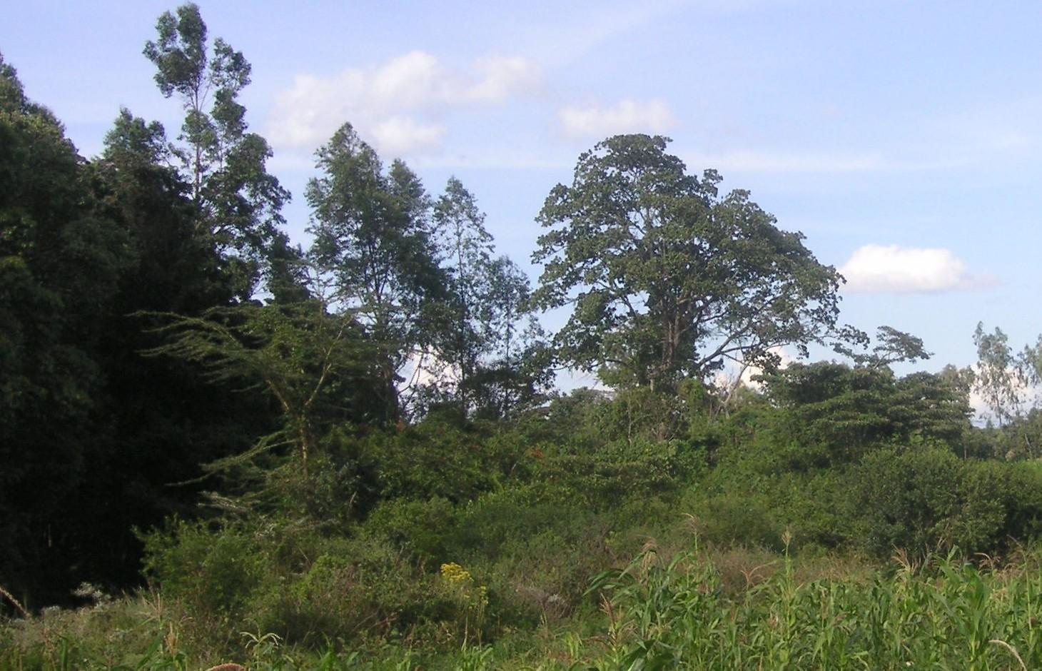
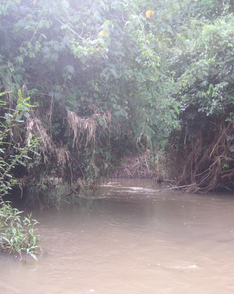
The studied land plot is situated in the semi-arid savannah zone of the Naro Moru sub-catchment at the foot of Mt. Kenya. A small-scale farmer leaves the riparian vegetation undisturbed, which enables the growth of dense bushes. On the one hand, the riparian vegetation contributes to prevent land loss caused by riverbank erosion, on the other hand it is a habitat for the special riparian fauna and flora.
Purpose of the Technology: Despite semi-arid conditions, there is a high probability of flooding. Heavy rainfalls on upper slopes of Mt. Kenya lead to flood events in the semi-arid areas of Naro Moru River. These events have a destructive effect on the riverbanks, which have become instable by human induced activities such as overgrazing and deforestation. The instable riparian soils are eroded easily. The farmers lose their precious land and the water is polluted.
Establishment / maintenance activities and inputs: A good way to overcome the riverbank degradation triggered by high runoff is a passive approach: simply leaving the riparian area undisturbed by human interference. Trees, bushes and grasses stabilize even steep riverbanks with their invading roots. As a result, almost no erosion takes place and infiltration is enhanced during rain events. The riparian microclimate, which is characterized by cooler temperatures during the day and slightly warmer temperatures during the night, is very special compared to the surrounding semi-arid zones. Also water availability is much higher than in the surroundings. Thus, this habitat offers a high biodiversity.
Natural / human environment: The plot is situated on a plateau at the western side of Mt. Kenya. There is not the same amount of precipitation as at the foot slopes of Mt. Kenya. However, the area still benefits from the runoff that is generated on the mountain. Precipitation in the so-called savannah zone ranges from 600mm to 900mm per year. Due to the high evaporation, rain-fed agriculture is only partly possible. Therefore most land users depend on irrigation using river water.
During the last decades, the region has experienced a still continuing population growth which increases population pressure in the area and removal and use of the vegetation along the rivers. The good accessibility and the moderate tourism allow even off-farm income-generation.
2.3 รูปภาพของเทคโนโลยี
อัลบั้มสื่อบันทึก
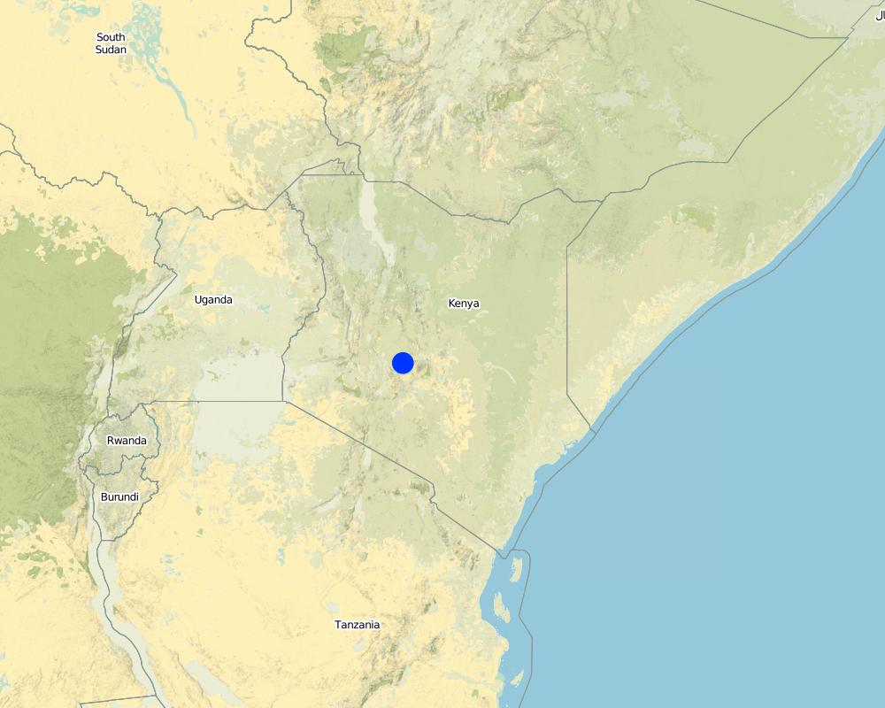
2.5 ประเทศภูมิภาค หรือสถานที่ตั้งที่เทคโนโลยีได้นำไปใช้และได้รับการครอบคลุมโดยการประเมินนี้
ประเทศ:
เคนยา
ภูมิภาค/รัฐ/จังหวัด:
Kenya/Central Province
ข้อมูลจำเพาะเพิ่มเติมของสถานที่ตั้ง :
Naro Moru
ระบุการกระจายตัวของเทคโนโลยี:
- กระจายไปอย่างสม่ำเสมอในพื้นที่
If precise area is not known, indicate approximate area covered:
- < 0.1 ตร.กม.(10 เฮกตาร์)
แสดงความคิดเห็น:
The riparian area is very small, thus the whole plot of the farmer is indicated.
Map
×2.6 วันที่การดำเนินการ
ถ้าไม่รู้ปีที่แน่นอน ให้ระบุวันที่โดยประมาณ:
- 10-50 ปี
2.7 คำแนะนำของเทคโนโลยี
ให้ระบุว่าเทคโนโลยีถูกแนะนำเข้ามาอย่างไร:
- ด้วยการริเริ่มของผู้ใช้ที่ดินเอง
ความคิดเห็น (ประเภทของโครงการ เป็นต้น) :
The farmer has not touched the land since 20 years.
3. การจัดประเภทของเทคโนโลยี SLM
3.1 วัตถุประสงค์หลักของเทคโนโลยี
- รักษาสภาพหรือปรับปรุงความหลากหลายทางชีวภาพ
- ลดความเสี่ยงของภัยพิบัติ
3.2 ประเภทของการใช้ที่ดินในปัจจุบันที่ได้นำเทคโนโลยีไปใช้

ป่า/พื้นที่ทำไม้
ผลิตภัณฑ์และบริการ:
- การอนุรักษ์ / ป้องกันธรรมชาติ
- การป้องกันภัยธรรมชาติ
แสดงความคิดเห็น:
Major land use problems (compiler’s opinion): In not treated areas, land users have to fight serious riverbank erosion. Due to steep riverbanks, stabilisation is very tricky.
Major land use problems (land users’ perception): Deforested riverbanks are very difficult to control, land loss is a consequence.
Other type of forest: Protected riparian forest
Problems / comments regarding forest use: The forest is left as protected forest because it stabilizes the riverbank.
Forest products and services: nature conservation / protection, protection against natural hazards
Number of growing seasons per year: 2
Longest growing period in days: 60 Longest growing period from month to month: april to may Second longest growing period in days: 60 Second longest growing period from month to month: october to november
3.5 กลุ่ม SLM ที่ตรงกับเทคโนโลยีนี้
- การปิดล้อมพื้นที่ (หยุดการใช้ประโยชน์ สนับสนุนการฟื้นฟู)
- การจัดการน้ำผิวดิน (น้ำพุ แม่น้ำทะเลสาบ ทะเล)
3.6 มาตรการ SLM ที่ประกอบกันเป็นเทคโนโลยี

มาตรการอนุรักษ์ด้วยการจัดการ
- M5: การควบคุมหรือการเปลี่ยนแปลงขององค์ประกอบของชนิดพันธุ์
แสดงความคิดเห็น:
Main measures: management measures
3.7 รูปแบบหลักของการเสื่อมโทรมของที่ดินที่ได้รับการแก้ไขโดยเทคโนโลยี

การกัดกร่อนของดินโดยน้ำ
- Wt (Loss of topsoil): การสูญเสียดินชั้นบนหรือการกัดกร่อนที่ผิวดิน
- Wr (Riverbank erosion): การกัดกร่อนริมฝั่งแม่น้ำ

การเสื่อมโทรมของดินทางด้านชีวภาพ
- Bc (Reduction of vegetation cover): การลดลงของจำนวนพืชที่ปกคลุมดิน
- Bh (Loss of habitat): การสูญเสียแหล่งที่อยู่
- Bq (Quantity/biomass decline): การลดลงของปริมาณหรือมวลชีวภาพ

การเสื่อมโทรมของน้ำ
- Hg (Change in groundwater): การเปลี่ยนแปลงของน้ำบาดาลหรือระดับน้ำในแอ่งน้ำบาดาล
- Hp (Decline of surface water quality): การลดลงของคุณภาพน้ำที่ผิวดิน
- Hw (Reduction of the buffering capacity of wetland): การลดลงของความทนทานต่อการเปลี่ยนแปลง ของพื้นที่ชุ่มน้ำ
แสดงความคิดเห็น:
Main type of degradation addressed: Wr: riverbank erosion, Hp: decline of surface water quality
Secondary types of degradation addressed: Wt: loss of topsoil / surface erosion, Bc: reduction of vegetation cover, Bh: loss of habitats, Bq: quantity / biomass decline, Hg: change in groundwater / aquifer level, Hw: reduction of the buffering capacity of wetland areas
Main causes of degradation: deforestation / removal of natural vegetation (incl. forest fires), over-exploitation of vegetation for domestic use, overgrazing, floods
Secondary causes of degradation: Heavy / extreme rainfall (intensity/amounts), population pressure, poverty / wealth
3.8 การป้องกัน การลดลง หรือการฟื้นฟูความเสื่อมโทรมของที่ดิน
ระบุเป้าหมายของเทคโนโลยีกับความเสื่อมโทรมของที่ดิน:
- ป้องกันความเสื่อมโทรมของที่ดิน
4. ข้อมูลจำเพาะด้านเทคนิค กิจกรรมการนำไปปฏิบัติใช้ ปัจจัยนำเข้า และค่าใช้จ่าย
4.1 แบบแปลนทางเทคนิคของเทคโนโลยี
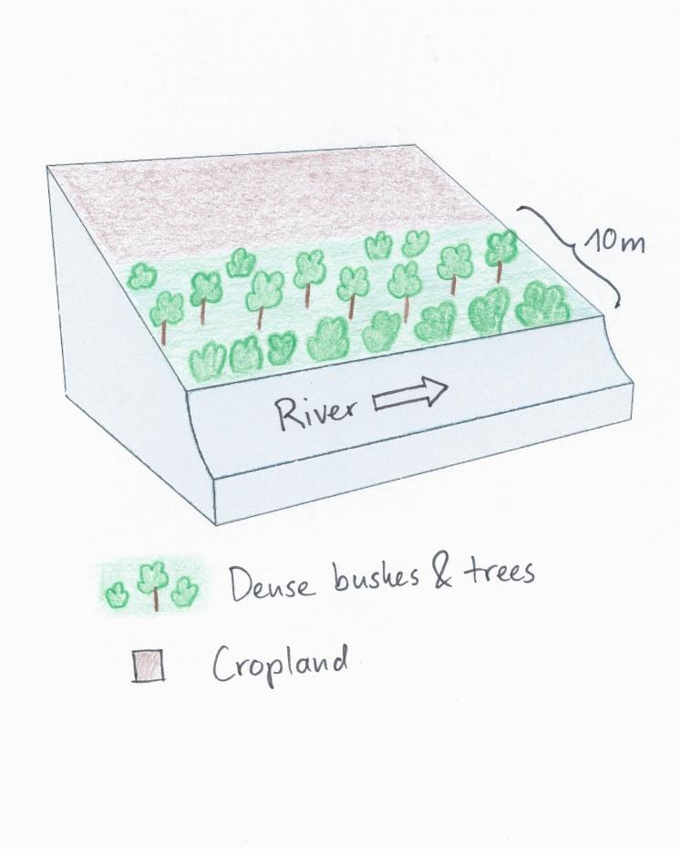
ข้อมูลจำเพาะด้านเทคนิค (แบบแปลนทางเทคนิคของเทคโนโลยี):
The land user noticed the riverbank erosion problems neighbours had after clearing of the riparian vegetation. This led to the protective approach of natural trees and bushes. Adjacent to the riparian area, crops are cultivated.
Location: Naro Moru. Nyeri / Central Province
Date: 28.12.2013
Technical knowledge required for field staff / advisors: low
Technical knowledge required for land users: low
Main technical functions: stabilisation of soil (eg by tree roots against land slides), increase of infiltration, improvement of water quality, buffering / filtering water, sediment retention / trapping, sediment harvesting
Secondary technical functions: improvement of ground cover, increase of surface roughness, increase / maintain water stored in soil, increase of groundwater level / recharge of groundwater
Control / change of species composition: In the protected area only indigenous tress, bushes and grasses should be present. Especially indigenous trees do not need much water and allow more water to infiltrate into the soil.
ผู้เขียน:
Manuel Fischer
4.2 ข้อมูลทั่วไปเกี่ยวกับการคำนวณปัจจัยนำเข้าและค่าใช้จ่าย
ให้ระบุว่าค่าใช้จ่ายและปัจจัยนำเข้าได้รับการคำนวณอย่างไร:
- ต่อหน่วยเทคโนโลยี
โปรดระบุหน่วย:
Riparian area
Specify dimensions of unit (if relevant):
60 m
อื่นๆ หรือสกุลเงินประจำชาติ (ระบุ):
Kenyan Shilling
If relevant, indicate exchange rate from USD to local currency (e.g. 1 USD = 79.9 Brazilian Real): 1 USD =:
90.0
ระบุค่าเฉลี่ยของค่าจ้างในการจ้างแรงงานต่อวัน:
2.70
4.3 กิจกรรมเพื่อการจัดตั้ง
| กิจกรรม | Timing (season) | |
|---|---|---|
| 1. | No activities were needed |
4.5 การบำรุงรักษาสภาพหรือกิจกรรมที่เกิดขึ้นเป็นประจำ
| กิจกรรม | ช่วงระยะเวลา/ความถี่ | |
|---|---|---|
| 1. | Control of species composition and destruction of invading plants | during rainy season |
4.6 ค่าใช้จ่ายของปัจจัยนำเข้าและกิจกรรมที่เกิดขึ้นเป็นประจำที่ต้องการการบำรุงรักษา (ต่อปี)
| ปัจจัยนำเข้า | หน่วย | ปริมาณ | ค่าใช้จ่ายต่อหน่วย | ค่าใช้จ่ายทั้งหมดต่อปัจจัยนำเข้า | %ของค่าใช้จ่ายที่ก่อให้เกิดขึ้นโดยผู้ใช้ที่ดิน | |
|---|---|---|---|---|---|---|
| แรงงาน | Control of species composition and destruction of invading plants | Persons/day | 2.0 | 3.0 | 6.0 | 100.0 |
| ค่าใช้จ่ายทั้งหมดของการบำรุงรักษาสภาพเทคโนโลยี | 6.0 | |||||
| Total costs for maintenance of the Technology in USD | 0.07 | |||||
5. สิ่งแวดล้อมทางธรรมชาติและของมนุษย์
5.1 ภูมิอากาศ
ฝนประจำปี
- < 250 ม.ม.
- 251-500 ม.ม.
- 501-750 ม.ม.
- 751-1,000 ม.ม.
- 1,001-1,500 ม.ม.
- 1,501-2,000 ม.ม.
- 2,001-3,000 ม.ม.
- 3,001-4,000 ม.ม.
- > 4,000 ม.ม.
เขตภูมิอากาศเกษตร
- กึ่งแห้งแล้ง
Thermal climate class: subtropics
5.2 สภาพภูมิประเทศ
ค่าเฉลี่ยความลาดชัน:
- ราบเรียบ (0-2%)
- ลาดที่ไม่ชัน (3-5%)
- ปานกลาง (6-10%)
- เป็นลูกคลื่น (11-15%)
- เป็นเนิน (16-30%)
- ชัน (31-60%)
- ชันมาก (>60%)
ธรณีสัณฐาน:
- ที่ราบสูง/ที่ราบ
- สันเขา
- ไหล่เขา
- ไหล่เนินเขา
- ตีนเนิน
- หุบเขา
ระดับความสูง:
- 0-100 เมตร
- 101-500 เมตร
- 501-1,000 เมตร
- 1,001-1,500 เมตร
- 1,501-2,000 เมตร
- 2,001-2,500 เมตร
- 2,501-3,000 เมตร
- 3,001-4,000 เมตร
- > 4,000 เมตร
ความคิดเห็นและข้อมูลจำเพาะเพิ่มเติมเรื่องสภาพภูมิประเทศ:
Altitudinal zone: 1800 m a.s.l.
5.3 ดิน
ค่าเฉลี่ยความลึกของดิน:
- ตื้นมาก (0-20 ซ.ม.)
- ตื้น (21-50 ซ.ม.)
- ลึกปานกลาง (51-80 ซ.ม.)
- ลึก (81-120 ซ.ม.)
- ลึกมาก (>120 ซ.ม.)
เนื้อดิน (ดินชั้นบน):
- ปานกลาง (ดินร่วน ทรายแป้ง)
อินทรียวัตถุในดิน:
- ปานกลาง (1-3%)
(ถ้ามี) ให้แนบคำอธิบายเรื่องดินแบบเต็มหรือระบุข้อมูลที่มีอยู่ เช่น ชนิดของดิน ค่า pH ของดินหรือความเป็นกรดของดิน ความสามารถในการแลกเปลี่ยนประจุบวก ไนโตรเจน ความเค็ม เป็นต้น:
Soil fertility is medium
Soil drainage / infiltration is poor - medium
Soil water storage capacity is low but with mulching it changes to medium
5.4 ความเป็นประโยชน์และคุณภาพของน้ำ
ระดับน้ำใต้ดิน:
<5 เมตร
น้ำไหลบ่าที่ผิวดิน:
ดี
คุณภาพน้ำ (ที่ยังไม่ได้บำบัด):
เป็นน้ำเพื่อการดื่มที่ไม่ดี (จำเป็นต้องได้รับการบำบัด)
ความคิดเห็นและข้อมูลจำเพาะเพิ่มเติมเรื่องคุณภาพและปริมาณน้ำ:
Ground water table: Just along the river, deeper ground water level 50-100m
5.5 ความหลากหลายทางชีวภาพ
ความหลากหลายทางชนิดพันธุ์:
- ปานกลาง
5.6 ลักษณะของผู้ใช้ที่ดินที่นำเทคโนโลยีไปปฏิบัติใช้
แนวทางการตลาดของระบบการผลิต:
- เพื่อการยังชีพ (หาเลี้ยงตนเอง)
รายได้ที่มาจากนอกฟาร์ม:
- < 10% ของรายได้ทั้งหมด
ระดับของความมั่งคั่งโดยเปรียบเทียบ:
- จน
เป็นรายบุคคล/ครัวเรือน:
- เป็นรายบุคคล/ครัวเรือน
เพศ:
- หญิง
- ชาย
ระบุลักษณะอื่นๆที่เกี่ยวข้องของผู้ใช้ที่ดิน:
Land users applying the Technology are mainly common / average land users
Population density: 200-500 persons/km2
Off-farm income specification: The farmer has no off-farm income.
5.7 Average area of land used by land users applying the Technology
- < 0.5 เฮกตาร์
- 0.5-1 เฮกตาร์
- 1-2 เฮกตาร์
- 2-5 เฮกตาร์
- 5-15 เฮกตาร์
- 15-50 เฮกตาร์
- 50-100 เฮกตาร์
- 100-500 เฮกตาร์
- 500-1,000 เฮกตาร์
- 1,000-10,000 เฮกตาร์
- >10,000 เฮกตาร์
พิจารณาว่าเป็นขนาดเล็ก กลาง หรือขนาดใหญ่ (ซึ่งอ้างอิงถึงบริบทระดับท้องถิ่น):
- ขนาดเล็ก
5.8 กรรมสิทธิ์ในที่ดิน สิทธิในการใช้ที่ดินและสิทธิในการใช้น้ำ
กรรมสิทธิ์ในที่ดิน:
- รายบุคคล ไม่ได้รับสิทธิครอบครอง
สิทธิในการใช้ที่ดิน:
- รายบุคคล
สิทธิในการใช้น้ำ:
- เข้าถึงได้แบบเปิด (ไม่ได้จัดระเบียบ)
- เกี่ยวกับชุมชน (ถูกจัดระเบียบ)
5.9 การเข้าถึงบริการและโครงสร้างพื้นฐาน
สุขภาพ:
- จน
- ปานกลาง
- ดี
การศึกษา:
- จน
- ปานกลาง
- ดี
ความช่วยเหลือทางด้านเทคนิค:
- จน
- ปานกลาง
- ดี
การจ้างงาน (เช่น ภายนอกฟาร์ม):
- จน
- ปานกลาง
- ดี
ตลาด:
- จน
- ปานกลาง
- ดี
พลังงาน:
- จน
- ปานกลาง
- ดี
ถนนและการขนส่ง:
- จน
- ปานกลาง
- ดี
น้ำดื่มและการสุขาภิบาล:
- จน
- ปานกลาง
- ดี
บริการด้านการเงิน:
- จน
- ปานกลาง
- ดี
6. ผลกระทบและสรุปคำบอกกล่าว
6.1 ผลกระทบในพื้นที่ดำเนินการ (On-site) จากการใช้เทคโนโลยี
ผลกระทบทางด้านเศรษฐกิจและสังคม
การผลิต
การผลิตไม้
แสดงความคิดเห็น/ระบุ:
Before the establishment of the technology, the farmer used to prune the trees. He does not do that anymore.
ผลกระทบด้านสังคมวัฒนธรรมอื่น ๆ
SLM หรือความรู้เรื่องความเสื่อมโทรมของที่ดิน
aesthetics
Livelihood and human well-being
แสดงความคิดเห็น/ระบุ:
Erosion knowledge was improved
ผลกระทบด้านนิเวศวิทยา
วัฐจักรน้ำหรือน้ำบ่า
ปริมาณน้ำ
คุณภาพน้ำ
น้ำบาดาลหรือระดับน้ำในแอ่งน้ำบาดาล
ดิน
ความชื้นในดิน
สิ่งปกคลุมดิน
ความหลากหลายทางชีวภาพของพืชและสัตว์
ความหลากหลายทางชีวภาพของพืช
ชนิดพันธุ์ที่ให้ประโยชน์
ความหลากหลายของสัตว์
ลดความเสี่ยงของภัยพิบัติ
ผลกระทบจากภัยแล้ง
ผลกระทบด้านนิเวศวิทยาอื่น ๆ
Riverbank erosion
6.2 ผลกระทบนอกพื้นที่ดำเนินการ (Off-site) จากการใช้เทคโนโลยี
น้ำที่ใช้ประโยชน์ได้
การไหลของน้ำคงที่และสม่ำเสมอในช่วงฤดูแล้ง
การทับถมของดินตะกอนพื้นที่ท้ายน้ำ
การเกิดมลพิษในน้ำบาดาลหรือแม่น้ำ
ความสามารถต้านทานการเปลี่ยนแปลง / ความสามารถในการคัดกรอง
6.3 การเผชิญและความตอบสนองของเทคโนโลยีต่อการเปลี่ยนแปลงสภาพภูมิอากาศที่ค่อยเป็นค่อยไป และสภาพรุนแรงของภูมิอากาศ / ภัยพิบัติ (ที่รับรู้ได้โดยผู้ใช้ที่ดิน)
การเปลี่ยนแปลงสภาพภูมิอากาศที่ค่อยเป็นค่อยไป
การเปลี่ยนแปลงสภาพภูมิอากาศที่ค่อยเป็นค่อยไป
| ฤดู | increase or decrease | เทคโนโลยีมีวิธีการรับมืออย่างไร | |
|---|---|---|---|
| อุณหภูมิประจำปี | เพิ่มขึ้น | ดี |
สภาพรุนแรงของภูมิอากาศ (ภัยพิบัติ)
ภัยพิบัติทางอุตุนิยมวิทยา
| เทคโนโลยีมีวิธีการรับมืออย่างไร | |
|---|---|
| พายุฝนประจำท้องถิ่น | ดี |
| พายุลมประจำท้องถิ่น | ดี |
ภัยพิบัติจากสภาพภูมิอากาศ
| เทคโนโลยีมีวิธีการรับมืออย่างไร | |
|---|---|
| ภัยจากฝนแล้ง | ดี |
ภัยพิบัติจากน้ำ
| เทคโนโลยีมีวิธีการรับมืออย่างไร | |
|---|---|
| น้ำท่วมตามปกติ (แม่น้ำ) | ดี |
ผลลัพธ์ตามมาที่เกี่ยวข้องกับภูมิอากาศอื่น ๆ
ผลลัพธ์ตามมาที่เกี่ยวข้องกับภูมิอากาศอื่น ๆ
| เทคโนโลยีมีวิธีการรับมืออย่างไร | |
|---|---|
| ช่วงการปลูกพืชที่ลดลงมา | ดี |
6.4 การวิเคราะห์ค่าใช้จ่ายและผลประโยชน์ที่ได้รับ
ผลประโยชน์ที่ได้รับเปรียบเทียบกับค่าใช้จ่ายในการจัดตั้งเป็นอย่างไร (จากมุมมองของผู้ใช้ที่ดิน)
ผลตอบแทนระยะสั้น:
เป็นกลางหรือสมดุล
ผลตอบแทนระยะยาว:
ด้านบวกเล็กน้อย
ผลประโยชน์ที่ได้รับเปรียบเทียบกับค่าใช้จ่ายในการบำรุงรักษาหรือต้นทุนที่เกิดขึ้นซ้ำอีก เป็นอย่างไร (จากมุมมองของผู้ใช้ที่ดิน)
ผลตอบแทนระยะสั้น:
เป็นกลางหรือสมดุล
ผลตอบแทนระยะยาว:
ด้านบวกเล็กน้อย
แสดงความคิดเห็น:
There are no establishment costs, that is why the short-term returns ares neutral. After some years, the benefits develop as long-term returns
6.5 การปรับตัวของเทคโนโลยี
- ครั้งเดียวหรือเป็นการทดลอง
Of all those who have adopted the Technology, how many did so spontaneously, i.e. without receiving any material incentives/ payments?
- 11-50%
แสดงความคิดเห็น:
20% of land user families have adopted the Technology without any external material support
There is a little trend towards spontaneous adoption of the Technology
Comments on adoption trend: There are some farmers who are very convinced. The number of farmers adopting the technology is growing slowly.
6.7 จุดแข็ง / ข้อได้เปรียบ / โอกาสของเทคโนโลยี
| จุดแข็ง / ข้อได้เปรียบ / โอกาสในทัศนคติของผู้ใช้ที่ดิน |
|---|
|
There are no problems with riverbank erosion. How can they be sustained / enhanced? Keep the vegetation cover and do not perform too many activities in the riparian zone. |
| จุดแข็ง / ข้อได้เปรียบ / โอกาสในทัศนคติของผู้รวบรวมหรือวิทยากรหลัก |
|---|
|
The technology creates a habitat for the very specific riparian fauna and flora and this boosts biodiversity. How can they be sustained / enhanced? By enlarging the riparian zone. |
6.8 จุดอ่อน / ข้อเสียเปรียบ / ความเสี่ยงของเทคโนโลยีและวิธีการแก้ไข
| จุดอ่อน / ข้อเสียเปรียบ / ความเสี่ยงในทัศนคติของผู้รวบรวมหรือวิทยากรหลัก | มีวิธีการแก้ไขได้อย่างไร |
|---|---|
| There is no productive use of this technology, therefore it is difficult to convince other farmers to adopt this technology. | Slight use of the riparian brings already good returns of fodder and fuelwood and still allows good protection. |
7. การอ้างอิงและการเชื่อมต่อ
7.1 วิธีการและแหล่งข้อมูล
ลิงก์และโมดูล
ขยายทั้งหมด ย่อทั้งหมดลิงก์
ไม่มีลิงก์
โมดูล
ไม่มีโมดูล