Grassed waterways [ប្រទេសន័រវែស]
- ការបង្កើត៖
- បច្ចុប្បន្នភាព
- អ្នកចងក្រង៖ Dominika Krzeminska
- អ្នកកែសម្រួល៖ Lillian Øygarden
- អ្នកត្រួតពិនិត្យច្រើនទៀត៖ Rima Mekdaschi Studer, William Critchley, Tatenda Lemann
Grasdekte vannveier
technologies_6169 - ប្រទេសន័រវែស
ពិនិត្យមើលគ្រប់ផ្នែក
ពង្រីកមើលទាំងអស់ បង្រួមទាំងអស់1. ព័ត៌មានទូទៅ
1.2 ព័ត៌មានលម្អិតពីបុគ្គលសំខាន់ៗ និងស្ថាប័នដែលចូលរួមក្នុងការវាយតម្លៃ និងចងក្រងឯកសារនៃបច្ចេកទេស
អ្នកជំនាញឯកទេស SLM:
អ្នកជំនាញឯកទេស SLM:
ឈ្មោះគម្រោងដែលបានចងក្រងឯកសារ/ វាយតម្លៃលើបច្ចេកទេស (បើទាក់ទង)
OPtimal strategies to retAIN and re-use water and nutrients in small agricultural catchments across different soil-climatic regions in Europe (OPTAIN)ឈ្មោះអង្គភាពមួយ (ច្រើន) ដែលបានចងក្រងឯកសារ/ វាយតម្លៃបច្ចេកទេស (បើទាក់ទង)
Norwegian Institute of Bioeconomy Research (NIBIO) - ប្រទេសន័រវែស1.3 លក្ខខណ្ឌទាក់ទងទៅនឹងការប្រើប្រាស់ទិន្នន័យដែលបានចងក្រងតាមរយៈ វ៉ូខេត
អ្នកចងក្រង និង(បុគ្គលសំខាន់ៗ)យល់ព្រមទទួលយកនូវលក្ខខណ្ឌនានាទាក់ទងទៅនឹងការប្រើប្រាស់ទិន្នន័យដែលបានចងក្រងតាមរយៈវ៉ូខេត:
បាទ/ចា៎
1.4 សេចក្តីប្រកាសស្តីពីចីរភាពនៃការពណ៌នាពីបច្ចេកទេស
តើបច្ចេកទេសដែលបានពណ៌នានេះមានបញ្ហាដែលផ្តោតលើការធ្លាក់ចុះគុណភាពដី, បើដូច្នេះវាមិនអាចត្រូវបានប្រកាសថាជាបច្ចេកទេសនៃការគ្រប់គ្រងប្រកបដោយចីរភាពទេ?
ទេ
1.5 ការយោងទៅលើកម្រងបញ្ជីសំណួរ (មួយ ឬច្រើន) នៃវិធីសាស្ត្រផ្សព្វផ្សាយ SLM (ដែលបានចងក្រងដោយទស្សនៈពិភពលោកស្តីពីវិធីសាស្ត្រ និងបច្ចេកទេសងអភិរក្ស WOCAT)

Regional Environmental program [ប្រទេសន័រវែស]
Regulations and financial grants for reduction of pollution and promotion of the cultural landscape.
- អ្នកចងក្រង៖ Kamilla Skaalsveen
2. ការពណ៌នាពីបច្ចេកទេស SLM
2.1 ការពណ៌នាដោយសង្ខេបពីបច្ចេកទេស
និយមន័យបច្ចេកទេស:
Grassed waterways are shallow channels (natural or constructed) with grass cover, used to drain surface runoff from cropland and prevent erosion.
2.2 ការពណ៌នាលម្អិតពីបច្ចេកទេស
ការពណ៌នា:
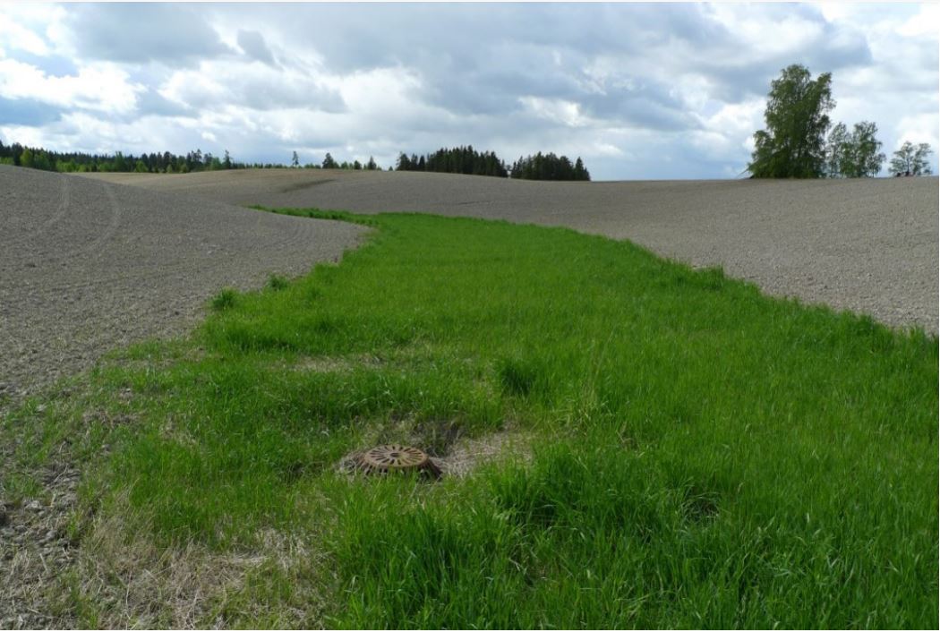
In this documentation we focus on the grassed waterways as a measure to carry surface water down the slope without causing soil erosion. The overland flow can be concentrated in topographic depressions, "thalwegs" in the field. Concentrated runoff in such watercourses can create small rills or even gullies. Vegetation/grass disrupt the water flow, but more importantly to protect the soil from erosive forces.
Purpose/aim: Grassed waterways are important conservation measures managing concentrated flow, especially in agricultural areas: runoff concentrates over grassed areas rather than on bare erodible soil (after tillage). They are intended to reduce runoff velocity and soil erosion by grass roots binding the soil. They also help to enhance infiltration, filtering runoff and contribute to sediment and nutrient deposition.
Establishment/maintenance: Grassed waterways are commonly used in areas where waterways are especially erosion-prone. They are normally sited downslope along natural depressions leading water away from agricultural fields. To control surface runoff, grassed waterways are often combined with inlets for surface water leading runoff to drainage pipes.
According to Regional Environmental Programme (RMP) in Norway, permanent grass cover in topographical depressions should be at least 6 m wide. Grass should be sown in the spring to ensure that it is well established in autumn. The choice of grass species depend on whether there is intention of (for example) using the grass for fodder. The grass can be fertilized or treated by herbicides, since they are located inside the production area. The grass can be harvested to maintain land area for food production and reduce nutrient leakage to the watercourse. Area can be tilled only when renewing the grass cover.
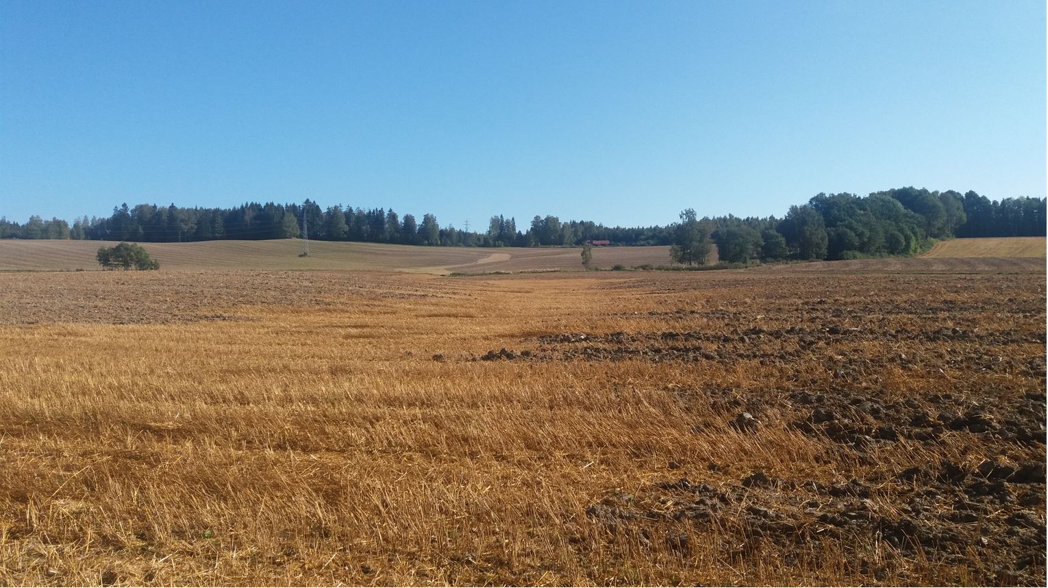
An alternative to grassed waterways is to leave the natural waterways covered in stubble over winter (i.e. unploughed). This measure reduces erosion but will not be as effective as grass cover and will not have the same effect on uptake of nutrients as grass cover waterways, as stubble is dead material.
Efficiency /Impact: The effect of (any) vegetation zones depend on several factors such as the flow properties and the characteristics of the vegetative surface. Significant flow properties are velocity (and hence the slope gradient) and water volume, the particle size and concentration of the sediment in the runoff, and duration and intensity of precipitation. For Norwegian conditions there is also the effect of frozen or unfrozen soil and intensity of snowmelt influence on runoff (surface runoff and infiltration).
Studies of Norwegian conditions indicate that the most relevant factor for function of the vegetation zone is the character of the vegetation (height, robustness, and density), rather than the type of vegetation (Blankenberg & Hougsrud 2010). As the efficiency of vegetation comprises a variety of factors, the implementation of the measures is to a large degree site-specific (Kværnø & Stolte 2012).
The effect of grassed waterways on soil loss has been documented in only a few studies. In Norway, only one study examined the effect of grassed waterways in a small agricultural catchment (26.8 daa or 2.68 ha) in Romerike (Akershus, Viken) and it showed 55% reduction of soil loss (average from 8 years) after implementation of grassed waterways.
Natural / human environment: The information about the technology is based on investigations and/or reports from different part of Norway.
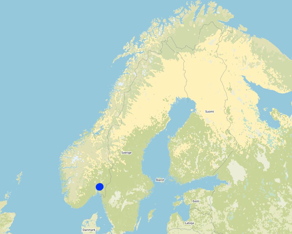
For the purpose of OPTAIN project (https://www.optain.eu/), the technology is further presented in the natural and human environment context of the Kråkstad River catchment - a Norwegian Case Study catchment within OPTAIN project.
The Kråkstad River is mainly situated in Ski municipality in South-Eastern parts of Norway. The river catchment is a western tributary of the Vansjø-Hobøl watercourse, also known as the Morsa watercourse. The Kråkstad River catchment area is c.a 51 km², 43% of which is agricultural land, where mostly cereals are produced on heavy clays soils. The main environmental challenge in the area is water quality (incl. high phosphorus pollution) and soil erosion (incl. riverbank erosion and quick-clay landslides).The Morsa watercourse is a drinking water resource and there are specific environmental regulations for land management followed by subsidies through the Regional Environmental Programme (RMP).
2.3 រូបភាពនៃបច្ចេកទេស
វិចិត្រសាលប្រព័ន្ធផ្សព្វផ្សាយ

2.5 ប្រទេស/តំបន់/ទីតាំងកន្លែង ដែលបច្ចេកទេសត្រូវបានអនុវត្ត និងបានគ្រប់ដណ្តប់ដោយការវាយតម្លៃនេះ
ប្រទេស:
ប្រទេសន័រវែស
តំបន់/រដ្ឋ/ខេត្ត:
Viken county
បញ្ជាក់បន្ថែមពីលក្ខណៈនៃទីតាំង:
The Vansjø-Hobøl catchment
បញ្ជាក់ពីការសាយភាយនៃបច្ចេកទេស:
- ត្រូវបានផ្សព្វផ្សាយត្រឹមតំបន់មួយ
ប្រសិនបើមិនច្បាស់ពីទំហំផ្ទៃដី សូមធ្វើការប៉ាន់ប្រម៉ាណ:
- 0.1-1 គម2
តើបច្ចេកទេស (មួយ ឬច្រើន) ទាំងនោះស្ថិតនៅក្នុងតំបន់ការពារជាអចិន្ត្រៃយ៍ណាមួយដែរឬទេ?
ទេ
Map
×2.6 កាលបរិច្ឆេទនៃការអនុវត្ត
ប្រសិនបើមិនច្បាស់ឆ្នាំ សូមបញ្ជាក់កាលបរិច្ឆេទដែលប្រហាក់ប្រហែល:
- 10-50 ឆ្នាំ
2.7 ការណែនាំពីបច្ចេកទេស
សូមបញ្ជាក់តើបច្ចេកទេសត្រូវបានណែនាំឱ្យអនុវត្តដោយរបៀបណា:
- តាមរយៈគម្រោង / អន្តរាគមន៍ពីខាងក្រៅ
- Regional Environmental Programme (RMP)
មតិយោបល់ (ប្រភេទនៃគម្រោង ។ល។):
Grassed waterways are measures eligible for subsidies in the Regional Environmental Programme (RMP).
3. ចំណាត់ថ្នាក់នៃបច្ចេកទេស SLM
3.1 គោលបំណងចម្បង (១ ឬច្រើន) នៃបច្ចេកទេសនេះ
- កាត់បន្ថយ, បង្ការ, ស្តារឡើងវិញនូវការធ្លាក់ចុះគុណភាពដី
- ការពារតំបន់ទីជម្រាល/តំបន់ខ្សែទឹកខាងក្រោមបញ្ចូលជាមួយបច្ចេកទេសផ្សេងទៀត
- បន្ស៊ាំទៅនឹងការប្រែប្រួលអាកាសធាតុ/គ្រោះមហន្តរាយ និងផលប៉ះពាល់របស់វា
3.2 ប្រភេទដីប្រើប្រាស់មួយប្រភេទ (ច្រើនប្រភេទ) ដែលបានអនុវត្តបច្ចេកទេស
ដីប្រើប្រាស់ចម្រុះនៅលើដីតែមួយ:
ទេ

ដីដាំដំណាំ
- ដំណាំប្រចាំឆ្នាំ
ដំណាំប្រចាំឆ្នាំ - បញ្ជាក់ប្រភេទដំណាំ:
- ធញ្ញជាតិ - ផ្សេងៗ
- small grains
ចំនួនសារដែលដាំដំណាំក្នុងមួយឆ្នាំ:
- 1

ដីព្រៃ/ដីដាំដើមឈើ
- natural forest

ផ្លូវទឹក ផ្ទៃទឹក ដីសើម
- ខ្សែទឹក ផ្លូវទឹក
3.3 បន្ទាប់ពីអនុវត្តបច្ចេកទេស តើដីប្រើប្រាស់មានការប្រែប្រួលដែររឺទេ?
បន្ទាប់ពីអនុវត្តបច្ចេកទេស តើដីប្រើប្រាស់មានការប្រែប្រួលដែររឺទេ?
- ទេ (បន្តទៅសំណួរ 3.4)
3.4 ការផ្គត់ផ្គង់ទឹក
ការផ្គត់ផ្គង់ទឹកនៅកន្លែងអនុវត្តបច្ចេកទេស:
- ទឹកភ្លៀង
3.5 ក្រុម SLM ដែលបច្ចេកទេសស្ថិតនៅក្នុង
- ធ្វើឱ្យប្រសើរឡើងគម្របដី/ ដំណាំគម្របដី
- វិធានការអនុវត្តកាត់ទទឹងទីជម្រាល
- ការបែងចែកទឹក និងប្រព័ន្ធបង្ហូរ
3.6 វិធានការ SLM ដែលបញ្ចូលនូវបច្ចេកទេស

វិធានការរុក្ខជាតិ
- V2: ស្មៅនិងរុក្ខជាតិៗដែលដុះមានអាយុមិនលើសពី 2ឆ្នាំ
3.7 កំណត់ប្រភេទនៃការធ្លាក់ចុះគុណភាពដីសំខាន់ៗដែលបច្ចេកទេសនេះបានដោះស្រាយ

ការហូរច្រោះដីដោយសារទឹក
- Wt: ការបាត់ដីស្រទាប់លើដោយការហូរច្រោះ
- Wg: ការកកើតឡើងនូវកំទេចកំទីដីស្រទាប់ក្រោម

ការបាត់បង់ទឹក
- Hp: ការថយចុះគុណភាពទឹកនៅលើផ្ទៃដី
3.8 ការពារ កាត់បន្ថយ ឬស្តារឡើងវិញនៃការធ្លាក់ចុះគុណភាពដី
បញ្ជាក់ពីគោលដៅរបស់បច្ចេកទេស ដែលផ្តោតទៅការធ្លាក់ចុះគុណភាពដី:
- ការការពារការធ្លាក់ចុះគុណភាពដី
- ការកាត់បន្ថយការធ្លាក់ចុះគុណភាពដី
4. បច្ចេកទេសជាក់លាក់ សកម្មភាពអនុវត្ត ធាតុចូល និងថ្លៃដើម
4.1 គំនូសបច្ចេកទេសនៃបច្ចេកទេសនេះ
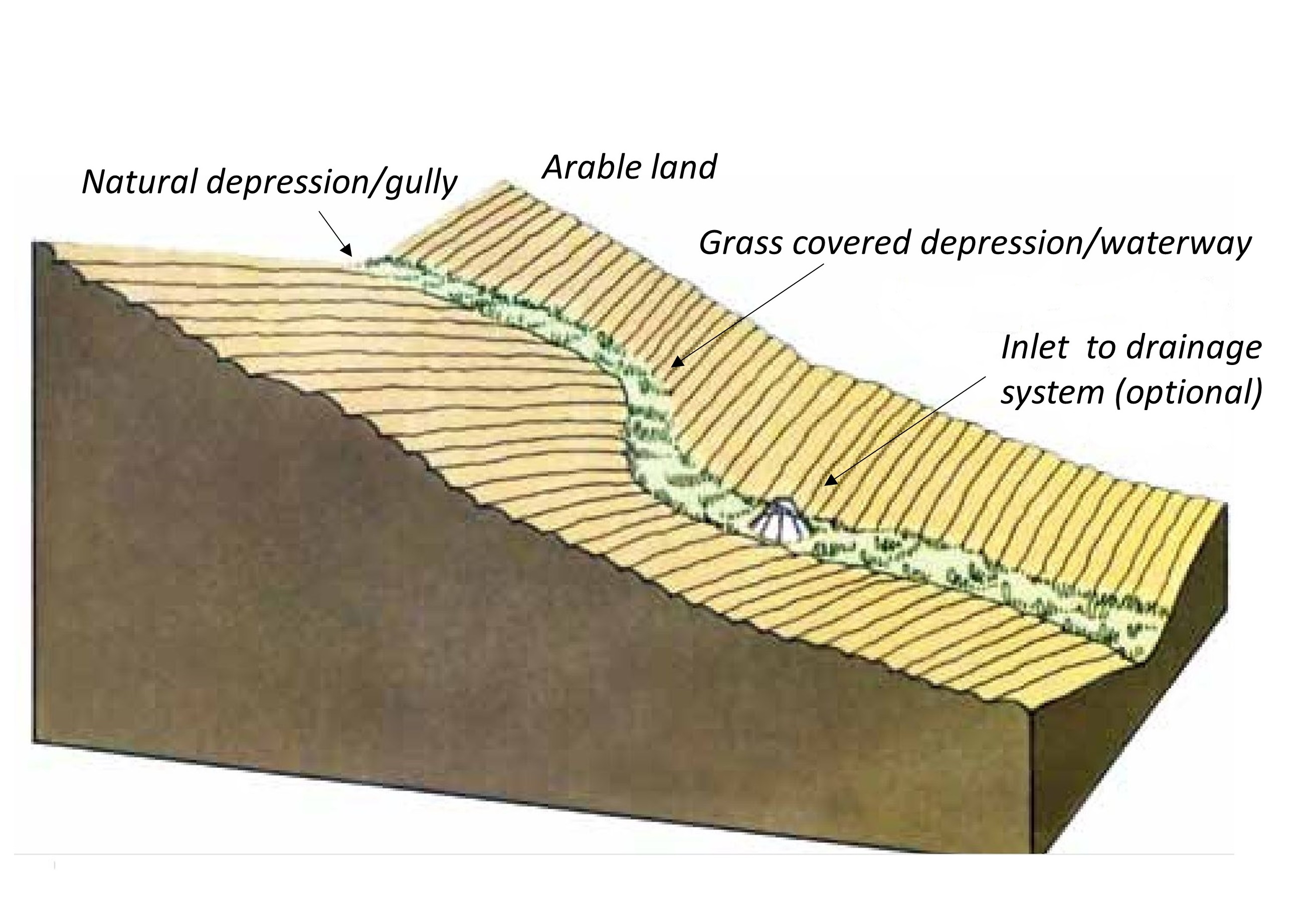
លក្ខណៈពិសេសនៃបច្ចេកទេស (ទាក់ទងនឺងគំនូរបច្ចេកទេស):
Grassed waterways in topographic depressions in the field
ឈ្មោះអ្នកនិពន្ធ:
Lillian Øygarden
4.2 ព័ត៌មានទូទៅដែលពាក់ព័ន្ធនឹងការគណនាធាតុចូល និងថ្លៃដើម
កំណត់របៀបនៃការគណនាថ្លៃដើម និងធាតុចូល:
- ក្នុងឯកតាបច្ចេកទេស
បញ្ជាក់ឯកតា:
length of grassed waterways
បញ្ជាក់ពីទំហំនៃឯកតា (បើពាក់ព័ន្ធ):
meters
ផ្សេងៗ/ រូបិយប័ណ្ណជាតិ (បញ្ជាក់):
NOK
បើពាក់ព័ន្ធសូមកំណត់អត្រាប្តូរប្រាក់ពីដុល្លាទៅរូបិយប័ណ្ណតំបន់ (ឧ. 1 ដុល្លារ = 79.9 រៀលនៃរូបិយប័ណ្ណប្រេស៊ីល) ៖ 1 ដុល្លារ =:
8,99
កំណត់ថ្លៃឈ្នួលជាមធ្យមនៃការជួលកម្លាំងពលកម្មក្នុងមួយថ្ងៃ:
c.a. 3000 NOK (it is only the cost of the time assuming 8h work per day, 320-500 NOK/hour/ person. Machinery, equipment, materials not included)
4.3 សកម្មភាពបង្កើត
| សកម្មភាព | រយៈពេល (រដូវកាល) | |
|---|---|---|
| 1. | Plowing | before sowing |
| 2. | Harrowing | before sowing |
| 3. | Sowing grass | in spring |
4.4 ថ្លៃដើម និងធាតុចូលដែលត្រូវការសម្រាប់ការបង្កើតបច្ចេកទេស
ប្រសិនបើអ្នកប្រើប្រាស់ដីមិនមានថ្លៃដើម 100% សូមបញ្ជាក់ថានរណាដែលចំណាយថ្លៃដើមដែលនៅសល់:
Grassed waterways are eligible for subsidies in Regional Environmental Programme (RMP)
មតិយោបល់:
The costs of establishment and management of grassed waterways are connected to sowing the area and reduced area for cereal production (in case of cereal production farm). The subsidies should be a compensation for such costs. Costs are extremely varied so no estimate is relevant here.
Within RMP for 2019-2022 the subsidy level for maintaining grassed waterways was at the level of 30 kr/m in Viken region.
4.5 សកម្មភាពថែទាំ
| សកម្មភាព | ពេលវេលា/ ភាពញឹកញាប់ | |
|---|---|---|
| 1. | Harvesting grass | 2-3 times/yr |
| 2. | Plowing | In case the re-establishment is needed |
| 3. | Harrowing | In case the re-establishment is needed |
| 4. | Sowing grass | In case the re-establishment is needed |
មតិយោបល់:
Grassed waterways are supposed to exist for several years. The grass can be harvested each year (1- 3 times /year) but plowing, harvesting and sowing is only done when the waterway is established or re established.
4.6 កំណត់ថ្លៃដើមសម្រាប់ការថែទាំ/ សកម្មភាពរបស់បច្ចេកទេស (ក្នុងរយៈពេលមួយឆ្នាំ)
ប្រសិនបើអ្នកប្រើប្រាស់ដីមិនមានថ្លៃដើម 100% សូមបញ្ជាក់ថានរណាដែលចំណាយថ្លៃដើមដែលនៅសល់:
Grassed waterways is a measure eligible for subsidies in Regional Environmental Programme (RMP).
មតិយោបល់:
The costs of establishment and management of grassed waterways are connected to sowing the area and reduced area for cereal production (in case of cereal production farm). There is no general rule for harvesting. However, if farmers harvest the grass they can get the income. If the grass is not harvested then the production area is reduced. The subsidies should be a compensation for such costs.
Within RMP for 2019-2022 the subside level for maintaining grassed waterways was at the level of 30 kr/m in Viken region.
4.7 កត្តាសំខាន់បំផុតដែលមានឥទ្ធិពលដល់ការចំណាយ
ពណ៌នាពីកត្តាប៉ះពាល់ចម្បងៗទៅលើថ្លៃដើម:
The costs of establishment and management of grassed waterways are connected to sowing the area and reduced area for cereal production (in case of cereal production farm). There is no general rule for harvesting. However, if farmers harvest the grass they can get the income. If the grass is not harvested then the production area is reduced. The subsidies should be a compensation for such costs.
The cost of the area management is dependent on:
- Location (priority areas)
- Type of grass
- Possibility to use the grass as a fodder
Grassed waterways are eligible for subsidies in Regional Environmental Programme (RMP).
Within RMP for 2019-2022 the subside level for maintaining grassed waterways was at the level of 30 kr/m in Viken region.
5. លក្ខណៈបរិស្ថានធម្មជាតិ និងមនុស្ស
5.1 អាកាសធាតុ
បរិមាណទឹកភ្លៀងប្រចាំឆ្នាំ
- < 250 មម
- 251-500 មម
- 501-750 មម
- 751-1,000 មម
- 1,001-1,500 មម
- 1,501-2,000 មម
- 2,001-3,000 មម
- 3,001-4,000 មម
- > 4,000 មម
តំបន់កសិអាកាសធាតុ
- មានភ្លៀងមធ្យម
- មានភ្លៀងតិចតួច
Thermal climate class: temperate
Thermal climate class: boreal
5.2 សណ្ឋានដី
ជម្រាលជាមធ្យម:
- រាបស្មើ (0-2%)
- ជម្រាលតិចតួច (3-5%)
- មធ្យម (6-10%)
- ជម្រាលខ្ពស់បន្តិច (11-15%)
- ទីទួល (16-30%)
- ទីទួលចោត (31-60%)
- ទីទួលចោតខ្លាំង (>60%)
ទម្រង់ដី:
- ខ្ពង់រាប
- កំពូលភ្នំ
- ជម្រាលភ្នំ
- ជម្រាលទួល
- ជម្រាលជើងភ្នំ
- បាតជ្រលងភ្នំ
តំបន់តាមរយៈកម្ពស់ :
- 0-100 ម
- 101-500 ម
- 501-1,000 ម
- 1,001-1,500 ម
- 1,501-2,000 ម
- 2,001-2,500 ម
- 2,501-3,000 ម
- 3,001-4,000 ម
- > 4,000 ម
5.3 ដី
ជម្រៅដីជាមធ្យម:
- រាក់ខ្លាំង (0-20 សម)
- រាក់ (21-50 សម)
- មធ្យម (51-80 សម)
- ជ្រៅ (81-120 សម)
- ជ្រៅខ្លាំង (> 120 សម)
វាយនភាពដី (ស្រទាប់លើ):
- មធ្យម (ល្បាយ, ល្បាប់)
- ម៉ត់/ ធ្ងន់ (ឥដ្ឋ)
វាយនភាពដី (> 20 សម ស្រទាប់ក្នុង):
- មធ្យម (ល្បាយ, ល្បាប់)
- ម៉ត់/ ធ្ងន់ (ឥដ្ឋ)
សារធាតុសរីរាង្គនៅស្រទាប់ដីខាងលើ:
- មធ្យម (1-3%)
បើអាចសូមភ្ជាប់ការពណ៌នាពីដីឱ្យបានច្បាស់ ឬព័ត៌មានដែលអាចទទួលបាន ឧ. ប្រភេទដី, pH ដី/ ជាតិអាស៊ីត, សមត្ថភាពផ្លាស់ប្តូរកាចុង, វត្តមាននីត្រូសែន, ភាពប្រៃ ។ល។:
Soil fertility is medium-high
Soil drainage/infiltration is poor, artificial drainage is needed
Soil water storage capacity is very low-low
5.4 ទឹកដែលអាចទាញមកប្រើប្រាស់បាន និងគុណភាពទឹក
នីវ៉ូទឹកក្រោមដី:
< 5 ម
ទឹកលើដីដែលអាចទាញយកប្រើប្រាស់បាន:
ល្អ
គុណភាពទឹក (មិនបានធ្វើប្រត្តិកម្ម):
ទឹកសម្រាប់តែការធ្វើកសិកម្ម (ស្រោចស្រព)
គុណភាពទឹក គឺផ្តោតទៅលើ៖:
ទាំងទឹកក្រោមដី និងលើផ្ទៃដី
តើមានបញ្ហាភាពទឹកប្រៃហូរចូលមកដែរឬទេ?
ទេ
តើទឹកជំនន់កំពុងកើតមាននៅតំបន់នេះដែររឺទេ?
បាទ/ចា៎
5.5 ជីវៈចម្រុះ
ភាពសម្បូរបែបនៃប្រភេទ:
- ទាប
ភាពសម្បូរបែបនៃទីជម្រក:
- ទាប
5.6 លក្ខណៈនៃអ្នកប្រើប្រាស់ដីដែលអនុវត្តបច្ចេកទេស
នៅមួយកន្លែង ឬពនេចរ :
- នៅមួយកន្លែង
ទីផ្សារនៃប្រព័ន្ធផលិតកម្ម:
- ពាក់កណ្តាលពាណិជ្ជកម្ម (ផ្គត់ផ្គង់ខ្លួនឯង/ ពាណិជ្ជកម្ម)
- ពាណិជ្ជកម្ម/ ទីផ្សារ
ចំណូលក្រៅកសិកម្ម:
- 10-50% នៃចំណូល
- ច្រើនជាង 50% នៃចំណូល
កម្រិតជីវភាព:
- មធ្យម
- មាន
ឯកជន ឬក្រុម:
- ធ្វើខ្លួនឯង/ គ្រួសារ
កម្រិតប្រើប្រាស់គ្រឿងយន្ត:
- គ្រឿងយន្ត/ ម៉ាស៊ីន
យេនឌ័រ:
- ស្ត្រី
- បុរស
អាយុរបស់អ្នកប្រើប្រាស់ដី:
- យុវវ័យ
- វ័យកណ្តាល
សូមបញ្ជាក់ពីលក្ខណៈពាក់ព័ន្ធផ្សេងទៀតអំពីអ្នកប្រើប្រាស់ដី:
Land users applying the Technology are mainly common / average land users
Population density: < 10 persons/km2
Annual population growth: < 0.5%
10% of the land users are rich and own 10% of the land.
90% of the land users are average wealthy and own 90% of the land.
5.7 ទំហំផ្ទៃដីជាមធ្យមនៃដីប្រើប្រាស់ដោយអ្នកប្រើប្រាស់ដី ក្នុងការអនុវត្តបច្ចេកទេស
- < 0.5 ហិកតា
- 0.5-1 ហិកតា
- 1-2 ហិកតា
- 2-5 ហិកតា
- 5-15 ហិកតា
- 15-50 ហិកតា
- 50-100 ហិកតា
- 100-500 ហិកតា
- 500-1,000 ហិកតា
- 1,000-10,000 ហិកតា
- > 10,000 ហិកតា
តើផ្ទៃដីនេះចាត់ទុកជាទំហំកម្រិតណាដែរ ខ្នាតតូច មធ្យម ឬខ្នាតធំ (ធៀបនឹងបរិបទតំបន់)?
- ខ្នាតមធ្យម
5.8 ភាពជាម្ចាស់ដី កម្មសិទ្ធប្រើប្រាស់ដី និងកម្មសិទ្ធប្រើប្រាស់ទឹក
ភាពជាម្ចាស់ដី:
- ឯកជន មានកម្មសិទ្ធ
កម្មសិទ្ធិប្រើប្រាស់ដី:
- ជាក្រុម (មានដែនកំណត់)
- ឯកជន
កម្មសិទ្ធប្រើប្រាស់ទឹក:
- អាស្រ័យផលសេរី (មិនមានការកំណត់)
5.9 ការប្រើប្រាស់សេវាកម្ម និងហេដ្ឋារចនាសម្ព័ន្ធ
សុខភាព:
- មិនល្អ
- មធ្យម
- ល្អ
ការអប់រំ:
- មិនល្អ
- មធ្យម
- ល្អ
ជំនួយបច្ចេកទេស:
- មិនល្អ
- មធ្យម
- ល្អ
ការងារ (ឧ. ការងារក្រៅកសិដ្ឋាន):
- មិនល្អ
- មធ្យម
- ល្អ
ទីផ្សារ:
- មិនល្អ
- មធ្យម
- ល្អ
ថាមពល:
- មិនល្អ
- មធ្យម
- ល្អ
ផ្លូវ និងការដឹកជញ្ជូន:
- មិនល្អ
- មធ្យម
- ល្អ
ទឹកផឹក និងអនាម័យ:
- មិនល្អ
- មធ្យម
- ល្អ
សេវាកម្មហិរញ្ញវត្ថុ:
- មិនល្អ
- មធ្យម
- ល្អ
6. ផលប៉ះពាល់ និងការសន្និដ្ឋាន
6.1 ផលប៉ះពាល់ក្នុងបរិវេណអនុវត្តបច្ចេកទេសដែលកើតមាន
ផលប៉ះពាល់លើសេដ្ឋកិច្ចសង្គម
ផលិតផល
ផលិតកម្មដំណាំ
មតិយោបល់/ ការបញ្ជាក់:
Land removed from crop production. If harvested as fodder - then contribute positive to income.
ចំណូល និងថ្លៃដើម
ចំណូលក្នុងកសិដ្ឋាន
ផលប៉ះពាល់ទៅលើអេកូឡូស៊ី
វដ្តទឹក/លំហូរ
បរិមាណទឹក
មតិយោបល់/ ការបញ្ជាក់:
Enhanced infiltration
គុណភាពទឹក
មតិយោបល់/ ការបញ្ជាក់:
Ideally less sediment (and phosphorus) is transported to the surface waters (rivers, lakes), and consequently water quality is increased.
លំហូរទឹកលើផ្ទៃដី
មតិយោបល់/ ការបញ្ជាក់:
Due to enhanced infiltration in the grassed areas and reduction of surface runoff velocity
ប្រព័ន្ធបង្ហូរទឹក
មតិយោបល់/ ការបញ្ជាក់:
When combined with inlet to the drainage system
ដី
គម្របដី
ការបាត់បង់ដី
ជីវចម្រុះ៖ ដំណាំ, សត្វ
ដំណាំគម្រប
ការកាត់បន្ថយហានិភ័យនៃគ្រោះមហន្តរាយ និងគ្រោះអាកាសធាតុ
ដីបាក់/ លំហូរកំទិចកំទី
6.2 ផលប៉ះពាល់ក្រៅបរិវេណអនុវត្តបច្ចេកទេសដែលកើតមាន
ទឹកក្រោមដី/ ការបំពុលទឹកទន្លេ
Buffering/សមត្ថភាពចម្រោះ
6.3 ភាពប្រឈម និងភាពរួសនៃបច្ចេកទេសទៅនឹងការប្រែប្រួលអាកាសធាតុ និងគ្រោះអាកាសធាតុ/ គ្រោះមហន្តរាយ (ដែលដឹងដោយអ្នកប្រើប្រាស់ដី)
ការប្រែប្រួលអាកាសធាតុ
ការប្រែប្រួលអាកាសធាតុ
| រដូវកាល | កើនឡើង ឬថយចុះ | លក្ខណៈឆ្លើយតបនៃបច្ចេកទេសទៅនឹងការប្រែប្រួលអាកាសធាតុ | |
|---|---|---|---|
| សីតុណ្ហភាពប្រចាំឆ្នាំ | កើនឡើង | ល្អ | |
| បរិមាណទឹកភ្លៀងប្រចាំឆ្នាំ | កើនឡើង | ល្អ |
គ្រោះអាកាសធាតុ (មហន្តរាយ)
គ្រោះមហន្តរាយធម្មជាតិ
| លក្ខណៈឆ្លើយតបនៃបច្ចេកទេសទៅនឹងការប្រែប្រួលអាកាសធាតុ | |
|---|---|
| ព្យុះភ្លៀងតាមតំបន់ | ល្អ |
គ្រោះមហន្តរាយទឹក
| លក្ខណៈឆ្លើយតបនៃបច្ចេកទេសទៅនឹងការប្រែប្រួលអាកាសធាតុ | |
|---|---|
| ទឹកជំនន់ទូទៅ (ទន្លេ) | ល្អ |
6.4 ការវិភាគថ្លៃដើម និងអត្ថប្រយោជន៍
តើផលចំណេញ និងថ្លៃដើមត្រូវបានប្រៀបធៀបគ្នាយ៉ាងដូចម្តេច (ទស្សនៈរបស់អ្នកប្រើប្រាស់ដី)?
រយៈពេលខ្លី:
ប៉ះពាល់តិចតួចបំផុត
រយៈពេលវែង:
ប៉ះពាល់តិចតួចបំផុត
តើផលចំណេញ និងការថែទាំ/ ជួសជុលត្រូវបានប្រៀបធៀបគ្នាយ៉ាងដូចម្តេច (ទស្សនៈរបស់អ្នកប្រើប្រាស់ដី)?
រយៈពេលខ្លី:
ប៉ះពាល់តិចតួចបំផុត
រយៈពេលវែង:
ប៉ះពាល់តិចតួចបំផុត
6.5 ការទទួលយកបច្ចេកទេស
- 11-50%
ក្នុងចំណោមគ្រួសារទាំងអស់ដែលបានអនុវត្តបច្ចេកទេស តើមានប៉ុន្មានគ្រួសារដែលចង់ធ្វើដោយខ្លួនឯង ដោយមិនទទួលបានសម្ភារៈលើកទឹកចិត្ត/ប្រាក់ឧបត្ថម្ភ?:
- 0-10%
មតិយោបល់:
There is no trend towards spontaneous adoption of the Technology.
6.6 ការបន្សុំា
តើថ្មីៗនេះ បច្ចេកទេសនេះត្រូវបានកែតម្រូវដើម្បីបន្ស៊ាំទៅនឹងស្ថានភាពប្រែប្រួលដែរឬទេ?
ទេ
6.7 ភាពខ្លាំង/ គុណសម្បត្តិ/ ឱកាសនៃបច្ចេកទេស
| ភាពខ្លាំង/ គុណសម្បត្តិ/ ឱកាសនៅកន្លែងរបស់អ្នកប្រើប្រាស់ដី |
|---|
| Less soil loss |
| ភាពខ្លាំង/ គុណសម្បត្តិ/ ឱកាស ទស្សនៈរបស់បុគ្គលសំខាន់ៗ |
|---|
| Reduced erosion |
| Improved water quality |
6.8 ភាពខ្សោយ/ គុណវិបត្តិ/ ហានិភ័យនៃបច្ចេកទេស និងវិធីសាស្ត្រដោះស្រាយ
| ភាពខ្សោយ/ គុណវិបត្តិ/ ហានិភ័យ ទស្សនៈរបស់អ្នកប្រើប្រាស់ដី | តើបច្ចេកទេសទាំងនោះបានដោះស្រាយបញ្ហាដូចម្តេច? |
|---|---|
| Land must be removed from crop production. | |
| Some maintenance is needed periodically so that erosion does not occur along the edges. |
| ភាពខ្សោយ/ គុណវិបត្តិ/ ហានិភ័យ ទស្សនៈរបស់អ្នកចងក្រងឬបុគ្គលសំខាន់ៗ | តើបច្ចេកទេសទាំងនោះបានដោះស្រាយបញ្ហាដូចម្តេច? |
|---|---|
| No enough research about efficiency of Technology | More research |
7. ឯកសារយោង និងវេបសាយ
7.1 វិធីសាស្ត្រ/ ប្រភពនៃព័ត៌មាន
- ការចងក្រងពីរបាកការណ៍ និងឯកសារផ្សេងៗទៀតដែលមាន
see references
តើពេលណាដែលទិន្នន័យបានចងក្រង (នៅទីវាល)?
11/02/2022
7.2 ឯកសារយោងដែលបានចេញផ្សាយ
ចំណងជើង អ្នកនិពន្ធ ឆ្នាំ ISBN:
Kværnø S., Øygarden L., Bechmann M., Barneveld R. 2020. Tiltak mot erosjon på jordbruksareal. NIBIO POP 6(38)2020
មានប្រភពមកពីណា? ថ្លៃដើមប៉ុន្មាន?
NIBIO website
ចំណងជើង អ្នកនិពន្ធ ឆ្នាំ ISBN:
Blankenberg, A-G.B. and Skarbøvik E. 2019. Vegetasjon som miljøtiltak i jordbruket: Varianter, tilskudd og lovverk.NIBIO POP 5(10) 2019
មានប្រភពមកពីណា? ថ្លៃដើមប៉ុន្មាន?
NIBIO website
ចំណងជើង អ្នកនិពន្ធ ឆ្នាំ ISBN:
Øygarden L. 2003. Rill and gully development during an extreme winter runoff event in Norway. CATENA 50
មានប្រភពមកពីណា? ថ្លៃដើមប៉ុន្មាន?
CATENA
7.3 ការភ្ជាប់ទៅកាន់ព័ត៌មានពាក់ព័ន្ធលើប្រព័ន្ធអនឡាញ
ចំណងជើង/ ពណ៌នា:
Kværnø S., Øygarden L., Bechmann M., Barneveld R. 2020. Tiltak mot erosjon på jordbruksareal. NIBIO POP 6(38)2020
វេបសាយ:
https://nibio.brage.unit.no/nibio-xmlui/bitstream/handle/11250/2723843/NIBIO_POP_2020_6_38.pdf?sequence=4&isAllowed=y
ចំណងជើង/ ពណ៌នា:
Blankenberg, A-G.B. and Skarbøvik E. 2019. Vegetasjon som miljøtiltak i jordbruket: Varianter, tilskudd og lovverk.NIBIO POP 5(10) 2019
វេបសាយ:
https://nibio.brage.unit.no/nibio-xmlui/bitstream/handle/11250/2590439/NIBIO_POP_2019_5_10.pdf?sequence=1&isAllowed=y
7.4 មតិយោបល់ទូទៅ
no remarks
ការតភ្ជាប់ និងម៉ូឌុល
ពង្រីកមើលទាំងអស់ បង្រួមទាំងអស់ការតភ្ជាប់
Regional Environmental program [ប្រទេសន័រវែស]
Regulations and financial grants for reduction of pollution and promotion of the cultural landscape.
- អ្នកចងក្រង៖ Kamilla Skaalsveen
ម៉ូឌុល
គ្មានម៉ូឌុល