Grassed waterways [นอร์เวย์]
- ผู้สร้างสรรค์:
- การอัพเดท:
- ผู้รวบรวม: Dominika Krzeminska
- ผู้เรียบเรียง: Lillian Øygarden
- ผู้ตรวจสอบ: Rima Mekdaschi Studer, William Critchley, Tatenda Lemann
Grasdekte vannveier
technologies_6169 - นอร์เวย์
ดูส่วนย่อย
ขยายทั้งหมด ย่อทั้งหมด1. ข้อมูลทั่วไป
1.2 รายละเอียดที่ติดต่อได้ของผู้รวบรวมและองค์กรที่เกี่ยวข้องในการประเมินและการจัดเตรียมทำเอกสารของเทคโนโลยี
ผู้เชี่ยวชาญ SLM:
ผู้เชี่ยวชาญ SLM:
ชื่อของโครงการซึ่งอำนวยความสะดวกในการทำเอกสารหรือการประเมินเทคโนโลยี (ถ้าเกี่ยวข้อง)
OPtimal strategies to retAIN and re-use water and nutrients in small agricultural catchments across different soil-climatic regions in Europe (OPTAIN)ชื่อขององค์กรซึ่งอำนวยความสะดวกในการทำเอกสารหรือการประเมินเทคโนโลยี (ถ้าเกี่ยวข้อง)
Norwegian Institute of Bioeconomy Research (NIBIO) - นอร์เวย์1.3 เงื่อนไขการใช้ข้อมูลที่ได้บันทึกผ่านทาง WOCAT
ผู้รวบรวมและวิทยากรหลักยอมรับเงื่อนไขเกี่ยวกับการใช้ข้อมูลที่ถูกบันทึกผ่านทาง WOCAT:
ใช่
1.4 การเปิดเผยเรื่องความยั่งยืนของเทคโนโลยีที่ได้อธิบายไว้
เทคโนโลยีที่ได้อธิบายไว้นี้เป็นปัญหาของความเสื่อมโทรมโทรมของที่ดินหรือไม่ จึงไม่ได้รับการยอมรับว่าเป็นเทคโนโลยีเพื่อการจัดการที่ดินอย่างยั่งยืน:
ไม่ใช่
1.5 Reference to Questionnaire(s) on SLM Approaches (documented using WOCAT)

Regional Environmental program [นอร์เวย์]
Regulations and financial grants for reduction of pollution and promotion of the cultural landscape.
- ผู้รวบรวม: Kamilla Skaalsveen
2. การอธิบายลักษณะของเทคโนโลยี SLM
2.1 การอธิบายแบบสั้น ๆ ของเทคโนโลยี
คำจำกัดความของเทคโนโลยี:
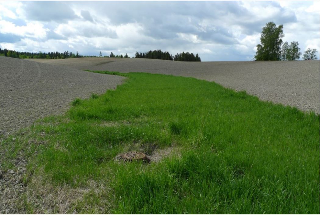
Grassed waterways are shallow channels (natural or constructed) with grass cover, used to drain surface runoff from cropland and prevent erosion.
2.2 การอธิบายแบบละเอียดของเทคโนโลยี
คำอธิบาย:
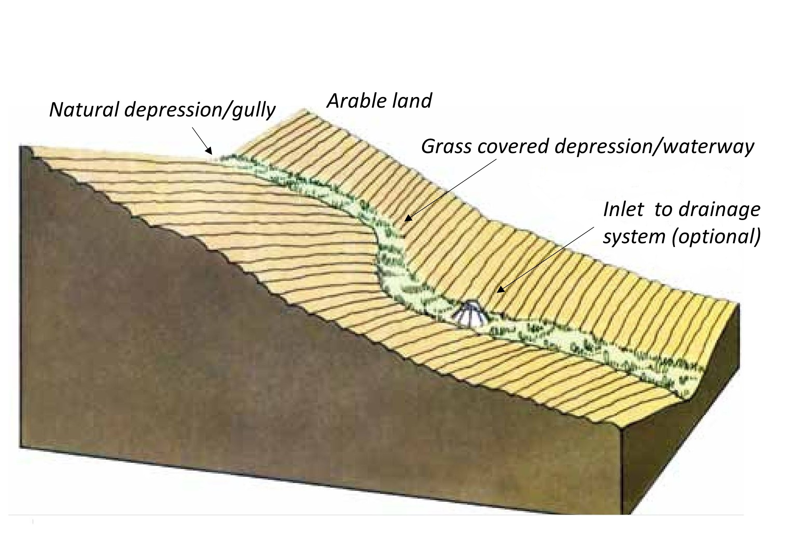
In this documentation we focus on the grassed waterways as a measure to carry surface water down the slope without causing soil erosion. The overland flow can be concentrated in topographic depressions, "thalwegs" in the field. Concentrated runoff in such watercourses can create small rills or even gullies. Vegetation/grass disrupt the water flow, but more importantly to protect the soil from erosive forces.
Purpose/aim: Grassed waterways are important conservation measures managing concentrated flow, especially in agricultural areas: runoff concentrates over grassed areas rather than on bare erodible soil (after tillage). They are intended to reduce runoff velocity and soil erosion by grass roots binding the soil. They also help to enhance infiltration, filtering runoff and contribute to sediment and nutrient deposition.
Establishment/maintenance: Grassed waterways are commonly used in areas where waterways are especially erosion-prone. They are normally sited downslope along natural depressions leading water away from agricultural fields. To control surface runoff, grassed waterways are often combined with inlets for surface water leading runoff to drainage pipes.
According to Regional Environmental Programme (RMP) in Norway, permanent grass cover in topographical depressions should be at least 6 m wide. Grass should be sown in the spring to ensure that it is well established in autumn. The choice of grass species depend on whether there is intention of (for example) using the grass for fodder. The grass can be fertilized or treated by herbicides, since they are located inside the production area. The grass can be harvested to maintain land area for food production and reduce nutrient leakage to the watercourse. Area can be tilled only when renewing the grass cover.
An alternative to grassed waterways is to leave the natural waterways covered in stubble over winter (i.e. unploughed). This measure reduces erosion but will not be as effective as grass cover and will not have the same effect on uptake of nutrients as grass cover waterways, as stubble is dead material.
Efficiency /Impact: The effect of (any) vegetation zones depend on several factors such as the flow properties and the characteristics of the vegetative surface. Significant flow properties are velocity (and hence the slope gradient) and water volume, the particle size and concentration of the sediment in the runoff, and duration and intensity of precipitation. For Norwegian conditions there is also the effect of frozen or unfrozen soil and intensity of snowmelt influence on runoff (surface runoff and infiltration).
Studies of Norwegian conditions indicate that the most relevant factor for function of the vegetation zone is the character of the vegetation (height, robustness, and density), rather than the type of vegetation (Blankenberg & Hougsrud 2010). As the efficiency of vegetation comprises a variety of factors, the implementation of the measures is to a large degree site-specific (Kværnø & Stolte 2012).
The effect of grassed waterways on soil loss has been documented in only a few studies. In Norway, only one study examined the effect of grassed waterways in a small agricultural catchment (26.8 daa or 2.68 ha) in Romerike (Akershus, Viken) and it showed 55% reduction of soil loss (average from 8 years) after implementation of grassed waterways.
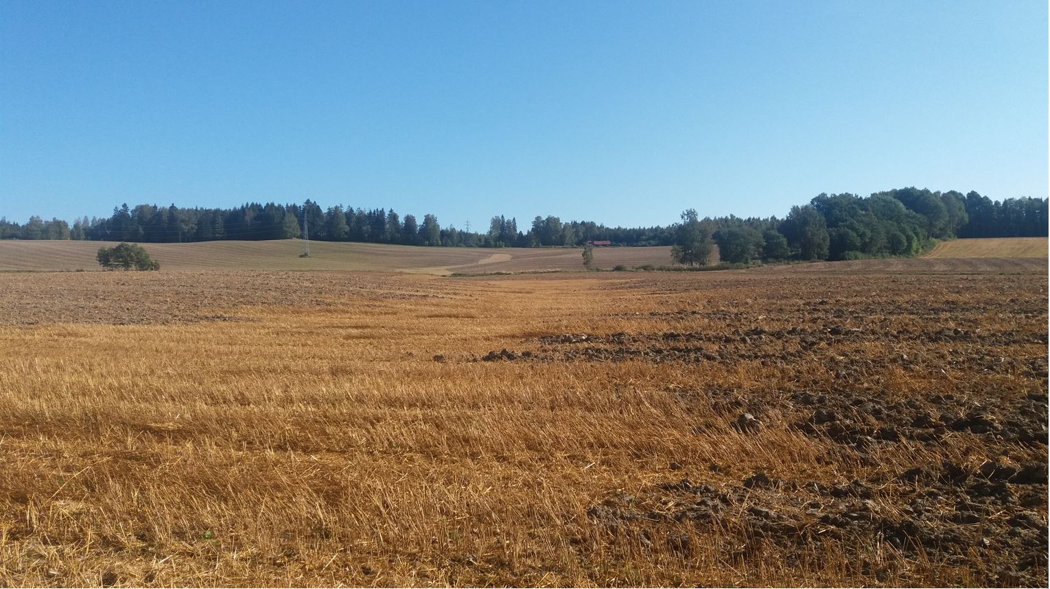
Natural / human environment: The information about the technology is based on investigations and/or reports from different part of Norway.
For the purpose of OPTAIN project (https://www.optain.eu/), the technology is further presented in the natural and human environment context of the Kråkstad River catchment - a Norwegian Case Study catchment within OPTAIN project.
The Kråkstad River is mainly situated in Ski municipality in South-Eastern parts of Norway. The river catchment is a western tributary of the Vansjø-Hobøl watercourse, also known as the Morsa watercourse. The Kråkstad River catchment area is c.a 51 km², 43% of which is agricultural land, where mostly cereals are produced on heavy clays soils. The main environmental challenge in the area is water quality (incl. high phosphorus pollution) and soil erosion (incl. riverbank erosion and quick-clay landslides).The Morsa watercourse is a drinking water resource and there are specific environmental regulations for land management followed by subsidies through the Regional Environmental Programme (RMP).
2.3 รูปภาพของเทคโนโลยี
อัลบั้มสื่อบันทึก

2.5 ประเทศภูมิภาค หรือสถานที่ตั้งที่เทคโนโลยีได้นำไปใช้และได้รับการครอบคลุมโดยการประเมินนี้
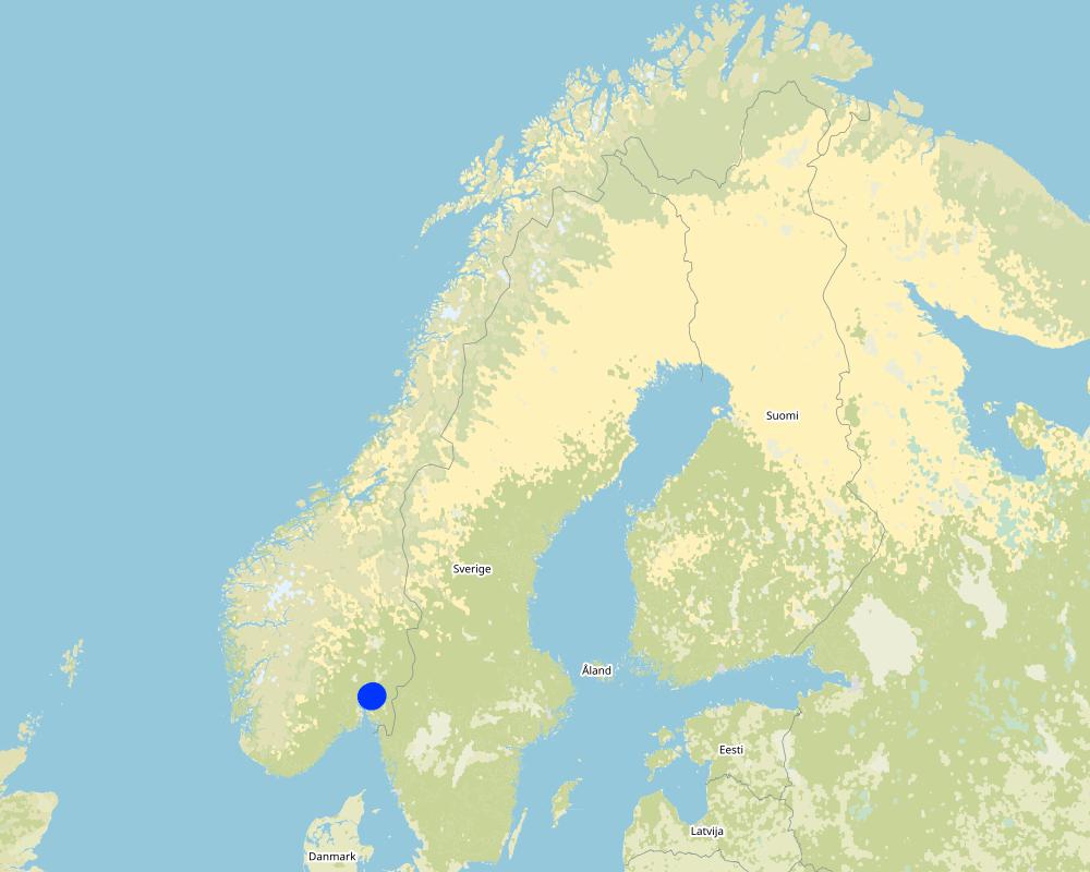
ประเทศ:
นอร์เวย์
ภูมิภาค/รัฐ/จังหวัด:
Viken county
ข้อมูลจำเพาะเพิ่มเติมของสถานที่ตั้ง :
The Vansjø-Hobøl catchment
ระบุการกระจายตัวของเทคโนโลยี:
- กระจายไปอย่างสม่ำเสมอในพื้นที่
If precise area is not known, indicate approximate area covered:
- 0.1-1 ตร.กม.
Is/are the technology site(s) located in a permanently protected area?
ไม่ใช่
Map
×2.6 วันที่การดำเนินการ
ถ้าไม่รู้ปีที่แน่นอน ให้ระบุวันที่โดยประมาณ:
- 10-50 ปี
2.7 คำแนะนำของเทคโนโลยี
ให้ระบุว่าเทคโนโลยีถูกแนะนำเข้ามาอย่างไร:
- ทางโครงการหรือจากภายนอก
- Regional Environmental Programme (RMP)
ความคิดเห็น (ประเภทของโครงการ เป็นต้น) :
Grassed waterways are measures eligible for subsidies in the Regional Environmental Programme (RMP).
3. การจัดประเภทของเทคโนโลยี SLM
3.1 วัตถุประสงค์หลักของเทคโนโลยี
- ลด ป้องกัน ฟื้นฟู การเสื่อมโทรมของที่ดิน
- ป้องกันพื้นที่ลุ่มน้ำ/บริเวณท้ายน้ำ โดยร่วมกับเทคโนโลยีอื่นๆ
- ปรับตัวเข้ากับการเปลี่ยนแปลงภูมิอากาศของโลก สภาพภูมิอากาศที่รุนแรงและผลกระทบ
3.2 ประเภทของการใช้ที่ดินในปัจจุบันที่ได้นำเทคโนโลยีไปใช้
Land use mixed within the same land unit:
ไม่ใช่

พื้นที่ปลูกพืช
- การปลูกพืชล้มลุกอายุปีเดียว
Annual cropping - Specify crops:
- cereals - other
- small grains
จำนวนของฤดูเพาะปลูกต่อปี:
- 1

ป่า/พื้นที่ทำไม้
- natural forest

ทางน้ำ แหล่งน้ำ พื้นที่ชุ่มน้ำ
- ทางระบายน้ำ ทางน้ำ
3.3 Has land use changed due to the implementation of the Technology?
Has land use changed due to the implementation of the Technology?
- No (Continue with question 3.4)
3.4 การใช้น้ำ
การใช้น้ำของที่ดินที่มีการใช้เทคโนโลยีอยู่:
- จากน้ำฝน
3.5 กลุ่ม SLM ที่ตรงกับเทคโนโลยีนี้
- การปรับปรุงดิน / พืชคลุมดิน
- มาตรการปลูกพืชขวางความลาดชัน (cross-slope measure)
- การผันน้ำและการระบายน้ำ
3.6 มาตรการ SLM ที่ประกอบกันเป็นเทคโนโลยี

มาตรการอนุรักษ์ด้วยวิธีพืช
- V2: หญ้าและไม้ยืนต้น
3.7 รูปแบบหลักของการเสื่อมโทรมของที่ดินที่ได้รับการแก้ไขโดยเทคโนโลยี

การกัดกร่อนของดินโดยน้ำ
- Wt (Loss of topsoil): การสูญเสียดินชั้นบนหรือการกัดกร่อนที่ผิวดิน
- Wg (Gully erosion): การกัดกร่อนแบบร่องธารหรือการทำให้เกิดร่องน้ำเซาะ

การเสื่อมโทรมของน้ำ
- Hp (Decline of surface water quality): การลดลงของคุณภาพน้ำที่ผิวดิน
3.8 การป้องกัน การลดลง หรือการฟื้นฟูความเสื่อมโทรมของที่ดิน
ระบุเป้าหมายของเทคโนโลยีกับความเสื่อมโทรมของที่ดิน:
- ป้องกันความเสื่อมโทรมของที่ดิน
- ลดความเสื่อมโทรมของดิน
4. ข้อมูลจำเพาะด้านเทคนิค กิจกรรมการนำไปปฏิบัติใช้ ปัจจัยนำเข้า และค่าใช้จ่าย
4.1 แบบแปลนทางเทคนิคของเทคโนโลยี
ข้อมูลจำเพาะด้านเทคนิค (แบบแปลนทางเทคนิคของเทคโนโลยี):
Grassed waterways in topographic depressions in the field
ผู้เขียน:
Lillian Øygarden
4.2 ข้อมูลทั่วไปเกี่ยวกับการคำนวณปัจจัยนำเข้าและค่าใช้จ่าย
ให้ระบุว่าค่าใช้จ่ายและปัจจัยนำเข้าได้รับการคำนวณอย่างไร:
- ต่อหน่วยเทคโนโลยี
โปรดระบุหน่วย:
length of grassed waterways
Specify dimensions of unit (if relevant):
meters
อื่นๆ หรือสกุลเงินประจำชาติ (ระบุ):
NOK
If relevant, indicate exchange rate from USD to local currency (e.g. 1 USD = 79.9 Brazilian Real): 1 USD =:
8.99
ระบุค่าเฉลี่ยของค่าจ้างในการจ้างแรงงานต่อวัน:
c.a. 3000 NOK (it is only the cost of the time assuming 8h work per day, 320-500 NOK/hour/ person. Machinery, equipment, materials not included)
4.3 กิจกรรมเพื่อการจัดตั้ง
| กิจกรรม | Timing (season) | |
|---|---|---|
| 1. | Plowing | before sowing |
| 2. | Harrowing | before sowing |
| 3. | Sowing grass | in spring |
4.4 ค่าใช้จ่ายของปัจจัยนำเข้าที่จำเป็นสำหรับการจัดตั้ง
ถ้าผู้ใช้ที่ดินรับภาระน้อยกว่า 100% ของค่าใช้จ่าย ให้ระบุว่าใครเป็นผู้รับผิดชอบส่วนที่เหลือ:
Grassed waterways are eligible for subsidies in Regional Environmental Programme (RMP)
แสดงความคิดเห็น:
The costs of establishment and management of grassed waterways are connected to sowing the area and reduced area for cereal production (in case of cereal production farm). The subsidies should be a compensation for such costs. Costs are extremely varied so no estimate is relevant here.
Within RMP for 2019-2022 the subsidy level for maintaining grassed waterways was at the level of 30 kr/m in Viken region.
4.5 การบำรุงรักษาสภาพหรือกิจกรรมที่เกิดขึ้นเป็นประจำ
| กิจกรรม | ช่วงระยะเวลา/ความถี่ | |
|---|---|---|
| 1. | Harvesting grass | 2-3 times/yr |
| 2. | Plowing | In case the re-establishment is needed |
| 3. | Harrowing | In case the re-establishment is needed |
| 4. | Sowing grass | In case the re-establishment is needed |
แสดงความคิดเห็น:
Grassed waterways are supposed to exist for several years. The grass can be harvested each year (1- 3 times /year) but plowing, harvesting and sowing is only done when the waterway is established or re established.
4.6 ค่าใช้จ่ายของปัจจัยนำเข้าและกิจกรรมที่เกิดขึ้นเป็นประจำที่ต้องการการบำรุงรักษา (ต่อปี)
ถ้าผู้ใช้ที่ดินรับภาระน้อยกว่า 100% ของค่าใช้จ่าย ให้ระบุว่าใครเป็นผู้รับผิดชอบส่วนที่เหลือ:
Grassed waterways is a measure eligible for subsidies in Regional Environmental Programme (RMP).
แสดงความคิดเห็น:
The costs of establishment and management of grassed waterways are connected to sowing the area and reduced area for cereal production (in case of cereal production farm). There is no general rule for harvesting. However, if farmers harvest the grass they can get the income. If the grass is not harvested then the production area is reduced. The subsidies should be a compensation for such costs.
Within RMP for 2019-2022 the subside level for maintaining grassed waterways was at the level of 30 kr/m in Viken region.
4.7 ปัจจัยสำคัญที่สุดที่มีผลกระทบต่อค่าใช้จ่าย
ปัจจัยสำคัญที่สุดที่มีผลกระทบต่อค่าใช้จ่ายต่างๆ:
The costs of establishment and management of grassed waterways are connected to sowing the area and reduced area for cereal production (in case of cereal production farm). There is no general rule for harvesting. However, if farmers harvest the grass they can get the income. If the grass is not harvested then the production area is reduced. The subsidies should be a compensation for such costs.
The cost of the area management is dependent on:
- Location (priority areas)
- Type of grass
- Possibility to use the grass as a fodder
Grassed waterways are eligible for subsidies in Regional Environmental Programme (RMP).
Within RMP for 2019-2022 the subside level for maintaining grassed waterways was at the level of 30 kr/m in Viken region.
5. สิ่งแวดล้อมทางธรรมชาติและของมนุษย์
5.1 ภูมิอากาศ
ฝนประจำปี
- < 250 ม.ม.
- 251-500 ม.ม.
- 501-750 ม.ม.
- 751-1,000 ม.ม.
- 1,001-1,500 ม.ม.
- 1,501-2,000 ม.ม.
- 2,001-3,000 ม.ม.
- 3,001-4,000 ม.ม.
- > 4,000 ม.ม.
เขตภูมิอากาศเกษตร
- กึ่งชุ่มชื้น
- กึ่งแห้งแล้ง
Thermal climate class: temperate
Thermal climate class: boreal
5.2 สภาพภูมิประเทศ
ค่าเฉลี่ยความลาดชัน:
- ราบเรียบ (0-2%)
- ลาดที่ไม่ชัน (3-5%)
- ปานกลาง (6-10%)
- เป็นลูกคลื่น (11-15%)
- เป็นเนิน (16-30%)
- ชัน (31-60%)
- ชันมาก (>60%)
ธรณีสัณฐาน:
- ที่ราบสูง/ที่ราบ
- สันเขา
- ไหล่เขา
- ไหล่เนินเขา
- ตีนเนิน
- หุบเขา
ระดับความสูง:
- 0-100 เมตร
- 101-500 เมตร
- 501-1,000 เมตร
- 1,001-1,500 เมตร
- 1,501-2,000 เมตร
- 2,001-2,500 เมตร
- 2,501-3,000 เมตร
- 3,001-4,000 เมตร
- > 4,000 เมตร
5.3 ดิน
ค่าเฉลี่ยความลึกของดิน:
- ตื้นมาก (0-20 ซ.ม.)
- ตื้น (21-50 ซ.ม.)
- ลึกปานกลาง (51-80 ซ.ม.)
- ลึก (81-120 ซ.ม.)
- ลึกมาก (>120 ซ.ม.)
เนื้อดิน (ดินชั้นบน):
- ปานกลาง (ดินร่วน ทรายแป้ง)
- ละเอียด/หนัก (ดินเหนียว)
เนื้อดินล่าง (> 20 ซ.ม.ต่ำจากผิวดิน):
- ปานกลาง (ดินร่วน ทรายแป้ง)
- ละเอียด/หนัก (ดินเหนียว)
อินทรียวัตถุในดิน:
- ปานกลาง (1-3%)
(ถ้ามี) ให้แนบคำอธิบายเรื่องดินแบบเต็มหรือระบุข้อมูลที่มีอยู่ เช่น ชนิดของดิน ค่า pH ของดินหรือความเป็นกรดของดิน ความสามารถในการแลกเปลี่ยนประจุบวก ไนโตรเจน ความเค็ม เป็นต้น:
Soil fertility is medium-high
Soil drainage/infiltration is poor, artificial drainage is needed
Soil water storage capacity is very low-low
5.4 ความเป็นประโยชน์และคุณภาพของน้ำ
ระดับน้ำใต้ดิน:
<5 เมตร
น้ำไหลบ่าที่ผิวดิน:
ดี
คุณภาพน้ำ (ที่ยังไม่ได้บำบัด):
เป็นน้ำใช้เพื่อการเกษตรเท่านั้น (การชลประทาน)
Water quality refers to:
both ground and surface water
ความเค็มของน้ำเป็นปัญหาหรือไม่:
ไม่ใช่
กำลังเกิดน้ำท่วมในพื้นที่หรือไม่:
ใช่
5.5 ความหลากหลายทางชีวภาพ
ความหลากหลายทางชนิดพันธุ์:
- ต่ำ
ความหลากหลายของแหล่งที่อยู่:
- ต่ำ
5.6 ลักษณะของผู้ใช้ที่ดินที่นำเทคโนโลยีไปปฏิบัติใช้
อยู่กับที่หรือเร่ร่อน:
- อยู่กับที่
แนวทางการตลาดของระบบการผลิต:
- mixed (subsistence/ commercial)
- ทำการค้า/การตลาด
รายได้ที่มาจากนอกฟาร์ม:
- 10-50% ของรายได้ทั้งหมด
- > 50% ของรายได้ทั้งหมด
ระดับของความมั่งคั่งโดยเปรียบเทียบ:
- พอมีพอกิน
- รวย
เป็นรายบุคคล/ครัวเรือน:
- เป็นรายบุคคล/ครัวเรือน
ระดับของการใช้เครื่องจักรกล:
- การใช้เครื่องจักรหรือเครื่องยนต์
เพศ:
- หญิง
- ชาย
อายุของผู้ใช้ที่ดิน:
- ผู้เยาว์
- วัยกลางคน
ระบุลักษณะอื่นๆที่เกี่ยวข้องของผู้ใช้ที่ดิน:
Land users applying the Technology are mainly common / average land users
Population density: < 10 persons/km2
Annual population growth: < 0.5%
10% of the land users are rich and own 10% of the land.
90% of the land users are average wealthy and own 90% of the land.
5.7 Average area of land used by land users applying the Technology
- < 0.5 เฮกตาร์
- 0.5-1 เฮกตาร์
- 1-2 เฮกตาร์
- 2-5 เฮกตาร์
- 5-15 เฮกตาร์
- 15-50 เฮกตาร์
- 50-100 เฮกตาร์
- 100-500 เฮกตาร์
- 500-1,000 เฮกตาร์
- 1,000-10,000 เฮกตาร์
- >10,000 เฮกตาร์
พิจารณาว่าเป็นขนาดเล็ก กลาง หรือขนาดใหญ่ (ซึ่งอ้างอิงถึงบริบทระดับท้องถิ่น):
- ขนาดกลาง
5.8 กรรมสิทธิ์ในที่ดิน สิทธิในการใช้ที่ดินและสิทธิในการใช้น้ำ
กรรมสิทธิ์ในที่ดิน:
- รายบุคคล ได้รับสิทธิครอบครอง
สิทธิในการใช้ที่ดิน:
- เกี่ยวกับชุมชน (ถูกจัดระเบียบ)
- รายบุคคล
สิทธิในการใช้น้ำ:
- เข้าถึงได้แบบเปิด (ไม่ได้จัดระเบียบ)
5.9 การเข้าถึงบริการและโครงสร้างพื้นฐาน
สุขภาพ:
- จน
- ปานกลาง
- ดี
การศึกษา:
- จน
- ปานกลาง
- ดี
ความช่วยเหลือทางด้านเทคนิค:
- จน
- ปานกลาง
- ดี
การจ้างงาน (เช่น ภายนอกฟาร์ม):
- จน
- ปานกลาง
- ดี
ตลาด:
- จน
- ปานกลาง
- ดี
พลังงาน:
- จน
- ปานกลาง
- ดี
ถนนและการขนส่ง:
- จน
- ปานกลาง
- ดี
น้ำดื่มและการสุขาภิบาล:
- จน
- ปานกลาง
- ดี
บริการด้านการเงิน:
- จน
- ปานกลาง
- ดี
6. ผลกระทบและสรุปคำบอกกล่าว
6.1 ผลกระทบในพื้นที่ดำเนินการ (On-site) จากการใช้เทคโนโลยี
ผลกระทบทางด้านเศรษฐกิจและสังคม
การผลิต
การผลิตพืชผล
แสดงความคิดเห็น/ระบุ:
Land removed from crop production. If harvested as fodder - then contribute positive to income.
รายได้และค่าใช้จ่าย
รายได้จากฟาร์ม
ผลกระทบด้านนิเวศวิทยา
วัฐจักรน้ำหรือน้ำบ่า
ปริมาณน้ำ
แสดงความคิดเห็น/ระบุ:
Enhanced infiltration
คุณภาพน้ำ
แสดงความคิดเห็น/ระบุ:
Ideally less sediment (and phosphorus) is transported to the surface waters (rivers, lakes), and consequently water quality is increased.
น้ำไหลบ่าที่ผิวดิน
แสดงความคิดเห็น/ระบุ:
Due to enhanced infiltration in the grassed areas and reduction of surface runoff velocity
การระบายน้ำส่วนเกิน
แสดงความคิดเห็น/ระบุ:
When combined with inlet to the drainage system
ดิน
สิ่งปกคลุมดิน
การสูญเสียดิน
ความหลากหลายทางชีวภาพของพืชและสัตว์
การปกคลุมด้วยพืช
ลดความเสี่ยงของภัยพิบัติ
ดินถล่ม/ ซากต่าง ๆ ที่ถูกพัดพามา
6.2 ผลกระทบนอกพื้นที่ดำเนินการ (Off-site) จากการใช้เทคโนโลยี
การเกิดมลพิษในน้ำบาดาลหรือแม่น้ำ
ความสามารถต้านทานการเปลี่ยนแปลง / ความสามารถในการคัดกรอง
6.3 การเผชิญและความตอบสนองของเทคโนโลยีต่อการเปลี่ยนแปลงสภาพภูมิอากาศที่ค่อยเป็นค่อยไป และสภาพรุนแรงของภูมิอากาศ / ภัยพิบัติ (ที่รับรู้ได้โดยผู้ใช้ที่ดิน)
การเปลี่ยนแปลงสภาพภูมิอากาศที่ค่อยเป็นค่อยไป
การเปลี่ยนแปลงสภาพภูมิอากาศที่ค่อยเป็นค่อยไป
| ฤดู | increase or decrease | เทคโนโลยีมีวิธีการรับมืออย่างไร | |
|---|---|---|---|
| อุณหภูมิประจำปี | เพิ่มขึ้น | ดี | |
| ฝนประจำปี | เพิ่มขึ้น | ดี |
สภาพรุนแรงของภูมิอากาศ (ภัยพิบัติ)
ภัยพิบัติทางอุตุนิยมวิทยา
| เทคโนโลยีมีวิธีการรับมืออย่างไร | |
|---|---|
| พายุฝนประจำท้องถิ่น | ดี |
ภัยพิบัติจากน้ำ
| เทคโนโลยีมีวิธีการรับมืออย่างไร | |
|---|---|
| น้ำท่วมตามปกติ (แม่น้ำ) | ดี |
6.4 การวิเคราะห์ค่าใช้จ่ายและผลประโยชน์ที่ได้รับ
ผลประโยชน์ที่ได้รับเปรียบเทียบกับค่าใช้จ่ายในการจัดตั้งเป็นอย่างไร (จากมุมมองของผู้ใช้ที่ดิน)
ผลตอบแทนระยะสั้น:
เป็นกลางหรือสมดุล
ผลตอบแทนระยะยาว:
เป็นกลางหรือสมดุล
ผลประโยชน์ที่ได้รับเปรียบเทียบกับค่าใช้จ่ายในการบำรุงรักษาหรือต้นทุนที่เกิดขึ้นซ้ำอีก เป็นอย่างไร (จากมุมมองของผู้ใช้ที่ดิน)
ผลตอบแทนระยะสั้น:
เป็นกลางหรือสมดุล
ผลตอบแทนระยะยาว:
เป็นกลางหรือสมดุล
6.5 การปรับตัวของเทคโนโลยี
- 11-50%
Of all those who have adopted the Technology, how many did so spontaneously, i.e. without receiving any material incentives/ payments?
- 0-10%
แสดงความคิดเห็น:
There is no trend towards spontaneous adoption of the Technology.
6.6 การปรับตัว
เทคโนโลยีได้รับการปรับเปลี่ยนเมื่อเร็วๆนี้ เพื่อให้ปรับตัวเข้ากับสภาพที่กำลังเปลี่ยนแปลงหรือไม่:
ไม่ใช่
6.7 จุดแข็ง / ข้อได้เปรียบ / โอกาสของเทคโนโลยี
| จุดแข็ง / ข้อได้เปรียบ / โอกาสในทัศนคติของผู้ใช้ที่ดิน |
|---|
| Less soil loss |
| จุดแข็ง / ข้อได้เปรียบ / โอกาสในทัศนคติของผู้รวบรวมหรือวิทยากรหลัก |
|---|
| Reduced erosion |
| Improved water quality |
6.8 จุดอ่อน / ข้อเสียเปรียบ / ความเสี่ยงของเทคโนโลยีและวิธีการแก้ไข
| จุดอ่อน / ข้อเสียเปรียบ / ความเสี่ยงในทัศนคติของผู้ใช้ที่ดิน | มีวิธีการแก้ไขได้อย่างไร |
|---|---|
| Land must be removed from crop production. | |
| Some maintenance is needed periodically so that erosion does not occur along the edges. |
| จุดอ่อน / ข้อเสียเปรียบ / ความเสี่ยงในทัศนคติของผู้รวบรวมหรือวิทยากรหลัก | มีวิธีการแก้ไขได้อย่างไร |
|---|---|
| No enough research about efficiency of Technology | More research |
7. การอ้างอิงและการเชื่อมต่อ
7.1 วิธีการและแหล่งข้อมูล
- การเก็บรวบรวมมาจากรายงานและเอกสารที่มีอยู่
see references
วันที่เก็บรวบรวมข้อมูล(ภาคสนาม) :
11/02/2022
7.2 การอ้างอิงถึงสิ่งตีพิมพ์
หัวข้อ, ผู้เขียน, ปี, หมายเลข ISBN:
Kværnø S., Øygarden L., Bechmann M., Barneveld R. 2020. Tiltak mot erosjon på jordbruksareal. NIBIO POP 6(38)2020
ชื่อเรื่อง ผู้เขียน ปี ISBN:
NIBIO website
หัวข้อ, ผู้เขียน, ปี, หมายเลข ISBN:
Blankenberg, A-G.B. and Skarbøvik E. 2019. Vegetasjon som miljøtiltak i jordbruket: Varianter, tilskudd og lovverk.NIBIO POP 5(10) 2019
ชื่อเรื่อง ผู้เขียน ปี ISBN:
NIBIO website
หัวข้อ, ผู้เขียน, ปี, หมายเลข ISBN:
Øygarden L. 2003. Rill and gully development during an extreme winter runoff event in Norway. CATENA 50
ชื่อเรื่อง ผู้เขียน ปี ISBN:
CATENA
7.3 Links to relevant online information
ชื่อเรื่องหรือคำอธิบาย:
Kværnø S., Øygarden L., Bechmann M., Barneveld R. 2020. Tiltak mot erosjon på jordbruksareal. NIBIO POP 6(38)2020
URL:
https://nibio.brage.unit.no/nibio-xmlui/bitstream/handle/11250/2723843/NIBIO_POP_2020_6_38.pdf?sequence=4&isAllowed=y
ชื่อเรื่องหรือคำอธิบาย:
Blankenberg, A-G.B. and Skarbøvik E. 2019. Vegetasjon som miljøtiltak i jordbruket: Varianter, tilskudd og lovverk.NIBIO POP 5(10) 2019
URL:
https://nibio.brage.unit.no/nibio-xmlui/bitstream/handle/11250/2590439/NIBIO_POP_2019_5_10.pdf?sequence=1&isAllowed=y
7.4 General comments
no remarks
ลิงก์และโมดูล
ขยายทั้งหมด ย่อทั้งหมดลิงก์
Regional Environmental program [นอร์เวย์]
Regulations and financial grants for reduction of pollution and promotion of the cultural landscape.
- ผู้รวบรวม: Kamilla Skaalsveen
โมดูล
ไม่มีโมดูล