From storylines to scenarios: raising awareness and decision support [ບາຊິວ]
- ການສ້າງ:
- ປັບປູງ:
- ຜູ້ສັງລວມຂໍ້ມູນ: Jan Goepel
- ບັນນາທິການ: –
- ຜູ້ທົບທວນຄືນ: David Streiff, Deborah Niggli
approaches_2616 - ບາຊິວ
ເບິ່ງພາກສ່ວນ
ຂະຫຍາຍທັງໝົດ ຍຸບທັງໝົດ1. ຂໍ້ມູນທົ່ວໄປ
1.2 ລາຍລະອຽດ ການຕິດຕໍ່ ຂອງບຸກຄົນທີ່ຊັບພະຍາກອນ ແລະ ສະຖາບັນ ການມີສ່ວນຮ່ວມ ໃນການປະເມີນຜົນ ແລະ ເອກະສານ ຂອງວິທີທາງ
ຜູ້ຊ່ຽວຊານ ດ້ານການຄຸ້ມຄອງ ທີ່ດິນແບບຍືນຍົງ:
ຜູ້ຊ່ຽວຊານ ດ້ານການຄຸ້ມຄອງ ທີ່ດິນແບບຍືນຍົງ:
Gil Juliana
julianagil@uol.com.br
Embrapa Rice & Beans,
ບາຊິວ
Guggenberger Georg
Leibniz University Hannover
ເຢຍລະມັນ
ຜູ້ຊ່ຽວຊານ ດ້ານການຄຸ້ມຄອງ ທີ່ດິນແບບຍືນຍົງ:
Klingler Michael
University of Innsbruck
ເຢຍລະມັນ
ຜູ້ຊ່ຽວຊານ ດ້ານການຄຸ້ມຄອງ ທີ່ດິນແບບຍືນຍົງ:
Lakes Tobia
Humboldt-University Berlin
ຜູ້ຊ່ຽວຊານ ດ້ານການຄຸ້ມຄອງ ທີ່ດິນແບບຍືນຍົງ:
Böhner Jürgen
University Hamburg
ເຢຍລະມັນ
ຜູ້ຊ່ຽວຊານ ດ້ານການຄຸ້ມຄອງ ທີ່ດິນແບບຍືນຍົງ:
Schaldach Rüdiger
University Kassel
ເຢຍລະມັນ
ຜູ້ຊ່ຽວຊານ ດ້ານການຄຸ້ມຄອງ ທີ່ດິນແບບຍືນຍົງ:
Siebold Matthias
University Hohenheim
ເຢຍລະມັນ
ຜູ້ຊ່ຽວຊານ ດ້ານການຄຸ້ມຄອງ ທີ່ດິນແບບຍືນຍົງ:
Nendel Claas
Leibniz Centre for Agricultural Landscape Research (ZALF)
ເຢຍລະມັນ
ຜູ້ຊ່ຽວຊານ ດ້ານການຄຸ້ມຄອງ ທີ່ດິນແບບຍືນຍົງ:
Schönenberg Regine
Free University Berlin
ເຢຍລະມັນ
ຜູ້ຊ່ຽວຊານ ດ້ານການຄຸ້ມຄອງ ທີ່ດິນແບບຍືນຍົງ:
Gerold Gerhard
Georg August University Göttingen
ເຢຍລະມັນ
ຊື່ຂອງໂຄງການ ທີ່ອໍານວຍຄວາມສະດວກ ໃນການສ້າງເອກກະສານ ຫຼື ປະເມີນດ້ານແນວທາງ (ຖ້າກ່ຽວຂ້ອງ)
Carbon optimized land management strategies for southern Amazonia (CARBIOCIAL / GLUES)ຊື່ຂອງໂຄງການ ທີ່ອໍານວຍຄວາມສະດວກ ໃນການສ້າງເອກກະສານ ຫຼື ປະເມີນດ້ານແນວທາງ (ຖ້າກ່ຽວຂ້ອງ)
Book project: Making sense of research for sustainable land management (GLUES)ຊື່ຂອງ ສະຖາບັນການຈັດຕັ້ງ ທີ່ອໍານວຍຄວາມສະດວກ ໃນການສ້າງເອກກະສານ ຫຼື ປະເມີນແນວທາງ (ຖ້າກ່ຽວຂ້ອງ)
Georg August Universität Göttingen (Georg August Universität Göttingen) - ເຢຍລະມັນຊື່ຂອງ ສະຖາບັນການຈັດຕັ້ງ ທີ່ອໍານວຍຄວາມສະດວກ ໃນການສ້າງເອກກະສານ ຫຼື ປະເມີນແນວທາງ (ຖ້າກ່ຽວຂ້ອງ)
Leibniz Institute for Regional Geography (IfL) - ເຢຍລະມັນຊື່ຂອງ ສະຖາບັນການຈັດຕັ້ງ ທີ່ອໍານວຍຄວາມສະດວກ ໃນການສ້າງເອກກະສານ ຫຼື ປະເມີນແນວທາງ (ຖ້າກ່ຽວຂ້ອງ)
Humboldt Universität zu Berlin (HU Berlin) - ເຢຍລະມັນຊື່ຂອງ ສະຖາບັນການຈັດຕັ້ງ ທີ່ອໍານວຍຄວາມສະດວກ ໃນການສ້າງເອກກະສານ ຫຼື ປະເມີນແນວທາງ (ຖ້າກ່ຽວຂ້ອງ)
Universität Kassel - ເຢຍລະມັນຊື່ຂອງ ສະຖາບັນການຈັດຕັ້ງ ທີ່ອໍານວຍຄວາມສະດວກ ໃນການສ້າງເອກກະສານ ຫຼື ປະເມີນແນວທາງ (ຖ້າກ່ຽວຂ້ອງ)
Universität Hamburg (UHH) - ເຢຍລະມັນ1.3 ເງື່ອນໄຂ ຂອງການນໍາໃຊ້ເອກກະສານຂໍ້ມູນ ຂອງ WOCAT
ເມື່ອໃດທີ່ໄດ້ສັງລວມຂໍ້ມູນ (ຢູ່ພາກສະໜາມ)?
18/06/2016
ຜູ້ສັງລວມ ແລະ ບັນດາຜູ້ຕອບແບບສອບຖາມ ຍອມຮັບໃນເງື່ອນໄຂ ການນໍາໃຊ້ຂໍ້ມູນເອກະສານ ທີ່ສ້າງຂື້ນ ໂດຍຜ່ານ ອົງການ WOCAT:
ແມ່ນ
1.4 ເອກະສານອ້າງອີງ (ຫຼາຍ) ກັບແບບສອບຖາມ (ຫຼາຍ) ເຕັກໂນໂລຢີ ຂອງດ້ານການຄຸ້ມຄອງ ດິນແບບຍືນຍົງ
Carbon-enrichment of tropical agricultural soil with organic matter [ບາຊິວ]
Carbon-enrichment of tropical agricultural soils with locally available organic matter in the Cerrado agricultural landscape, Brazil.
- ຜູ້ສັງລວມຂໍ້ມູນ: Luisa F. Vega
2. ພັນລະນາ ແນວທາງການຄຸ້ມຄອງນໍາໃຊ້ດິນແບບຍືນຍົງ
2.1 ການອະທິບາຍ ໂດຍຫຍໍ້ ຂອງວິທີທາງ
Investigating viable carbon-optimized land management strategies, which maintain or improve ecosystem function, under changing climate conditions in the Southern Amazon - using regional scenarios generated from storylines.
2.2 ການອະທິບາຍ ລາຍລະອຽດ ຂອງວິທີທາງ
ການອະທິບາຍ ລາຍລະອຽດ ຂອງວິທີທາງ:
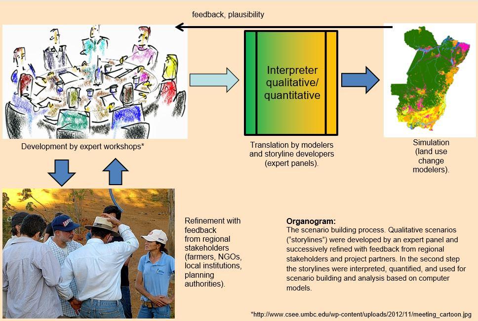
Aims / objectives: One objective of the Carbiocial project, in close cooperation with its Brazilian partner project Carbioma, is to explore how land use change in one of Brazil’s most dynamic regions will develop in the next 30 years and how it will be affected by the implementation of land-use planning options and conservation policies. For this purpose a set of scenarios was created. The scenarios portray different plausible development pathways for the region. Each scenario consists of a storyline: a brief narrative of the future. At this level farmers and institutions are involved. An expert panel translated the findings of several stakeholder workshops and extensive stakeholder and expert interviews, conducted in 2012, into qualitative information needed to elaborate these scenarios. Four storylines emerged: (1) “business-as-usual”; (2) sustainable, extensive use of the Amazon; (3) legal intensification; (3) illegal intensification.
Methods: It was agreed that the communication between qualitative social science data and quantitative data had to be considered carefully. A blend of the required input factors for the models was agreed as guiding principles for all storylines: these were: population, agrarian production, livestock, agrarian and environmental policies, protected areas, infrastructure, impact of climate change (mitigation/adaptation). In a second step, qualitative data had to be added to the models; to limit bias, all available German experts on Southern Amazonia participated in a day-long (and quite controversial) brainstorming session producing content for the four storylines.
After translating the results into Portuguese the outcome was discussed with representatives of government and NGOs to discuss their plausibility and to modify accordingly. The input of local stakeholders was included on the basis of discussions and qualitative interviews. Generally speaking, the feedback loops with Brazilian stakeholders’ happened rather arbitrarily. Participation could have been better if planned more methodically and earlier.
The three hypothetical storylines describe different pathways of future regional development within the two states. Due to the strong linkages of Southern Amazonia to global markets (e.g. exports of soybean and meat) it was necessary to portray this dependency as one important determinant within the scenarios. Also, law enforcement of the existing legal situation was considered: more than 40% of Amazônia comprises protected areas. In order to portray the possibility of progressive environmental and indigenous legislation, a vibrant civil society, and well-institutionalized public prosecutors, a sustainability scenario was designed.
The next step was the quantification of the qualitative information to facilitate a simulation-based scenario analysis. Simulation models will be combined as software packages to support the decision-taking process from local to landscape and regional scale. All research and implementation activities include direct involvement of the stakeholders. Field experiments for improving C storage and ecosystem function will be performed in cooperation with an NGO founded by the farmers of Mato Grosso.
Other important information: A set of land use maps was generated to depict scenarios from 2010 to 2030. The objective of this modelling and mapping exercise is to support decision-makers to better interpret the scenarios and their implications. These new layers of information will facilitate further model or GIS-based analysis of land use change impacts on the regional carbon balance and the loss of biodiversity, and may act as a test-bed for the development of strategies towards sustainable land management.
2.3 ຮູບພາບຂອງແນວທາງ
ສື່ຮູບພາບ

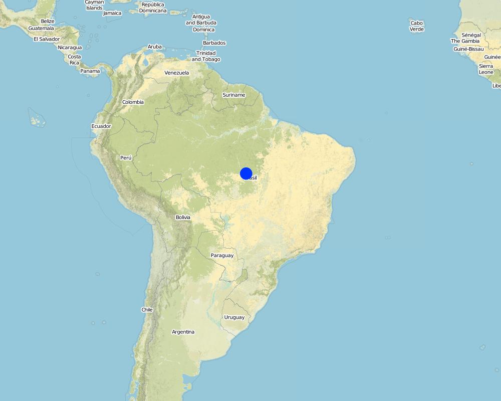
2.5 ປະເທດ / ເຂດ / ສະຖານທີ່ບ່ອນທີ່ແນວທາງໄດ້ຖືກນໍາໃຊ້
ປະເທດ:
ບາຊິວ
ພາກພື້ນ / ລັດ / ແຂວງ:
Mato Grosso/Pará, Brazil
Map
×2.6 ວັນທີເລີ່ມຕົ້ນ ແລະ ສິ້ນສຸດ ການຈັດຕັ້ງປະຕີບັດ ວິທີທາງ
ສະແດງປີຂອງການເລີ່ມຕົ້ນ:
2011
ປີທີ່ສີ້ນສູດ (ຖ້າຢຸດບໍ່ໄດ້ນໍາໃຊ້ ວິທີທາງ):
2016
2.7 ປະເພດຂອງແນວທາງ
- ພາຍໃຕ້ໂຄງການ / ແຜນງານ
2.8 ເປົ້າໝາຍ / ຈຸດປະສົງຫຼັກ ຂອງການຈັດຕັ້ງປະຕິບັດ ວິທີທາງ
The Approach focused mainly on other activities than SLM (carbon-optimized land management)
The joint main goals are 1) to perform region-specific analyses in order to improve and apply interdisciplinary sets of models of land use impacts on carbon stocks, water and GHG balances, 2) to develop and optimize land management strategies that minimize carbon losses and GHG emissions, and maximize carbon sequestration, 3) to assess the trade-offs between land management options and socio-economic impacts in terms of GHG reduction, profitability, ecological sustainability, and last but not least, 4) to support the Brazilian partners to implement the optimal techniques in practice, considering the soybean value chain and overall carbon balance.
The SLM Approach addressed the following problems: High loss of vegetative and soil carbon due to agricultural expansion (deforestation), agricultural emissions, biodiversity loss.
2.9 ເງື່ອນໄຂອໍານວຍ ຫຼື ຂັດຂວາງການປະຕິບັດຂອງເຕັກໂນໂລຢີ / ເຕັກໂນໂລຢີການນໍາໃຊ້ຕາມແນວທາງ
ສັງຄົມ / ວັດທະນະທໍາ / ມາດຕະຖານ ແລະ ຄຸນຄ່າທາງສາສະໜາ
- ເຊື່ອງຊ້ອນ
Acceptance of research results
Treatment through the SLM Approach: Dissemination of research results in the form of policy briefs (short graphical illustration of results) and “output-stick” (USB stick with more detailed research results).
ກ່ຽວກັບກົດໝາຍ (ສິດນໍາໃຊ້ດິນ, ສິດນໍາໃຊ້ນໍ້າ)
- ເຊື່ອງຊ້ອນ
Land tenure
Treatment through the SLM Approach: None
The existing land ownership, land use rights / water rights greatly hindered the approach implementation Especially in Pará, land tenure rights are uncertain and lead to land speculation with resultant land degradation and deforestation.
3. ການມີສ່ວນຮ່ວມ ແລະ ບົດບາດຂອງພາກສ່ວນທີ່ກ່ຽວຂ້ອງທີ່ໄດ້ມີສ່ວນຮ່ວມ
3.1 ຜູ້ມີສ່ວນຮ່ວມ ໃນວິທີທາງ ແລະ ພາລະບົດບາດ ຂອງເຂົາເຈົ້າ
- ຜູ້ນໍາໃຊ້ດິນໃນທ້ອງຖິ່ນ / ຊຸມຊົນທ້ອງຖິ່ນ
- ອົງການຈັດຕັ້ງ ພາຍໃນຊຸມຊົນ
Indigenous groups were involved in stakeholder workshops with the aim of discussing different storyline options, and in the following feedback loops discussing the resulting storylines.
- ຜູ້ຊ່ຽວຊານ ການນຄຸ້ມຄອງ ທີ່ດິນແບບຍືນຍົງ / ທີ່ປຶກສາດ້ານກະສິກໍາ
- ພະນັກງານຂັ້ນສູນກາງ (ຜູ້ວາງແຜນ, ຜູ້ສ້າງນະໂຍບາຍ)
planning authorities
3.2 ການມີສ່ວນຮ່ວມຂອງຜູ້ນໍາໃຊ້ທີ່ດິນໃນທ້ອງຖິ່ນ / ຊຸມຊົນທ້ອງຖິ່ນໃນໄລຍະທີ່ແຕກຕ່າງກັນຂອງແນວທາງ
| ການລວບລວມ ເອົາຜູ້ນໍາໃຊ້ດິນ ໃນທ້ອງຖິ່ນ / ຊຸມຊົນທ້ອງຖິ່ນ | ໃຫ້ລະບຸ ຜູ້ໃດທີ່ມີສ່ວນຮ່ວມ ໃນແຕ່ລະກິດຈະກໍາ? | |
|---|---|---|
| ການເລີ່ມຕົ້ນ / ແຮງຈູງໃຈ | ການຮ່ວມມື | Land users and planning authorities; identification of research priorities, state-of-the-art of agricultural practices, identification of problems. |
| ການວາງແຜນ | ບໍ່ມີ | |
| ການປະຕິບັດ | ບໍ່ມີ | |
| ຕິດຕາມກວດກາ / ການປະເມີນຜົນ | ບໍ່ມີ | |
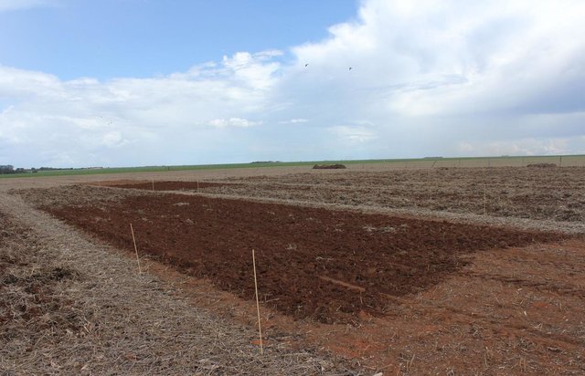
| Research | ການບໍ່ປະຕິບັດ | Research plots for demonstration. |
3.3 ແຜນວາດ (ຖ້າມີ)
ການອະທິບາຍ:
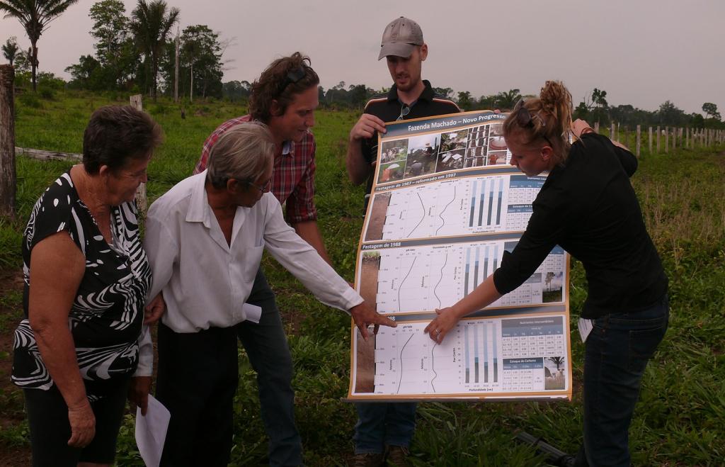
The scenario building process. Qualitative scenarios (“storylines”) were developed by an expert panel and successively refined with feedback from regional stakeholders and project partners. In the second step the storylines were interpreted, quantified, and used for scenario building and analysis based on computer models.
3.4 ການຕັດສິນໃຈກ່ຽວກັບການຄັດເລືອກເຕັກໂນໂລຢີຂອງການຄຸ້ມຄອງທີ່ດິນແບບຍືນຍົງ / ເຕັກໂນໂລຢີ
ລະບຸ ຄົນທີ່ຕັດສິນໃຈ ກ່ຽວກັບການຄັດເລືອກຂອງ ເຕັກໂນໂລຢີ / ເຕັກໂນໂລຢີ ຈະໄດ້ຮັບການປະຕິບັດ:
- ຜູ້ຊ່ຽວຊານ ຫຼັກດ້ານການຄຸ້ມຄອງ ທີ່ດິນແບບຍືນຍົງ, ມີການຕິດຕາມປຶກສາຫາລືກັບຜູ້ນໍາໃຊ້ທີ່ດິນ
ອະທິບາຍ:
Decisions on the method of implementing the SLM Technology were made by by land users* alone (self-initiative / bottom-up)
4. ການສະໜັບສະໜູນທາງດ້ານວິຊາການ, ການສ້າງຄວາມສາມາດ, ແລະ ການຈັດການຄວາມຮູ້.
4.1 ການສ້າງຄວາມສາມາດ / ການຝຶກອົບຮົມ
ຜູ້ນໍາໃຊ້ທີ່ດິນ ຫຼື ພາກສ່ວນກ່ຽວຂ້ອງອື່ນໆ ໄດ້ຮັບການຝຶກອົບຮົມບໍ່?
ແມ່ນ
ໃຫ້ລະບຸ ຜູ້ໃດທີ່ໄດ້ຮັບການຝຶກອົບຮົມ:
- ຜູ້ນໍາໃຊ້ດິນ
ຮູບແບບຂອງການຝຶກອົບຮົມ:
- ຕົວຕໍ່ຕົວ
- ເນື້ອທີ່ສວນທົດລອງ
- ກອງປະຊຸມ
ໃນຫົວຂໍ້:
Training focused on raising awareness of the consequences of “business-as-usual” behavior compared with other scenarios.
4.2 ການບໍລິການໃຫ້ຄໍາປຶກສາ
ເຮັດຜູ້ໃຊ້ທີ່ດິນມີການເຂົ້າເຖິງການບໍລິການໃຫ້ຄໍາປຶກສາ?
ແມ່ນ
ລະບຸວ່າການສະໜອງ ການບໍລິການ ໃຫ້ຄໍາປຶກສາ:
- ໃນພື້ນທີ່ຂອງຜູ້ນໍາໃຊ້ດິນ
ອະທິບາຍ / ຄວາມຄິດເຫັນ:
Name of method used for advisory service: dissemination of research results in the form of policy briefs and more detailed “output sticks”
Advisory service is quite adequate to ensure the continuation of land conservation activities
4.3 ສະຖາບັນການສ້າງຄວາມເຂັ້ມແຂງ (ການພັດທະນາອົງການຈັດຕັ້ງ)
ສະຖາບັນ ໄດ້ຮັບການສ້າງຕັ້ງຂື້ນ ຫຼື ໄດ້ຮັບການສ້າງຄວາມເຂັ້ມແຂງ ໂດຍການຈັດຕັ້ງປະຕິບັດ ວິທີທາງບໍ່?
- ບໍ່ມີ
4.4 ຕິດຕາມກວດກາ ແລະ ປະເມີນຜົນ
ການຈັດຕັ້ງປະຕິບັດ ວິທີທາງ ໄດ້ມີການປະເມີນຜົນ ແລະ ຕິດຕາມບໍ?
ແມ່ນ
ຄວາມຄິດເຫັນ:
bio-physical aspects were ad hoc monitored by project staff through observations
bio-physical aspects were ad hoc monitored by project staff through measurements
socio-cultural aspects were ad hoc monitored by project staff through observations
socio-cultural aspects were ad hoc monitored by project staff through measurements
There were few changes in the Approach as a result of monitoring and evaluation: Dissemination; form of dissemination was adjusted according to the requirements of target groups.
There were no changes in the Technology as a result of monitoring and evaluation
4.5 ການຄົ້ນຄວ້າ
ນີ້້ແມ່ນສ່ວນໜຶ່ງ ການຄົ້ນຄວ້າ ຂອງວິທີທາງບໍ່?
ແມ່ນ
ລະບຸ ຫົວຂໍ້:
- ລະບົບນິເວດ
- ເຕັກໂນໂລຢີ
ໃຫ້ຂໍ້ມູນ ເພີ່ມເຕີມ ແລະ ກໍານົດ ຜູ້ໃດເຮັດການຄົ້ນຄວ້າ:
Research was carried out both on station and on-farm
5. ການສະໜັບສະໜູນທາງດ້ານການເງິນ ແລະ ອຸປະກອນຈາກພາຍນອກ
5.1 ງົບປະມານປະຈໍາປີ ສໍາລັບວິທີທາງ ຂອງການຄຸ້ມຄອງ ທີ່ດິນແບບຍືນຍົງ
ຖ້າຫາກບໍ່ຮູ້ຈັດງົບປະມານທີ່ແນ່ນອນ ແມ່ນໃຫ້ປະມານເອົາ:
- 100,000-1,000,000
ຄໍາເຫັນ (ຕົວຢ່າງ: ແຫຼ່ງຂໍ້ມູນຫຼັກ ຂອງການສະໜອງທຶນ / ຜູ້ໃຫ້ທຶນທີ່ສໍາຄັນ):
Approach costs were met by the following donors: international (German Ministry of Education and Research BMBF): 100.0%
5.2 ການສະໜັບສະໜູນ ທາງດ້ານການເງິນ / ອຸປະກອນ ສະໜອງໃຫ້ແກ່ຜູ້ນໍາທີ່ດິນ
ຜູ້ນໍາໃຊ້ດິນ ໄດ້ຮັບການສະໜັບສະໜູນ ທາງດ້ານ ການເງິນ / ອຸປະກອນ ໃນການຈັດຕັ້ງປະຕິບັດ ເຕັກໂນໂລຢີບໍ?
ບໍ່ແມ່ນ
5.4 ສິນເຊື່ອ
ໄດ້ປ່ອຍສິນເຊື່ອ ສະໜອງໃຫ້ພາຍໃຕ້ ວິທີການສໍາລັບກິດຈະກໍາ ການຄຸ້ມຄອງ ທີ່ດິນແບບຍືນນຍົງບໍ່?
ບໍ່ແມ່ນ
6. ວິເຄາະຜົນກະທົບ ແລະ ສັງລວມບັນຫາ
6.1 ຜົນກະທົບຂອງແນວທາງ
ການຈັດຕັ້ງປະຕິບັດ ວິທີທາງ ສາມາດຊ່ວຍຜູ້ນໍາໃຊ້ທີ່ດິນ ໃນການຈັດຕັ້ງປະຕິບັດ ແລະ ບໍາລຸງຮັກສາ ເຕັກໂນໂລຢີ ການຄຸ້ມຄອງ ທີ່ດິນແບບຍືນຍົງໄດ້ບໍ?
- ບໍ່
- ມີ, ໜ້ອຍໜຶ່ງ
- ມີ, ພໍສົມຄວນ
- ມີ, ຫຼາຍ
Identification of method of applying organic matter to soil; identification of kind of agriculture most suitable for specific region/area; type of crop sown; crop sowing dates; economic return/economic optimization.
ການຈັດຕັ້ງປະຕິບັດ ວິທີທາງ ສາມາດສ້າງຄວາມເຂັ້ມແຂງ ທາງສັງຄົມ ແລະ ເສດຖະກິດບໍ່?
- ບໍ່
- ມີ, ໜ້ອຍໜຶ່ງ
- ມີ, ພໍສົມຄວນ
- ມີ, ຫຼາຍ
ການຈັດຕັ້ງປະຕິບັດ ວິທີທາງ ສາມາດປັບປຸງ ປະເດັນການຖືຄອງທີ່ດິນ / ສິດທິໃນການນໍາໃຊ້ທີ່ດິນ ທີ່ເຊື່ອງຊ້ອນໃນການຈັດຕັ້ງປະຕິບັດ ເຕັກໂນໂລຢີ ການຄຸ້ມຄອງ ທີ່ດິນແບບຍືນຍົງໄດ້ບໍ?
- ບໍ່
- ມີ, ໜ້ອຍໜຶ່ງ
- ມີ, ພໍສົມຄວນ
- ມີ, ຫຼາຍ
Research had no effect on land tenure; research was not aimed at solving the problem, rather research helped to identify the problem. The problem is likely to be overcome in the near future. reforms of land tenure rights underway
Did other land users / projects adopt the Approach?
- ບໍ່
- ມີ, ໜ້ອຍໜຶ່ງ
- ມີ, ພໍສົມຄວນ
- ມີ, ຫຼາຍ
Did the Approach lead to improved livelihoods / human well-being?
- ບໍ່
- ມີ, ໜ້ອຍໜຶ່ງ
- ມີ, ພໍສົມຄວນ
- ມີ, ຫຼາຍ
Did the Approach help to alleviate poverty?
- ບໍ່
- ມີ, ໜ້ອຍໜຶ່ງ
- ມີ, ພໍສົມຄວນ
- ມີ, ຫຼາຍ
6.2 ແຮງຈູງໃຈຫຼັກຂອງຜູ້ນໍາໃຊ້ທີ່ດິນໃນການປະຕິບັດການຄຸ້ມຄອງທີ່ດິນແບບຍືນຍົງ
- ການຜະລິດເພີ່ມຂຶ້ນ
- ກໍາໄລເພີ່ມຂຶ້ນ (ຄວາມສາມາດ), ການປັບປຸງຄ່າໃຊ້ຈ່າຍ, ຜົນປະໂຫຍດ, ອັດຕາສ່ວນ
- ການຊໍາລະເງິນ / ເງິນອຸດໜູນ
- ກົດລະບຽບແລະລະບຽບການ (ລະອຽດ) / ການບັງຄັບໃຊ້
- well-being and livelihoods improvement
6.3 ຄວາມຍືນຍົງຂອງກິດຈະກໍາວິທີທາງ
ຜູ້ນໍາໃຊ້ ທີ່ດິນ ສາມາດສືບຕໍ່ ການຈັດຕັ້ງປະຕິບັດ ຜ່ານວິທີທາງໄດ້ບໍ່ (ໂດຍປາດສະຈາກ ການຊ່ວຍເຫຼືອ ຈາກພາກສ່ວນພາຍນອກ)?
- ແມ່ນ
ຖ້າ ໄດ້, ອະທິບາຍເຫດຜົນ:
No-till agriculture, crop rotations, recommended sowing dates, expanding agricultural land according to crop yield information, and information regarding negative effects of cropland/rangeland expansion (e.g. soil and site specific GHG emissions) which were identified through the different scenarios.
6.4 ຈຸດແຂງ / ຂໍ້ດີ ຂອງວິທີທາງ
| ຈຸດແຂງ / ຈຸດດີ / ໂອກາດ ຈາກທັດສະນະຂອງຜູ້ປ້ອນຂໍ້ມູນ ຫຼື ບຸກຄົນສຳຄັນ |
|---|
| improved choice of crop/crop rotation; more environmental friendly choice of kind of agriculture employed (agroforestry systems); improved awareness of existence and functionality of regulations in favor of sustainability better dissemination; heightened awareness of land users to sustainability topics and environmental degradation |
6.5 ຈຸດອ່ອນ / ຂໍ້ເສຍຂອງແນວທາງ ແລະ ວິທີການແກ້ໄຂໃຫ້ເຂົາເຈົ້າ
| ຈຸດອ່ອນ ຫຼື ຂໍ້ເສຍ ຫຼື ຄວາມສ່ຽງ ໃນມຸມມອງຂອງ ຜູ້ສັງລວມຂໍ້ມູນ ຫຼື ບັນດາຜູ້ຕອບແບບສອບຖາມ | ມີວິທີການແກ້ໄຂຄືແນວໃດ? |
|---|---|
| Acceptance of results by famers, planning authorities, decision makers in general (political level). |
7. ເອກກະສານອ້າງອີງ ແລະ ຂໍ້ມູນການເຊື່ອມໂຍງ
7.1 ວິທີການ / ແຫຼ່ງຂໍ້ມູນ
- ການໄປຢ້ຽມຢາມພາກສະໜາມ, ການສໍາຫຼວດພາກສະໜາມ
- ການສໍາພາດ ຜູ້ນໍາໃຊ້ທີ່ດິນ
7.2 ເອກະສານທົ່ວໄປທີ່ສາມາດໃຊ້ໄດ້
ຫົວຂໍ້, ຜູ້ຂຽນ, ປີ, ISBN:
J. Goepel et al. (2016) Future scenarios of land-use and land-cover change in Southern Amazonia and resultant greenhouse gas emissions from agricultural soils, to be published in Regional Environmental Change Special Issue “Southern Amazonia”,(in review)
ຫົວຂໍ້, ຜູ້ຂຽນ, ປີ, ISBN:
Schönenberg et al. (2016)Inter- and transdisciplinary scenario construction to explore future land use options in Southern Amazonia, to be published in Ecology & Society (in review)
ຫົວຂໍ້, ຜູ້ຂຽນ, ປີ, ISBN:
R. Schaldach et al. (to be published) A multi-scale modelling framework for the analysis of societal and environmental processes in Southern Amazonian land systems: Lessons learned from the Carbiocial project.
ຂໍ້ມູນການເຊື່ອມຕໍ່ ແລະ ເນື້ອໃນ
ຂະຫຍາຍທັງໝົດ ຍຸບທັງໝົດການເຊື່ອມຕໍ່
Carbon-enrichment of tropical agricultural soil with organic matter [ບາຊິວ]
Carbon-enrichment of tropical agricultural soils with locally available organic matter in the Cerrado agricultural landscape, Brazil.
- ຜູ້ສັງລວມຂໍ້ມູນ: Luisa F. Vega
ເນື້ອໃນ
ບໍ່ມີເນື້ອໃນ